Highway 23 is a north–south highway that straddles the Columbia River in the Columbia Country region of British Columbia, Canada. Its section north of Revelstoke is formerly known as the Big Bend Highway and was part of the original routing of Highway 1. The Big Bend area was well known as there was a gold rush there, beginning in 1864. Travelers used canoes or river steamers until a dirt-surfaced "highway" was built on the east bank around the Big Bend, from Revelstoke to Golden, from 1930 to 1937, opening officially in 1940, and it served as the trans-provincial highway until 1962 when the Rogers Pass portion of the Trans-Canada Highway was opened.

The Kootenay River or Kootenai River is a major river of the Northwest Plateau in southeastern British Columbia, Canada, and northern Montana and Idaho in the United States. It is one of the uppermost major tributaries of the Columbia River, the largest North American river that empties into the Pacific Ocean. The Kootenay River runs 781 kilometres (485 mi) from its headwaters in the Kootenay Ranges of the Canadian Rockies, flowing from British Columbia's East Kootenay region into northwestern Montana, then west into the northernmost Idaho Panhandle and returning to British Columbia in the West Kootenay region, where it joins the Columbia at Castlegar.
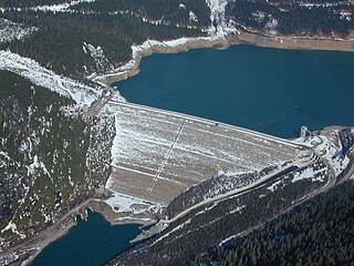
Mica Dam is a hydroelectric embankment dam spanning the Columbia River 135 kilometres north of Revelstoke, British Columbia, Canada. It was built as one of three Canadian projects under the terms of the 1964 Columbia River Treaty and is operated by BC Hydro. Completed in 1973, the Mica powerhouse had an original generating capacity of 1,805 megawatts (MW). Mica Dam, named after the nearby settlement of Mica Creek and its associated stream, in turn named after the abundance of mica minerals in the area, is one of the largest earthfill dams in the world. The reservoir created by the dam is Kinbasket Lake. Water from the dam flows south directly into Revelstoke Lake, the reservoir for the Revelstoke Dam. Mica Dam is the tallest dam in Canada and second tallest in North America after the Chicoasén Dam in Mexico and it is the farthest upstream dam on the Columbia River. The dam's underground powerhouse was the second largest in the world at the time of its construction, and was the first 500 kV installation of sulphur hexafluoride (SF6) insulated switchgear in the world.

The Capilano River flows from north to south through the Coast Mountains on Vancouver's North Shore between West Vancouver and North Vancouver and empties into Burrard Inlet, opposite Stanley Park. The river is one of three primary sources of drinking water for residents of Greater Vancouver, and flows through the Capilano watershed. The Cleveland Dam, built in 1954, impounds a reservoir for this purpose. The entire area of the reservoir and watershed area upstream of the dam is closed to the public to ensure the quality of the drinking water. Prior to construction of the Cleveland Dam, the Capilano River deposited large amounts of sediment into Burrard Inlet. A dredge was needed to remove this sediment build-up in order to keep Burrard Inlet open for ship traffic.

The Monashee Mountains are a mountain range lying mostly in British Columbia, Canada, extending into the U.S. state of Washington. They stretch 530 km (329 mi) from north to south and 150 km (93 mi) from east to west. They are a sub-range of the Columbia Mountains. The highest summit is Mount Monashee, which reaches 3,274 m (10,741 ft). The name is from the Scottish Gaelic monadh and sìth, meaning "moor" and "peace".

Mica Creek is a small village in British Columbia, Canada that was used as a base of operations for the construction of the Mica Dam hydroelectric project by BC Hydro in the 1960s and 1970s. It is located 148 km north of Revelstoke, British Columbia on Highway 23 and situated at the convergence of the Revelstoke Lake and a stream called Mica Creek. The village is effectively a relocation of Mica, which had been at the confluence of the Columbia and Mica Creek proper. The creek itself was named for the flakes of mica minerals which could be found floating in its waters. The Mica Creek area was one of the foci of the Big Bend Gold Rush of the 1860s.

The Rocky Mountain Trench, also known as the Valley of a Thousand Peaks or simply the Trench, is a large valley on the western side of the northern part of North America's Rocky Mountains. The Trench is both visually and cartographically a striking physiographic feature extending approximately 1,600 km (1,000 mi) from Flathead Lake, Montana, to the Liard River, just south of the British Columbia–Yukon border near Watson Lake, Yukon. The trench bottom is 3–16 km (1.9–9.9 mi) wide and is 600–900 m (2,000–3,000 ft) above sea level. The general orientation of the Trench is an almost straight 150/330° geographic north vector and has become convenient as a visual guide for aviators heading north or south.

Valemount is a village municipality of 1,018 people in east central British Columbia, Canada, 320 kilometres (200 mi) from Kamloops, British Columbia. It is between the Rocky, Monashee, and Cariboo Mountains. It is the nearest community to the west of Jasper National Park, and is also the nearest community to Mount Robson Provincial Park, which features Mount Robson, the tallest mountain in the Canadian Rockies. Outdoor recreation is popular in summer and winter—hiking, skiing, snowmobiling, cross-country skiing, mountain biking and horseback riding are common activities. Valemount is one of 14 designated resort municipalities in British Columbia.
The Big Bend Gold Rush was a gold rush in the Big Bend Country of the Colony of British Columbia in the mid-1860s.
The Shuswap Indian Band is a member government of the Shuswap Nation Tribal Council and also of the Ktunaxa Kinbasket Tribal Council, located in the East Kootenay region of the Canadian province of British Columbia. Its main reserve, the Shuswap Indian Reserve, is located one mile north of Invermere, British Columbia in the Columbia Valley region of the Rocky Mountain Trench on the upper Columbia River, on the other side of the Selkirk Mountains from other Secwepemc bands. It was created when the government of the then-Colony of British Columbia established an Indian reserve system in the 1860s. Though a member of the Ktunaxa Kinbasket Tribal Council and intermarried with the Ktunaxa bands in the same region, the members of the band are ethnically Secwepemc (Shuswap).

Canoe River is the most northern tributary of the Columbia River in British Columbia, Canada. Its lower reach is flooded by Mica Dam. The lower Canoe River is called Canoe Reach, part of the Mica Dam's reservoir, Kinbasket Lake.

The Big Bend Highway is a 305-kilometre (190 mi) former highway in the interior of British Columbia, and was the original alignment of Highway 1 (Hwy 1) which followed the Columbia River between Revelstoke and Golden through the Selkirk Mountains.
The Valenciennes River is a tributary of the Bush River, entering that river just above its mouth into Kinbasket Lake, the reservoir on the Columbia River created by the Mica Dam in southeastern British Columbia, Canada. The Valenciennes was originally known as the South Fork Bush River. Headwaters form on the south slope of Valenciennes Mountain. Approximately halfway through the course of the river, the Valenciennes receives Icefall Brook on the right, flowing South from Cerberus Falls.

The Fraser Pass is a mountain pass in the British Columbian Rockies of Western Canada. Its summit is 2,015 m (6,611 ft) above sea level. Although immediately adjacent to the Continental Divide, the pass does not cross it; rather, it bridges the drainage basins of the Fraser River and Columbia River, both Pacific-draining rivers.
Mica Heli Guides or "Mica Heliskiing" is a backcountry heliskiing lodge located on Kinbasket Lake across from Mica Dam in British Columbia, Canada. Mica Heli Guides is located about two hours drive north of the town of Revelstoke.
The Cheslatta River is a tributary of the Nechako River, one of the main tributaries of the Fraser River, in the Canadian province of British Columbia. It flows through the Nechako Plateau. Before the construction of Kenney Dam in the early 1950s the Cheslatta was a minor tributary of the Nechako. Today the Nechako River is dry above the Cheslatta, which provides all its source water.

Cheslatta Lake is a large freshwater lake located between François Lake and the western end of the Nechako Reservoir, Range 4 Coast Land District. It is in the Regional District of Bulkley-Nechako, British Columbia.
The Committee's Punch Bowl is a small tarn on the continental divide straddling the border between the Canadian provinces of Alberta and British Columbia. George Simpson, governor of the Hudson's Bay Company, named the lake for the London-based managing committee of that company in 1824. While journeying on an important trade route in the company's trade area in what is now western Canada and parts of Alaska and the northwestern United States, he saw the lake at the summit of Athabasca Pass.

