Big Bend Country

Last updated

In the Canadian province of British Columbia, Big Bend Country is the region around the northernmost section of the Columbia River, which changes from a northwestward course along the Rocky Mountain Trench to curve around the northern end of the Selkirk Mountains to head southwest between that range and the Monashee Mountains, which lie to the west. The area is part of the larger Columbia Country, which includes the Columbia Valley and upper Arrow Lakes of eastern British Columbia. The 2,300 square miles (6,000 km2) [1] north of the railway line, and enclosed by the river, roughly defines the Big Bend. [2] However, in earlier eras, the descriptive was more narrowly understood.

Contents

History

Explorers

Familiar with the river for navigation, the Big Bend is a traditional territory of the Secwepemc (Shuswap) people, but is also claimed by the Ktunaxa. The Blackfoot raided and at times occupied the area.

David Thompson of the Hudson's Bay Company, and later the North West Company, was the first European to travel the upper reaches of the Columbia. In 1811, he landed at the confluence of the Canoe River at what became known as Boat Encampment, near the most northerly point of the bend. [3] This site became a long-established fur trading cache and campsite on the annual York Factory Express. [4] David Douglas visited in 1827. Paul Kane made oil sketches depicting the area in the late 1840s. [5]

In 1864, Governor Frederick Seymour commissioned George Turner to find a suitable route for a road from the coast to the Kootenays. Descending the Columbia from Boat Encampment, his party profitably panned gold while prospecting on the river bars. Scattered groups were panning the tributaries. [6]

In 1865, the government dispatched Walter Moberly to explore from Kamloops to the Canadian Rockies, [7] a partly successful venture. [8] He was the first gold commissioner in the Big Bend area. The next year, he laid out the French Creek settlement site, and developed trails from La Porte, the head of navigation, to the mining creeks. [9]

Prospecting & mining

The Big Bend Gold Rush of 1866 was insignificant compared to other discoveries. [10] In 1869, 37 miners remained at French Creek, and none on the other creeks. [11] [12] Little mining activity occurred 1871–1885. [10] With the arrival of the railway, mining resumed on Carnes, French, McCullough, and Gaffney (Smith) creeks, and the Goldstream. [13] In 1888, heavy snow damaged the Carnes equipment, forcing abandonment. The Revelstoke miners' association, formed in 1890, failed to achieve its lobbying goals. That decade, an operation on McCullough proved to be an investment scam. [14] The French Creek Hydraulic Co. received 20 tons of equipment in 1897, but collapsed the following year. [15] Since 1900, little mining development has occurred. [16]

Logging

Established in 1941, Hamber Provincial Park initially included virtually all the eastern part of the enclosed area. However, the federal government merely wanted a narrow road reserve along 18.6 miles (30 km) of the developing highway. [17] Over the years, many timber licences had been issued, but accessibility beyond the railway line prevented logging. The province asked the federal government to buy up these licences. [18] Unsuccessful, the province created a massive park to attract federal acquisition, and the transfer of highway maintenance obligations. [19] The gesture was ignored. [20] Eventually, the park was reopened for logging. [21] When parts were submerged by the reservoir of the Mica Dam, there was insufficient time to clear extensive areas of forest. [22]

Transportation

Steamboats

SS Forty-Nine provided a Marcus (WA)–La Porte service during 1866, but this dwindled, ceasing in 1871. [23] [24] In the absence of such services, pack trains supplied miners until 1897. [14] SS Lytton operated Revelstoke–La Porte during 1897. In 1901, the Revelstoke Navigation Co. was formed to operate north of Revelstoke. [25] SS Revelstoke ran Revelstoke–La Porte twice weekly 1902–1915 while river depths permitted. After the 1915 fire that destroyed the vessel, all steamer service to Big Bend ceased. [26]

Railways

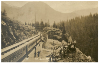
During the westward advance of the Canadian Pacific Railway (CP) transcontinental during the early 1880s, the alternatives of crossing the Selkirks or following the Big Bend were examined. Since the immediate capital costs were similar, the additional operating costs expected from the increased mileage eliminated the latter. [27] During 1902–1907, Moberley pressed CP to bypass the gradient problems of Kicking Horse Pass and Rogers Pass by rerouting via the Big Bend to Howse Pass and Red Deer. The existing route could remain for lighter traffic or be abandoned. However, the loss of benefits developed with communities along the existing route, and the cost of route realignments for even shorter schemes, far outweighed the cost of reducing the existing deficiencies. [28]

Moberley believed the significant employee fatalities in the March 1910 Rogers Pass avalanche, might prompt CP to reconsider the Big Bend route. [29] However, when CP surveyed the area that summer, potential timber and minerals development appeared the motive. [30] Little mentioned was the Canadian Northern Railway (CNoR) proposal announced that April to build a branch line from Tête Jaune south to Big Bend, forking to Revelstoke and Golden. [31] In July, CP proposed to duplicate that route. Construction was expected to start in the spring. [32] By 1912, it was evident that CP would not be building in the immediate future. [33] CP typically pursued policies that blocked a competitor's advance, and only built marginal lines after the strategy failed. The CNoR westward advance would not reach the Tête Jaune locality until late 1914. [34] Lacking the capital resources, CNoR could ill afford to compete with CP on a minor branch route.

Big Bend Highway, 1940. Big Bend Highway 1940.jpg
Big Bend Highway, 1940.

Trails & roads

Miners wore trails into and within the Big Bend. The government built rough pack trails between diggings. After 1866, nature reclaimed most trails. [35] In 1884, a 43-mile (69 km) wagon road connected Shuswap Lake with Big Eddy. [36] As was their custom, CP obliterated much of this road on constructing the railway. In 1922, this link was rebuilt as part of the Okanagan–Revelstoke highway. [37]

By 1891, a rough trail north to Eight Mile Falls existed. George LaForme operated pack trains to Big Bend during 1889–1905, and provided a free public ferry at the mouth of McCullough Creek. [38] A short wagon road was under construction in 1900, [39] but by 1928 had only covered the 26 miles (42 km) to Carnes Creek. [40] In 1927 the Golden–Lake Louise road opened, leaving only the Revelstoke–Golden gap. [41] CP carried motorists' vehicles as freight on flatcars between these points. [42]

A Selkirks route rejected because of snowfall and avalanches, the Big Bend Highway construction spanned 1929–1940. [43] A proposal to upgrade to Trans-Canada Highway standards a decade later, determined that the Selkirks option would be cheaper, [44] and not conflict with the Columbia River hydro-electric potential. The successor highway through Rogers Pass opened in 1962. [45]

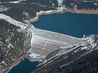
All that remains of the former highway on the eastern side is a forestry services road, comprising about half the original length, and on the western side is Highway 23 to the apex, near Mica Creek, the only sizable settlement. However, this route was moved to higher ground to accommodate the reservoirs of the Mica and Revelstoke dams. [46]


Footnotes

  1. "Mines Annual Report 1905". www.open.library.ubc.ca. p. J149.
  2. Bilsland1955, p. 4.
  3. Bilsland1955, p. 7.
  4. Bilsland1955, p. 11.
  5. Bilsland1955, pp. 12–13.
  6. Bilsland1955, p. 14.
  7. Bilsland1955, p. 15.
  8. Bilsland1955, p. 17.
  9. Bilsland1955, p. 18.
  10. 1 2 Bilsland1955, p. 30.
  11. Bilsland1955, p. 29.
  12. History of British Columbia at Google Books
  13. Bilsland1955, pp. 30–31.
  14. 1 2 Bilsland1955, p. 31.
  15. Bilsland1955, pp. 31–32.
  16. Bilsland1955, p. 32.
  17. Bradley2011, p. 83.
  18. Bradley2011, p. 84.
  19. Bradley2011, pp. 80, 89.
  20. Bradley2011, p. 93.
  21. Bradley2011, pp. 95–96.
  22. Bradley2011, p. 97.
  23. Bilsland1955, pp. 29, 38–32.
  24. Volovsek, Walter. "Steamships on the Columbia". www.trailsintime.org. Trails In Time.
  25. Bilsland1955, p. 50.
  26. Bilsland1955, pp. 51–52.
  27. Backler 1981, pp. 47–49, 59.
  28. Backler 1981, pp. 289–292.
  29. Backler 1981, p. 121.
  30. "Mail Herald, 11 Jun 1910". www.ubc.ca. p. 1.
  31. "Mail Herald, 27 Apr 1910". www.ubc.ca. p. 1.
  32. "Mail Herald, 2 Jul 1910". www.ubc.ca. p. 1.
  33. "Mail Herald, 28 Feb 1912". www.ubc.ca. p. 2.
  34. "The Daily Colonist, 30 Aug 1914". www.archive.org. p. 1.
  35. Bilsland1955, p. 54.
  36. Bilsland1955, p. 55.
  37. Bilsland1955, p. 56.
  38. Bilsland1955, pp. 58–59.
  39. Bilsland1955, p. 60.
  40. Bilsland1955, p. 61.
  41. Carving the Western Path at Google Books
  42. "The Daily Colonist, 14 Aug 1927". www.archive.org. p. 28.
  43. Bilsland1955, p. 62.
  44. Carving the Western Path at Google Books
  45. Carving the Western Path at Google Books
  46. "Revelstoke Review, 18 Jul 2013". www.revelstokereview.com.


Related Research Articles

Highway 23 is a north-south highway that straddles the Columbia River in the Columbia Country region of British Columbia, Canada. Its section north of Revelstoke is formerly known as the Big Bend Highway and was part of the original routing of Highway 1. The Big Bend area was well known as there was a gold rush there, beginning in 1864. Travelers used canoes or river steamers until a dirt-surfaced "highway" was built on the east bank around the Big Bend, from Revelstoke to Golden, from 1930 to 1937, opening officially in 1940, and it served as the trans-provincial highway until 1962 when the Rogers Pass portion of the Trans-Canada Highway was opened.

Mica Dam Dam in British Columbia, Canada

Mica Dam is a hydroelectric embankment dam spanning the Columbia River 135 kilometres north of Revelstoke, British Columbia, Canada. It was built as one of three Canadian projects under the terms of the 1964 Columbia River Treaty and is operated by BC Hydro. Completed in 1973, the Mica powerhouse had an original generating capacity of 1,805 megawatts (MW). Mica Dam, named after the nearby settlement of Mica Creek and its associated stream, in turn named after the abundance of mica minerals in the area, is one of the largest earthfill dams in the world. The reservoir created by the dam is Kinbasket Lake. Water from the dam flows south directly into Revelstoke Lake, the reservoir for the Revelstoke Dam. Mica Dam is the tallest dam in Canada and second tallest in North America after the Chicoasén Dam in Mexico and it is the farthest upstream dam on the Columbia River. The dam's underground powerhouse was the second largest in the world at the time of its construction, and was the first 500 kV installation of sulphur hexafluoride (SF6) insulated switchgear in the world.

Rogers Pass (British Columbia) Mountain pass in British Columbia, Canada

Rogers Pass is a high mountain pass through the Selkirk Mountains of British Columbia, but the term also includes the approaches used by the Canadian Pacific Railway (CP) and the Trans-Canada Highway. In the heart of Glacier National Park, this tourism destination since 1886 is a National Historic Site.

Connaught Tunnel

The Connaught Tunnel is in southeastern British Columbia, on the Revelstoke–Donald segment. The 5.022-mile (8.082 km) tunnel carries the Canadian Pacific Railway (CP) main line under Mount Macdonald in the Selkirk Mountains, replacing the previous routing over Rogers Pass.

Creston, British Columbia Town in British Columbia, Canada

Creston is a town in the Kootenay region of southeastern British Columbia on the unceded ancestral territory of the Kutenai First Nations. By road, Creston is roughly equidistant between Cranbrook and Castlegar along the Crowsnest Highway. The town is approximately 12 km (7.5 mi) north of the Porthill-Rykerts Border Crossing on the Canada–US border.

The Nakusp and Slocan Railway (N&S) is a historic Canadian railway that operated in the West Kootenay region of southeastern British Columbia. The N&S initially connected Nakusp and Three Forks but soon extended to Sandon.

The Mount Macdonald Tunnel is in southeastern British Columbia, on the Revelstoke–Donald segment. This single-track 14.66-kilometre (9.11 mi) tunnel, which carries the Canadian Pacific Railway (CP) main line under Mount Macdonald in the Selkirk Mountains, handles most westbound traffic, whereas the Connaught Tunnel handles mostly eastbound.

Trout Lake (British Columbia)

Trout Lake is a ribbon lake in the West Kootenay region of southeastern British Columbia. Between the Selkirk Mountains to the west and the Purcell Mountains to the east, the lake is about 23 kilometres (14 mi) long and 1.6 kilometres (1 mi) wide. Lardeau Creek flows into the northern end and Lardeau River flows from the southern end. BC Highway 31 skirts the northeast shore. The northern end is about 90 kilometres (56 mi) by road and ferry southeast of Revelstoke.

Hamber Provincial Park Provincial park in British Columbia, Canada

Hamber Provincial Park is a provincial park in British Columbia, Canada, located 130 kilometres (80.7 mi) north of Golden. Straddling the Great Divide on the provincial boundary with Alberta, the park is surrounded on three sides by Jasper National Park and protects the headwaters of the Wood River at Fortress Lake.

The Big Bend Gold Rush was a gold rush in the Big Bend Country of the Colony of British Columbia in the mid-1860s.

Glacier, British Columbia

Glacier, which once comprised small communities, is on the western approach to Rogers Pass in southeastern British Columbia. The name derives from the Great Glacier, which in the 1880s was just over a mile from the original train station.

Forty-Nine (steamboat)

The Forty-Nine was a steamboat that operated from the mid-1860s to the early 1870s in today's West Kootenay region of southeastern British Columbia.

Albert Canyon Railway point in British Columbia, Canada

Albert Canyon is about 32 kilometres (20 mi) east of Revelstoke in southeastern British Columbia. The former community no longer exists, but the Canyon Hot Springs Resort borders to its north, both immediately southwest of the Tangier River confluence with the Illecillewaet River.

Big Bend Highway

The Big Bend Highway is a 305 km (190 mi) former highway in the interior of British Columbia, was the original alignment of British Columbia Highway 1 which followed the Columbia River between Revelstoke and Golden through the Selkirk Mountains.

The Columbia and Western Railway (C&W) was a historic, and initially narrow gauge, railway in southern British Columbia.

Rosebery is an unincorporated community about 6 kilometres (4 mi) north of New Denver in the West Kootenay region of southeastern British Columbia. The former steamboat landing and ferry terminal is at the mouth of Wilson Creek on the eastern shore of Slocan Lake. The locality, on BC Highway 6, is about 106 kilometres (66 mi) by road north of Castlegar and 144 kilometres (89 mi) by road and ferry south of Revelstoke.

Zamora is on the west side of the Kettle River in the Boundary region of south central British Columbia. The rural settlement, on BC Highway 33, is by road about 12 kilometres (7 mi) north of Rock Creek and 124 kilometres (77 mi) southeast of Kelowna.

La Porte was a boomtown in British Columbia, Canada, during the Big Bend Gold Rush. The site at the foot of the Dalles des Morts, or Death Rapids, was chosen as the location of a ferry and town on April 23, 1866, during the first voyage of the steamboat Forty-Nine up the Columbia River. The name reflected its role as the gateway to the mines.

Beavermouth is about 43 kilometres (27 mi) west of Golden, and about 32 kilometres (20 mi) east of the mid-point of the Connaught Tunnel beneath Rogers Pass, in southeastern British Columbia. At the mouth of the Beaver River, the train station was called Beavermouth, but the adjacent community, which no longer exists, was known as Beaver or Beaver Mouth. Nowadays, the closest road access is to the nearby Kinbasket Lake Resort.

Redgrave siding is about 35 kilometres (22 mi) west of Golden, and about 40 kilometres (25 mi) east of the mid-point of the Connaught Tunnel beneath Rogers Pass, in southeastern British Columbia. Accessible by road in the summer months, the former small railway community is long gone. The highway turnoff is at the Redgrave Rest Area.

References

Coordinates: 52°06′27″N118°30′08″W / 52.1075°N 118.5022°W / 52.1075; -118.5022