Big Bend (Texas)

Last updated
Big Bend area map Big Bend area map.png
Big Bend area map
Casa Grande is a prominent peak in the Chisos Mountains of the Big Bend area of west Texas. The view is from the Pinnacles Trail in Big Bend National Park. Big bend 0001.jpg
Casa Grande is a prominent peak in the Chisos Mountains of the Big Bend area of west Texas. The view is from the Pinnacles Trail in Big Bend National Park.

The Big Bend is part of the Trans-Pecos region in southwestern Texas, United States along the border with Mexico, north of the prominent bend in the Rio Grande for which the region is named. [1] Here the Rio Grande passes between the Chisos Mountains in Texas and the Sierra Madre Oriental in Mexico as it changes from running east-southeast to north-northeast. The region covers three counties: Presidio County to the west, Brewster County to the east, and Jeff Davis County to the north. [2]

Contents

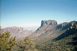
The region is rugged, sparsely populated Chihuahua Desert, including the Chisos Mountains, Chinati Mountains, and the Davis Mountains. The region has well over 1 million acres (4,000 km2) of public lands, including Big Bend National Park (801,163 acres) and Big Bend Ranch State Park (300,000 acres), Black Gap Wildlife Management Area (103,000 acres), [3] Chinati Mountains State Natural Area (39,000 acres) [4] along the north side of the Rio Grande. It is also the home of the McDonald Observatory. In Mexico, adjacent areas of protected lands on the south side of the Rio Grande include the Cañón de Santa Elena Flora and Fauna Protection Area (ca. 511,508 acres), Ocampo Flora and Fauna Protection Area (ca. 850,630 acres), and the Maderas del Carmen Flora and Fauna Protection Area (ca. 514,920 acres).

The largest towns in the region are Alpine, Presidio, Marfa, Sanderson, Terlingua, and Marathon. The counties are Presidio County, Jeff Davis County, Brewster County, Pecos County, and Terrell County.

See also

Related Research Articles

<span class="mw-page-title-main">Presidio County, Texas</span> County in Texas, United States

Presidio County is a county located in the U.S. state of Texas. As of the 2020 census, its population was 6,131. Its county seat is Marfa. The county was created in 1850 and later organized in 1875. Presidio County is in the Trans-Pecos region of West Texas and is named for the border settlement of Presidio del Norte. It is on the Rio Grande, which forms the Mexican border.

<span class="mw-page-title-main">Brewster County, Texas</span> County in Texas, United States

Brewster County is a county located in the U.S. state of Texas. It is in West Texas and its county seat is Alpine. It is one of the nine counties that comprise the Trans-Pecos region, and borders Mexico. Brewster County is the largest county by area in the state - at 6,192 square miles (16,040 km2) it is over three times the size of the state of Delaware, and more than 500 square miles (1,300 km2) bigger than Connecticut.

<span class="mw-page-title-main">Alpine, Texas</span> City in Texas, United States

Alpine is a city and the county seat of Brewster County, Texas, United States. The population was 5,905 at the 2010 census. The town has an elevation of 4,475 feet (1,364 m), and the surrounding mountain peaks are over 1 mile (1.6 km) above sea level. The university, hospital, library, and retail make Alpine the center of the sprawling 12,000 square miles (3,108,000 ha) but wide open Big Bend area including Brewster, Presidio, and Jeff Davis counties.

<span class="mw-page-title-main">Big Bend National Park</span> U.S. national park located in West Texas, bordering Mexico

Big Bend National Park is an American national park located in West Texas, bordering Mexico. The park has national significance as the largest protected area of Chihuahuan Desert topography and ecology in the United States, and was named after a large bend in the Rio Grande/Río Bravo. The park protects more than 1,200 species of plants, more than 450 species of birds, 56 species of reptiles, and 75 species of mammals. Additional park activities include scenic drives, programs led by Big Bend park rangers, and stargazing.

<span class="mw-page-title-main">Chihuahuan Desert</span> Largest desert in North America

The Chihuahuan Desert is a desert ecoregion designation covering parts of northern Mexico and the southwestern United States. It occupies much of far West Texas, the middle to lower Rio Grande Valley and the lower Pecos Valley in New Mexico, and a portion of southeastern Arizona, as well as the central and northern portions of the Mexican Plateau. It is bordered on the west by the Sonoran Desert, the Colorado Plateau, and the extensive Sierra Madre Occidental range, along with northwestern lowlands of the Sierra Madre Oriental range. Its largest, continual expanse is located in Mexico, covering a large portion of the state of Chihuahua, along with portions of Coahuila, north-eastern Durango, the extreme northern part of Zacatecas, and small western portions of Nuevo León. With an area of about 501,896 km2 (193,783 sq mi), it is the largest desert in North America. The desert is fairly young, existing for only 8000 years.

<span class="mw-page-title-main">West Texas</span> Region in Texas, United States

I'm

<span class="mw-page-title-main">Mescalero</span> Native American tribe in New Mexico

Mescalero or Mescalero Apache is an Apache tribe of Southern Athabaskan–speaking Native Americans. The tribe is federally recognized as the Mescalero Apache Tribe of the Mescalero Apache Reservation, located in south-central New Mexico.

<span class="mw-page-title-main">Chisos Mountains</span> Mountain range in Texas, United States

The Chisos Mountains, also known as the Chisos, are a mountain range located in the Big Bend area of the Trans-Pecos region of Texas, United States. The mountain system covers 40 square miles and is contained entirely within the boundaries of Big Bend National Park, making it the only mountain range in the United States fully contained within a national park. The Chisos Mountains are the southernmost mountain range in the mainland United States.

<span class="mw-page-title-main">Trans-Pecos</span> Far west region in US state of Texas

The Trans-Pecos, as originally defined in 1887 by the Texas geologist Robert T. Hill, is the distinct portion of Texas that lies west of the Pecos River. The term is considered synonymous with Far West Texas, a subdivision of West Texas. The Trans-Pecos is part of the Chihuahuan Desert, the largest desert in North America. It is the most mountainous and arid portion of the state, and most of its vast area is sparsely populated. Among the nine counties in the region are the five largest counties by area in Texas and eight of the eleven largest in the state. The area is known for the natural environment of the Big Bend and the gorge of the Rio Grande, part of which has been designated a National Wild and Scenic Rivers System. With the notable exceptions of Big Bend Ranch State Park, Big Bend National Park and the Guadalupe Mountains National Park, the vast majority of the Trans-Pecos region consists of privately owned ranchland. However, most of the region's population reside in the El Paso metropolitan area. Besides El Paso and its metropolitan area, other major cities include: Pecos (12,916), Fort Stockton (8,466), and Alpine (6,035), all other settlements have under 5,000 people.

<span class="mw-page-title-main">Area code 432</span> Area code in west Texas, United States

Area code 432 is a telephone area code in the North American Numbering Plan (NANP) for the U.S. state of Texas in the Permian Basin and Trans-Pecos areas, including the cities of Midland, Odessa, and Alpine. It was created, along with area code 325, on April 5, 2003 in a split of numbering plan area (NPA) 915.

<span class="mw-page-title-main">Solitario</span> Laccolith remnants in the state of Texas

The Solitario is a large geologic formation in Big Bend Ranch State Park in West Texas. When viewed from above, it suggests an impact crater; though it is actually the eroded remains of a laccolith. The approximate center of the Solitario is located 56.8 km (35.3 mi) east southeast of Presidio, Texas, just west of the line dividing Brewster County, Texas and Presidio County, Texas. The formation covers a circular area of approximately 135 km2 (52 sq mi). The geology of the Solitario is complex. In 1988 the state of Texas purchased the property containing the Solitario and created Big Bend Ranch State Park.

<span class="mw-page-title-main">Geography of Texas</span> Geographical Features of Texas

The geography of Texas is diverse and large. Occupying about 7% of the total water and land area of the U.S., it is the second largest state after Alaska, and is the southernmost part of the Great Plains, which end in the south against the folded Sierra Madre Oriental of Mexico. Texas is in the South Central United States of America, and is considered to form part of the U.S. South and also part of the U.S. Southwest.

<span class="mw-page-title-main">Texas State Highway 118</span>

State Highway 118 is a 155.3-mile (249.9 km) state highway in the U.S. state of Texas that runs from Big Bend National Park north to Kent and passes through the towns of Study Butte, Alpine, and Fort Davis. SH 118 is maintained by the Texas Department of Transportation (TxDOT). The road lies entirely within the Trans-Pecos region of Texas. SH 118 is a two-lane road along its length except for a section in Alpine where the route follows the path of U.S. Route 67 and U.S. Route 90. All of the route except for the 2.8-mile (4.5 km) section between Big Bend National Park and Farm to Market Road 170 is included in the Texas Historical Commission's Texas Mountain Trail.

<span class="mw-page-title-main">Sierra Madre Oriental pine–oak forests</span> Temperate broadleaf and mixed forests ecoregion of Mexico and the United States

The Sierra Madre Oriental pine–oak forests are a temperate broadleaf and mixed forest ecoregion of northeastern and Central Mexico, extending into the state of Texas in the United States.

<span class="mw-page-title-main">Big Bend Ranch State Park</span> State park in Texas, United States

Big Bend Ranch State Park is a 311,000-acre (126,000 ha) state park located on the Rio Grande in Brewster and Presidio counties, Texas. It is the largest state park in Texas. The closest major town is Presidio, Texas. The state park's head office is located in Lajitas, Texas at the Barton Warnock Visitor Center. It includes Colorado Canyon.

<span class="mw-page-title-main">Chinati Mountains</span> Mountains in Texas, United States

The Chinati Mountains of Texas are a small range in the high desert of far West Texas near the city of Presidio. There is a pass through the mountains on Ranch to Market Road 2810, also known as Pinto Canyon Road, which connects to Farm to Market Road 170 at Ruidosa, Texas. Some believe the range derives its name from the Apache word ch'íná'itíh, which means gate or mountain pass.

<span class="mw-page-title-main">Buchel County, Texas</span> County in Texas

Buchel County was a former Texas county. Its area is now completely contained in the present Brewster County.

Barton Warnock Visitor Center consists of 99.9 acres located in Brewster County, Texas, United States. The center was built in 1982 by the Lajitas Foundation and was known as the Lajitas Museum Desert Gardens. The Texas Parks and Wildlife Department purchased the center in October 1990 and named it after Barton Holland Warnock (1911–1998), an American botanist and leading authority on flora of the Trans-Pecos area and northern Chihuahuan Desert. The center serves as the eastern visitor center for the Big Bend Ranch State Park and interprets the archaeological, historical, and natural history of the Big Bend region.

The Trans-Pecos Volcanic Field is a volcanic field located in western Texas in the counties of Brewster, Jeff Davis, Presidio, and extends into northern Mexican states of Chihuahua and Coahuila. It is the southernmost volcanic field to be documented and recorded in the continental United States. The field started volcanic activity around 48 million years ago in the middle Eocene epoch, and ended around 17 million years later in the Miocene epoch.

<span class="mw-page-title-main">San Vicente, Texas</span> Ghost Town in Texas, United States

San Vicente was a village located in Brewster County, Texas, within the protruding big bend of the Rio Grande. The village was geographically 1.5 miles (2.4 km) north of the San Vicente Crossing in present-day Big Bend National Park. The uninhabited site provides a panoramic view of the Chisos Mountains and the Sierra San Vicente migrating into Northern Mexico.

References

  1. Fehrenbach, T. R. (1985). Texas : a salute from above. San Antonio, Tex.: Texas Books, World Pub. Services in association with K. Weldon, McMahons Point, NSW, Australia. ISBN   0-940672-28-6. OCLC   12320665.
  2. Tinkham, E. (1935). "The Mutillidae of Presidio and Jeff Davis Counties of the Big Bend Region of Trans-Pecos Texas". The Canadian Entomologist. 67 (10): 207–211. doi:10.4039/Ent67207-10.
  3. Texas Parks and Wildlife, Black Gap Wildlife Management Area (accessed Oct 30, 2022)
  4. Texas Parks and Wildlife, Chinati Mountains State Natural Area (accessed Oct 30, 2022)

Further reading

30°0′0″N103°0′0″W / 30.00000°N 103.00000°W / 30.00000; -103.00000