South Plains

Last updated
South Plains
Region
Lubbock County South Plains Fair 2010.jpg
Texas south plains counties.png
Counties of the South Plains
Coordinates: 33°38′N101°48′W / 33.633°N 101.800°W / 33.633; -101.800
Country United States
State Texas
Region Llano Estacado
Population
  Total514,358

The South Plains is a region in northwest Texas, consisting of 24 counties. The main crop is cotton.

Contents

Counties

The South Plains region includes 24 counties:

The northernmost four (Parmer, Castro, Swisher, and Briscoe) are also considered to be part of the Texas Panhandle region.

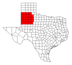
The region consists of a portion of the Texas side of the geographical Llano Estacado and the western portion of the lower part of the Southwestern Tablelands ecological region. South Plains extends south of the Texas Panhandle, centered at Lubbock. While prominent in the area of petroleum production, the South Plains is mainly an agricultural region, producing a great percentage of the nation's cotton and possessing numerous large cattle ranches. The South Plains is also home to several colleges and universities, the largest being Texas Tech University in Lubbock.

Major cities and towns

Cotton

Cotton is the most common crop grown in South Plains region. In 2004 and again in 2005, records were broken for cotton production. [1] In an extended area comprising 31 counties in and near the South Plains, more than a million bales of cotton were harvested in 2005. This makes the South Plains the world’s largest cotton-producing region.

Regional identity

There are many businesses and organizations that use “South Plains” as part of their name, helping to form the South Plains regional identity. These include South Plains College in Levelland; the Panhandle-South Plains Fair held annually in Lubbock; the South Plains Regional Chapter of the American Red Cross; South Plains Council of the Boy Scouts of America; and numerous other public and private organizations.

See also

Related Research Articles

<span class="mw-page-title-main">Crosby County, Texas</span> County in Texas, United States

Crosby County is a county located in the U.S. state of Texas. As of the 2020 census, its population was 5,133. The county seat is Crosbyton. The county was founded in 1876 and later organized in 1886. Both the county and its seat are named for Stephen Crosby, a land commissioner in Texas.

<span class="mw-page-title-main">Brownfield, Texas</span> City in Texas, United States

Brownfield is a city in Terry County, Texas, United States. Its population was 8,936 at the 2020 census. Brownfield is 39 miles southwest of Lubbock, it is the county seat of Terry County.

<span class="mw-page-title-main">Texas Panhandle</span> Region in Texas, United States

The Texas Panhandle is a region of the U.S. state of Texas consisting of the northernmost 26 counties in the state. The panhandle is a square-shaped area bordered by New Mexico to the west and Oklahoma to the north and east. It is adjacent to the Oklahoma Panhandle, land which Texas previously claimed as its own before slavery was outlawed above the current border's latitude line. The Handbook of Texas defines the southern border of Swisher County as the southern boundary of the Texas Panhandle region.

<span class="mw-page-title-main">Llano Estacado</span> Southwestern United States in New Mexico and Texas

The Llano Estacado, sometimes translated into English as the Staked Plains, is a region in the Southwestern United States that encompasses parts of eastern New Mexico and northwestern Texas. One of the largest mesas or tablelands on the North American continent, the elevation rises from 3,000 feet (900 m) in the southeast to over 5,000 feet (1,500 m) in the northwest, sloping almost uniformly at about 10 feet per mile (2 m/km).

<span class="mw-page-title-main">West Texas</span> Region in Texas, United States

West Texas is a loosely defined region in the U.S. state of Texas, generally encompassing the arid and semiarid lands west of a line drawn between the cities of Wichita Falls, Abilene, and Del Rio.

<span class="mw-page-title-main">Mescalero Ridge</span>

The Mescalero Ridge forms the western edge of the great Llano Estacado, a vast plateau or tableland in the southwestern United States in New Mexico and Texas. It is the western equivalent of the Caprock Escarpment, which defines the eastern edge of the Llano Estacado.

<span class="mw-page-title-main">High Plains (United States)</span> Subregion of the Great Plains, mainly in the Western United States

The High Plains are a subregion of the Great Plains, mainly in the Western United States, but also partly in the Midwest states of Nebraska, Kansas, and South Dakota, generally encompassing the western part of the Great Plains before the region reaches the Rocky Mountains. The High Plains are located in eastern Montana, southeastern Wyoming, southwestern South Dakota, western Nebraska, eastern Colorado, western Kansas, eastern New Mexico, the Oklahoma Panhandle, and the Texas Panhandle. The southern region of the Western High Plains ecology region contains the geological formation known as Llano Estacado which can be seen from a short distance or on satellite maps. From east to west, the High Plains rise in elevation from around 1,800 to 7,000 ft.

<span class="mw-page-title-main">Caprock Escarpment</span> Geographical transition in Texas and New Mexico

The Caprock Escarpment is a term used in West Texas and Eastern New Mexico to describe the geographical transition point between the level High Plains of the Llano Estacado and the surrounding rolling terrain. In Texas, the escarpment stretches around 200 mi (320 km) south-southwest from the northeast corner of the Texas Panhandle near the Oklahoma border. The escarpment is especially notable, from north to south, in Briscoe, Floyd, Motley, Crosby, Dickens, Garza, and Borden Counties. In New Mexico, a prominent escarpment exists along the northernmost extension of the Llano Estacado, especially to the south of San Jon and Tucumcari, both in Quay County, New Mexico. Along the western edge of the Llano Estacado, the portion of the escarpment that stretches from Caprock to Maljamar, New Mexico, is called the Mescalero Ridge.

<span class="mw-page-title-main">Eastern New Mexico</span> Region in New Mexico, United States

Eastern New Mexico is a physiographic subregion within the U.S. state of New Mexico. The region is sometimes called the "High Plains," or "Eastern Plains ," and was historically referred to as part of the "Great American Desert". The region is largely coterminous with the portion of the Llano Estacado in New Mexico. Portions of Eastern New Mexico's elevation extends to over 4,000 ft (1,200 m). The region is characterized by flat, largely-featureless terrain with the exception of the Pecos River valley and the abrupt breaks along the Mescalero Ridge and northern caprock escarpments of the Llano Estacado. The region typically lacks the high relief of central and northern New Mexico, such as that in the Sangre de Cristo and Sandia mountain ranges. The climate is semi-arid with hot summers and is characterized by significant wind and dust storms in the springtime.

<span class="mw-page-title-main">Geography of Texas</span> Geographical features of Texas

The geography of Texas is diverse and large. Occupying about 7% of the total water and land area of the U.S., it is the second largest state after Alaska, and is the southernmost part of the Great Plains, which end in the south against the folded Sierra Madre Oriental of Mexico. Texas is in the South Central United States of America, and is considered to form part of the U.S. South and also part of the U.S. Southwest.

<span class="mw-page-title-main">Southland, Texas</span> Unincorporated community in Texas, United States

Southland is an unincorporated community in Garza County, Texas, United States. It lies along the eastern edge of the Llano Estacado on U.S. Route 84, twenty miles northwest of Post.

<span class="mw-page-title-main">Bula, Texas</span> Unincorporated community in Texas, United States

Bula is an unincorporated community in Bailey County, Texas, United States. According to the Handbook of Texas, the community had a population of 35 in 2000.

<span class="mw-page-title-main">Yellow House Canyon</span>

Yellow House Canyon is about 32 km (20 mi) long, heading in Lubbock, Texas, at the junction of Blackwater Draw and Yellow House Draw, and trending generally southeastward to the edge of the Llano Estacado about 10 km (6.2 mi) east of Slaton, Texas; it forms one of three major canyons along the east side of the Llano Estacado and carries the waters of the North Fork Double Mountain Fork Brazos River.

<span class="mw-page-title-main">North Fork Double Mountain Fork Brazos River</span> River in Texas, United States

The North Fork Double Mountain Fork Brazos River is an intermittent stream about 75 mi (121 km) long, heading at the junction of Blackwater Draw and Yellow House Draw in the city of Lubbock, flowing generally southeastward to its mouth on the Double Mountain Fork Brazos River in western Kent County. It crosses portions of Lubbock, Crosby, Garza, and Kent counties in West Texas.

<span class="mw-page-title-main">South Plains Fairgrounds</span> Fairground in Texas, United States

The South Plains Fairgrounds, located on the east side of Lubbock, Texas, is the home of the Panhandle-South Plains Fair, which occurs in late September each year. The fairgrounds consist of around 65 acres (26 ha) situated along the western edge of upper Yellow House Canyon.

<span class="mw-page-title-main">Heckville, Texas</span> Unincorporated community in Texas, United States

Heckville is an unincorporated community located on the high plains of the Llano Estacado, approximately 16 mi (26 km) northeast of Lubbock or 7 mi (11 km) north of Idalou in northeastern Lubbock County, Texas, United States. This small town was named after Henry Heck, who built a cotton gin to serve the community in 1948.

<span class="mw-page-title-main">Becton, Texas</span> Unincorporated community in Texas, United States

Becton is an unincorporated community in northeastern Lubbock County, Texas, United States, approximately 18 mi (29 km) northeast of Lubbock. This small rural community lies on the high plains of the Llano Estacado in West Texas.

<span class="mw-page-title-main">Close City, Texas</span> Unincorporated community in Texas, United States

Close City is an unincorporated community in western Garza County, approximately 6.5 mi (10.5 km) west-northwest of Post. The small rural community lies on the High Plains of the Llano Estacado in West Texas.

<span class="mw-page-title-main">Salt Fork Brazos River</span> River

The Salt Fork Brazos River is a braided, highly intermittent stream about 150 mi (240 km) long, heading along the edge of the Llano Estacado about 26 mi (42 km) east-southeast of Lubbock, Texas. From its source, it flows generally east-southeastward to join the Double Mountain Fork to form the Brazos River about 18 mi (29 km) west-northwest of Haskell, Texas. The Salt Fork stretches across portions of Crosby, Garza, Kent, and Stonewall counties of West Texas.

<span class="mw-page-title-main">Needmore, Terry County, Texas</span> Unincorporated community in Texas, United States

Needmore is a small unincorporated community in north central Terry County, Texas, United States.

References

  1. Betsy Blaney (December 17, 2005). "Cotton crop on pace for 2nd straight record". Associated Press. Archived from the original on May 25, 2006.