Briscoe County, Texas

Last updated

Briscoe County
BriscoeCountyCourthouse (1 of 1).jpg
The Briscoe County Courthouse in Silverton
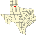
Map of Texas highlighting Briscoe County.svg
Location within the U.S. state of Texas
Texas in United States.svg
Texas's location within the U.S.
Coordinates: 34°32′N101°13′W / 34.53°N 101.21°W / 34.53; -101.21
CountryFlag of the United States.svg United States
StateFlag of Texas.svg  Texas
Founded1892
Named for Andrew Briscoe
Seat Silverton
Largest citySilverton
Area
  Total902 sq mi (2,340 km2)
  Land900 sq mi (2,000 km2)
  Water1.6 sq mi (4 km2)  0.2%
Population
 (2020)
  Total1,435
  Density1.6/sq mi (0.61/km2)
Time zone UTC−6 (Central)
  Summer (DST) UTC−5 (CDT)
Congressional district 13th
Website www.co.briscoe.tx.us

Briscoe County is a county located in the U.S. state of Texas. As of the 2020 census, the population was 1,435. [1] [2] Its county seat is Silverton. [3] The county was created in 1876 and later organized in 1892. [4] It is named for Andrew Briscoe, a soldier during the Texas Revolution.

Contents

At one time, the large JA Ranch, founded by Charles Goodnight and John George Adair, reached into Briscoe County. After he left the JA, Goodnight owned the Quitaque Ranch. The prominent high school football and college coach Gene Mayfield was born in Briscoe County in 1928.

Caprock Canyons State Park and Trailway is located in Briscoe County.

Geography

According to the U.S. Census Bureau, the county has a total area of 902 square miles (2,340 km2), of which 900 square miles (2,300 km2) is land and 1.6 square miles (4.1 km2) (0.2%) is water. [5]

Tule Canyon

Mackenzie Reservoir formed after water on Tule Creek was impounded. In 1972 the project was begun, just east of the site of the slaughter of the Indian ponies by Col. Ranald S. Mackenzie's Fourth Cavalry in 1874. [6]

Major highways

Adjacent counties

Demographics

Historical population
CensusPop.Note
1880 12
1900 1,253
1910 2,16272.5%
1920 2,94836.4%
1930 5,59089.6%
1940 4,056−27.4%
1950 3,528−13.0%
1960 3,5771.4%
1970 2,794−21.9%
1980 2,579−7.7%
1990 1,971−23.6%
2000 1,790−9.2%
2010 1,637−8.5%
2020 1,435−12.3%
U.S. Decennial Census [7]
1850–2010 [8] 2010 [9] 2020 [10]
Briscoe County, Texas - Demographic Profile
(NH = Non-Hispanic)
Race / EthnicityPop 2010 [9] Pop 2020 [10] % 2010% 2020
White alone (NH)1,1631,00871.04%70.24%
Black or African American alone (NH)40172.44%1.18%
Native American or Alaska Native alone (NH)240.12%0.28%
Asian alone (NH)000.00%0.00%
Pacific Islander alone (NH)000.00%0.00%
Some Other Race alone (NH)030.00%0.21%
Mixed Race/Multi-Racial (NH)21351.28%2.44%
Hispanic or Latino (any race)41136825.11%25.64%
Total1,6371,435100.00%100.00%

Note: the US Census treats Hispanic/Latino as an ethnic category. This table excludes Latinos from the racial categories and assigns them to a separate category. Hispanics/Latinos can be of any race.

As of the census [11] of 2000, there were 1,790 people, 724 households, and 511 families residing in the county. The population density was 2 people per square mile (0.77 people/km2). There were 1,006 housing units at an average density of 1 units per square mile (0.39/km2). The racial makeup of the county was 83.35% White, 2.29% Black or African American, 0.39% Native American, 0.06% Asian, 11.45% from other races, and 2.46% from two or more races. 22.74% of the population were Hispanic or Latino of any race.

There were 724 households, out of which 29.30% had children under the age of 18 living with them, 59.30% were married couples living together, 7.60% had a female householder with no husband present, and 29.40% were non-families. 27.90% of all households were made up of individuals, and 16.00% had someone living alone who was 65 years of age or older. The average household size was 2.47 and the average family size was 3.03.

In the county, the population was spread out, with 27.10% under the age of 18, 6.80% from 18 to 24, 22.00% from 25 to 44, 24.80% from 45 to 64, and 19.30% who were 65 years of age or older. The median age was 40 years. For every 100 females there were 95.00 males. For every 100 females age 18 and over, there were 92.80 males.

The median income for a household in the county was $29,917, and the median income for a family was $35,326. Males had a median income of $25,854 versus $17,500 for females. The per capita income for the county was $14,218. About 11.50% of families and 16.00% of the population were below the poverty line, including 23.00% of those under age 18 and 12.50% of those age 65 or over.

Education

Communities

Politics

United States presidential election results for Briscoe County, Texas [12]
Year Republican Democratic Third party
No.%No.%No.%
2020 63988.14%7810.76%81.10%
2016 62584.92%9112.36%202.72%
2012 57882.34%11716.67%71.00%
2008 61774.34%20524.70%80.96%
2004 62076.45%19123.55%00.00%
2000 54470.47%22429.02%40.52%
1996 41646.64%40845.74%687.62%
1992 36037.62%43044.93%16717.45%
1988 46444.27%57454.77%100.95%
1984 53852.90%47146.31%80.79%
1980 56248.87%56148.78%272.35%
1976 28525.47%82373.55%110.98%
1972 64264.20%34934.90%90.90%
1968 41135.49%52845.60%21918.91%
1964 34826.42%96673.35%30.23%
1960 53347.93%57051.26%90.81%
1956 35735.42%64864.29%30.30%
1952 69257.52%50842.23%30.25%
1948 8310.29%69285.75%323.97%
1944 809.66%61574.28%13316.06%
1940 15414.45%91085.37%20.19%
1936 647.01%84992.99%00.00%
1932 424.11%97795.50%40.39%
1928 30146.96%33652.42%40.62%
1924 5311.13%39783.40%265.46%
1920 3911.75%26278.92%319.34%
1916 41.40%26090.91%227.69%
1912 21.29%14895.48%53.23%

See also

Related Research Articles

<span class="mw-page-title-main">Swisher County, Texas</span> County in Texas, United States

Swisher County is a county in the U.S. state of Texas. As of the 2020 census, its population was 6,971. Its county seat is Tulia. The county was created in 1876 and later organized in 1890. It is named for James G. Swisher, a soldier of the Texas Revolution and signer of the Texas Declaration of Independence.

<span class="mw-page-title-main">Randall County, Texas</span> County in Texas, United States

Randall County is a county located in the U.S. state of Texas. As of the 2020 census, its population was 140,753. Its county seat is Canyon. The county was created in 1876 and later organized in 1889. It is named for Horace Randal, a Confederate brigadier general killed at the Battle of Jenkins Ferry. The reason the county name differs from his is because the bill creating the county misspelled Randal's name.

<span class="mw-page-title-main">Oldham County, Texas</span> County in Texas, United States

Oldham County is a county located in the U.S. state of Texas. As of the 2020 census, its population was 1,758. Its county seat is Vega. The county was created in 1876 and organized in 1881. Oldham County is included in the Amarillo, TX Metropolitan Statistical Area.

<span class="mw-page-title-main">Motley County, Texas</span> County in Texas, United States

Motley County is a county located in the U.S. state of Texas. As of the 2020 census, its population was 1,063, making it the 10th-least populous county in Texas. Its county seat is Matador. The county was created in 1876 and organized in 1891. It is named for Junius William Mottley, a signer of the Texas Declaration of Independence. Mottley's name is spelled incorrectly because the bill establishing the county misspelled his name. Motley County was one of 30 prohibition, or entirely dry, counties in Texas, but is now a wet county.

<span class="mw-page-title-main">Lubbock County, Texas</span> County in Texas, United States

Lubbock County is a county located in the U.S. state of Texas. The 2020 census placed the population at 310,639. Its county seat and largest city is Lubbock. The county was created in 1876 and organized in 1891. It is named for Thomas Saltus Lubbock, a Confederate colonel and Texas Ranger.

<span class="mw-page-title-main">Live Oak County, Texas</span> County in Texas, United States

Live Oak County is a county in the U.S. state of Texas. It was named for its native groves of live oak. George West is its county seat. Its population was 11,335 in the 2020 census.

<span class="mw-page-title-main">Howard County, Texas</span> County in Texas, United States

Howard County is a county located in the U.S. state of Texas. At the 2020 census, its population was 34,860. Its county seat is Big Spring. The county was created in 1876 and organized in 1882. It is named for Volney E. Howard, a U.S. Congressman from Texas.

<span class="mw-page-title-main">Hockley County, Texas</span> County in Texas, United States

Hockley County is a county located in the U.S. state of Texas. As of the 2020 census, its population was 21,537. Its county seat is Levelland. The county was created in 1876, but not organized until 1921. It is named for George Washington Hockley, a secretary of war of the Republic of Texas.

<span class="mw-page-title-main">Hall County, Texas</span> County in Texas, United States

Hall County is a county located in the U.S. state of Texas. As of the 2020 census, the population is 2,825. Its county seat is Memphis. The county was created in 1876 and later organized in 1890. It is named for Warren D. C. Hall, a secretary of war for the Republic of Texas.

<span class="mw-page-title-main">Garza County, Texas</span> County in Texas, United States

Garza County is a county located in the U.S. state of Texas. As of the 2020 census, its population was 5,816, of which most of the population were residing in its county seat, and only incorporated municipality, Post. The county was created in 1876 and later organized in 1907. Garza is named for a pioneer Bexar County family, as it was once a part of that county.

<span class="mw-page-title-main">Floyd County, Texas</span> County in Texas, United States

Floyd County is a county in the U.S. state of Texas. As of the 2020 census, its population was 5,402. The seat of the county is Floydada. The county was created in 1876 and later organized in 1890. It is named for Dolphin Ward Floyd, who died on his 32nd birthday, March 6, 1836, defending the Alamo.

<span class="mw-page-title-main">Crosby County, Texas</span> County in Texas, United States

Crosby County is a county located in the U.S. state of Texas. As of the 2020 census, its population was 5,133. The county seat is Crosbyton. The county was founded in 1876 and later organized in 1886. Both the county and its seat are named for Stephen Crosby, a land commissioner in Texas.

<span class="mw-page-title-main">Quitaque, Texas</span> City in Texas, United States

Quitaque is a city in southeastern Briscoe County, Texas, United States. The town lies directly south of Caprock Canyon State Park and is a ranching and farming area in West Texas. The population was 411 at the 2010 census.

<span class="mw-page-title-main">Silverton, Texas</span> City in Texas, United States

Silverton is a city in Briscoe County, Texas, United States. The population was 629 at the 2020 census.

<span class="mw-page-title-main">Ralls, Texas</span> City in Texas, United States

Ralls is a city in Crosby County, Texas, United States. It was named after John Robinson Ralls, who, with the help of W.E. McLaughlin, laid out the townsite in July 1911. As of the 2010 census, it had a population of 1,944, down from 2,252 at the 2000 census. Ralls is surrounded by productive farmlands that primarily produce cotton and grains, with lesser amounts of soybean, sunflower seed, and vegetables.

<span class="mw-page-title-main">Floydada, Texas</span> City in Texas, United States

Floydada is a city in and the county seat of Floyd County, Texas, United States. This rural community lies on the high plains of the Llano Estacado in West Texas and is sometimes referred to as the Pumpkin Capital of Texas. The population was 3,038 at the 2010 census, down from 3,676 at the 2000 census.

<span class="mw-page-title-main">Buffalo Springs, Texas</span> Village in Texas, United States

Buffalo Springs is a village in Lubbock County, Texas, United States. The population was 453 at the 2010 census. It is part of the Lubbock Metropolitan Statistical Area.

<span class="mw-page-title-main">Ransom Canyon, Texas</span> Town in Texas, United States

Ransom Canyon is a town in Lubbock County of West Texas, United States. The population was 1,096 at the 2010 census. It is part of the Lubbock Metropolitan Statistical Area.

<span class="mw-page-title-main">Slaton, Texas</span> City in Texas, United States

Slaton is a city in Lubbock County, Texas, United States. Founded by German immigrants, Slaton was the westernmost German settlement in Texas. The population was 6,121 at the 2010 census. Slaton is part of the Lubbock Metropolitan Statistical Area.

<span class="mw-page-title-main">Texas panhandle</span> Region in Texas, United States

The Texas panhandle is a region of the U.S. state of Texas consisting of the northernmost 26 counties in the state. The panhandle is a square-shaped area bordered by New Mexico to the west and Oklahoma to the north and east. It is adjacent to the Oklahoma Panhandle, land which Texas previously claimed. The 1820 Missouri Compromise declared no slavery would be allowed in states admitted from the Louisiana Purchase above 36°30′ north latitude. Texas was annexed in 1845 from still more westerly land. The Compromise of 1850 removed territory north of this line from Texas, and set the border between the Texas Pandhandle and the New Mexico Territory at the 103rd meridian west. The eastern border at the 100th meridian west was inherited from the Adams–Onís Treaty of 1819, which defined the border between the United States and New Spain. The Handbook of Texas defines the southern border of Swisher County as the southern boundary of the Texas Panhandle region.

References

  1. "U.S. Census Bureau QuickFacts: Briscoe County, Texas". United States Census Bureau. Retrieved January 31, 2022.
  2. "Briscoe County, Texas". United States Census Bureau . Retrieved January 30, 2022.
  3. "Find a County". National Association of Counties. Archived from the original on May 31, 2011. Retrieved June 7, 2011.
  4. "Texas: Individual County Chronologies". Texas Atlas of Historical County Boundaries. The Newberry Library. 2008. Archived from the original on May 13, 2015. Retrieved May 20, 2015.
  5. "2010 Census Gazetteer Files". United States Census Bureau. August 22, 2012. Retrieved April 19, 2015.
  6. "MACKENZIE RESERVOIR". tshaonline.org. June 15, 2010. Retrieved April 29, 2015.
  7. "Decennial Census of Population and Housing by Decade". US Census Bureau.
  8. "Texas Almanac: Population History of Counties from 1850–2010" (PDF). Texas Almanac. Archived (PDF) from the original on October 9, 2022. Retrieved April 19, 2015.
  9. 1 2 "P2 HISPANIC OR LATINO, AND NOT HISPANIC OR LATINO BY RACE - 2010: DEC Redistricting Data (PL 94-171) - Briscoe County, Texas". United States Census Bureau .
  10. 1 2 "P2 HISPANIC OR LATINO, AND NOT HISPANIC OR LATINO BY RACE - 2020: DEC Redistricting Data (PL 94-171) - Briscoe County, Texas". United States Census Bureau .
  11. "U.S. Census website". United States Census Bureau . Retrieved May 14, 2011.
  12. Leip, David. "Dave Leip's Atlas of U.S. Presidential Elections". uselectionatlas.org. Retrieved July 19, 2018.

34°32′N101°13′W / 34.53°N 101.21°W / 34.53; -101.21