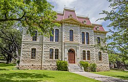
Sutton County | |
---|---|
Coordinates: 30°30′N100°32′W / 30.5°N 100.54°W | |
Country | United States |
State | Texas |
Founded | 1890 |
Named for | John S. Sutton |
Seat | Sonora |
Largest city | Sonora |
Area | |
• Total | 1,454 sq mi (3,770 km2) |
• Land | 1,454 sq mi (3,770 km2) |
• Water | 0.5 sq mi (1 km2) 0.03% |
Population (2020) | |
• Total | 3,372 |
• Density | 2.3/sq mi (0.90/km2) |
Time zone | UTC−6 (Central) |
• Summer (DST) | UTC−5 (CDT) |
Congressional district | 23rd |
Website | www |
Sutton County is a county located on the Edwards Plateau in the U.S. state of Texas. As of the 2020 census, the population was 3,372. [1] Its county seat is Sonora. [2] The county was created in 1887 and organized in 1890. [3] Sutton County is named for John S. Sutton, an officer in the Confederate Army.
According to the U.S. Census Bureau, the county has a total area of 1,454 square miles (3,770 km2), of which 1,454 square miles (3,770 km2) is land and 0.5 square miles (1.3 km2) (0.03%) is water. [15]
Census | Pop. | Note | %± |
---|---|---|---|
1890 | 658 | — | |
1900 | 1,727 | 162.5% | |
1910 | 1,569 | −9.1% | |
1920 | 1,598 | 1.8% | |
1930 | 2,807 | 75.7% | |
1940 | 3,977 | 41.7% | |
1950 | 3,746 | −5.8% | |
1960 | 3,738 | −0.2% | |
1970 | 3,175 | −15.1% | |
1980 | 5,130 | 61.6% | |
1990 | 4,135 | −19.4% | |
2000 | 4,077 | −1.4% | |
2010 | 4,128 | 1.3% | |
2020 | 3,372 | −18.3% | |
U.S. Decennial Census [16] 1850–2010 [17] 2010 [18] 2020 [19] |
Race / Ethnicity (NH = Non-Hispanic) | Pop 2000 [20] | Pop 2010 [18] | Pop 2020 [19] | % 2000 | % 2010 | % 2020 |
---|---|---|---|---|---|---|
White alone (NH) | 1,934 | 1,639 | 1,200 | 47.44% | 39.70% | 35.59% |
Black or African American alone (NH) | 7 | 6 | 6 | 0.17% | 0.15% | 0.18% |
Native American or Alaska Native alone (NH) | 11 | 2 | 5 | 0.27% | 0.05% | 0.15% |
Asian alone (NH) | 7 | 5 | 6 | 0.17% | 0.12% | 0.18% |
Pacific Islander alone (NH) | 0 | 0 | 0 | 0.00% | 0.00% | 0.00% |
Other race alone (NH) | 0 | 7 | 14 | 0.00% | 0.17% | 0.42% |
Mixed race or Multiracial (NH) | 12 | 10 | 48 | 0.29% | 0.24% | 1.42% |
Hispanic or Latino (any race) | 2,106 | 2,459 | 2,093 | 51.66% | 59.57% | 62.07% |
Total | 4,077 | 4,128 | 3,372 | 100.00% | 100.00% | 100.00% |
As of the census [21] of 2000, there were 4,077 people, 1,515 households, and 1,145 families residing in the county. The population density was 3 people per square mile (1.2 people/km2). There were 1,998 housing units at an average density of 1 units per square mile (0.39 units/km2). The racial makeup of the county was 45.28% White, 0.25% Black or African American, 0.42% Native American, 0.17% Asian, 2.27% from other races, and 1.62% from two or more races. 49.99% of the population were Hispanic or Latino of any race.
There were 1,515 households, out of which 38.20% had children under the age of 18 living with them, 63.60% were married couples living together, 7.70% had a female householder with no husband present, and 24.40% were non-families. 22.60% of all households were made up of individuals, and 9.60% had someone living alone who was 65 years of age or older. The average household size was 2.67 and the average family size was 3.15.
In the county, the population was spread out, with 28.80% under the age of 18, 6.70% from 18 to 24, 27.70% from 25 to 44, 24.40% from 45 to 64, and 12.50% who were 65 years of age or older. The median age was 36 years. For every 100 females there were 99.50 males. For every 100 females age 18 and over, there were 96.00 males.
The median income for a household in the county was $34,385, and the median income for a family was $38,143. Males had a median income of $31,193 versus $18,587 for females. The per capita income for the county was $17,105. About 14.10% of families and 18.00% of the population were below the poverty line, including 25.20% of those under age 18 and 16.10% of those age 65 or over.
Sutton County is served by the Sonora Independent School District based in Sonora.
Sutton County is very conservative in national politics. In 2016, it gave 76% of its vote to Republican candidate Donald Trump. It last supported a Democrat in 1964, when Texan Lyndon B. Johnson was the Democratic candidate. However, this was not always the case. In fact, in 1916, the Democratic candidate received 10 times as many votes as the Republican. It hasn't supported a Democrat in Texas gubernatorial elections since 1974, when Dolph Briscoe, the Democrat, carried all but five counties in the state.
Year | Republican | Democratic | Third party(ies) | |||
---|---|---|---|---|---|---|
No. | % | No. | % | No. | % | |
2024 | 1,167 | 83.36% | 228 | 16.29% | 5 | 0.36% |
2020 | 1,222 | 78.48% | 322 | 20.68% | 13 | 0.83% |
2016 | 1,075 | 75.92% | 313 | 22.10% | 28 | 1.98% |
2012 | 1,110 | 74.45% | 369 | 24.75% | 12 | 0.80% |
2008 | 1,189 | 75.35% | 381 | 24.14% | 8 | 0.51% |
2004 | 1,173 | 80.73% | 280 | 19.27% | 0 | 0.00% |
2000 | 1,063 | 69.03% | 468 | 30.39% | 9 | 0.58% |
1996 | 688 | 52.84% | 508 | 39.02% | 106 | 8.14% |
1992 | 687 | 42.99% | 524 | 32.79% | 387 | 24.22% |
1988 | 996 | 63.44% | 571 | 36.37% | 3 | 0.19% |
1984 | 1,251 | 72.69% | 465 | 27.02% | 5 | 0.29% |
1980 | 1,000 | 66.18% | 485 | 32.10% | 26 | 1.72% |
1976 | 831 | 51.65% | 768 | 47.73% | 10 | 0.62% |
1972 | 705 | 73.67% | 245 | 25.60% | 7 | 0.73% |
1968 | 412 | 45.27% | 351 | 38.57% | 147 | 16.15% |
1964 | 357 | 33.97% | 694 | 66.03% | 0 | 0.00% |
1960 | 437 | 47.97% | 474 | 52.03% | 0 | 0.00% |
1956 | 546 | 65.16% | 290 | 34.61% | 2 | 0.24% |
1952 | 581 | 62.34% | 351 | 37.66% | 0 | 0.00% |
1948 | 131 | 21.06% | 433 | 69.61% | 58 | 9.32% |
1944 | 118 | 18.55% | 449 | 70.60% | 69 | 10.85% |
1940 | 84 | 12.79% | 571 | 86.91% | 2 | 0.30% |
1936 | 64 | 13.85% | 398 | 86.15% | 0 | 0.00% |
1932 | 113 | 23.30% | 372 | 76.70% | 0 | 0.00% |
1928 | 290 | 75.92% | 92 | 24.08% | 0 | 0.00% |
1924 | 124 | 46.10% | 143 | 53.16% | 2 | 0.74% |
1920 | 104 | 34.10% | 190 | 62.30% | 11 | 3.61% |
1916 | 13 | 9.09% | 130 | 90.91% | 0 | 0.00% |
1912 | 12 | 13.04% | 62 | 67.39% | 18 | 19.57% |
Wheeler County is a county located in the U.S. state of Texas. As of the 2020 census, its population was 4,990. Its county seat is Wheeler. The county was formed in 1876 and organized in 1879. It is named for Royall Tyler Wheeler, a chief justice of the Texas Supreme Court.
Tyler County is a county located in the U.S. state of Texas. It is in East Texas and its seat is Woodville. As of the 2020 census, its population was 19,798. Tyler County is named for John Tyler, the 10th President of the United States. Despite its name, Tyler County does not contain the city of Tyler, Texas; the latter is located about 140 miles to the north in Smith County.
Trinity County is a county located in the U.S. state of Texas. As of the 2020 census, the population was 13,602. Its county seat is Groveton. The county is named for the Trinity River.
Sherman County is a county located in the U.S. state of Texas. As of the 2020 census, its population was 2,782. Its county seat is Stratford. The county was created in 1876 and organized in 1889. It is named for Sidney Sherman, who fought in the Texas Revolution. Though both Sherman County and Sherman, Texas, are named for the same person, the city of Sherman is located in Grayson County, about 430 miles to the southeast.
Shackelford County is a county located in the U.S. state of Texas. As of the 2020 census, its population was 3,105. Its county seat is Albany. The county was created in 1858 and later organized in 1874. Shackelford is named for Dr. Jack Shackelford, a Virginia physician who equipped soldiers at his own expense to fight in the Texas Revolution.
Schleicher County is a county located on the Edwards Plateau in the U.S. state of Texas. As of the 2020 census, its population was 2,451. Its county seat is Eldorado. The county was created in 1887 and organized in 1901. It is named for Gustav Schleicher, a German immigrant who became a surveyor and politician.
Mitchell County is a county in the U.S. state of Texas. As of the 2020 census, its population was 8,990. Its county seat is Colorado City. The county was created in 1876 and organized in 1881. It is named for Asa and Eli Mitchell, two early settlers and soldiers in the Texas Revolution.
Menard County is a county located on the Edwards Plateau in the U.S. state of Texas. As of the 2020 census, its population was 1,962. The county seat is Menard. The county was created in 1858 and later organized in 1871. It is named for Michel Branamour Menard, the founder of Galveston, Texas.
Hopkins County is a county located in the U.S. state of Texas. As of the 2020 census, its population was 36,787. Its county seat is Sulphur Springs. Hopkins County is named for the family of David Hopkins, an early settler in the area. Hopkins County comprises the Sulphur Springs, TX Micropolitan Statistical Area. Hopkins County was once known as the Dairy Capital of Texas. Although dairy farms declined in the area in the late 1990s there are still a number of these located there. The Southwest Dairy Museum is located in Sulphur Springs.
Edwards County is a county located on the Edwards Plateau in the U.S. state of Texas. As of the 2020 census its population was 1,422. The county seat is Rocksprings. The county was created in 1858 and organized in 1883. It is named for Haden Edwards, an early settler of Nacogdoches, Texas. The Edwards Aquifer and Edwards Plateau are named after the county by reason of their locations.
Crockett County is a county located on the Edwards Plateau in the U.S. state of Texas. As of the 2020 census, its population was 3,098. The county seat is Ozona. The county was founded in 1875 and later organized in 1891. It is named in honor of Davy Crockett, the legendary frontiersman who died at the Battle of the Alamo.
Cooke County is a county in the U.S. state of Texas. At the 2020 census, its population was 41,668. The county seat is Gainesville. The county was founded in 1848 and organized the next year. It is named for William Gordon Cooke, a soldier during the Texas Revolution. It is a part of the Texoma region.
Collingsworth County is a county in the U.S. state of Texas. As of the 2020 census, its population was 2,652. Its county seat is Wellington. The county was created in 1876 and later organized in 1890. It is named for James Collinsworth, a signer of the Texas Declaration of Independence and first chief justice of the Republic of Texas. Collingsworth County was one of 30 prohibition, or entirely dry, counties in Texas, but a vote in 2017 changed this law.
Childress County is a county located in the U.S. state of Texas. As of the 2020 census, its population was 6,664. The county seat is Childress. The county was created in 1876 and later organized in 1887. It is named for George Campbell Childress, the author of the Texas Declaration of Independence.
Callahan County is a county located in the U.S. state of Texas. As of the 2020 census, the population was 13,708. Its county seat is Baird. The county was founded in 1858 and later organized in 1877. It is named for James Hughes Callahan, an American soldier in the Texas Revolution. Callahan County is included in the Abilene, Texas metropolitan statistical area.
Burleson County is a county located in the U.S. state of Texas. As of the 2020 census, the population was 17,642. Its county seat is Caldwell. The county is named for Edward Burleson, a general and statesman of the Texas Revolution.
Briscoe County is a county located in the U.S. state of Texas. As of the 2020 census, the population was 1,435. Its county seat is Silverton. The county was created in 1876 and later organized in 1892. It is named for Andrew Briscoe, a soldier during the Texas Revolution.
Eldorado is the only city in and the county seat of Schleicher County, Texas, United States. The population was 1,574 at the 2020 census. Eldorado is located on U.S. Highway 277, some 21 miles (34 km) north of Sonora and 43 miles (69 km) south of San Angelo, Texas.
Sonora is a city in and the county seat of Sutton County, Texas, United States. The population was 2,502 at the 2020 census.
Kress is a city in Swisher County, Texas, United States. The population was 596 at the 2020 census.
Media related to Sutton County, Texas at Wikimedia Commons