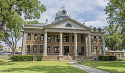
Mason County | |
---|---|
Coordinates: 30°43′N99°13′W / 30.72°N 99.22°W | |
Country | United States |
State | Texas |
Founded | 1858 |
Named for | Fort Mason |
Seat | Mason |
Largest city | Mason |
Area | |
• Total | 932 sq mi (2,410 km2) |
• Land | 929 sq mi (2,410 km2) |
• Water | 3.4 sq mi (9 km2) 0.4% |
Population (2020) | |
• Total | 3,953 |
• Density | 4.2/sq mi (1.6/km2) |
Time zone | UTC−6 (Central) |
• Summer (DST) | UTC−5 (CDT) |
Congressional district | 11th |
Website | www |
Mason County is a rural county located on the Edwards Plateau in the U.S. state of Texas. At the 2020 census, its population was 3,953. [1] Its county seat is Mason. [2] The county is named for Fort Mason, which was located in the county.
According to the U.S. Census Bureau, the county has a total area of 932 square miles (2,410 km2), of which 929 square miles (2,410 km2) is land and 3.4 square miles (8.8 km2) (0.4%) is water. [23]
Census | Pop. | Note | %± |
---|---|---|---|
1860 | 630 | — | |
1870 | 678 | 7.6% | |
1880 | 2,655 | 291.6% | |
1890 | 5,180 | 95.1% | |
1900 | 5,573 | 7.6% | |
1910 | 5,683 | 2.0% | |
1920 | 4,824 | −15.1% | |
1930 | 5,511 | 14.2% | |
1940 | 5,378 | −2.4% | |
1950 | 4,945 | −8.1% | |
1960 | 3,780 | −23.6% | |
1970 | 3,356 | −11.2% | |
1980 | 3,683 | 9.7% | |
1990 | 3,423 | −7.1% | |
2000 | 3,738 | 9.2% | |
2010 | 4,012 | 7.3% | |
2020 | 3,953 | −1.5% | |
U.S. Decennial Census [24] 1850–2010 [25] 2010 [26] 2020 [27] |
Race / Ethnicity (NH = Non-Hispanic) | Pop 2000 [28] | Pop 2010 [26] | Pop 2020 [27] | % 2000 | % 2010 | % 2020 |
---|---|---|---|---|---|---|
White alone (NH) | 2,912 | 3,092 | 2,948 | 77.90% | 77.07% | 74.58% |
Black or African American alone (NH) | 5 | 14 | 4 | 0.13% | 0.35% | 0.10% |
Native American or Alaska Native alone (NH) | 16 | 11 | 0 | 0.43% | 0.27% | 0.00% |
Asian alone (NH) | 2 | 7 | 2 | 0.05% | 0.17% | 0.05% |
Pacific Islander alone (NH) | 0 | 0 | 0 | 0.00% | 0.00% | 0.00% |
Other race alone (NH) | 5 | 4 | 16 | 0.13% | 0.10% | 0.40% |
Mixed race or Multiracial (NH) | 15 | 20 | 100 | 0.40% | 0.50% | 2.53% |
Hispanic or Latino (any race) | 783 | 864 | 883 | 20.95% | 21.54% | 22.34% |
Total | 3,738 | 4,012 | 3,953 | 100.00% | 100.00% | 100.00% |
At the 2000 census, [29] there were 3,738 people, 1,607 households and 1,110 families residing in the county. The population density was 4 people per square mile (1.5 people/km2). There were 2,372 housing units at an average density of 2 units per square mile (0.77/km2). The racial makeup of the county was 91.60% White, 0.13% Black or African American, 0.62% Native American, 0.05% Asian, 0.03% Pacific Islander, 5.75% from other races, and 1.82% from two or more races. 20.95% of the population were Hispanic or Latino of any race.
There were 1,607 households, of which 25.90% had children under the age of 18 living with them, 59.10% were married couples living together, 7.70% had a female householder with no husband present, and 30.90% were non-families. 29.20% of all households were made up of individuals, and 17.90% had someone living alone who was 65 years of age or older. The average household size was 2.31 and the average family size was 2.83.
22.40% of the population were under the age of 18, 4.70% from 18 to 24, 20.70% from 25 to 44, 28.80% from 45 to 64, and 23.50% who were 65 years of age or older. The median age was 47 years. For every 100 females there were 92.40 males. For every 100 females age 18 and over, there were 87.60 males.
The median household income was $30,921 and the median family income was $39,360. Males had a median income of $28,125 compared with $20,000 for females. The per capita income was $20,931. About 10.10% of families and 13.20% of the population were below the poverty line, including 20.50% of those under age 18 and 13.30% of those age 65 or over.
Year | Republican | Democratic | Third party(ies) | |||
---|---|---|---|---|---|---|
No. | % | No. | % | No. | % | |
2020 | 1,991 | 80.48% | 457 | 18.47% | 26 | 1.05% |
2016 | 1,656 | 80.51% | 354 | 17.21% | 47 | 2.28% |
2012 | 1,565 | 79.52% | 380 | 19.31% | 23 | 1.17% |
2008 | 1,544 | 72.80% | 546 | 25.74% | 31 | 1.46% |
2004 | 1,600 | 77.03% | 459 | 22.10% | 18 | 0.87% |
2000 | 1,352 | 75.07% | 417 | 23.15% | 32 | 1.78% |
1996 | 949 | 54.70% | 618 | 35.62% | 168 | 9.68% |
1992 | 776 | 45.06% | 570 | 33.10% | 376 | 21.84% |
1988 | 975 | 58.91% | 671 | 40.54% | 9 | 0.54% |
1984 | 1,168 | 67.01% | 570 | 32.70% | 5 | 0.29% |
1980 | 966 | 59.59% | 630 | 38.86% | 25 | 1.54% |
1976 | 805 | 49.09% | 814 | 49.63% | 21 | 1.28% |
1972 | 1,096 | 73.71% | 369 | 24.82% | 22 | 1.48% |
1968 | 789 | 51.98% | 560 | 36.89% | 169 | 11.13% |
1964 | 590 | 38.44% | 941 | 61.30% | 4 | 0.26% |
1960 | 833 | 58.79% | 575 | 40.58% | 9 | 0.64% |
1956 | 885 | 63.67% | 504 | 36.26% | 1 | 0.07% |
1952 | 1,069 | 63.71% | 606 | 36.11% | 3 | 0.18% |
1948 | 498 | 36.73% | 836 | 61.65% | 22 | 1.62% |
1944 | 420 | 28.07% | 822 | 54.95% | 254 | 16.98% |
1940 | 634 | 37.25% | 1,065 | 62.57% | 3 | 0.18% |
1936 | 359 | 31.30% | 787 | 68.61% | 1 | 0.09% |
1932 | 309 | 27.08% | 828 | 72.57% | 4 | 0.35% |
1928 | 807 | 76.64% | 244 | 23.17% | 2 | 0.19% |
1924 | 171 | 23.82% | 384 | 53.48% | 163 | 22.70% |
1920 | 269 | 39.97% | 304 | 45.17% | 100 | 14.86% |
1916 | 157 | 27.30% | 386 | 67.13% | 32 | 5.57% |
1912 | 152 | 17.21% | 472 | 53.45% | 259 | 29.33% |
Wilson County is a county located in the U.S. state of Texas. As of the 2020 census, its population was 49,753. Its county seat is Floresville. The county is named after James Charles Wilson. Wilson County is part of the San Antonio–New Braunfels, Texas, metropolitan statistical area.
San Saba County is a county located on the Edwards Plateau in western Central Texas, United States. As of the 2020 census, its population was 5,730. Its county seat is San Saba. The county is named after the San Saba River, which flows through the county.
Reagan County is a county on the Edwards Plateau in the U.S. state of Texas. As of the 2020 census, its population was 3,385. The county seat is Big Lake. The county is named after John Henninger Reagan (1818–1905), who was the postmaster general of the Confederate States and also a U.S. senator, U.S. representative, and first chairman of the Railroad Commission of Texas.
Pecos County is a county located in the U.S. state of Texas. As of the 2020 census, its population was 15,193. The county seat is Fort Stockton. The county was created in 1871 and organized in 1875. It is named for the Pecos River. It is one of the nine counties that comprise the Trans-Pecos region of West Texas.
Menard County is a county located on the Edwards Plateau in the U.S. state of Texas. As of the 2020 census, its population was 1,962. The county seat is Menard. The county was created in 1858 and later organized in 1871. It is named for Michel Branamour Menard, the founder of Galveston, Texas.
McCulloch County is a county located on the Edwards Plateau in the U.S. state of Texas. At the 2020 census, its population was 7,630. Its county seat is Brady. The county was created in 1856 and later organized in 1876. It is named for Benjamin McCulloch, a famous Texas Ranger and Confederate general.
Llano County is a county located on the Edwards Plateau in the U.S. state of Texas. As of the 2020 census, its population was 21,243. Its county seat is Llano, and the county is named for the Llano River.
Limestone County is a county in the U.S. state of Texas. As of the 2020 census, its population was 22,146. Its county seat is Groesbeck. The county was created in 1846.
Kendall County is a county located on the Edwards Plateau in the U.S. state of Texas. In 2020 census, its population was 44,279. Its county seat is Boerne. The county is named for George Wilkins Kendall, a journalist and Mexican–American War correspondent.
Gillespie County is a county located on the Edwards Plateau in the U.S. state of Texas. As of the 2020 census, its population was 26,725. The county seat is Fredericksburg. It is located in the heart of the rural Texas Hill Country in Central Texas. Gillespie is named for Robert Addison Gillespie, a soldier in the Mexican–American War. It is known as the birthplace of 36th president of the United States of America Lyndon B. Johnson.
Falls County is a county in the U.S. state of Texas. As of the 2020 census, its population was 16,968. The county seat is Marlin. It is named for the original 10-foot-tall waterfall on the Brazos River, which existed until the river changed course during a storm in 1866. The present falls is two miles northeast of the original falls, at the Falls on the Brazos Park, a camping site only a few miles out of Marlin on Farm to Market Road 712.
Edwards County is a county located on the Edwards Plateau in the U.S. state of Texas. As of the 2020 census its population was 1,422. The county seat is Rocksprings. The county was created in 1858 and organized in 1883. It is named for Haden Edwards, an early settler of Nacogdoches, Texas. The Edwards Aquifer and Edwards Plateau are named after the county by reason of their locations.
Crockett County is a county located on the Edwards Plateau in the U.S. state of Texas. As of the 2020 census, its population was 3,098. The county seat is Ozona. The county was founded in 1875 and later organized in 1891. It is named in honor of Davy Crockett, the legendary frontiersman who died at the Battle of the Alamo.
Concho County is a county located on the Edwards Plateau in the U.S. state of Texas. At the 2020 census, the population was 3,303. Its county seat is Paint Rock. The county was founded in 1858 and later organized in 1879. It is named for the Concho River.
Comanche County is a county located on the Edwards Plateau in Central Texas. As of the 2020 census, its population was 13,594. The county seat is Comanche. The county was founded in 1856 and is named for the Comanche Native American tribe.
Brown County is a county in west-central Texas. As of the 2020 census, the population was 38,095. Its county seat is Brownwood. The county was founded in 1856 and organized in 1858. It is named for Henry Stevenson Brown, a commander at the Battle of Velasco, an early conflict between Texians and Mexicans.
Blanco County is a United States county located in the U.S. state of Texas. It is located in Central Texas and its county seat is Johnson City.
Mason is a city in, and the county seat of, Mason County, Texas, United States. The city is an agricultural community on Comanche Creek southwest of Mason Mountain, on the Edwards Plateau and part of the Llano Uplift. Its population was 2,121 at the 2020 census.
Runnels County is a county located in the U.S. state of Texas. As of the 2020 census, its population was 9,900. Its county seat is Ballinger. The county was created in 1858 and later organized in 1880. It is named for Hiram G. Runnels, a Texas state legislator.
Loyal Valley is an unincorporated farming and ranching community in the southwestern corner of Mason County, Texas, United States, that was established in 1858, and is 6 miles (9.7 km) north of Cherry Spring. The community is located near Cold Spring Creek, which runs east for 7.5 miles (12.1 km) to its mouth on Marschall Creek in Llano County, just east of Loyal Valley. The community is located on the old Pinta Trail. As of 2000, the population was 50.