Knox County, Texas

Last updated

Knox County
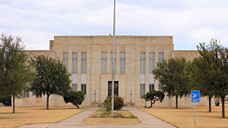
Knox County Texas Courthouse 2015.jpg
The Knox County Courthouse in Benjamin
Map of Texas highlighting Knox County.svg
Location within the U.S. state of Texas
Texas in United States.svg
Texas's location within the U.S.
Coordinates: 33°37′N99°44′W / 33.61°N 99.74°W / 33.61; -99.74
CountryFlag of the United States.svg United States
StateFlag of Texas.svg  Texas
Founded1886
Named for Henry Knox
Seat Benjamin
Largest city Munday
Area
  Total855 sq mi (2,210 km2)
  Land851 sq mi (2,200 km2)
  Water4.9 sq mi (13 km2)  0.6%
Population
 (2020)
  Total3,353
  Density3.9/sq mi (1.5/km2)
Time zone UTC−6 (Central)
  Summer (DST) UTC−5 (CDT)
Congressional district 13th
Website www.knoxcountytexas.org

Knox County is a county located in the U.S. state of Texas. As of the 2020 census, its population was 3,353. [1] Its county seat is Benjamin. [2] The county was created in 1858 and later organized in 1886. [3] It is named for Henry Knox, an American Revolutionary War general. [4]

Contents

Geography

According to the U.S. Census Bureau, the county has a total area of 855 sq mi (2,210 km2), of which 4.9 square miles (13 km2) (0.6%) are covered by water. [5]

Major highways

Adjacent counties

Notable geographic features

Demographics

Historical population
CensusPop.Note
1880 77
1890 1,1341,372.7%
1900 2,322104.8%
1910 9,625314.5%
1920 9,240−4.0%
1930 11,36823.0%
1940 10,090−11.2%
1950 10,082−0.1%
1960 7,857−22.1%
1970 5,972−24.0%
1980 5,329−10.8%
1990 4,837−9.2%
2000 4,253−12.1%
2010 3,719−12.6%
2020 3,353−9.8%
U.S. Decennial Census [6]
1850–2010 [7] 2010 [8] 2020 [9]
Knox County, Texas - Demographic Profile
(NH = Non-Hispanic)
Race / EthnicityPop 2010 [8] Pop 2020 [9] % 2010% 2020
White alone (NH)2,3471,93563.11%57.71%
Black or African American alone (NH)2091465.62%4.35%
Native American or Alaska Native alone (NH)1480.38%0.24%
Asian alone (NH)7240.19%0.72%
Pacific Islander alone (NH)130.03%0.09%
Some Other Race alone (NH)450.11%0.15%
Mixed Race/Multi-Racial (NH)361020.97%3.04%
Hispanic or Latino (any race)1,1011,13029.60%33.70%
Total3,7193,353100.00%100.00%

Note: the US Census treats Hispanic/Latino as an ethnic category. This table excludes Latinos from the racial categories and assigns them to a separate category. Hispanics/Latinos can be of any race.

As of the census [10] of 2000, 4,253 people, 1,690 households, and 1,166 were families residing in the county. The population density was 5 people/sq mi (1.9 people/km2). The 2,129 housing units had an average density of two units per square mile (0.77 units/km2). The racial makeup of the county was 74.35% White, 6.91% African American, 1.08% Native American, 0.24% Asian, 0.09% Pacific Islander, 14.77% from other races, and 2.56% from two or more races. About 25.09% of the population was Hispanic or Latino of any race.

Of the 1,690 households, 30.7% had children under 18 living with them, 56.0% were married couples living together, 9.9% had a female householder with no husband present, and 31.0% were not families. About 29.6% of all households were made up of individuals, and 17.9% had someone living alone who was 65 or older. The average household size was 2.44, and the average family size was 3.02.

In the county, the age distribution was 27.7% under the age of 18, 5.6% from 18 to 24, 22.9% from 25 to 44, 21.0% from 45 to 64, and 22.7% who were 65 or older. The median age was 40 years. For every 100 females, there were 89.40 males. For every 100 females age 18 and over, there were 87.80 males.

The median income for a household in the county was $25,453, and for a family was $30,602. Males had a median income of $25,571 versus $20,865 for females. The per capita income for the county was $13,443. About 17.1% of families and 22.9% of the population were below the poverty line, including 35.2% of those under age 18 and 15.2% of those age 65 or over.
Education

These school districts serve Knox County: [11]

Goree Independent School District formerly served sections of the county. [12] On July 1, 2003, it merged into Munday CISD. [13]

The county is in the service area of Vernon College. [14]

Bobby Boatright Memorial Music Camp

The city of Goree in Knox County is the site of the annual Bobby Boatright Memorial Music Camp, an event for aspiring Western Swing musicians of all ages to showcase their musical talents. The camp's namesake was a fiddle player who was originally from Goree. The camp was profiled in a story that aired on July 21, 2010, on National Public Radio's Morning Edition program. [15]

Communities

Cities

Town

Unincorporated communities

Politics

Knox County is represented in the Texas House of Representatives by the Republican James Frank, a businessman from Wichita Falls. The 1932 Texas Republican gubernatorial nominee, Orville Bullington, resided in Knox County and served as county attorney early in his career.

United States presidential election results for Knox County, Texas [16]
Year Republican Democratic Third party
No.%No.%No.%
2020 1,18081.04%26518.20%110.76%
2016 1,07878.86%24718.07%423.07%
2012 1,16076.82%33221.99%181.19%
2008 98672.08%36726.83%151.10%
2004 1,08169.65%46429.90%70.45%
2000 94760.09%61739.15%120.76%
1996 59938.97%78551.07%1539.95%
1992 52128.71%85447.05%44024.24%
1988 76542.93%1,01356.85%40.22%
1984 1,02752.61%92147.18%40.20%
1980 78339.79%1,16359.10%221.12%
1976 55126.75%1,49872.72%110.53%
1972 1,14863.78%63835.44%140.78%
1968 58027.27%1,22257.45%32515.28%
1964 43919.81%1,77380.01%40.18%
1960 72934.75%1,36565.06%40.19%
1956 83539.76%1,26260.10%30.14%
1952 1,03339.88%1,55660.08%10.04%
1948 1577.82%1,79289.24%592.94%
1944 1567.28%1,78583.33%2019.38%
1940 25312.96%1,69987.04%00.00%
1936 1718.55%1,82391.15%60.30%
1932 1025.98%1,60093.79%40.23%
1928 99255.70%78444.02%50.28%
1924 45523.51%1,39972.30%814.19%
1920 15915.44%77375.05%989.51%
1916 646.07%88483.79%10710.14%
1912 323.74%64375.12%18121.14%

See also

Related Research Articles

<span class="mw-page-title-main">Wilbarger County, Texas</span> County in Texas, United States

Wilbarger County is a county located in the North Texas region of the U.S. state of Texas. As of the 2020 census, the population was 12,887. The county seat is Vernon. The county was created in 1858 and later organized in 1881. Wilbarger is named for Josiah Pugh Wilbarger and Mathias Wilbarger, two early settlers.

<span class="mw-page-title-main">Walker County, Texas</span> County in Texas, United States

Walker County is a county located in the east central section of the U.S. state of Texas. As of the 2020 census, its population was 76,400. Its county seat is Huntsville. Initially, Walker County was named for Robert J. Walker, a legislator from Mississippi who introduced into the United States Congress the resolution to annex Texas. Walker later supported the U.S. during its Civil War and earned some enmity for it. In order to keep the county's name, the state renamed it for Samuel H. Walker, a Texas Ranger and soldier in the United States Army.

<span class="mw-page-title-main">Titus County, Texas</span> County in Texas, United States

Titus County is a county located in the northeastern region of the U.S. state of Texas. As of the 2020 census, its population was 31,247. Its county seat is Mount Pleasant. The county is named for Andrew Jackson Titus, an early settler. Titus County comprises the Mount Pleasant micropolitan statistical area.

<span class="mw-page-title-main">Throckmorton County, Texas</span> County in Texas, United States

Throckmorton County is a county located in the U.S. state of Texas. As of the 2020 census, its population was 1,440. Its county seat is Throckmorton. The county was created in 1858 and later organized in 1879. It is named for William Throckmorton, an early Collin County settler. Throckmorton County is one of five remaining prohibition, or entirely dry, counties in Texas.

<span class="mw-page-title-main">Shelby County, Texas</span> County in Texas, United States

Shelby County is a county located in the far eastern portion of the U.S. state of Texas. As of the 2020 census, its population was 24,022. Its county seat is Center. The county was established in 1835 as a municipality of Mexico and organized as a county in 1837. It is named for Isaac Shelby, a soldier in the American Revolution who became the first governor of Kentucky.

<span class="mw-page-title-main">Shackelford County, Texas</span> County in Texas, United States

Shackelford County is a county located in the U.S. state of Texas. As of the 2020 census, its population was 3,105. Its county seat is Albany. The county was created in 1858 and later organized in 1874. Shackelford is named for Dr. Jack Shackelford, a Virginia physician who equipped soldiers at his own expense to fight in the Texas Revolution.

<span class="mw-page-title-main">San Jacinto County, Texas</span> County in Texas, United States

San Jacinto County is a county in the U.S. state of Texas. As of the 2020 census, its population was 27,402. Its county seat is Coldspring. The county's name comes from the Battle of San Jacinto which secured Texas' independence from Mexico and established a republic in 1836.

<span class="mw-page-title-main">Robertson County, Texas</span> County in Texas, United States

Robertson County is a county in the U.S. state of Texas. As of the 2020 census, its population was 16,757. Its county seat is Franklin. The county was created in 1837 and organized the following year. It is named for Sterling C. Robertson, an early settler who signed the Texas Declaration of Independence.

<span class="mw-page-title-main">Red River County, Texas</span> County in Texas, United States

Red River County is a county in the U.S. state of Texas. As of the 2020 census, its population was 11,587. Its county seat is Clarksville. The county was created in 1835 and organized in 1837. It is named for the Red River, which forms its northern boundary. Red River County was the birthplace of John Nance Garner, 32nd Vice President of the United States.

<span class="mw-page-title-main">Panola County, Texas</span> County in Texas, United States

Panola County is a county located in the U.S. state of Texas. As of the 2020 census, its population was 22,491. The county seat is Carthage. Located in East Texas and originally developed for cotton plantations, the county's name is derived from a Choctaw word for cotton.

<span class="mw-page-title-main">Hopkins County, Texas</span> County in Texas, United States

Hopkins County is a county located in the U.S. state of Texas. As of the 2020 census, its population was 36,787. Its county seat is Sulphur Springs. Hopkins County is named for the family of David Hopkins, an early settler in the area. Hopkins County comprises the Sulphur Springs, TX Micropolitan Statistical Area. Hopkins County was once known as the Dairy Capital of Texas. Although dairy farms declined in the area in the late 1990s there are still a number of these located there. The Southwest Dairy Museum is located in Sulphur Springs.

<span class="mw-page-title-main">Haskell County, Texas</span> County in Texas, United States

Haskell County is a county located in the U.S. state of Texas. As of the 2020 census, its population was 5,416. The county seat is Haskell. The county was created in 1858 and later organized in 1885. It is named for Charles Ready Haskell, who was killed in the Goliad massacre.

<span class="mw-page-title-main">Foard County, Texas</span> County in Texas, United States

Foard County is a county located in the U.S. state of Texas. As of the 2020 census, its population was 1,095. Its county seat is Crowell, which is also the county's only incorporated community. The county is named for Robert Levi Foard, an attorney who served as a major with the Confederate Army, in the American Civil War.

<span class="mw-page-title-main">Fannin County, Texas</span> County in Texas, United States

Fannin County is a county in the far northeast of the U.S. state of Texas, on the border with Oklahoma. As of the 2020 census, its population was 35,662. The county seat is Bonham.

<span class="mw-page-title-main">Baylor County, Texas</span> County in Texas, United States

Baylor County is a county located in the U.S. state of Texas. As of the 2020 census, its population was 3,465. Its county seat is Seymour.

<span class="mw-page-title-main">Weinert, Texas</span> City in Texas, United States

Weinert is a city in Haskell County, Texas, United States. The population was 172 at the 2010 census.

<span class="mw-page-title-main">Goree, Texas</span> City in the United States

Goree is a city in Knox County, Texas, United States. The population was 203 at the 2010 census, down from 321 at the 2000 census. A July 1, 2013 U.S. Census Bureau estimate placed the population at 207.

<span class="mw-page-title-main">Knox City, Texas</span> Town in Texas, United States

Knox City is a town in Knox County, Texas, United States. The population was 1,119 at the 2019 census.

<span class="mw-page-title-main">Munday, Texas</span> City in Texas, United States

Munday is a city in Knox County, Texas, United States. The population was 1,246 at the 2020 census.

Goree Independent School District was a public school district based in Goree, Texas (USA).

References

  1. "Knox County, Texas". United States Census Bureau . Retrieved February 23, 2021.
  2. "Find a County". National Association of Counties. Archived from the original on May 31, 2011. Retrieved June 7, 2011.
  3. "Texas: Individual County Chronologies". Texas Atlas of Historical County Boundaries. The Newberry Library. 2008. Retrieved May 24, 2015.
  4. Gannett, Henry (1905). The Origin of Certain Place Names in the United States. Government Printing Office. p. 177.
  5. "2010 Census Gazetteer Files". United States Census Bureau. August 22, 2012. Retrieved May 2, 2015.
  6. "Decennial Census of Population and Housing by Decades". US Census Bureau.
  7. "Texas Almanac: Population History of Counties from 1850–2010" (PDF). Texas Almanac. Archived (PDF) from the original on October 9, 2022. Retrieved May 2, 2015.
  8. 1 2 "P2 HISPANIC OR LATINO, AND NOT HISPANIC OR LATINO BY RACE - 2010: DEC Redistricting Data (PL 94-171) - Knox County, Texas". United States Census Bureau .
  9. 1 2 "P2 HISPANIC OR LATINO, AND NOT HISPANIC OR LATINO BY RACE - 2020: DEC Redistricting Data (PL 94-171) - Knox County, Texas". United States Census Bureau .
  10. "U.S. Census website". United States Census Bureau . Retrieved May 14, 2011.
  11. "2020 CENSUS - SCHOOL DISTRICT REFERENCE MAP: Knox County, TX" (PDF). U.S. Census Bureau. Archived (PDF) from the original on October 9, 2022. Retrieved June 29, 2022. - Text list
  12. "Knox County". Texas Education Agency. March 11, 2001. Archived from the original on March 11, 2001. Retrieved July 1, 2022.
  13. "CONSOLIDATIONS, ANNEXATIONS AND NAME CHANGES FOR TEXAS PUBLIC SCHOOLS" (PDF). Texas Education Agency. Archived (PDF) from the original on October 9, 2022. Retrieved July 1, 2022.
  14. Texas Education Code, Sec. 130.207. VERNON REGIONAL JUNIOR COLLEGE DISTRICT SERVICE AREA.
  15. Highlights, transcript, and audio links to NPR story on the Bobby Boatright Memorial Music Camp that aired 07/21/10
  16. Leip, David. "Dave Leip's Atlas of U.S. Presidential Elections". uselectionatlas.org. Retrieved July 26, 2018.

33°37′N99°44′W / 33.61°N 99.74°W / 33.61; -99.74