Rhineland, Texas

Last updated

Rhineland, Texas
Rhineland Texas St Josephs Church.jpg
St Joseph's Church in Rhineland
Relief map of Texas.png
Red pog.svg
Rhineland
Usa edcp relief location map.png
Red pog.svg
Rhineland
Coordinates: 33°31′47″N99°39′18″W / 33.52972°N 99.65500°W / 33.52972; -99.65500
CountryFlag of the United States.svg  United States
StateFlag of Texas.svg  Texas
County Knox
Region Brazos River basin
Established1895
Elevation
[1]
1,404 ft (428 m)
Population
 (2000)
  Total100
Time zone UTC-6 (CST)
ZIP code
76371
Area code 940
Website Rhineland, Texas from the Handbook of Texas Online

Rhineland is an unincorporated community in Knox County, Texas, United States. According to the Handbook of Texas , the community had an estimated population of 100 in 2000. [2]

Contents

Geography

Rhineland is located within the physiographic region known as the Texas Rolling Plains, approximately 1 mi (1.6 km) south of the Brazos River at the intersection of Farm-to-Market roads 267 and 2534 in southeastern Knox County. It is situated 9 mi (14 km) to the southeast of the county seat of Benjamin, 6 mi (9.7 km) north of Munday, and 85 mi (137 km) north of Abilene. [3]

Climate

According to the Köppen climate classification, Rhineland enjoys a semiarid climate, BSk on climate maps. [4]

History

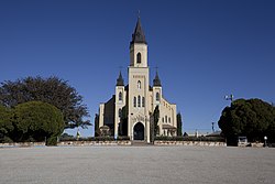
The community was officially established on February 1, 1895, when the land contract between J.C. League and German-born Catholics – Father Joseph R. Reisdorff and Hugh Herchenbach – was notarized. [2] The 12,000-acre (49 km2) plot was advertised as a colony for German Catholics and was named after the Rhineland region in Germany. The first land sold was to John Bruckner at $8 an acre. John bought around 160 acres, but had 8,000 acres to choose from. The land he chose sits near the corner of FM 267 and CR 4260. The Rhineland Common School District was organized in 1898, with the first schoolhouse being built the following year. A larger, brick school building was constructed in 1926 that provided public education through high school. A number of students attended a local parochial school.

By 1950, Rhineland had around 75 residents. Over the years, the community experienced a slight rise in population, but the number of businesses declined. Rhineland's school district later consolidated with nearby Munday. In 1980, the estimated number of inhabitants in Rhineland was 196. That figure had fallen to 100 by 2000. [2]

Education

Public education in the community of Rhineland is provided by the Munday Consolidated Independent School District.

See also

Related Research Articles

<span class="mw-page-title-main">Throckmorton County, Texas</span> County in Texas, United States

Throckmorton County is a county located in the U.S. state of Texas. As of the 2020 census, its population was 1,440. Its county seat is Throckmorton. The county was created in 1858 and later organized in 1879. It is named for William Throckmorton, an early Collin County settler. Throckmorton County is one of five remaining prohibition, or entirely dry, counties in Texas.

<span class="mw-page-title-main">Knox County, Texas</span> County in Texas, United States

Knox County is a county located in the U.S. state of Texas. As of the 2020 census, its population was 3,353. Its county seat is Benjamin. The county was created in 1858 and later organized in 1886. It is named for Henry Knox, an American Revolutionary War general.

<span class="mw-page-title-main">Weinert, Texas</span> City in Texas, United States

Weinert is a city in Haskell County, Texas, United States. The population was 172 at the 2010 census.

<span class="mw-page-title-main">Benjamin, Texas</span> City in Texas, United States

Benjamin is a city in and the county seat of Knox County, Texas, United States. Its population was 258 at the 2010 census.

<span class="mw-page-title-main">Goree, Texas</span> City in the United States

Goree is a city in Knox County, Texas, United States. The population was 203 at the 2010 census, down from 321 at the 2000 census. A July 1, 2013 U.S. Census Bureau estimate placed the population at 207.

<span class="mw-page-title-main">Knox City, Texas</span> Town in Texas, United States

Knox City is a town in Knox County, Texas, United States. The population was 1,119 at the 2019 census.

<span class="mw-page-title-main">Munday, Texas</span> City in Texas, United States

Munday is a city in Knox County, Texas, United States. The population was 1,246 at the 2020 census.

Vanderpool is a small unincorporated community in Bandera County in the Texas Hill Country, which is part of the Edwards Plateau. It is considered part of the San Antonio Metropolitan Statistical Area. Although it is unincorporated, Vanderpool has a post office, with the ZIP code of 78885. According to the Handbook of Texas, Vanderpool had a population of 22 in 1990. Hunting, ranching and tourism are prime contributors to the regional economy.

Mumford is an unincorporated community in Robertson County, Texas, United States. It is part of the Bryan-College Station metropolitan area. Its elevation is 259 feet (79 m), and it is located at 30°44′4″N96°33′54″W. Mumford is unincorporated and has no post office, with the ZIP code of 77867; the ZCTA for ZIP Code 77867 had a population of 176 at the 2000 census.

<span class="mw-page-title-main">Clairemont, Texas</span> Ghost town in Texas, United States

Clairemont is a ghost town in and the former county seat of Kent County, Texas, United States. It is at the intersection of U.S. Route 380 and Texas State Highway 208, 14 mi (23 km) southwest of Jayton and 43 mi (69 km) east of Post. Clairemont lies near the center of Kent County, and the estimated population as of the 2000 census was 15.

<span class="mw-page-title-main">Crabb, Texas</span> Unincorporated community in Texas, United States

Crabb is a small unincorporated community in Fort Bend County, Texas, United States. Crabb is located along Farm to Market Road 762 and the BNSF Railroad southeast of Richmond, Texas. The Crabb road sign is located west of the intersection of Crabb River Road and Farm to Market Road 2759 and FM 762. The Zion Hill Baptist Church, a Fort Bend County Road and Bridge facility, the Brazos Village and Brazos Gardens subdivisions, several businesses and an abandoned grain elevator are in the area.

Old Glory is an unincorporated community in Stonewall County, Texas, United States. The community has an estimated population of 100.

<span class="mw-page-title-main">Kalgary, Texas</span> Unincorporated community in Texas, United States

Kalgary is an unincorporated community in Crosby County, Texas, United States. According to the Handbook of Texas, the community had an estimated population of 70 in 2000.

Pierce is an unincorporated community in Wharton County, Texas, United States. According to the Handbook of Texas, Pierce had an estimated population of 49 in 2000. It is located within the Greater Houston metropolitan area.

Nada is an unincorporated community in Colorado County, Texas, United States. It is located on State Highway 71 approximately midway between El Campo and Columbus. According to the Handbook of Texas, the community had an estimated population of 165 in 2000.

<span class="mw-page-title-main">Grassland, Texas</span> Town in Texas, United States

Grassland is an unincorporated community in Lynn County, West Texas, United States. According to the Handbook of Texas, the community had an estimated population of 61 in 2000.

<span class="mw-page-title-main">Peacock, Texas</span> Unincorporated community in Texas, United States

Peacock is an unincorporated community in Stonewall County, Texas, United States. According to the Handbook of Texas, the community had an estimated population of 125 in 2000.

<span class="mw-page-title-main">Canyon Valley, Texas</span> Ghost town in Texas, United States

Canyon Valley is a ghost town in southern Crosby County, Texas, United States. Today, only a few farms and ranches are scattered across the area.

<span class="mw-page-title-main">Hobbs, Texas</span> Unincorporated community in Texas, United States

Hobbs is an unincorporated community in west Fisher County, Texas, United States. It is located at the intersection of Farm to Market Roads 611 and 1614, about 20 mi (32 km) east of Snyder. It lies within the physiographic region known as the Rolling Plains in the valley of the Clear Fork Brazos River.

<span class="mw-page-title-main">Frydek, Texas</span> Unincorporated community in Texas, United States

Frydek is an unincorporated community in southeastern Austin County, Texas, United States. According to the Handbook of Texas, the community had a population of 150 from 1964 through 2000. It is located within the Greater Houston metropolitan area.

References

  1. "Rhineland". Geographic Names Information System . United States Geological Survey, United States Department of the Interior.
  2. 1 2 3 "Rhineland, Texas". The Handbook of Texas online. Retrieved August 21, 2009.
  3. "Rhineland, Texas". Texas Escapes Online Magazine. Retrieved August 21, 2009.
  4. Climate Summary for Rhineland, Texas