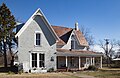
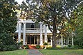
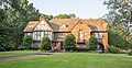
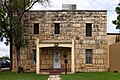
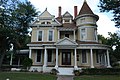
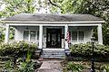
List of Recorded Texas Historic Landmarks (Hunt-Martin)

Last updated

The following is a partial list of Recorded Texas Historic Landmarks (RTHLs) arranged by county as designated by the Texas Historical Commission and local county historical commissions in Texas. This page includes RTHLs in the following counties: Hunt, Hutchinson, Irion, Jack, Jackson, Jasper, Jeff Davis, Jefferson, Jim Hogg, Jim Wells, Johnson, Jones, Karnes, Kaufman, Kendall, Kenedy, Kent, Kerr, Kimble, King, Kinney, Kleberg, Knox, La Salle, Lamar, Lamb, Lampasas, Lavaca, Lee, Leon, Liberty, Limestone, Lipscomb, Live Oak, Llano, Loving, Lubbock, Lynn, Madison, Marion, and Martin.

Contents

Recorded Texas Historic Landmarks listed by county
Anderson-Callahan Cameron-Duval Eastland-Gray Grayson-Hudspeth Hunt-Martin Mason-Rusk Sabine-Travis Trinity-Zavala

KEY

Map all coordinates using: OpenStreetMap

Landmarks with multiple historic designations are colored according to their highest designation within the following hierarchy.

⁕ Listed individually on the National Register of Historic Places (NRHP) as a National Historic Landmark
⁂ Listed on the NRHP as a contributing property of a National Historic Landmark District
Listed individually on the NRHP
Listed as a contributing property of an NRHP Historic District
§ Listed individually as or as part of a State Historic Site
# Listed individually as or as part of a State Antiquities Landmark

Hunt County

Registered Texas Historic LandmarkImageMarker numberPhysical addressNearest cityYear designatedDescription
Bourland-Stevens-Samuell House 7773 1916 Stonewall St.

33°8′37″N96°6′27″W / 33.14361°N 96.10750°W / 33.14361; -96.10750

Greenville 1969
Central Christian Church (Disciples of Christ) Central Christian Church Greenville (1 of 1).jpg
Commons-logo.svg More images
7776 2611 Wesley St.

33°8′19″N96°6′30″W / 33.13861°N 96.10833°W / 33.13861; -96.10833

Greenville 1989
Commerce Post Office Commerce March 2015 7 (Commerce Public Library).jpg
Commons-logo.svg More images
7782 1210 Park St.

33°15′1″N95°53′53″W / 33.25028°N 95.89806°W / 33.25028; -95.89806

Commerce 1991Commerce Public Library
Douglass School Douglas School Greenville Wiki (1 of 1).jpg 17939 1301 Morse St.

33°8′3″N96°5′45″W / 33.13417°N 96.09583°W / 33.13417; -96.09583

Greenville 2014
Gen. Hal C. Horton Home Horton House (1 of 1).jpg 7804 3925 Moulton St.

33°7′44″N96°5′53″W / 33.12889°N 96.09806°W / 33.12889; -96.09806

Greenville 1969
Germany House Germany House (1 of 1).jpg 12090 3403 Lee St.

33°8′23″N96°6′53″W / 33.13972°N 96.11472°W / 33.13972; -96.11472

Greenville 1999
Hunt County Courthouse, 1929 Hunt courthouse 2010.jpg
Commons-logo.svg More images
7823 2507 Lee St.

33°8′22″N96°6′23″W / 33.13944°N 96.10639°W / 33.13944; -96.10639

Greenville 1994
Kavanaugh Methodist Church Kavanaugh United Methodist Church (1 of 1).jpg 7809 2516 Park St.

33°7′53″N96°6′26″W / 33.13139°N 96.10722°W / 33.13139; -96.10722

Greenville 1994
Lone Oak Methodist Church 14123 218 Main St.

32°59′48″N95°56′32″W / 32.99667°N 95.94222°W / 32.99667; -95.94222

Lone Oak 1988
President's House Texas A&M University-Commerce March 2017 02 (Heritage House).jpg
Commons-logo.svg More images
12091 NW corner Stonewall St. at Campbell St.

33°14′33″N95°54′18″W / 33.24250°N 95.90500°W / 33.24250; -95.90500

Commerce 1997Stonewall St., between Bryan and Bois D'Arc, Texas A&M University
W. R. J. Camp House William and Medora Camp House.JPG
Commons-logo.svg More images
7774 2620 Church St.

33°8′34″N96°6′27″W / 33.14278°N 96.10750°W / 33.14278; -96.10750

Greenville 1987

Hutchinson County

Registered Texas Historic LandmarkImageMarker numberPhysical addressNearest cityYear designatedDescription
Ace Borger Home 77 829 N. Hedgecoke St.

35°40′31″N101°23′33″W / 35.67528°N 101.39250°W / 35.67528; -101.39250

Borger 1976829 N. Hedgecoke, Borger
East Ward Elementary School 16744 200 E. 9th St.

35°40′33″N101°23′18″W / 35.67583°N 101.38833°W / 35.67583; -101.38833

Borger 2011Northeast corner of Ninth and Harvey Streets
Girl Scout Little House 15271 119 N. McGee St.

35°39′59″N101°23′41″W / 35.66639°N 101.39472°W / 35.66639; -101.39472

Borger 2008119 N. McGee
Holt School 2515 NW corner FM 281 at CR 22

36°1′24″N101°13′51″W / 36.02333°N 101.23083°W / 36.02333; -101.23083

Stinnett 198916 mi. NE of stinnett on SH 207, then 5.9 mi. E on FM 281
Hutchinson County Courthouse Hutchinson County Texas Courthouse.jpg 2602 500 Main St.

35°49′39″N101°26′32″W / 35.82750°N 101.44222°W / 35.82750; -101.44222

Stinnett 1995S.H. 207, Courthouse Square, Stinnett
Isaac McCormick Cottage, "Birthplace of Hutchinson County" 2 N side 100 blk E. 5th St.

35°49′42″N101°26′32″W / 35.82833°N 101.44222°W / 35.82833; -101.44222

Stinnett 1967North side of Courthouse Square, SH 207 - Stinnett
Plemons Bridge 3-4 VIEW FROM RIVER BED, FROM S. - Stinnett Road Bridge, Spanning Canadian River at County Route 225, Borger, Hutchinson County, TX HAER TX,117-BORG.V,1-4.tif
Commons-logo.svg More images
15709 Plemons Rd. over Canadian River

35°44′51″N101°20′49″W / 35.74750°N 101.34694°W / 35.74750; -101.34694

Borger 2009

Irion County

Registered Texas Historic LandmarkImageMarker numberPhysical addressNearest cityYear designatedDescription
Barnhart Cowboy Church Barnhart Cowboy Church.jpg 258 SE corner 5th St. and Draper St.

31°7′44″N101°10′27″W / 31.12889°N 101.17417°W / 31.12889; -101.17417

Barnhart 1981corner of 5th St. and Draper
Mertzon Central School 3169 302 N. 3rd St.

31°15′36″N100°49′24″W / 31.26000°N 100.82333°W / 31.26000; -100.82333

Mertzon 1962corner of Juanita and Third; marker is inside the school library

Jack County

Registered Texas Historic LandmarkImageMarker numberPhysical addressNearest cityYear designatedDescription
First Methodist Church, Jermyn, Texas Jermyn Methodist Church (1 of 1).jpg 1778 First St. at S. Wise St.

33°15′36″N98°23′31″W / 33.26000°N 98.39194°W / 33.26000; -98.39194

Jermyn 1968Corner of S. Wise and 1st streets
First National Bank First bank building in jack county tx.jpg 1600 101 N. Main St.

33°13′7″N98°9′33″W / 33.21861°N 98.15917°W / 33.21861; -98.15917

Jacksboro 1969US 281 at US 380, west side of courthouse square
Former Gulf, Texas & Western Railroad Depot Gulf Texas and Western Railroad Depot South Elevation.jpg 1947 302 S. Main St.

33°12′55″N98°9′33″W / 33.21528°N 98.15917°W / 33.21528; -98.15917

Jacksboro 1968
Fort Richardson Cavalry Post Hospital, 1867§# 0011Fort Richardson Hospital Jacksboro Texas.jpg
Commons-logo.svg More images
2010 W side of parade ground at Ft. Richardson

33°12′27″N98°9′52″W / 33.20750°N 98.16444°W / 33.20750; -98.16444

Jacksboro 1965Fort Richardson State Historical Park
Fort Richardson Hotel Fort richardson hotel.jpg
Commons-logo.svg More images
2011 101 S. Main St.

33°13′5″N98°9′33″W / 33.21806°N 98.15917°W / 33.21806; -98.15917

Jacksboro 1967US 281 and US 380, southwest corner of courthouse square
Jacksboro's First Railroad Depot Jacksboros First Railroad Depot (9764047394).jpg
Commons-logo.svg More images
2700 S end of Depot St. at Ft. Richardson park boundary

33°12′29″N98°9′40″W / 33.20806°N 98.16111°W / 33.20806; -98.16111

Jacksboro 1974at end of Depot Street, at east gate of Fort Richardson State Historical Park
Officers' Quarters§# Officers Quarters, Jacksboro, Texas (9776588126).jpg
Commons-logo.svg More images
3674 S side of parade ground at Ft. Richardson

33°12′23″N98°9′44″W / 33.20639°N 98.16222°W / 33.20639; -98.16222

Jacksboro 1964Fort Richardson State Historical Park
Old Hess Building Jacksboro2 (1 of 1).jpg 3743 102 N. Church St.

33°13′6″N98°9′26″W / 33.21833°N 98.15722°W / 33.21833; -98.15722

Jacksboro 1967southeast corner of the square

Jackson County

Registered Texas Historic LandmarkImageMarker numberPhysical addressNearest cityYear designatedDescription
Branch and Bonnot House 488 CR 440 E of SH 172

28°53′22″N96°27′54″W / 28.88944°N 96.46500°W / 28.88944; -96.46500

Edna 1965from Edna, take SH 111 East about 9 miles, then go south on FM 172 about 3.75 mile go E on gravel road CR 440 (first house on W side of street)
Dr. Bronaugh-Hasdorff Home 1263 203 E. Brackenridge St.

28°58′36″N96°38′33″W / 28.97667°N 96.64250°W / 28.97667; -96.64250

Edna 1967203 E Breckenridge St., Edna
Dutart-McDowell Home 1307 403 N. Wells St.

28°58′49″N96°38′55″W / 28.98028°N 96.64861°W / 28.98028; -96.64861

Edna 1967Texana Museum, 403 Wells St., Edna
George F. Horton Home 2151 404 Hanover St.

28°58′27″N96°38′42″W / 28.97417°N 96.64500°W / 28.97417; -96.64500

Edna 1966404 Hanover St., Edna
Killough Home 2940 403 N. Wells St.

28°58′49″N96°38′55″W / 28.98028°N 96.64861°W / 28.98028; -96.64861

Edna 1966403 Wells St., Texana Museum, Edna
La Bauve-Young-Payne Home La-Bauve-Young-Payne Home.jpg 2992 112 E. Brackenridge St.

28°58′36″N96°38′36″W / 28.97667°N 96.64333°W / 28.97667; -96.64333

Edna 1967112 E. Brackenridge St., Edna
Meriwether-Simons-Farquhar House 3345 801 S. Allen St.

28°58′10″N96°38′31″W / 28.96944°N 96.64194°W / 28.96944; -96.64194

Edna 1968801 S. Allen ST., Edna
Old J. C. Traylor Place 2670 403 N. Wells St.

28°58′49″N96°38′55″W / 28.98028°N 96.64861°W / 28.98028; -96.64861

Edna 1964Texana Museum, 403 Wells St.
Old Morales Store 3770 10191 SH 111

29°6′28″N96°44′45″W / 29.10778°N 96.74583°W / 29.10778; -96.74583

Morales 1967Hwy. 111, 1 mile S of Morales
Texana Presbyterian Church Texana Presbyterian Church, Edna, TX.jpg 5238 Brackenridge Pkwy., Brackenridge Recreation Complex at Lake Texana

28°56′36″N96°32′20″W / 28.94333°N 96.53889°W / 28.94333; -96.53889

Edna 1981FM 1822/510, S. Apollo Dr., Edna (near SE city limits)
Ward-Coates Home 5717 6 mi. S on SH 172

28°45′5″N96°27′11″W / 28.75139°N 96.45306°W / 28.75139; -96.45306

La Ward 1965From La Ward, take US 172 S. about 6 miles, then go E over cattle guard about .3 miles - house is visible from road.

Jasper County

Registered Texas Historic LandmarkImageMarker numberPhysical addressNearest cityYear designatedDescription
Andrew F. Smyth Home Smyth House1 (1 of 1).jpg 10464 0.9 mi. N of FM 2799 on CR 101

30°56′7″N94°8′39″W / 30.93528°N 94.14417°W / 30.93528; -94.14417

Jasper 19658 mi. W Jasper SH63 to FM 1747 to Bevilport Rd. Turn at first road. .9 mi to "Smyth's Landing"
Beaty-Orton House# BlakeBeatyOrtonHouse1 (1 of 1).jpg 10433 206 S. Main St.

30°55′8″N93°59′58″W / 30.91889°N 93.99944°W / 30.91889; -93.99944

Jasper 1976
Belle-Jim Hotel Belle Jim Hotel Jasper Texas 2018.jpg 11941 160 N. Austin St.

30°55′18″N93°59′57″W / 30.92167°N 93.99917°W / 30.92167; -93.99917

Jasper 1999
Bridges House 10436 1 mi. N of FM 2254 on CR 434

30°48′17″N93°54′51″W / 30.80472°N 93.91417°W / 30.80472; -93.91417

Roganville 1966take FM 2254 W to Rockhill Rd. N about 1 mi.
Hardy Pace Home 10461 1965
R. C. Doom House 10441 7602 FM 2799

30°55′25″N94°7′27″W / 30.92361°N 94.12417°W / 30.92361; -94.12417

Jasper 1965on FM 2799 about 9 mi. W of Jasper near junction of FM 2799 and FM 1747
Waggoner-Scarborough Home 10466 731 N. Main St.

30°55′39″N94°0′4″W / 30.92750°N 94.00111°W / 30.92750; -94.00111

Jasper 1986

Jeff Davis County

Registered Texas Historic LandmarkImageMarker numberPhysical addressNearest cityYear designatedDescription
First Rural School West of Pecos River First Rural School West of Pecos River.jpg
Commons-logo.svg More images
10477 SH 118 11 mi. SE of Fort Davis

30°31′12″N103°46′8″W / 30.52000°N 103.76889°W / 30.52000; -103.76889

Fort Davis 1967take SH 118 SE approx. 11 miles to ROW
Fort Davis United Methodist Church 17051 200 S. Front St.

30°35′16″N103°53′45″W / 30.58778°N 103.89583°W / 30.58778; -103.89583

Fort Davis 1962Front Street & Woodward Ave.
Grierson-Sproul House Grierson-Sproul House.JPG 18381 901 Court Ave.

30°35′26″N103°54′17″W / 30.59056°N 103.90472°W / 30.59056; -103.90472

Fort Davis 2016
Jeff Davis County Courthouse # JeffDavisCountyCourthouse.jpg
Commons-logo.svg More images
12368 100 Court Ave.

30°35′18″N103°53′42″W / 30.58833°N 103.89500°W / 30.58833; -103.89500

Fort Davis 2000at the intersection of SH 17 and SH 118 in Fort Davis
Jeff Davis County Jail JeffDavisCoJailEarly.jpg 16485 100 Woodward Ave.

30°35′17″N103°53′42″W / 30.58806°N 103.89500°W / 30.58806; -103.89500

Fort Davis 2010Fort Davis, 100 West Woodward Avenue
Smith-Carlton Adobe House 17533 940 S. Front St.

30°34′37″N103°53′47″W / 30.57694°N 103.89639°W / 30.57694; -103.89639

Fort Davis 2013
Trueheart, Henry M. and Annie V., House Trueheart House.jpg
Commons-logo.svg More images
10488 804 Court Ave.

30°35′20″N103°54′8″W / 30.58889°N 103.90222°W / 30.58889; -103.90222

Fort Davis 19644 blocks S of Courthouse Square; corner of 7th and Court St.
Union Mercantile Fort Davis, Texas 2.JPG
Commons-logo.svg More images
10489 100 Memorial Sq.

30°35′20″N103°53′37″W / 30.58889°N 103.89361°W / 30.58889; -103.89361

Fort Davis 1965N of the Courthouse Square

Jefferson County

Registered Texas Historic LandmarkImageMarker numberPhysical addressNearest cityYear designatedDescription
Boudreaux House 14513 10714 E. Clubb Rd.

29°56′11″N94°14′56″W / 29.93639°N 94.24889°W / 29.93639; -94.24889

Fannett 1966.5 mi. E of SH 124 on Broussard Cemetery Rd., S of Fannett
Caroline Gilbert Hinchee House Hinchee house beaumont tx 2014.jpg 10534 1814 Park St.

30°4′12″N94°5′38″W / 30.07000°N 94.09389°W / 30.07000; -94.09389

Beaumont 1982
Central Fire Station Fire Museum of Texas in Beaumont.jpg 10498 400 Walnut St.

30°5′10″N94°5′55″W / 30.08611°N 94.09861°W / 30.08611; -94.09861

Beaumont 1983
Clubhouse of the Federated Women's Clubs of Port Arthur Port arthur federated womens clubhouse.jpg 10515 1924 Lakeshore Dr.

29°52′54″N93°55′22″W / 29.88167°N 93.92278°W / 29.88167; -93.92278

Port Arthur 1982
David Crockett Middle School (RAZED) 10505 1400 Royal St.

30°4′9″N94°6′5″W / 30.06917°N 94.10139°W / 30.06917; -94.10139

Beaumont 1984Building razed 1996.
Dugat-Hamshire House 10510 11916 Dugat Rd.

29°54′51″N94°15′17″W / 29.91417°N 94.25472°W / 29.91417; -94.25472

Fannett 1974off SH 124, 12 mi. SW of Beaumont in Fannett
Ellwood-Craig House Pompeiian Villa by Michael Reed fastturtles.org.jpg 10512 1953 Lakeshore Dr.

29°52′59″N93°55′22″W / 29.88306°N 93.92278°W / 29.88306; -93.92278

Port Arthur 1973
First National Bank Building Fnbbuildingbmt.jpg
Commons-logo.svg More images
10521 495 Orleans St.

30°4′59″N94°5′57″W / 30.08306°N 94.09917°W / 30.08306; -94.09917

Beaumont 1989
French Trading Post 2014-10-11 Beaumont, Tx., French Trading, Historic homes 014.JPG
Commons-logo.svg More images
10527 2995 French Rd.

30°6′36″N94°8′35″W / 30.11000°N 94.14306°W / 30.11000; -94.14306

Beaumont 1970
Fuller, Ruby Ruth, Building 15944 300 Stilwell Blvd.Blvd.

29°52′45″N93°55′35″W / 29.87917°N 93.92639°W / 29.87917; -93.92639

Port Arthur 2009
Gates Memorial Library Gates Memorial Library by Michael Reed fastturtles.org 01.jpg
Commons-logo.svg More images
10530 317 Stilwell Blvd.

29°52′42″N93°55′38″W / 29.87833°N 93.92722°W / 29.87833; -93.92722

Port Arthur 1981
Hamshire House 10533 E. Hamshire Rd. E of Gallier Rd.

29°51′33″N94°17′16″W / 29.85917°N 94.28778°W / 29.85917; -94.28778

Hamshire 1966
Hebert Home 14837 Beaumont 1965
Holmes Duke House Holmes Duke.JPG 10511 694 Forrest St.

30°5′15″N94°6′18″W / 30.08750°N 94.10500°W / 30.08750; -94.10500

Beaumont 1986
Jefferson Theatre Jefferson Theatre facade, Beaumont, Texas.jpg
Commons-logo.svg More images
10537 345 Fannin St.

30°4′54″N94°5′52″W / 30.08167°N 94.09778°W / 30.08167; -94.09778

Beaumont 1978
McFaddin-Ward House The McFaddin-Ward House in Beaumont, Texas, now a house museum, was built in 1905-1906 in the striking and distinctive Beaux-Arts Colonial style LCCN2014631187.tif
Commons-logo.svg More images
10542 1906 McFaddin Ave.

30°5′14″N94°6′56″W / 30.08722°N 94.11556°W / 30.08722; -94.11556

Beaumont 1976
Mildred Buildings Mildred buildings comm beaumont tx 2014.jpg
Commons-logo.svg More images
11946 1415, 1425-95 Calder Ave.

30°5′8″N94°6′36″W / 30.08556°N 94.11000°W / 30.08556; -94.11000

Beaumont 1999
Morris-Booz-White House 10545 2545 Lakeshore Dr.Blvd.

29°53′14″N93°55′5″W / 29.88722°N 93.91806°W / 29.88722; -93.91806

Port Arthur 1988
Pivoto-Robinson House 10552 FM 1009 E of Bonner Rd.

30°1′21″N94°25′48″W / 30.02250°N 94.43000°W / 30.02250; -94.43000

Nome 1981off US 1009, .7 mi. south of US 90 in Nome
Saint Anthony's Cathedral Matter Ecclesia.JPG
Commons-logo.svg More images
10560 700 Jefferson St.

30°4′40″N94°6′3″W / 30.07778°N 94.10083°W / 30.07778; -94.10083

Beaumont 1980
Sanders House Sanders house beaumont tx 2014.jpg 10561 479 Pine St.

30°5′10″N94°5′53″W / 30.08611°N 94.09806°W / 30.08611; -94.09806

Beaumont 1982
South County Office Building South county office building port arthur tx.jpg 10565 525 Lakeshore Dr.

29°52′14″N93°55′58″W / 29.87056°N 93.93278°W / 29.87056; -93.93278

Port Arthur 1989
Texas' First Rice Mill Texas' First Rice Mill -- Beaumont, Texas.jpg 10576 1800 Pecos St.

30°4′53″N94°6′48″W / 30.08139°N 94.11333°W / 30.08139; -94.11333

Beaumont 1968
Tyrrell Public Library Tyrrelllibrarycrop.jpg
Commons-logo.svg More images
10578 695 Pearl St.

30°4′56″N94°5′48″W / 30.08222°N 94.09667°W / 30.08222; -94.09667

Beaumont 1976
Vuylstekke House 10579 1831 Lakeshore Dr.

29°52′54″N93°55′28″W / 29.88167°N 93.92444°W / 29.88167; -93.92444

Port Arthur 1996
Woodworth House (Rose Hill) # Rose hill by Michael Reed fastturtles.org.jpg 10582 100 Woodworth Blvd.

29°53′24″N93°54′54″W / 29.89000°N 93.91500°W / 29.89000; -93.91500

Port Arthur 1978
Woodworth House (Rose Hill) # 10583 100 Woodworth Blvd.

29°53′24″N93°54′54″W / 29.89000°N 93.91500°W / 29.89000; -93.91500

Port Arthur 1978

Jim Hogg County

Registered Texas Historic LandmarkImageMarker numberPhysical addressNearest cityYear designatedDescription
Hotel Viggo Abandoned Hotel Viggo in Hebbronville, TX IMG 3387.JPG 2576 205 N. Smith Ave.

27°18′29″N98°40′43″W / 27.30806°N 98.67861°W / 27.30806; -98.67861

Hebbronville 1983205 N. Smith Street (SH 16), Hebbronville
New York Store 16538 308 E. Galbraith St.

27°18′24″N98°40′32″W / 27.30667°N 98.67556°W / 27.30667; -98.67556

Hebbronville 2010on 306 E. Galbraith St. off Texas Hwy 359 and east of Hwy 16; downtown Hebbronville facing south in the middle of the street
Old Garza Home 6054 602 E. Santa Clara St.

27°18′30″N98°40′20″W / 27.30833°N 98.67222°W / 27.30833; -98.67222

Hebbronville 1962602 E. Santa Clara Street, Hebbronville
Randado Catholic Church 4183 County road 0.5 mi. N of SH 16 just E of FM 649

27°4′51″N98°52′44″W / 27.08083°N 98.87889°W / 27.08083; -98.87889

Hebbronville 1962from Hebbronville, take SH 16 about 22 miles south to town of Randada - go north about .5 mile on county road to church, Randado

Jim Wells County

Registered Texas Historic LandmarkImageMarker numberPhysical addressNearest cityYear designatedDescription
McGill Brothers Building McGill Brothers Building Alice Texas 2021.jpg 3294 66 S. Wright St.

27°44′58″N98°4′27″W / 27.74944°N 98.07417°W / 27.74944; -98.07417

Alice 199466 South Wright Street, Alice

Johnson County

Registered Texas Historic LandmarkImageMarker numberPhysical addressNearest cityYear designatedDescription
Carnegie Library Building# Carnegie library cleburne 2010.jpg 731 201 N. Caddo St.

32°20′54″N97°23′11″W / 32.34833°N 97.38639°W / 32.34833; -97.38639

Cleburne 1981201 North Caddo Street, Cleburne
Church of the Holy Comforter Church of the Holy Comforter (1 of 1).jpg 860 209 E. Wardville St.

32°20′56″N97°23′6″W / 32.34889°N 97.38500°W / 32.34889; -97.38500

Cleburne 1970209 East Wardville, Cleburne
Emory Home Emory House Grandview (1 of 1).jpg 1481 300 College St.

32°15′57″N97°10′29″W / 32.26583°N 97.17472°W / 32.26583; -97.17472

Grandview 1986700 East College, Grandview
First Methodist Church Alvarado Methodist Church (1 of 1).jpg 1741 301 S. Spears St.

32°24′18″N97°12′44″W / 32.40500°N 97.21222°W / 32.40500; -97.21222

Alvarado 1965301 South Spear Street, Alvarado
Godley School Godley School Main Building.jpg
Commons-logo.svg More images
16441 309 N. Pearson St.

32°27′13″N97°31′52″W / 32.45361°N 97.53111°W / 32.45361; -97.53111

Godley 2010309 N. Pearson
Henry Briden Cabin Briden Cabin (1 of 1).jpg 2443 301 S. SH 174

32°14′6″N97°22′46″W / 32.23500°N 97.37944°W / 32.23500; -97.37944

Rio Vista 1975First State Bank grounds, Highway 174, Rio Vista
John L. and Annie Upshaw Cleveland House Cleveland House (1 of 1).jpg 12864 808 S. Anglin St.

32°20′28″N97°23′0″W / 32.34111°N 97.38333°W / 32.34111; -97.38333

Cleburne 2002808 S. Anglin St
Johnson County Courthouse # Johnson County Courthouse (1 of 1).jpg
Commons-logo.svg More images
2831 2 Main St.

32°20′50″N97°23′10″W / 32.34722°N 97.38611°W / 32.34722; -97.38611

Cleburne 1999Courthouse Square, Highway 174–171, Cleburne
Johnson County Feeders Supply Johnson County Feeders Supply (1 of 1).jpg 18013 302 S. Caddo St.

32°20′43″N97°23′8″W / 32.34528°N 97.38556°W / 32.34528; -97.38556

Cleburne 2014southwest corner of S. Caddo and Harrell streets
Joiner-Long House# Joiner long house 2010.jpg 12890 604 Prairie Ave.

32°20′23″N97°23′29″W / 32.33972°N 97.39139°W / 32.33972; -97.39139

Cleburne 2002604 Prairie Avenue
Little Old House Little Old House (1 of 1).jpg 3099 409 N. Buffalo St.

32°20′56″N97°23′25″W / 32.34889°N 97.39028°W / 32.34889; -97.39028

Cleburne 1965409 North Buffalo Street, Cleburne
Lowell Smith Home SmithRanch1.jpg 3077 1500 FM 916

32°14′20″N97°21′27″W / 32.23889°N 97.35750°W / 32.23889; -97.35750

Rio Vista 1965from Rio Vista, take FM 916 west 1 mile;

private property

Meredith Hart House 3344 0.5 mi. E on FM 916

32°14′21″N97°21′29″W / 32.23917°N 97.35806°W / 32.23917; -97.35806

Rio Vista 1965Private

from Rio Vista, take FM 916 .5 mile east

Mizpah Gate Mizpah Gate Burleson (1 of 1).jpg 15977 100 W. Hillcrest St.

32°23′47″N97°19′36″W / 32.39639°N 97.32667°W / 32.39639; -97.32667

Keene 2009in front of 100 W. Hillcrest
Renfro-Clark House Renfro-Clark House Burleson (1 of 2).jpg 4244 128 N. Clark St.

32°32′40″N97°19′3″W / 32.54444°N 97.31750°W / 32.54444; -97.31750

Burleson 1970128 North Clark Street, Burleson
Riggs Pennington Home 3983 E side SH 171 on S edge of town

32°19′23″N97°22′36″W / 32.32306°N 97.37667°W / 32.32306; -97.37667

Cleburne 1965Highway 171, Hillsboro Highway, at Cleburne City Limits (east side of street)
Yellow Jacket Stadium Yellow Jacket Stadium (1 of 1).jpg 16542 1201 W. Henderson St.

32°20′30″N97°24′4″W / 32.34167°N 97.40111°W / 32.34167; -97.40111

Cleburne 2010South side of West Henderson Street - approximately 2 miles from the Johnson County Courthouse

Jones County

Registered Texas Historic LandmarkImageMarker numberPhysical addressNearest cityYear designatedDescription
Anson Opera House The 1907 opera house in Anson, Texas, near Abilene. The building was once the largest such music hall between Fort Worth and El Paso LCCN2015630044.tif 173 1120 11th St.

32°45′26″N99°53′50″W / 32.75722°N 99.89722°W / 32.75722; -99.89722

Anson 19631120, 11th St., Anson
Avoca Methodist Church 252 Howard St. at CR 604

32°51′58″N99°42′56″W / 32.86611°N 99.71556°W / 32.86611; -99.71556

Avoca 1981Howard Street
First Baptist Church Stamford First Baptist Church.jpg 15310 214 N. Swenson St.

32°56′50″N99°48′8″W / 32.94722°N 99.80222°W / 32.94722; -99.80222

Stamford 1989
First Presbyterian Church Building 1826 1300 Ave. K

32°45′26″N99°53′50″W / 32.75722°N 99.89722°W / 32.75722; -99.89722

Anson 1990
First United Methodist Church of Anson First United Methodist Church, Anson, TX IMG 6242.JPG 1880 832 Commercial Ave.

32°45′33″N99°53′50″W / 32.75917°N 99.89722°W / 32.75917; -99.89722

Anson 1982
Jones County Courthouse Jones County Courthouse Anson Texas 2009.JPG
Commons-logo.svg More images
12415 1100 12th St.

32°45′23″N99°53′47″W / 32.75639°N 99.89639°W / 32.75639; -99.89639

Anson 200011th St. and Commercial (US 277/83), Anson
St. John's Methodist Church St Johns Methodist Church Stamford Texas.jpg 5046 200 S. Ferguson St.

32°56′38″N99°47′59″W / 32.94389°N 99.79972°W / 32.94389; -99.79972

Stamford 1964Corner of Hamilton and Ferguson streets
Swenson Ranch Commissary 11984 201 S. Swenson St.

32°56′37″N99°48′16″W / 32.94361°N 99.80444°W / 32.94361; -99.80444

Stamford 1999

Karnes County

Registered Texas Historic LandmarkImageMarker numberPhysical addressNearest cityYear designatedDescription
First Presbyterian Church 1815 405 E. Mayfield St.

28°53′17″N97°53′51″W / 28.88806°N 97.89750°W / 28.88806; -97.89750

Karnes City 1970405 E. Mayfield, Karnes City
First Store in Panna Maria Panna-maria-tx(snoga-store)2016-3.jpg
Commons-logo.svg More images
1874 13870 FM 81

28°57′27″N97°53′56″W / 28.95750°N 97.89889°W / 28.95750; -97.89889

Panna Maria 1966FM 81, Panna Maria
Immaculate Conception Church Panna-maria-tx(church)2016-4.jpg
Commons-logo.svg More images
2619 SW corner FM 81 at CR 382

28°57′26″N97°53′53″W / 28.95722°N 97.89806°W / 28.95722; -97.89806

Panna Maria 1966FM 81, Panna Maria
John Gawlik House 17888 NE corner CR 381 at CR 242

28°57′30″N97°54′1″W / 28.95833°N 97.90028°W / 28.95833; -97.90028

Panna Maria 2014Northeast Corner of CR 381 and CR 242 in Panna Maria.
Old Helena Courthouse Old Helena Courthouse Wiki (1 of 1).jpg 3742 FM 81 at W. CR 302

28°57′1″N97°49′14″W / 28.95028°N 97.82056°W / 28.95028; -97.82056

Helena 1962Old Courthouse Square, FM 81, Helena
Ox-Cart Road (Section of Chihuahua Road) 3892 FM 81 at W. CR 302

28°57′3″N97°49′14″W / 28.95083°N 97.82056°W / 28.95083; -97.82056

Helena 1967Old courthouse Square, FM 81, Helena
Pilarczyk Store Panna-maria-tx(pilarczyk-store)2016-2.jpg
Commons-logo.svg More images
4016 13879 FM 81

28°57′28″N97°53′55″W / 28.95778°N 97.89861°W / 28.95778; -97.89861

Panna Maria 1968FM 81, Panna Maria
Saint Joseph's School Panna-maria-tx(schoolhouse)2016-2.jpg
Commons-logo.svg More images
4459 CR 382 SE of FM 81

28°57′26″N97°53′50″W / 28.95722°N 97.89722°W / 28.95722; -97.89722

Panna Maria 1990FM 81, Panna Maria
Saint Joseph's School Panna-maria-tx(schoolhouse)2016-3.jpg
Commons-logo.svg More images
14815 CR 382 SE of FM 81

28°57′26″N97°53′50″W / 28.95722°N 97.89722°W / 28.95722; -97.89722

Panna Maria 1966
Saint Matthew's Episcopal Church 4472 309 S. Fifth St.

28°48′56″N97°51′4″W / 28.81556°N 97.85111°W / 28.81556; -97.85111

Kenedy 1986309 S. 5th Street, Kenedy

Kaufman County

Registered Texas Historic LandmarkImageMarker numberPhysical addressNearest cityYear designatedDescription
Carnegie Library Building# Carnegie Library Terrell Wiki.jpg
Commons-logo.svg More images
9425 207 N. Frances St.

32°44′17″N96°16′42″W / 32.73806°N 96.27833°W / 32.73806; -96.27833

Terrell 1983
Cartwright House CartwrightHouse1.JPG
Commons-logo.svg More images
9424 505 Griffith Ave.

32°44′44″N96°17′4″W / 32.74556°N 96.28444°W / 32.74556; -96.28444

Terrell 1968
Church of Our Merciful Saviour Church of Our Merciful Saviour Wiki (1 of 1).jpg 8500 500 S. Jackson St.

32°35′11″N96°18′37″W / 32.58639°N 96.31028°W / 32.58639; -96.31028

Kaufman 1967500 block of S. Jackson St., Kaufman
Church of the Good Shepherd Church of the Good Shepherd Terrell Wiki.jpg 8499 200 W. College St.

32°44′23″N96°16′41″W / 32.73972°N 96.27806°W / 32.73972; -96.27806

Terrell 1967200 W. College (corner of College and Frances Sts.), Terrell
Covenant United Presbyterian Church Covenant United Presbyterian Church Kaufman Wiki (1 of 1).jpg 8504 400 E. Mulberry St.

32°35′20″N96°18′23″W / 32.58889°N 96.30639°W / 32.58889; -96.30639

Kaufman 1971400 E. Mulberry St., Kaufman
Dick P. Moore House Dick Moore House(1 of 1).jpg 8536 306 S. Bois d'Arc St.

32°44′51″N96°28′23″W / 32.74750°N 96.47306°W / 32.74750; -96.47306

Forney 1985306 S. Bois d'Arc St., Forney
Dr. L. E. Griffith Home Dr. L. E. Griffith Home Terrell Wiki.jpg 8524 805 First St.

32°44′36″N96°16′58″W / 32.74333°N 96.28278°W / 32.74333; -96.28278

Terrell 1962805 First St., Terrell
Duncan and Emma McKellar House McKellerHouse Forney (1 of 1).jpg 16928 306 S. Center St.

32°44′43″N96°28′18″W / 32.74528°N 96.47167°W / 32.74528; -96.47167

Forney 2011Forney, 306 S. Center St.
Forney High School Building Forney high school building forney tx.jpg
Commons-logo.svg More images
8518 600 S. Bois d'Arc St.

32°44′39″N96°28′36″W / 32.74417°N 96.47667°W / 32.74417; -96.47667

Forney 1994600 S. Bois d'Arc St., Forney
Greenslade Drug Store Greenslade drug store.jpg 8523 111 W. Mulberry St.

32°35′20″N96°18′35″W / 32.58889°N 96.30972°W / 32.58889; -96.30972

Kaufman 1968111 W. Mulberry St. on public square, Kaufman
Griffith House Griffith House Terrell Wiki.jpg 18851 801 First St.

32°44′33″N96°17′1″W / 32.74250°N 96.28361°W / 32.74250; -96.28361

Terrell 2017At the corner of First and Johnson Streets, North, 30 Degrees West of the center of the intersection of those streets in Terrell.
Huff-Park House Huff-Park House Kaufman Wiki (1 of 1).jpg 8527 201 Wykagyl St.

32°35′25″N96°18′49″W / 32.59028°N 96.31361°W / 32.59028; -96.31361

Kaufman 1971201 N. Wykagyl, Kaufman
John H. Corley Home John H. Corley Home Terrell Wiki.jpg 8501 720 Griffith Ave.

32°44′57″N96°17′15″W / 32.74917°N 96.28750°W / 32.74917; -96.28750

Terrell 1968720 Griffith Ave., Terrell
McKellar House 8534 303 S. Center St.

32°44′40″N96°28′17″W / 32.74444°N 96.47139°W / 32.74444; -96.47139

Forney 1989303 S. Center St., Forney
R. L. Warren House WarrenCrowellHouse1.JPG 8560 705 Griffith Ave.

32°44′51″N96°17′12″W / 32.74750°N 96.28667°W / 32.74750; -96.28667

Terrell 1973705 Griffith Avenue, Terrell
Robert A. Terrell Home Robert A. Terrell Home Terrell Wiki.jpg 8554 Bowser Cir., Southwestern Christian College

32°44′6″N96°17′5″W / 32.73500°N 96.28472°W / 32.73500; -96.28472

Terrell 1962on campus of Southwestern Christian College on Bowser St., enter off US 80/Moore Ave., Terrell
Terrell Elementary School Terrell Elmentary School Wiki.jpg 8555 700 N. Catherine St.

32°44′39″N96°16′32″W / 32.74417°N 96.27556°W / 32.74417; -96.27556

Terrell 1997700 N. Catherine St., Terrell
Texas & Pacific Railroad Freight Depot Terrell Train Depot 2 Wiki.jpg 8559 200 S. Virginia St.

32°44′7″N96°16′32″W / 32.73528°N 96.27556°W / 32.73528; -96.27556

Terrell 1996200 S. Virginia St., Terrell
Victorian Residence, 1883 (Cartwright House) Victorian home, built by banker and rancher Matthew Cartwright in 1883 in Terrell, Texas, in Kaufman County, east of Dallas LCCN2014633643.jpg
Commons-logo.svg More images
15332 505 Griffith Ave.

32°44′44″N96°17′4″W / 32.74556°N 96.28444°W / 32.74556; -96.28444

Terrell 1968
W. E. Henderson Home 8525 26239 FM 429

32°47′26″N96°11′24″W / 32.79056°N 96.19000°W / 32.79056; -96.19000

Terrell 1970from the intersection of US 80 and FM 429 on the eastern edge of Terrell, take FM 429 NE about 5 1/2 miles to home on W side of road
Walter P. and Meck Allen House Walter P. and Meck Allen House Terrell Wiki.jpg 13855 611 Griffith Ave.

32°44′50″N96°17′11″W / 32.74722°N 96.28639°W / 32.74722; -96.28639

Terrell 2004
William and Blanche Brooks House BrooksHouse1.JPG 11986 500 S. Center St.

32°44′34″N96°28′24″W / 32.74278°N 96.47333°W / 32.74278; -96.47333

Forney 1997

Kendall County

Registered Texas Historic LandmarkImageMarker numberPhysical addressNearest cityYear designatedDescription
1860 Temporary Headquarters of Gen. Robert E. Lee Boerne-tx(robert-e-lee-house)2016-1.jpg
Commons-logo.svg More images
23 N side E. Evergreen St. E of S. Main St.

29°47′18″N98°43′43″W / 29.78833°N 98.72861°W / 29.78833; -98.72861

Boerne 1963Main and Evergreen Street, Boerne
1907 Comfort State Bank Building Comfort-tx(bank)2016-2.jpg
Commons-logo.svg More images
29 NW corner High St. and Seventh St.

29°58′2″N98°54′29″W / 29.96722°N 98.90806°W / 29.96722; -98.90806

Comfort 1988Corner 7th and High Streets, Comfort
Arno Schwethelm Building Comfort-tx2016-26(arno-schwethelm-bldg).jpg
Commons-logo.svg More images
208 701 High St.

29°58′0″N98°54′29″W / 29.96667°N 98.90806°W / 29.96667; -98.90806

Comfort 19817th and High Streets, Comfort
August Ebers House 236 W of Old Hwy. 9 S of Gillespie County line

30°8′10″N98°49′6″W / 30.13611°N 98.81833°W / 30.13611; -98.81833

Fredericksburg 1983from Comfort take Old State Road 9 fourteen miles to house in Bankersmith
August Faltin Building Comfort-tx(august-faltin-building)2016-3.jpg
Commons-logo.svg More images
237 NW corner Main St. and Seventh St.

29°57′57″N98°54′32″W / 29.96583°N 98.90889°W / 29.96583; -98.90889

Comfort 1982Main and Seventh, Comfort
Beseler House 383 518 N. Main St.

29°47′53″N98°44′3″W / 29.79806°N 98.73417°W / 29.79806; -98.73417

Boerne 1985
Comfort Community Church 998 318 High St.

29°58′13″N98°54′48″W / 29.97028°N 98.91333°W / 29.97028; -98.91333

Comfort 1986High Street, between 2nd and 3rd, Comfort
Comfort Post Office Comfort TX Old Post Office.jpg
Commons-logo.svg More images
1000 715 High St.

29°58′0″N98°54′27″W / 29.96667°N 98.90750°W / 29.96667; -98.90750

Comfort 1986
Comfort School 17739 232 High St.

29°58′15″N98°54′53″W / 29.97083°N 98.91472°W / 29.97083; -98.91472

Comfort 2013NW corner of 3rd and High Streets
Fabra Smokehouse Boerne-tx(fabra-smokehouse)2016-3.jpg
Commons-logo.svg More images
1546 202 S. Main St.

29°47′33″N98°43′55″W / 29.79250°N 98.73194°W / 29.79250; -98.73194

Boerne 1980smokehouse on S side of 194 Main Street building - Boerne
Faltin Homestead Comfort-tx2016-37(faltin-home).jpg
Commons-logo.svg More images
1564 430 Seventh St.

29°57′58″N98°54′32″W / 29.96611°N 98.90889°W / 29.96611; -98.90889

Comfort 1962Main and Seventh Street, Comfort
Hanisch House 2361 Fourth St. N of Cypress Creek Comfort 1965SH 27 and Cypress Creek, Comfort
Henry J. Graham Building Boerne-tx2015-22(henry-j-graham-building).jpg
Commons-logo.svg More images
2449 402 E. Blanco Rd.

29°47′47″N98°43′49″W / 29.79639°N 98.73028°W / 29.79639; -98.73028

Boerne 1986on W side of city hall
Hygieostatic Bat Roost Hygieostatic bat roost comfort 2009.jpg
Commons-logo.svg More images
2608 400 ft. S of FM 473 1.5 mi. E of town

29°58′13″N98°53′5″W / 29.97028°N 98.88472°W / 29.97028; -98.88472

Comfort 1981from Comfort take FM 473 about 1.5 miles E - bat roost is about 400 feet S of the highway
Idlewilde Lodge 2615 115 FM 473

29°58′3″N98°52′59″W / 29.96750°N 98.88306°W / 29.96750; -98.88306

Comfort 1983from Comfort, take FM 473 about 1.5 miles E - turn S onto road to lodge, about .5 mile to site
Ingenhuett-Faust Hotel Comfort TX Faust Hotel.jpg
Commons-logo.svg More images
2646 717 High St.

29°58′0″N98°54′26″W / 29.96667°N 98.90722°W / 29.96667; -98.90722

Comfort 1985
Ingenhuett-Karger Saloon Comfort-tx2016-42(karger-saloon).jpg
Commons-logo.svg More images
15937 725 High St.

29°57′59″N98°54′25″W / 29.96639°N 98.90694°W / 29.96639; -98.90694

Comfort 2009
James House 2726 114 Oak Park Dr.

29°47′2″N98°43′42″W / 29.78389°N 98.72833°W / 29.78389; -98.72833

Boerne 1982
Joseph Dienger Building Joseph dienger building.jpg
Commons-logo.svg More images
2857 106 West Blanco

29°47′40″N98°43′55″W / 29.79444°N 98.73194°W / 29.79444; -98.73194

Boerne 1981
Julius A. and Anna Phillip House 2888 116 N. Plant Ave.

29°47′54″N98°43′32″W / 29.79833°N 98.72556°W / 29.79833; -98.72556

Boerne 1993
Karger Building Comfort TX Karger Building Marker.jpg
Commons-logo.svg More images
15936 723 High St.

29°57′59″N98°54′26″W / 29.96639°N 98.90722°W / 29.96639; -98.90722

Comfort 2009725 High Street
Kendalia Community Church Kendalia community church 2013.jpg 2919 108 Arthur St.

29°58′9″N98°31′36″W / 29.96917°N 98.52667°W / 29.96917; -98.52667

Kendalia 1979Jones and Arthurs Streets, Kendalia - two blocks N of SH 473
Kendall County Courthouse # Historic kendall courthouse 2013.jpg
Commons-logo.svg More images
2921 204 E. San Antonio Ave.

29°47′40″N98°43′50″W / 29.79444°N 98.73056°W / 29.79444; -98.73056

Boerne 1970San Antonio and Watts Streets, east of Main Street, Boerne
Kuhlmann-King House Kuhlmann king house 2013.jpg
Commons-logo.svg More images
2977 402 E. Blanco Rd.

29°47′44″N98°43′48″W / 29.79556°N 98.73000°W / 29.79556; -98.73000

Boerne 1982on W side of city hall
Lex Sanitarium 14702 300 yds. S of Johns Rd. 1 mi. W of town Boerne 1991
Ludwig Hein Home Comfort-tx2017-4(ludwig-hein-home).jpg
Commons-logo.svg More images
3145 622 High St.

29°58′3″N98°54′30″W / 29.96750°N 98.90833°W / 29.96750; -98.90833

Comfort 1987
Otto Brinkmann House Otto brinkman house 2009.jpg
Commons-logo.svg More images
3882 602 High St.

29°58′4″N98°54′32″W / 29.96778°N 98.90889°W / 29.96778; -98.90889

Comfort 1976
Paul Ingenhuett Home Comfort-tx(paul-ingenhuett-home)2016-2.jpg
Commons-logo.svg More images
3956 417 Eighth St.

29°57′57″N98°54′25″W / 29.96583°N 98.90694°W / 29.96583; -98.90694

Comfort 1979
Rice Home 15626 Near Cypress Creek Comfort 1965
Saint Peter's Catholic Church 4484 800 S. Main St.

29°47′11″N98°43′47″W / 29.78639°N 98.72972°W / 29.78639; -98.72972

Boerne 1987800 Block South Main Street, Boerne
Stieler Ranch House 5120 6 mi. N on US 87

30°3′56″N98°55′0″W / 30.06556°N 98.91667°W / 30.06556; -98.91667

Comfort 1970at site, U.S. 87, 6 mile N of Comfort, Texas
Stotts Home (Robert E. Lee House) Boerne-tx(robert-e-lee-house)2016-3.jpg
Commons-logo.svg More images
14280 N side E. Evergreen St. E of S. Main St.

29°47′18″N98°43′43″W / 29.78833°N 98.72861°W / 29.78833; -98.72861

Boerne 1963
The Gass Schmiede Comfort-tx(the-gass-schmiede)2015-2.jpg
Commons-logo.svg More images
5343 SW corner High St. and Eighth St.

29°57′59″N98°54′24″W / 29.96639°N 98.90667°W / 29.96639; -98.90667

Comfort 19868th and High Streets, Comfort
Theis House 5460 Newton Alley behind 242 S. Main St.

29°47′31″N98°43′52″W / 29.79194°N 98.73111°W / 29.79194; -98.73111

Boerne 1984on Newton Alley behind 242 Main Street, Boerne
Vogt-Clegg Log House 5660 221 S. Plant Ave.

29°47′40″N98°43′29″W / 29.79444°N 98.72472°W / 29.79444; -98.72472

Boerne 1993**On Private Property**
Waring Schoolhouse Waring-schoolhouse2016-2.jpg
Commons-logo.svg More images
5719 108 Ave. E

29°57′10″N98°48′17″W / 29.95278°N 98.80472°W / 29.95278; -98.80472

Waring 1986108 Avenue, Waring - from Comfort take IH-10 2 miles S, then FM 1621 5 miles E to Waring
Welfare School Welfare School Wiki (1 of 1).jpg 12370 217 Waring-Welfare Rd.

29°57′7″N98°48′19″W / 29.95194°N 98.80528°W / 29.95194; -98.80528

Welfare 2000
Weyrich Building 16468 714 S. Main St.

29°47′12″N98°43′45″W / 29.78667°N 98.72917°W / 29.78667; -98.72917

Boerne 2010714 South Main Street
Ye Kendall Inn Kendall inn 2009.jpg
Commons-logo.svg More images
5925 128 W. Blanco

29°47′38″N98°44′0″W / 29.79389°N 98.73333°W / 29.79389; -98.73333

Boerne 1962

Kenedy County

Registered Texas Historic LandmarkImageMarker numberPhysical addressNearest cityYear designatedDescription
The Armstrong Ranch House 5287 E of US 77 S 20 mi.

26°56′11″N97°45′53″W / 26.93639°N 97.76472°W / 26.93639; -97.76472

Sarita 1982from Sarita, take US 77 south about 20 miles - private - no access

Kent County

Registered Texas Historic LandmarkImageMarker numberPhysical addressNearest cityYear designatedDescription
First National Bank Building First National Bank Building Jayton Texas.jpg
Commons-logo.svg More images
11993 102 Donaho St.

33°14′52″N100°34′28″W / 33.24778°N 100.57444°W / 33.24778; -100.57444

Jayton 1997
Old Kent County Jail Clairemont jail.jpg 3756 Jct. SH 208 at CR 200

33°10′4″N100°45′11″W / 33.16778°N 100.75306°W / 33.16778; -100.75306

Clairemont 1965junction of US 380 and SH 208, Clairemont

Kerr County

Registered Texas Historic LandmarkImageMarker numberPhysical addressNearest cityYear designatedDescription
A. C. Schreiner, Jr. Home 51 405 Water St.

30°2′57″N99°8′41″W / 30.04917°N 99.14472°W / 30.04917; -99.14472

Kerrville 1981405 Water Street, Kerrville
Cade House 11992 375 Cade Loop Rd.

30°4′7″N99°16′11″W / 30.06861°N 99.26972°W / 30.06861; -99.26972

Ingram 1999Cade Loop Road, 1.3 mi. S of SH 39
Camp Verde Barracks 680 Camp Verde Rd. 0.5 mi. W of SH 173

29°53′27″N99°7′19″W / 29.89083°N 99.12194°W / 29.89083; -99.12194

Camp Verde 1962From Kerrville, take SH 173 to Camp Verde. Turn W onto Farm Road N of Verde Creek near junction with 480. Continue .5 mile to site. On private property.
Camp Verde General Store and Post Office Camp-verde-tx(general-store&post-office)2016-2.jpg
Commons-logo.svg More images
681 285 E. Verde Creek Rd.

29°53′39″N99°6′17″W / 29.89417°N 99.10472°W / 29.89417; -99.10472

Camp Verde 1971From Kerrville, take SH 173 S approximately 13 miles to Camp Verde. Store is located near intersection with FM 480.
Captain Charles Schreiner Kerrville-tx2017-26(schreiner-mansion).jpg
Commons-logo.svg More images
710 216 Earl Garrett St.

30°2′46″N99°8′23″W / 30.04611°N 99.13972°W / 30.04611; -99.13972

Kerrville 1970216 Earl Garrett Street, Kerrville
Captain Charles Schreiner Home Capt charles schreiner mansion 2015.jpg
Commons-logo.svg More images
711 216 Earl Garrett St.

30°2′46″N99°8′23″W / 30.04611°N 99.13972°W / 30.04611; -99.13972

Kerrville 1962216 Earl Garrett Street, Kerrville
First Presbyterian Church of Kerrville First Presbyterian Church, Kerrville, TX IMG 0381.JPG 1840 800 Jefferson St.

30°2′51″N99°8′17″W / 30.04750°N 99.13806°W / 30.04750; -99.13806

Kerrville 1995800 Jefferson
First Presbyterian Church of Kerrville (sanctuary) 14483 800 Jefferson St.

30°2′51″N99°8′17″W / 30.04750°N 99.13806°W / 30.04750; -99.13806

Kerrville 1987
First School House 1863 1736 Y.O. Ranch Rd.

30°12′26″N99°40′7″W / 30.20722°N 99.66861°W / 30.20722; -99.66861

Mountain Home 1967from Mountain Home take SH 41 approximately 15.2 miles to Y.O. Ranch - marker located at visitor's complex
Guthrie Building Guthrie Building Kerrville TX.JPG
Commons-logo.svg More images
14000 241 Earl Garrett St.

30°2′47″N99°8′22″W / 30.04639°N 99.13944°W / 30.04639; -99.13944

Kerrville 2007241 Earl Garrett Street
Kennedy-Petersen House 18623 840 Earl Garrett St.

30°3′7″N99°8′2″W / 30.05194°N 99.13389°W / 30.05194; -99.13389

Kerrville 2017
Masonic Building Masonic building kerrville 2009.jpg
Commons-logo.svg More images
14261 211 Earl Garrett St.

30°2′44″N99°8′23″W / 30.04556°N 99.13972°W / 30.04556; -99.13972

Kerrville 2008211 Earl Garrett St.
Remount Station 4240 1736 Y.O. Ranch Rd.

30°12′26″N99°40′7″W / 30.20722°N 99.66861°W / 30.20722; -99.66861

Mountain Home 1967from Mountain Home, take SH 41 approximately 15.2 miles to the Y.O. Ranch - marker located at visitor's complex
San Antonio & Aransas Pass Passenger Train Depot 18622 615 Schreiner St.

30°2′59″N99°8′20″W / 30.04972°N 99.13889°W / 30.04972; -99.13889

Kerrville 2017
Scott and Josephine Carr Schreiner 17951 425 Water St.

30°2′55″N99°8′39″W / 30.04861°N 99.14417°W / 30.04861; -99.14417

Kerrville 2014
The Comparette Home 5312 1001 Jefferson St.

30°2′40″N99°8′6″W / 30.04444°N 99.13500°W / 30.04444; -99.13500

Kerrville 19791001 Jefferson Street, Kerrville
The Cypress Creek School Cypress-creek-school2016-2(kerr-county).jpg
Commons-logo.svg More images
5318 Stoneleigh Rd. 0.5 mi. from FM 1341

30°1′1″N98°58′39″W / 30.01694°N 98.97750°W / 30.01694; -98.97750

Kerrville 1982from Kerrville, take FM 1341 about 10 miles to Cypress Creek - turn S onto Stonleigh Road, about .5 miles to school
Woolls Building Woolls building 2009.jpg 12604 318 San Antonio St.

29°56′40″N99°2′13″W / 29.94444°N 99.03694°W / 29.94444; -99.03694

Center Point 2001

Kimble County

Registered Texas Historic LandmarkImageMarker numberPhysical addressNearest cityYear designatedDescription
Brambletye BRAMBLETYE, JUNCTION, KIMBLE COUNTY, TX.jpg 265 RM 2291 2.7 mi. N of I-10

30°33′51″N99°51′21″W / 30.56417°N 99.85583°W / 30.56417; -99.85583

Junction 1983from Junction, take IH-10W about 4 miles, then north 2.7 miles on FM 2291
Campsite of Marques De Rubi, 1767 1188 RM 1674 0.9 mi. E of RM 2291

30°31′16″N99°49′23″W / 30.52111°N 99.82306°W / 30.52111; -99.82306

Junction 1967about 4 miles NW of Junction on HWY 1674
First Church in Community Copperas Methodist Church 1528 I-10 N. frontage road E. of jct. RM 1674 at Exit 442

30°30′0″N99°58′48″W / 30.50000°N 99.98000°W / 30.50000; -99.98000

Junction 1968from Junction go west on IH-10 11.5 miles - take exit FM 1674, go east 1.1 miles to marker and church
Hogget Home 2321 0.5 mi. along previous US 377 roadway from jct. US 377 and Park Road 73

30°26′42″N99°49′22″W / 30.44500°N 99.82278°W / 30.44500; -99.82278

Junction 1965from Junction, take US 377 about 5 miles to turnoff to state park (Hwy. 73) - take right on dead end road, go .5 mi. to home (private property)
Kimble County Courthouse Kimble county courthouse 2009.jpg
Commons-logo.svg More images
11708 501 Main St.

30°29′20″N99°45′57″W / 30.48889°N 99.76583°W / 30.48889; -99.76583

Junction 2000
Kimble County Jail Kimble County Jail Junction Texas 2023.jpg 2892 415 Pecan St.

30°29′24″N99°45′54″W / 30.49000°N 99.76500°W / 30.49000; -99.76500

Junction 1964N. 5th and Pecan St.
Marvin E. and Retta Ann Blackburn House 13206 1720 College St.

30°29′19″N99°46′46″W / 30.48861°N 99.77944°W / 30.48861; -99.77944

Junction 20041720 College Street
Masonic Hall Masonic Hall Junction Texas 2023.jpg 3164 613 Main St.

30°29′21″N99°46′1″W / 30.48917°N 99.76694°W / 30.48917; -99.76694

Junction 1966
Near Route of Old Military Road 3545 I-10 S. frontage road at FM 2169 jct. at Exit 465

30°25′4″N99°40′19″W / 30.41778°N 99.67194°W / 30.41778; -99.67194

Junction 1975from Junction, take IH-10E about 8 miles to Exit #465 (Segovia) - marker is on access road in front of truck stop
Old Cloud Home 3638 FM 2169 5 mi. E. of Junction

30°30′5″N99°42′1″W / 30.50139°N 99.70028°W / 30.50139; -99.70028

Junction 1964on FM 2169 5 miles east of Junction
Old Log Cabin 3641 101 N. Fourth St.

30°29′19″N99°45′52″W / 30.48861°N 99.76444°W / 30.48861; -99.76444

Junction 1965corner of 4th and College St. (museum)
Old Noxville School 3618 CR 4731 near Knoxville Cemetery

30°22′18″N99°23′29″W / 30.37167°N 99.39139°W / 30.37167; -99.39139

Junction 196829 miles E of Junction Via FM 479 on CR just E of little Devil's River; school is about 1/2 down CR.
Old Rock Store, 1879 Old Rock Store Junction Texas 2023.jpg 4323 119 N. Sixth St.

30°29′19″N99°46′0″W / 30.48861°N 99.76667°W / 30.48861; -99.76667

Junction 1964Corner of 6th and College St., Junction
Reichenau Gap 4238 1.5 miles SW of London on US 377

30°39′11″N99°35′16″W / 30.65306°N 99.58778°W / 30.65306; -99.58778

London 19661.5 miles SW of London on US 377

King County

Registered Texas Historic LandmarkImageMarker numberPhysical addressNearest cityYear designatedDescription
King County Courthouse King County Courthouse (1 of 1).jpg 2945 700 Baker St.

33°37′8″N100°19′20″W / 33.61889°N 100.32222°W / 33.61889; -100.32222

Guthrie 1962Courthouse, intersection of Highway 82 and 83, Guthrie

Kinney County

Registered Texas Historic LandmarkImageMarker numberPhysical addressNearest cityYear designatedDescription
1873 Infantry Barracks 16385 367 Fort Clark Rd.

29°18′16″N100°25′15″W / 29.30444°N 100.42083°W / 29.30444; -100.42083

Brackettville 2010Brackettville, 367 Fort Clark Road
1886 Kitchen/Mess Hall 18182 2-3 Mackenzie Rd

29°18′24″N100°25′10″W / 29.30667°N 100.41944°W / 29.30667; -100.41944

Brackettville 2015
8 Medallions on Officers' Row Quarters 17 Colony Row

29°18′21″N100°25′20″W / 29.30583°N 100.42222°W / 29.30583; -100.42222

Brackettville 1991
Adjutant's Quarters (Quarters # 20) 12001 20 Colony Row

29°18′15″N100°25′25″W / 29.30417°N 100.42361°W / 29.30417; -100.42361

Brackettville 1999
Army Service Club 15793 154 Fort Clark Rd.

29°18′49″N100°25′3″W / 29.31361°N 100.41750°W / 29.31361; -100.41750

Brackettville 2009154 Fort Clark Road
Catholic Church 761 301 S. Sweeney St.

29°18′25″N100°25′8″W / 29.30694°N 100.41889°W / 29.30694; -100.41889

Brackettville 1966fronts Sweeney Street, just past (south of) where it crosses El Paso Street, Brackettville
Catholic Church 14206 301 S. Sweeney St.

29°18′49″N100°25′3″W / 29.31361°N 100.41750°W / 29.31361; -100.41750

Brackettville 1962
Commanding Officer's Quarters 1001 29 Colony Row

29°18′21″N100°25′21″W / 29.30583°N 100.42250°W / 29.30583; -100.42250

Brackettville 1988No. 29 colony row, Ft. Clark Springs, Brackettville
Filippone Building 12735 W. El Paso St. and James St.

29°18′51″N100°25′5″W / 29.31417°N 100.41806°W / 29.31417; -100.41806

Brackettville 2001El Paso and Brown Streets
Fort Clark Guardhouse 1976 McClernand Rd. at Crockett Rd.

29°18′16″N100°25′7″W / 29.30444°N 100.41861°W / 29.30444; -100.41861

Brackettville 1962on northeast corner of McClernand and Baylor Street, Fort Clark Springs, Brackettville
Fort Clark Post Theater 12002 Patton Dr. at Fort Clark Rd.

29°18′18″N100°25′16″W / 29.30500°N 100.42111°W / 29.30500; -100.42111

Brackettville 1997SW corner of Fort Clark Rd. and Patton Rd., Fort Clark Springs
Kinney County Courthouse# Kinney courthouse.jpg 13189 501 N. Ann St.

29°18′48″N100°25′3″W / 29.31333°N 100.41750°W / 29.31333; -100.41750

Brackettville 2003Brackettville, 501 N. Ann Street
Las Moras Masonic Lodge Building 3040 503 S. Ann St.

29°18′41″N100°25′2″W / 29.31139°N 100.41722°W / 29.31139; -100.41722

Brackettville 1990Ann Street (Highway 334) at Cook Alley, Brackettville
Married Officers' Quarters 8-9 13643 8 Colony Row

29°18′21″N100°25′20″W / 29.30583°N 100.42222°W / 29.30583; -100.42222

Brackettville 20068 Colony Row
Montalvo House 3440 103 E. Thomas St.

29°18′50″N100°24′53″W / 29.31389°N 100.41472°W / 29.31389; -100.41472

Brackettville 1979building now fronts Thomas Street just east of where H crosses Ann Street (and Rt. 334), Brackettville (called "The Well")
New Cavalry Barracks 15811 123 McClernand Road

29°18′17″N100°25′5″W / 29.30472°N 100.41806°W / 29.30472; -100.41806

Brackettville 2009123 McClernand Road
Officers' Club Open Mess 16424 1 McClernand Rd.N

29°18′23″N100°25′12″W / 29.30639°N 100.42000°W / 29.30639; -100.42000

Brackettville 2010
Officers Quarters 2-3 and 4 13963 2-3-4 Colony Row

29°18′27″N100°25′18″W / 29.30750°N 100.42167°W / 29.30750; -100.42167

Brackettville 2007Fort Clark Springs
Officers' Row Quarters 3678 Colony Row

29°18′18″N100°25′25″W / 29.30500°N 100.42361°W / 29.30500; -100.42361

Fort Clark Springs 1991Colony ROW Road between Nos. 8, 9 and 10, Ft. Clark Springs, Brackettville
Old Guard House 3738 Patton Dr.

29°18′21″N100°25′18″W / 29.30583°N 100.42167°W / 29.30583; -100.42167

Brackettville 1962fronts Patton Road in fort's interior open space, Fort Clark, Brackettville
Partrick Building 15039 114 North St.

29°18′41″N100°25′6″W / 29.31139°N 100.41833°W / 29.31139; -100.41833

Brackettville 2008114 North Street
Robert E. Lee Building 4295 Baylor St. at NW corner with Lee Ct.

29°18′18″N100°25′12″W / 29.30500°N 100.42000°W / 29.30500; -100.42000

Brackettville 1963northwest corner of Lee and Baylor Streets, Fort Clark, Brackettville
Ross Home 4353 500 S. Ann St.

29°18′40″N100°25′2″W / 29.31111°N 100.41722°W / 29.31111; -100.41722

Brackettville 1962located on Ann Street (Highway 334) directly across from Chamber of Commerce and Masonic Lodge, Brackettville
Staff Officers' Quarters 5086 Bend of Colony Row

29°18′17″N100°25′27″W / 29.30472°N 100.42417°W / 29.30472; -100.42417

Brackettville 1990Colony ROW between quarters Nos. 22 and 25, Ft. Clark Springs, Brackettville
U.S. Army Signal Corps Building 15094 202 McClain Road

29°18′17″N100°25′28″W / 29.30472°N 100.42444°W / 29.30472; -100.42444

Brackettville 2008

Kleberg County

Registered Texas Historic LandmarkImageMarker numberPhysical addressNearest cityYear designatedDescription
Henrietta M. King High School Henrietta M. King High School, Kingsville, Texas.JPG 2440 400 W. King Ave.

27°31′0″N97°52′22″W / 27.51667°N 97.87278°W / 27.51667; -97.87278

Kingsville 1981Kleberg and Third Avenue, Kingsville
Historic Cattle Dipping Vat 763 3 mi. N on Bus. US 77

27°33′13″N97°50′12″W / 27.55361°N 97.83667°W / 27.55361; -97.83667

Kingsville 1967from Kingsville, take US 77 (business route) 3 miles north
Kingsville Railroad Depot Kingsville Railroad Depot Wiki.jpg 2955 102 E. Kleberg Ave.

27°31′1″N97°52′6″W / 27.51694°N 97.86833°W / 27.51694; -97.86833

Kingsville 1974Kleberg Avenue and railroad track (7th Street), Kingsville
Robert J. Kleberg Public Library Robert J. Kleberg Library Kingsville Wiki.jpg 4297 SE corner W. Yoakum Ave. at N. Third St.

27°31′3″N97°52′18″W / 27.51750°N 97.87167°W / 27.51750; -97.87167

Kingsville 1981Third and Yoakum streets (southeast corner), Kingsville
Santa Gertrudis, Headquarters of the King Ranch King Ranch Main House 2.jpg
Commons-logo.svg More images
4583 Ranch road W of jct. SH 141 at W. Santa Gertrudis St.

27°31′4″N97°55′2″W / 27.51778°N 97.91722°W / 27.51778; -97.91722

Kingsville 1981on private property—King Ranch off SH 141 at west edge of Kingsville

Knox County

Registered Texas Historic LandmarkImageMarker numberPhysical addressNearest cityYear designatedDescription
Benjamin School (razed) 9430 E. Hayes St. and S. Church St.

33°35′32″N99°47′23″W / 33.59222°N 99.78972°W / 33.59222; -99.78972

Benjamin 1966Hwy. 82 and S. Church St.
Brazos River Bridge State Highway16 Bridge at the Brazos River.jpg 18703 SH 6 over Brazos River

33°30′2″N99°48′7″W / 33.50056°N 99.80194°W / 33.50056; -99.80194

Benjamin 20156 miles south of Benjamin on Hwy 6
First Christian Church (razed) 1699 N. Bedford St. and E. Dimmit St.

33°35′7″N99°47′29″W / 33.58528°N 99.79139°W / 33.58528; -99.79139

Benjamin 1967corner of E. Bedford St. and E. Dimmit St., Benjamin

La Salle County

Registered Texas Historic LandmarkImageMarker numberPhysical addressNearest cityYear designatedDescription
Welhausen School 8138 204 NE. Lane St.

28°25′49″N99°13′42″W / 28.43028°N 99.22833°W / 28.43028; -99.22833

Cotulla 1990204 NE Lane St.

Lamar County

Registered Texas Historic LandmarkImageMarker numberPhysical addressNearest cityYear designatedDescription
Atkinson-Morris House Atkinson-Morris House, Paris, TX.jpg 8182 802 Fitzhugh Ave.

33°40′7″N95°32′49″W / 33.66861°N 95.54694°W / 33.66861; -95.54694

Paris 1972
Capt. Wm. E. Moore Home 8211 1965
Central Presbyterian Church Paris July 2015 27 (Central Presbyterian Church).jpg 8189 309 S. Church St.

33°39′31″N95°33′15″W / 33.65861°N 95.55417°W / 33.65861; -95.55417

Paris 1994
Ewing House 8192 135 Fourth St. NW

33°39′46″N95°33′38″W / 33.66278°N 95.56056°W / 33.66278; -95.56056

Paris 1967
First Presbyterian Church First Presbyterian Church Paris.jpg 8197 410 W. Kaufman St.

33°39′36″N95°33′37″W / 33.66000°N 95.56028°W / 33.66000; -95.56028

Paris 1968
Hayes House 8200 901 S. Main St.

33°39′12″N95°33′22″W / 33.65333°N 95.55611°W / 33.65333; -95.55611

Paris 1983
Home of Sam Bell Maxey §# Sam Bell Maxey House in Paris Texas DSC 0616 ad.JPG
Commons-logo.svg More images
8208 812 S. Church St.

33°39′14″N95°33′17″W / 33.65389°N 95.55472°W / 33.65389; -95.55472

Paris 1962
J. M. Biard House Lamar County Historical Museum February 2016 22 (1846 Biard Loghouse).jpg
Commons-logo.svg More images
8183 1015 W. Kaufman St.

33°39′33″N95°33′58″W / 33.65917°N 95.56611°W / 33.65917; -95.56611

Paris 1965
J. M. Early House 8191 1970 Clarksville St.

33°39′19″N95°32′7″W / 33.65528°N 95.53528°W / 33.65528; -95.53528

Paris 1968
Judge Wm. Henry Lightfoot House 8207 746 S. Church St.

33°39′16″N95°33′17″W / 33.65444°N 95.55472°W / 33.65444; -95.55472

Paris 1965
Lamar County Courthouse# Paris July 2015 41 (Lamar County Courthouse).jpg
Commons-logo.svg More images
12313 119 N. Main St.

33°39′45″N95°33′24″W / 33.66250°N 95.55667°W / 33.66250; -95.55667

Paris 2000
Lightfoot-Coleman House 12012 746 S. Church St.

33°39′16″N95°33′17″W / 33.65444°N 95.55472°W / 33.65444; -95.55472

Paris 1965
McCuistion Home Johnson-McCuistion House, Paris, TX.jpg 8210 730 Clarksville St.

33°39′36″N95°32′56″W / 33.66000°N 95.54889°W / 33.66000; -95.54889

Paris 1965
Pleasant Grove 8231 1.5 mi. E on FM 1184

33°31′10″N95°37′8″W / 33.51944°N 95.61889°W / 33.51944; -95.61889

Howland 1966FM 1184 abvout 1.5 mi. east of Howland
Scott Mansion Scott mansion tx 2010.jpg 8225 425 S. Church St.

33°39′27″N95°33′15″W / 33.65750°N 95.55417°W / 33.65750; -95.55417

Paris 1984
Union Station Paris, TX Union Station.jpg
Commons-logo.svg More images
13688 1100 W. Kaufman St.

33°39′35″N95°34′1″W / 33.65972°N 95.56694°W / 33.65972; -95.56694

Paris 2002Paris, 1100 W. Kaufman
Wilburn Family Home 8230 Petty 1973private property - call CHC for information
William Huddle Home 8202 1038 FM 2820

33°42′7″N95°38′42″W / 33.70194°N 95.64500°W / 33.70194; -95.64500

Hopewell 1968on FM 2820 in Hopewell, across from VFW
Williams, Sheb, Home 14599 1.5 mi. E on FM 1184

33°31′10″N95°37′8″W / 33.51944°N 95.61889°W / 33.51944; -95.61889

Howland 1966

Lamb County

Registered Texas Historic LandmarkImageMarker numberPhysical addressNearest cityYear designatedDescription
Old Watering Trough 3832 S side E 100 blk US 84

34°4′2″N102°31′27″W / 34.06722°N 102.52417°W / 34.06722; -102.52417

Sudan 1966on US 84 between Commerce & Main Streets-Sudan; marker faces dirt access road
Spade Ranch Headquarters, North 14752 Hart Camp 1965
Sudan Hotel 5145 104 E. First Ave.

34°3′59″N102°31′30″W / 34.06639°N 102.52500°W / 34.06639; -102.52500

Sudan 1963on 1st Street, between Main & Commerce-Sudan

Lampasas County

Registered Texas Historic LandmarkImageMarker numberPhysical addressNearest cityYear designatedDescription
A. J. Northington House 54 803 S. Live Oak St.

31°3′44″N98°10′35″W / 31.06222°N 98.17639°W / 31.06222; -98.17639
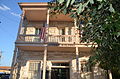
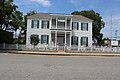
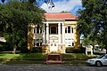
Lampasas 1964
C.C. Abney House Abney House Lampasas (1 of 1).jpg 594 402 S. Broad St.

31°3′50″N98°11′5″W / 31.06389°N 98.18472°W / 31.06389; -98.18472
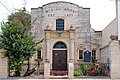
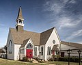
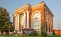
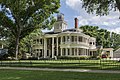
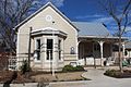
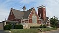
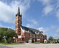
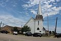
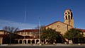
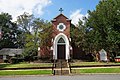
Lampasas 1964402 South Broad Street, Lampasas
Central Christian Church of Lampasas Old central christian church lampasas.jpg 793 201 E. Third St.

31°3′55″N98°10′52″W / 31.06528°N 98.18111°W / 31.06528; -98.18111

Lampasas 1985NE corner of Chestnut and Third Street, Lampasas
First Public School in Lampasas 1858 NE corner of N. Main St. at E. North Ave.

31°4′6″N98°10′52″W / 31.06833°N 98.18111°W / 31.06833; -98.18111
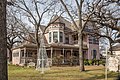
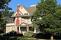
Lampasas 1965NE corner of intersection of N. Main St. & E. North Ave. BUILDING RAZED
Hart House Hart House Lampasas Texas 2022.jpg 2398 511 Western Ave.

31°3′51″N98°10′42″W / 31.06417°N 98.17833°W / 31.06417; -98.17833

Lampasas 1966511 Western Avenue, Lampasas
Huling Cottage Lampasas Huling Cottage (1 of 1).jpg 2595 205 E. Second St.

31°3′59″N98°10′52″W / 31.06639°N 98.18111°W / 31.06639; -98.18111

Lampasas 1965205 Second Street, Lampasas
J. A. Adkins House 2666 1211 Taylor St.

31°3′58″N98°10′4″W / 31.06611°N 98.16778°W / 31.06611; -98.16778
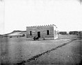
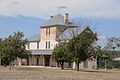
Lampasas 19661211 Taylor Street, Lampasas
John Patterson House Patterson House Adamsville (1 of 1).jpg 2797 E of US 281 on S edge of town

31°18′0″N98°10′7″W / 31.30000°N 98.16861°W / 31.30000; -98.16861
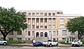
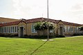
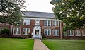
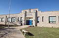
Adamsville 1964east side of Highway 281, s. city limits, Adamsville
Junior High School Lampasas Junior High School (1 of 1).jpg 14325 N. Main St. at E. Ave. A

31°4′9″N98°10′55″W / 31.06917°N 98.18194°W / 31.06917; -98.18194
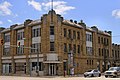
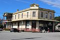
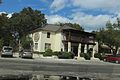
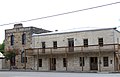
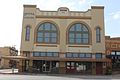
Lampasas 1965
Keystone Hotel Keystone hotel lampasas tx 2015.jpg 2935 404 E. Second St.

31°3′59″N98°10′45″W / 31.06639°N 98.17917°W / 31.06639; -98.17917
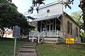
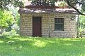
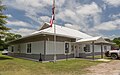
Lampasas 1965404 Second Street, Lampasas
Lampasas Colored School LampasasColoredschool1.JPG 15734 514 College St.

31°3′53″N98°10′23″W / 31.06472°N 98.17306°W / 31.06472; -98.17306

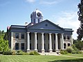
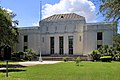
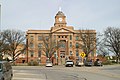
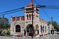
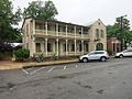
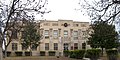
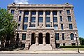
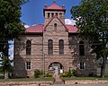
Lampasas 2009
Lampasas County Courthouse# Lampasas County Courthouse.JPG
Commons-logo.svg More images
12795 501 E. Fourth St.

31°3′56″N98°10′40″W / 31.06556°N 98.17778°W / 31.06556; -98.17778

Lampasas 1965Courthouse square, Live Oak St.
Lampasas County Courthouse Site# Lampasas county courthouse.jpg
Commons-logo.svg More images
3023 501 E. Fourth St.

31°3′56″N98°10′40″W / 31.06556°N 98.17778°W / 31.06556; -98.17778

Lampasas 1965Courthouse Square, Western and 3rd, Lampasas
Lampasas County Jail 6023 410 E. Fourth St.

31°3′52″N98°10′42″W / 31.06444°N 98.17833°W / 31.06444; -98.17833

Lampasas 1965In front of new jail, corner (southwest) of Live Oak Street and 4th Street, Lampasas
Lee Straley House 3064 3 mi. N of town E of US 281

31°18′52″N98°10′9″W / 31.31444°N 98.16917°W / 31.31444; -98.16917
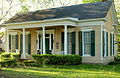
Adamsville 1963from Adamsville, take Highway 281 north about 3 miles, house is on east side of road
Malone-Manuel House Malone Manuel House Lampasas (1 of 1).jpg 14609 502 W. Third St.

31°3′47″N98°11′13″W / 31.06306°N 98.18694°W / 31.06306; -98.18694
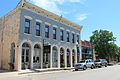
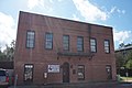
Lampasas 2005
Manuel Hardware Building Manuel Hardware Building Lampasas Texas 2022.jpg 15765 401 E. Third St.

31°3′57″N98°10′45″W / 31.06583°N 98.17917°W / 31.06583; -98.17917

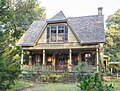
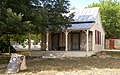
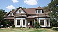
Lampasas 2009
Matt and Rebecca Smith House 13606 202 E. Fifth St.

31°3′47″N98°10′49″W / 31.06306°N 98.18028°W / 31.06306; -98.18028
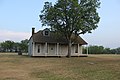
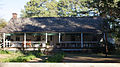
Lampasas 2006202 E 5th St
Moses Hughes Home, 1856 3477 5 mi. W on FM 580

31°5′26″N98°17′39″W / 31.09056°N 98.29417°W / 31.09056; -98.29417
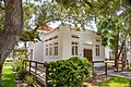
Lampasas 1969from Lampasas, take FM 580 west about 5 miles
Old Cook Home, 1861 1051 313 Water St.

31°3′32″N98°10′32″W / 31.05889°N 98.17556°W / 31.05889; -98.17556
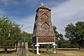
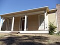
Lampasas 1966Behind Winn Dixie. Driveway located on east side of S. Western Street about 1/10 mile north of Highway 190, Lampasas.
Old Huling Mansion 3751 2.5 mi. W on FM 580, S side of road

31°4′2″N98°15′7″W / 31.06722°N 98.25194°W / 31.06722; -98.25194

Lampasas 1966from Lampasas, take FM 580 west about 2.5 miles (south side of road), private ranch (MARKER REPORTED MISSING 6/23/2009)
Philip Smith House 4007 4684 FM 2527

31°13′26″N98°6′44″W / 31.22389°N 98.11222°W / 31.22389; -98.11222
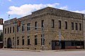
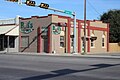
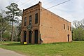
Lampasas 1966From Lampasas, take Highway 281 north about 8 miles, then go east about 4 miles on FM 1690; follow FM 2527 south about 1.3 miles to house (located just south of graveyard on east side of road).
Phillips and Trosper Buildings PhillipsTrosper1.JPG 4010 408-410 E. Third St.

31°3′56″N98°10′42″W / 31.06556°N 98.17833°W / 31.06556; -98.17833

Lampasas 1994408-410 East 3rd Street, Lampasas
Saint Mary's Episcopal Church St marys episcopal lampasas.jpg 4467 501 S. Chestnut St.

31°3′51″N98°10′51″W / 31.06417°N 98.18083°W / 31.06417; -98.18083
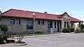
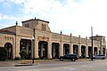
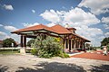
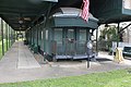
Lampasas 1967Corner of 4th and Chestnut Street, Lampasas
Santa Fe Depot, 1904 Old lampasas tx train depot.jpg 4575 501 E. Second St.

31°4′2″N98°10′43″W / 31.06722°N 98.17861°W / 31.06722; -98.17861

Lampasas 1966Second and Live Oak Street (501 Second St.)
Shade Denson House 4651 S of CR 3010 just past Sulphur Creek crossing

31°3′40″N98°7′45″W / 31.06111°N 98.12917°W / 31.06111; -98.12917
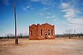
Lampasas 1964From Lampasas take 190 east about 1 mile, then go north on CR 7 about 1.3 mile. House is on south side of road just past Sparks Crossing. (MARKER REPORTED MISSING 6/23/2009)
Site of Old Opera House 4855 302 E. Third St.

31°3′55″N98°10′48″W / 31.06528°N 98.18000°W / 31.06528; -98.18000

Lampasas 1967City Hall, Third Street, Lampasas
Summerville Home 5148 106 N. Broad St.

31°4′2″N98°11′10″W / 31.06722°N 98.18611°W / 31.06722; -98.18611

Lampasas 1964
Trosper Building PhillipsTrosper1.JPG 15490 408-410 E. Third St.

31°3′56″N98°10′42″W / 31.06556°N 98.17833°W / 31.06556; -98.17833

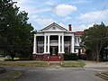
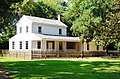
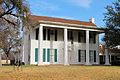
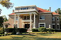
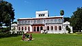
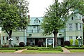
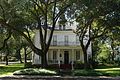
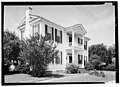
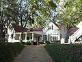
Lampasas 1994
W. N. Huling Home, 1877 5676 204 S. Main St.

31°4′0″N98°10′52″W / 31.06667°N 98.18111°W / 31.06667; -98.18111

Lampasas 1965204 South Main Street, Lampasas
W. R. Hughes Home 5678 Pvt. Rd. 89 E of FM 1715

31°5′45″N98°2′34″W / 31.09583°N 98.04278°W / 31.09583; -98.04278

Kempner 1966Private property. From Kempner, take US 190 West about 3.5 miles, then go north on CR 8 about 2 miles to private drive (no access - house is down private drive #89 about 2 miles near junction of Sulphur Creek and Lampasas).
Witcher House 17108 407 S. Park St.

31°3′47″N98°11′11″W / 31.06306°N 98.18639°W / 31.06306; -98.18639

Lampasas 2012407 S. Park Street

Lavaca County

Registered Texas Historic LandmarkImageMarker numberPhysical addressNearest cityYear designatedDescription
Estate of John Hallett 1489 600 N. La Grange St.

29°27′2″N96°56′36″W / 29.45056°N 96.94333°W / 29.45056; -96.94333

Hallettsville 1967corner of West La Grange and Crockett, Hallettsville
Herder Half Moon Place 2458 1.6 mi. SW on FM 533 from US 90A

29°25′45″N97°12′39″W / 29.42917°N 97.21083°W / 29.42917; -97.21083

Shiner 1982from Shiner, take US 90A west 1.2 mile take FM 531 southwest 1.6 miles
Masonic Lodge Building 3245 511 N. Ave. D

29°25′48″N97°10′12″W / 29.43000°N 97.17000°W / 29.43000; -97.17000

Shiner 1967511 North Avenue D, Shiner
Old Hanging Tree Hallettsville-tx2016-71(hanging-tree).jpg
Commons-logo.svg More images
3740 Park Road 3 in city park next to Hallettsville Golf Course

29°27′13″N96°56′38″W / 29.45361°N 96.94389°W / 29.45361; -96.94389

Hallettsville 1967in city park, in front of Golf Club, west side of US 77 north city limits, Hallettsville
Old Moulton Baptist Church Old-moulton-tx2016-4(baptist-church).jpg
Commons-logo.svg More images
3772 2287 FM 1680

29°35′13″N97°10′33″W / 29.58694°N 97.17583°W / 29.58694; -97.17583

Old Moulton 1970from Moulton, take FM 1680 northwest about 2 miles to Old Moulton
Orrin L. Winters Cabin Moulton-tx2016-22(winters-cabin).jpg
Commons-logo.svg More images
3878 Veterans Dr. in city park

29°34′10″N97°9′1″W / 29.56944°N 97.15028°W / 29.56944; -97.15028

Moulton 1974in City Park, Lancaster Street, Moulton
Orth-Fitch House 3879 507 Coke St.

29°17′8″N97°8′24″W / 29.28556°N 97.14000°W / 29.28556; -97.14000

Yoakum 1983507 Coke Street, Yoakum
Park Place School Building 3937 505 Elenora St.

29°17′36″N97°8′18″W / 29.29333°N 97.13833°W / 29.29333; -97.13833

Yoakum 1996505 Elenora, Yoakum (burned in April 2014)
Saints Cyril and Methodius Catholic Church Saints Cyril and Methodius Church.JPG 4489 306 S. Ave. F

29°25′23″N97°9′56″W / 29.42306°N 97.16556°W / 29.42306; -97.16556

Shiner 1990424 St. Ludmilla, Shiner
Sam and Will Moore Institute Moulton-tx2016-11(sam&will-moore-institute).jpg
Commons-logo.svg More images
4510 400 Bobkat Dr.

29°34′44″N97°8′54″W / 29.57889°N 97.14833°W / 29.57889; -97.14833

Moulton 1973Moulton High School, west Bobcat Drive, Moulton
Shiner Opera House Shiner-tx2016-7(opera-house).jpg
Commons-logo.svg More images
4685 207 E. Seventh St.

29°25′52″N97°10′17″W / 29.43111°N 97.17139°W / 29.43111; -97.17139

Shiner 19797th Street and Avenue D, Shiner
The Lay-Bozka House Hallettsville-tx2016-87(the-lay-bozka-house).jpg
Commons-logo.svg More images
5369 205 Fairwinds St.

29°26′31″N96°56′50″W / 29.44194°N 96.94722°W / 29.44194; -96.94722

Hallettsville 1968205 Fair Winds or 90A, south side of intersection with Hackberry Street, Hallettsville
William Green House 5828 817 N. Ave. E

29°25′53″N97°10′24″W / 29.43139°N 97.17333°W / 29.43139; -97.17333

Shiner 1970Highway 90A, Shiner (across from City Hall)

Lee County

Registered Texas Historic LandmarkImageMarker numberPhysical addressNearest cityYear designatedDescription
Early Chapel Cemetery 8144 0.2 mi. S of FM 696 E 3.2 mi. from Loop 123

30°24′7″N97°3′47″W / 30.40194°N 97.06306°W / 30.40194; -97.06306

Lexington 19673.5 mi. east of Lexington on FM 696, then south on dirt road about .2 mile
Edward R. Sinks House Edward R Sinks House Giddings Texas 2021.jpg 18813 818 E. Hempstead St.

30°10′49″N96°55′49″W / 30.18028°N 96.93028°W / 30.18028; -96.93028

Giddings 2017
First Presbyterian Church Giddings-tx2016-14(first-presbyterian).jpg
Commons-logo.svg More images
8150 132 S. Grimes St.

30°10′55″N96°56′10″W / 30.18194°N 96.93611°W / 30.18194; -96.93611

Giddings 1967Grimes and Hempstead St.
Fletcher Home Giddings-tx2016-12(fletcher-home).jpg
Commons-logo.svg More images
8151 171 E. Hempstead St.

30°10′55″N96°56′12″W / 30.18194°N 96.93667°W / 30.18194; -96.93667

Giddings 1966171 Hempstead at Grimes St.
Lee County Courthouse # Giddings-tx2016-6(lee-county-courthouse).jpg
Commons-logo.svg More images
8166 200 S. Main St.

30°10′53″N96°56′14″W / 30.18139°N 96.93722°W / 30.18139; -96.93722

Giddings 1968Main St.
Old Evergreen Tree Old Evergreen Tree Lee County Texas 2021.jpg 8145 FM 1624 halfway between SH 21 and US 77

30°16′13″N96°57′15″W / 30.27028°N 96.95417°W / 30.27028; -96.95417

Lincoln 1967.5 mi. south on FM 1624 from SH 21/FM 1624 intersection; halfway between SH 21 and US 77
St. Paul's Lutheran Church Serbin church facing the rear.jpg
Commons-logo.svg More images
8175 1572 CR 211

30°6′51″N96°59′17″W / 30.11417°N 96.98806°W / 30.11417; -96.98806

Serbin 19636 miles south of Giddings on FM 448, 4.5 miles west on FM 2239, then south on CR 211, Serbin

Leon County

Registered Texas Historic LandmarkImageMarker numberPhysical addressNearest cityYear designatedDescription
Concord Missionary Baptist Church 9619 CR 348 at SH 7

31°15′20″N96°8′22″W / 31.25556°N 96.13944°W / 31.25556; -96.13944

Concord 1970off SH 7 on CR 348 near cemetery in Concord about 8 mi. S of Jewett; church burned in wildfires in 2011, marker replaced with subject marker in 2012
Evans Chapel Church 17959 4133 FM 977 W

31°7′53″N96°1′39″W / 31.13139°N 96.02750°W / 31.13139; -96.02750

Leona 20144.1 miles west of Leona on FM 977, south (left) side of FM 977
James and Julia Anderson House James and Julia Anderson House Jewett Wiki.jpg 12399 417 Weakley St.

31°21′41″N96°8′53″W / 31.36139°N 96.14806°W / 31.36139; -96.14806

Jewett 1999
Leon County Courthouse# Leon-County-Courthouse.JPG 9629 206 St. Marys St.

31°15′30″N95°58′41″W / 31.25833°N 95.97806°W / 31.25833; -95.97806

Centerville 1966at intersection of SH 7 and SH 75
Old Bowling School and Masonic Lodge 9618 W side FM 1147 near S end

31°12′59″N96°10′48″W / 31.21639°N 96.18000°W / 31.21639; -96.18000

Marquez 1964from Marquez, take SH 7 about 3.8 mi. E to FM 1147, go S about 3 mi. to school on W side of road - just before pavement ends

Liberty County

Registered Texas Historic LandmarkImageMarker numberPhysical addressNearest cityYear designatedDescription
Cleveland-Partlow House Cleveland partlow house liberty tx 2014.jpg 9649 2131 Grand Ave.

30°3′49″N94°47′6″W / 30.06361°N 94.78500°W / 30.06361; -94.78500

Liberty 1962
Dayton's Old School 17880 111 W. Houston Ave.

30°2′36″N94°53′18″W / 30.04333°N 94.88833°W / 30.04333; -94.88833

Dayton 2014Dayton Old School Museum
Gillard - Duncan House 9655 650 FM 1011

30°5′52″N94°45′45″W / 30.09778°N 94.76250°W / 30.09778; -94.76250

Liberty 1981Sam Houston Regional Library and Research Center
Henry O. Ager Home 16900 537 Fannin St.

30°3′39″N94°47′42″W / 30.06083°N 94.79500°W / 30.06083; -94.79500

Liberty 2011Northeast corner of Block 20; corner of Cos & Fannin, one block East of Main St.
Hill and Sara McClanahan House 16840 401 Austin St.

30°20′59″N95°5′18″W / 30.34972°N 95.08833°W / 30.34972; -95.08833

Cleveland 2011
Homestead of John S. and Jane Susanna Lee Brown, 1856 9638 0.5 mi. off SH 61 approx. 4 mi. S Devers 19654 mi. S of Devers, Anahuac Highway 1/2 mi. of road
Judge Walter S. Neel House 17824 1204 N. Main St.

30°3′9″N94°53′36″W / 30.05250°N 94.89333°W / 30.05250; -94.89333

Dayton 20141204 N. Main Street
Old Wells' Store 9692 SH 321 at CR 2274

30°17′34″N94°58′41″W / 30.29278°N 94.97806°W / 30.29278; -94.97806

Cleveland 1968from Cleveland take SH 321 about 7 mi. SE
Ott Hotel 13537 305 Travis St.

30°3′29″N94°47′51″W / 30.05806°N 94.79750°W / 30.05806; -94.79750

Liberty 2005305 Travis
Thomas Jefferson Chambers Home 9644 624 Milam St.

30°3′42″N94°47′53″W / 30.06167°N 94.79806°W / 30.06167; -94.79806

Liberty 1978
Tom Hill House 16405 211 S. Bonham Ave.

30°20′23″N95°5′13″W / 30.33972°N 95.08694°W / 30.33972; -95.08694

Cleveland 2010Cleveland, 211 S. Bonham

Limestone County

Registered Texas Historic LandmarkImageMarker numberPhysical addressNearest cityYear designatedDescription
Bassett House 18240 1343 CR 666

31°19′56″N96°40′2″W / 31.33222°N 96.66722°W / 31.33222; -96.66722

Kosse 20151343 Limestone County Road 666 (located 3 miles northwest of Kosse)
Early Mexia Home 1347 621 N. Red River St.

31°41′16″N96°28′38″W / 31.68778°N 96.47722°W / 31.68778; -96.47722

Mexia 1969621 N Red River - Corner of Red River and Grason St., Mexia
Focke Gin, Old (BURNED) 14338 Mexia 1962
Henry-Martin-Dorsett House 15024 Mexia 1962
Kosse Tabernacle Kosse Tabernacle Wiki (1 of 1).jpg 16984 200 W. Adams St.

31°18′32″N96°37′52″W / 31.30889°N 96.63111°W / 31.30889; -96.63111

Kosse 2011NW Madison &S.W Corner of Adams and Mignonette
L. P. Smith House 2982 101 S. Kaufman St.

31°40′49″N96°28′45″W / 31.68028°N 96.47917°W / 31.68028; -96.47917

Mexia 1967101 S. Kaufmann St. Mexia
Limestone County Courthouse Limestone courthouse tx 2010.jpg 12031 200 W. State St.

31°31′21″N96°32′6″W / 31.52250°N 96.53500°W / 31.52250; -96.53500

Groesbeck 1998
Martin House 3228 SH 14, S of Mexia Mexia 1962From Mexia, take SH 14 south about 3 miles.
Miss Rogers' Music Room 3402 609 N. Bonham St.

31°41′8″N96°28′53″W / 31.68556°N 96.48139°W / 31.68556; -96.48139

Mexia 1965609 N Bonham St., Mexia

Lipscomb County

Registered Texas Historic LandmarkImageMarker numberPhysical addressNearest cityYear designatedDescription
Lipscomb County Courthouse # Lipscomb County, Texas, courthouse from W 1.JPG
Commons-logo.svg More images
12483 Courthouse Sq.

36°14′2″N100°16′14″W / 36.23389°N 100.27056°W / 36.23389; -100.27056

Lipscomb 2000

Live Oak County

Registered Texas Historic LandmarkImageMarker numberPhysical addressNearest cityYear designatedDescription
Charter Oak Gussetville-tx2015(charter-oak)(live-oak-county).jpg 824 FM 799, 6 mi. SE of George West in Gussettville George West 1966from George West, take FM 799 east about 6 miles
Chauncy and Minnie Canfield House 17975 508 Crockett St.

28°20′4″N98°7′3″W / 28.33444°N 98.11750°W / 28.33444; -98.11750

George West 2014Northeast corner of Frio and Crockett Streets
Cunningham Home 17657 411 E. Thornton St.

28°27′36″N98°10′42″W / 28.46000°N 98.17833°W / 28.46000; -98.17833

Three Rivers 2013Northwest corner of East Thornton St. and North Hermann Avenue
First State Bank Building Three-rivers-tx2017-22(bank).jpg 1871 101 E. Thornton St.

28°27′39″N98°10′56″W / 28.46083°N 98.18222°W / 28.46083; -98.18222

Three Rivers 1964Thornton and Harborth Streets, near town square, Three Rivers
Live Oak County Jail Live oak county jail 2009.jpg
Commons-logo.svg More images
18104 107 Currey St.

28°26′56″N98°6′5″W / 28.44889°N 98.10139°W / 28.44889; -98.10139

Oakville 2015Southeast corner of Curry and Community Circle
Murphy Ranch House 18272 2015by Lake Corpus Christi
Rialto Theater Rialto Theater Three Rivers Texas 2020.jpg 18459 106 W. Thornton St.

28°27′39″N98°10′56″W / 28.46083°N 98.18222°W / 28.46083; -98.18222

Three Rivers 2016

Llano County

Registered Texas Historic LandmarkImageMarker numberPhysical addressNearest cityYear designatedDescription
Acme Dry Goods Building Acme Dry Goods Building Llano Texas.jpg 9431 109 W. Main St.

30°45′2″N98°40′35″W / 30.75056°N 98.67639°W / 30.75056; -98.67639

Llano 1987
Antlers Hotel Antlers Porch.jpg 15150 1001 King Ct.

30°39′38″N98°26′12″W / 30.66056°N 98.43667°W / 30.66056; -98.43667

Kingsland 2002
Badu House Badu building 2010.jpg 9433 601 Bessemer Ave.

30°45′24″N98°40′34″W / 30.75667°N 98.67611°W / 30.75667; -98.67611

Llano 1981
Cassaday Grey Granite Company Office Building Cassaday Grey Granite Company Office Building.jpg 9434 501 Bessemer Ave.

30°45′21″N98°40′33″W / 30.75583°N 98.67583°W / 30.75583; -98.67583

Llano 1992
Edna J. Moore Seaholm House 12038 1105 Wright St.

30°44′48″N98°40′43″W / 30.74667°N 98.67861°W / 30.74667; -98.67861

Llano 1998
Ford Street Commercial Row Ford Street Commercial Row Llano Texas.jpg 9439 702, 704, and 706 Ford St.

30°45′4″N98°40′33″W / 30.75111°N 98.67583°W / 30.75111; -98.67583

Llano 1991702, 704, 706 Ford St.
Grace Episcopal Church Grace Episcopal Church Llano Texas.jpg 9441 1200 Oatman St.

30°44′47″N98°40′28″W / 30.74639°N 98.67444°W / 30.74639; -98.67444

Llano 1965
Lappe House 9445 On private property 3 mi. NE of RM 1431 near Ft. Mason crossing on Colorado River

30°42′41″N98°24′44″W / 30.71139°N 98.41222°W / 30.71139; -98.41222

Mason 1964private property
Llano County Courthouse # Llano courthouse 2010.jpg 9446 107 W. Sandstone St.

30°44′59″N98°40′36″W / 30.74972°N 98.67667°W / 30.74972; -98.67667

Llano 1980
Llano County Jail Former llano county jail 2010.jpg 9448 700 Oatman St.

30°45′3″N98°40′28″W / 30.75083°N 98.67444°W / 30.75083; -98.67444

Llano 1979
Old Southern Hotel Building Southern hotel in in Llano, Texas 2010.jpg 9455 201 W. Main St.

30°45′1″N98°40′38″W / 30.75028°N 98.67722°W / 30.75028; -98.67722

Llano 1981corner of Berry and Main
Robert F. Rowntree House 18463 18606 RM 2323

30°34′3″N98°52′24″W / 30.56750°N 98.87333°W / 30.56750; -98.87333

Llano 201620 miles SW of town of Llano, less than 1 mile east of Prairie Mountain School on RR 2323
Trinity Methodist Church 18029 Old Schoolhouse Rd.

30°42′1″N98°47′29″W / 30.70028°N 98.79139°W / 30.70028; -98.79139

Castell 1962Old Schoolhouse Road, off FM 152
Watkins House 9459 210 W. Sandstone St.

30°44′56″N98°40′41″W / 30.74889°N 98.67806°W / 30.74889; -98.67806

Llano 1994

Loving County

Registered Texas Historic LandmarkImageMarker numberPhysical addressNearest cityYear designatedDescription
Mentone Community Church 3340 NW corner Pecos St. and Wheat St.

31°42′29″N103°36′4″W / 31.70806°N 103.60111°W / 31.70806; -103.60111

Mentone 1964on Church, 3 blocks N. of Courthouse Mentone

Lubbock County

Registered Texas Historic LandmarkImageMarker numberPhysical addressNearest cityYear designatedDescription
Arnett House 18255 2100 Dover Ave.

33°34′30″N101°55′59″W / 33.57500°N 101.93306°W / 33.57500; -101.93306

Lubbock 2015
Bacon Home Warren and Myrta Bacon House (west).JPG
Commons-logo.svg More images
273 1802 Broadway St.

33°35′6″N101°51′23″W / 33.58500°N 101.85639°W / 33.58500; -101.85639

Lubbock 19821802 Broadway, Lubbock.
Bledsoe Santa Fe Depot 434 6105 19th St.

33°34′39″N101°56′58″W / 33.57750°N 101.94944°W / 33.57750; -101.94944

Lubbock 19736105 Nineteenth Street, Lubbock
Igo Ranch Headquarters (NOT FOUND) 15296 Lubbock 1962
Immanuel Lutheran Church Posey Texas Lutheran Church 2011.jpg 18254 12421 S. CR 3100

33°28′53″N101°42′38″W / 33.48139°N 101.71056°W / 33.48139; -101.71056

Posey 2015
Isham and Texana Tubbs House Tubbs-house.jpg
Commons-logo.svg More images
12723 602 Fulton Ave.

33°35′23″N101°56′36″W / 33.58972°N 101.94333°W / 33.58972; -101.94333

Lubbock 2002602 Fulton Avenue
Lubbock High School Lubbock High School.JPG
Commons-logo.svg More images
3144 2004 19th St.

33°34′41″N101°51′35″W / 33.57806°N 101.85972°W / 33.57806; -101.85972

Lubbock 19842004 19th Street, Lubbock
Lubbock Women's Club 17701 2020 Broadway St.

33°35′5″N101°51′41″W / 33.58472°N 101.86139°W / 33.58472; -101.86139

Lubbock 2013
Mast House 5376 2301 Broadway St.

33°35′3″N101°51′59″W / 33.58417°N 101.86639°W / 33.58417; -101.86639

Lubbock 19832301 Broadway, Lubbock
Original Lubbock Municipal Airport 17972 6004 N. Cedar Ave. (I-27 Exit 9)

33°39′19″N101°50′4″W / 33.65528°N 101.83444°W / 33.65528; -101.83444

Lubbock 2014
Rockwell Lumber Company Office Building 4329 166 N. Seventh St.

33°26′20″N101°38′29″W / 33.43889°N 101.64139°W / 33.43889; -101.64139

Slaton 1986166 North 7th Street, Slaton
Slaton Harvey House Harvey House in Slaton, TX IMG 0164.JPG
Commons-logo.svg More images
14011 400 Railroad Ave.

33°26′33″N101°38′19″W / 33.44250°N 101.63861°W / 33.44250; -101.63861

Slaton 2007400 Railroad Ave.
St. Elizabeth's Catholic Church 14893 2300 Main St.

33°35′7″N101°51′59″W / 33.58528°N 101.86639°W / 33.58528; -101.86639

Lubbock 2005
Texas Tech Dairy Barn Texas Technological College Dairy Barn.JPG
Commons-logo.svg More images
18313 1503 Detroit Ave.

33°34′53″N101°52′40″W / 33.58139°N 101.87778°W / 33.58139; -101.87778

Lubbock 2016Dairy Barn is located on the campus of Texas Tech University

Lynn County

Registered Texas Historic LandmarkImageMarker numberPhysical addressNearest cityYear designatedDescription
A. J. Warren Building O'Donnell Texas Museum 2011.jpg
Commons-logo.svg More images
55 904 Eighth St.

32°57′54″N101°49′58″W / 32.96500°N 101.83278°W / 32.96500; -101.83278

O'Donnell 1975Corner of Eighth and Doak Streets, O'Donnell
Lynn County Courthouse# Lynn county courthouse 2009.jpg
Commons-logo.svg More images
15274 Bounded by S. 1st St., S. 2nd St., Ave. H, and Ave. J

33°9′52″N101°47′44″W / 33.16444°N 101.79556°W / 33.16444; -101.79556

Tahoka 2008
Spanish Explorers' Route 4999 Green Ave. at 17th St.

33°19′18″N101°43′50″W / 33.32167°N 101.73056°W / 33.32167; -101.73056

Wilson 1967SH 211, west limit of Wilson in Roadside Park
T Bar Ranch Headquarters 15121 NW of jct. CR M and CR 18

33°9′52″N101°47′44″W / 33.16444°N 101.79556°W / 33.16444; -101.79556

Tahoka 1962
Wilson Mercantile Company Wilson Texas 2010.jpg 5857 1601 Tenth St.

33°14′45″N101°53′21″W / 33.24583°N 101.88917°W / 33.24583; -101.88917

Wilson 1967Green Mercantile Building; Corner of Tenth Street and Greenwood Avenue, Wilson

Madison County

Registered Texas Historic LandmarkImageMarker numberPhysical addressNearest cityYear designatedDescription
Shapira Hotel Shapira hotel madisonville tx.jpg
Commons-logo.svg More images
11261 209 N. Madison St.

30°57′1″N95°54′53″W / 30.95028°N 95.91472°W / 30.95028; -95.91472

Madisonville 1982209 N. Madison St.

Marion County

Registered Texas Historic LandmarkImageMarker numberPhysical addressNearest cityYear designatedDescription
19th Century Business House KahnSaloon.jpg
Commons-logo.svg More images
8046 123 W. Austin St.

32°45′23″N94°20′43″W / 32.75639°N 94.34528°W / 32.75639; -94.34528

Jefferson 1966
A. M. Urquhart House 8100 1105 S. Line St.

32°45′7″N94°20′57″W / 32.75194°N 94.34917°W / 32.75194; -94.34917

Jefferson 1985
Alice Emmert Home Alice Emmert Home.jpg 8030 408 E. Jefferson St.

32°45′22″N94°21′2″W / 32.75611°N 94.35056°W / 32.75611; -94.35056

Jefferson 1974
Alley-McKay House 8009 306 Delta St.

32°45′26″N94°21′8″W / 32.75722°N 94.35222°W / 32.75722; -94.35222

Jefferson 1986
Atkins House Old Atkins House.jpg 8011 407 E. Walker St.

32°45′35″N94°21′3″W / 32.75972°N 94.35083°W / 32.75972; -94.35083

Jefferson 1972
Austin Street Mercantile JeffersonTx1.JPG
Commons-logo.svg More images
8012 107 W. Austin St.

32°45′24″N94°20′41″W / 32.75667°N 94.34472°W / 32.75667; -94.34472

Jefferson 1970Austin St., across from Courthouse
Beard House Beardhouse1.JPG
Commons-logo.svg More images
8013 212 N. Vale St.

32°45′27″N94°20′46″W / 32.75750°N 94.34611°W / 32.75750; -94.34611

Jefferson 1966
Benefield Sr. Home 14440 1009 S. Line St.

32°45′9″N94°20′57″W / 32.75250°N 94.34917°W / 32.75250; -94.34917

Jefferson 1966
Bluebonnett Farm 8016 FM 2208 E of US 59 across from roadside park

32°44′13″N94°20′47″W / 32.73694°N 94.34639°W / 32.73694; -94.34639

Jefferson 1966
Brown-Bender House 8020 409 E. Broadway St.

32°45′42″N94°21′2″W / 32.76167°N 94.35056°W / 32.76167; -94.35056

Jefferson 1983House damaged by fire in August 2013. Marker is temporarily in storage.
Brown Building Historic American Buildings Survey, Harry L. Starnes, Photographer November 15, 1936 FRONT ELEVATION. - J. Camp Building, 112 North Vale Street, Jefferson, Marion County, TX HABS TEX,158-JEF,4-1.tif
Commons-logo.svg More images
8019 112 N. Vale St.

32°45′24″N94°20′44″W / 32.75667°N 94.34556°W / 32.75667; -94.34556

Jefferson 1966
Capt. Wm. Perry House Captain William Perry House.jpg 8047 510 N. Walnut St.

32°45′38″N94°20′49″W / 32.76056°N 94.34694°W / 32.76056; -94.34694

Jefferson 1966
Carlson, Mary, Home AlleyCarlsonHouse1 (1 of 1).jpg
Commons-logo.svg More images
15468 501 E. Walker St.

32°45′34″N94°21′0″W / 32.75944°N 94.35000°W / 32.75944; -94.35000

Jefferson 1966
Christ Episcopal Church Jefferson October 2016 59 (Christ Episcopal Church).jpg
Commons-logo.svg More images
8022 703 S. Main St.

32°45′20″N94°21′2″W / 32.75556°N 94.35056°W / 32.75556; -94.35056

Jefferson 1964
Claiborne House 18545 312 S. Alley St.

32°45′31″N94°21′4″W / 32.75861°N 94.35111°W / 32.75861; -94.35111

Jefferson 2016
Dan N. Alley Home AlleyCarlson1.JPG
Commons-logo.svg More images
8021 501 E. Walker St.

32°45′34″N94°21′0″W / 32.75944°N 94.35000°W / 32.75944; -94.35000

Jefferson 1966
Deware, J. M., Residence Historic American Buildings Survey, August, 1966 NORTH (FRONT) ELEVATION FROM NORTHEAST. - DeWare House, 202 East Dixon Street, Jefferson, Marion County, TX HABS TEX,158-JEF,21-1.tif
Commons-logo.svg More images
14492 202 E. Dixon St.

32°45′37″N94°21′13″W / 32.76028°N 94.35361°W / 32.76028; -94.35361

Jefferson 1966
Doyle Bower House 8017 1105 S. Line St.

32°45′10″N94°20′57″W / 32.75278°N 94.34917°W / 32.75278; -94.34917

Jefferson 1966
Early Jefferson Lodge Building Early Lodge Building, Jefferson, Texas (7274484050).jpg
Commons-logo.svg More images
8057 61 W. Dallas St.

32°45′18″N94°20′43″W / 32.75500°N 94.34528°W / 32.75500; -94.34528

Jefferson 1990
Early Jefferson Masonic Lodge Building Early Lodge Building, Jefferson, Texas Historical Marker (7274483568).jpg
Commons-logo.svg More images
14819 61 W. Dallas St.

32°45′18″N94°20′43″W / 32.75500°N 94.34528°W / 32.75500; -94.34528

Jefferson 1990
Excelsior House ExcelsiorHotel3.JPG
Commons-logo.svg More images
8031 211 W. Austin St.

32°45′21″N94°20′44″W / 32.75583°N 94.34556°W / 32.75583; -94.34556

Jefferson 1962
Falling Leaves, 1855 8032 304 E. Jefferson St.

32°45′22″N94°21′9″W / 32.75611°N 94.35250°W / 32.75611; -94.35250

Jefferson 1965
First Methodist Church Jefferson October 2016 53 (First United Methodist Church).jpg
Commons-logo.svg More images
8039 305 W. Henderson St.

32°45′25″N94°20′54″W / 32.75694°N 94.34833°W / 32.75694; -94.34833

Jefferson 1965
Freeman Plantation Freeman Plantation House, Jefferson, Texas.jpg
Commons-logo.svg More images
8041 0.8 mi. W on SH 49

32°45′48″N94°22′12″W / 32.76333°N 94.37000°W / 32.76333; -94.37000

Jefferson 19801 mi. west of Jefferson on SH 49 (watch for sign)
Freeman Plantation Historic American Buildings Survey, Clarence Bulger, Photographer March 12, 1934 VIEW FROM NORTHWEST. - Willamson M. Freeman House, Route 49, Jefferson, Marion County, TX HABS TEX,158-JEF.V,1-2.tif
Commons-logo.svg More images
8042 0.8 mi. W on SH 49

32°45′48″N94°22′12″W / 32.76333°N 94.37000°W / 32.76333; -94.37000

Jefferson 1965SH 49, 1 mi. west of Jefferson
"Gay 90's House" 8015 1009 S. Line St.

32°45′9″N94°20′57″W / 32.75250°N 94.34917°W / 32.75250; -94.34917

Jefferson 1966
George T. Todd House Jefferson October 2016 25 (George T. Todd House).jpg 8096 505 N. Polk St.

32°45′36″N94°20′52″W / 32.76000°N 94.34778°W / 32.76000; -94.34778

Jefferson 1974
Godfrey-Singleton House 18163 405 Delta St.

32°45′27″N94°21′4″W / 32.75750°N 94.35111°W / 32.75750; -94.35111

Jefferson 2015
Guarding Oak Historic American Buildings Survey, August, 1966 EAST (FRONT) ELEVATION. - Wright-Lester House, 301 South Friou Street, Jefferson, Marion County, TX HABS TEX,158-JEF,18-2.tif
Commons-logo.svg More images
8045 301 S. Friou St.

32°45′33″N94°21′11″W / 32.75917°N 94.35306°W / 32.75917; -94.35306

Jefferson 1964
Haggard, George E., Bldg. (RE 80) Historic American Buildings Survey, Harry L. Starnes, Photographer November 15, 1936 FRONT AND SIDE VIEW. - Kahn Saloon Building, 123 West Austin Street, Jefferson, Marion County, HABS TEX,158-JEF,3-1.tif
Commons-logo.svg More images
15238 123 W. Austin St.

32°45′23″N94°20′43″W / 32.75639°N 94.34528°W / 32.75639; -94.34528

Jefferson 1966
Haggard, George E., Funeral Home Kahn Saloon.jpg
Commons-logo.svg More images
14604 123 W. Austin St.

32°45′23″N94°20′43″W / 32.75639°N 94.34528°W / 32.75639; -94.34528

Jefferson 1966
Historic Houston Street Victorian Cottage 8050 312 Houston St.

32°45′5″N94°20′54″W / 32.75139°N 94.34833°W / 32.75139; -94.34833

Jefferson 1970
Home of Capt. Charles G. Graham 8044 409 Delta St.

32°45′28″N94°21′2″W / 32.75778°N 94.35056°W / 32.75778; -94.35056

Jefferson 1986
Houston Street College 15137 Jefferson 1970
Hudgins-Blake House 8051 1111 S. Line St.

32°45′5″N94°20′57″W / 32.75139°N 94.34917°W / 32.75139; -94.34917

Jefferson 1973
Immaculate Conception Church Jefferson October 2016 04 (Immaculate Conception Catholic Church).jpg
Commons-logo.svg More images
8052 201 N. Vale St.

32°45′25″N94°20′47″W / 32.75694°N 94.34639°W / 32.75694; -94.34639

Jefferson 1964
J. H. Rowell Home 8084 301 S. Alley St.

32°45′33″N94°21′6″W / 32.75917°N 94.35167°W / 32.75917; -94.35167

Jefferson 1966
Jay Gould Railroad Car Jay Gould Railroad Car, Jefferson, Texas (7304794262).jpg
Commons-logo.svg More images
8043 208 W. Austin St.

32°45′21″N94°20′43″W / 32.75583°N 94.34528°W / 32.75583; -94.34528

Jefferson 1964
Jefferson Ordnance Magazine Jefferson Ordnance Magazine Wiki (1 of 1).jpg 16909 0.3 mi. NE of SH 134 crossing of Big Cypress Bayou

32°45′29″N94°20′18″W / 32.75806°N 94.33833°W / 32.75806; -94.33833

Jefferson 2011North-northeast of Highway 59 and Big Cypress Bayou
Jefferson Playhouse JeffersonPlayhouse1.JPG
Commons-logo.svg More images
8058 209 W. Henderson St.

32°45′25″N94°20′51″W / 32.75694°N 94.34750°W / 32.75694; -94.34750

Jefferson 1965
Jefferson Public Library Jefferson October 2016 01 (Jefferson Carnegie Library).jpg
Commons-logo.svg More images
8059 303 W. Lafayette St.

32°45′23″N94°20′50″W / 32.75639°N 94.34722°W / 32.75639; -94.34722

Jefferson 1966
Knightwood 8064 201 E. Walker St.

32°45′35″N94°21′13″W / 32.75972°N 94.35361°W / 32.75972; -94.35361

Jefferson 1965
Manse, The Presbyterian Manse, Jefferson, Texas.jpg
Commons-logo.svg More images
15534 401 Delta St.

32°45′27″N94°21′3″W / 32.75750°N 94.35083°W / 32.75750; -94.35083

Jefferson 1966
Marion County Courthouse# MarionCountyCourthouse1 (1 of 1).jpg
Commons-logo.svg More images
14394 102 W. Austin St.

32°45′23″N94°20′40″W / 32.75639°N 94.34444°W / 32.75639; -94.34444

Jefferson 2002
McCasland, Joe, Home 14851 403 E. Walker St.

32°45′35″N94°21′4″W / 32.75972°N 94.35111°W / 32.75972; -94.35111

Jefferson 1966
Methodist Church Jefferson October 2016 52 (First United Methodist Church).jpg
Commons-logo.svg More images
15382 305 W. Henderson St.

32°45′25″N94°20′54″W / 32.75694°N 94.34833°W / 32.75694; -94.34833

Jefferson 1965
Moseley, J.B., Home 15495 412 N. Soda St.

32°45′40″N94°20′44″W / 32.76111°N 94.34556°W / 32.76111; -94.34556

Jefferson 1966
Murphy Building Jefferson October 2016 08 (Marion County Tax Office).jpg 8074 114 W. Austin St.

32°45′22″N94°20′41″W / 32.75611°N 94.34472°W / 32.75611; -94.34472

Jefferson 1983
Old Apothecary Shop 8010 312 E. Broadway St.

32°45′40″N94°21′6″W / 32.76111°N 94.35167°W / 32.76111; -94.35167

Jefferson 1965
Old Federal Building 8033 107 N. Vale St.

32°45′23″N94°20′44″W / 32.75639°N 94.34556°W / 32.75639; -94.34556

Jefferson 1965
Old Federal Court and Post Office Building PostOfficeJefferson1.JPG
Commons-logo.svg More images
8034 223 W. Austin St.

32°45′20″N94°20′45″W / 32.75556°N 94.34583°W / 32.75556; -94.34583

Jefferson 1966
Old Home of Geo. Keese Historic American Buildings Survey, Harry L. Starnes, Photographer November 18, 1936 SIDE AND FRONT ELEVATION. - W. S. Duke House, 112 South Friou Street, Jefferson, Marion HABS TEX,158-JEF,12-1.tif
Commons-logo.svg More images
8062 112 S. Friou St.

32°45′38″N94°21′9″W / 32.76056°N 94.35250°W / 32.76056; -94.35250

Jefferson 1966
Old Livery Stable 8066 201 W. Austin St.

32°45′22″N94°20′43″W / 32.75611°N 94.34528°W / 32.75611; -94.34528

Jefferson 1968
Old Rosebud Saloon 8082 205 N. Vale St.

32°45′22″N94°20′44″W / 32.75611°N 94.34556°W / 32.75611; -94.34556

Jefferson 1965
Perry Woods Home PerryWoodsHouse1 (1 of 1).jpg
Commons-logo.svg More images
8104 502 E. Walker St.

32°45′33″N94°21′0″W / 32.75917°N 94.35000°W / 32.75917; -94.35000

Jefferson 1965
Plantation House 8087 211 N. Market St.

32°45′24″N94°20′52″W / 32.75667°N 94.34778°W / 32.75667; -94.34778

Jefferson 1966
Planters Bank Jefferson October 2016 18 (Austin Street).jpg
Commons-logo.svg More images
8078 224 E. Walnut St.

32°45′26″N94°20′42″W / 32.75722°N 94.34500°W / 32.75722; -94.34500

Jefferson 1965
Presbyterian Church Jefferson October 2016 58 (Cumberland Presbyterian Church).jpg
Commons-logo.svg More images
8080 501 E. Jefferson St.

32°45′24″N94°20′59″W / 32.75667°N 94.34972°W / 32.75667; -94.34972

Jefferson 1966
Preston Home 8073 412 N. Soda St.

32°45′40″N94°20′44″W / 32.76111°N 94.34556°W / 32.76111; -94.34556

Jefferson 1966
R. B. Walker House Jefferson October 2016 29 (R. B. Walker House).jpg
Commons-logo.svg More images
8102 524 N. Polk St.

32°45′38″N94°20′52″W / 32.76056°N 94.34778°W / 32.76056; -94.34778

Jefferson 1990
Red River Warehouse 8081 Lake St. near Walnut Jefferson 1965
Rogers Home Historic American Buildings Survey, Harry L. Starnes, Photographer October 26, 1936 REAR ELEVATION. - Presbyterian Manse, 221 Delta Street, Jefferson, Marion County, TX HABS TEX,158-JEF,2-2.tif
Commons-logo.svg More images
8068 401 Delta St.

32°45′27″N94°21′3″W / 32.75750°N 94.35083°W / 32.75750; -94.35083

Jefferson 1966
Rogers Home 8071 403 E. Walker St.

32°45′35″N94°21′4″W / 32.75972°N 94.35111°W / 32.75972; -94.35111

Jefferson 1966
Rowell Family Home Historic American Buildings Survey, August, 1966 NORTH (FRONT) ELEVATION FROM NORTHWEST. - DeWare House, 202 East Dixon Street, Jefferson, Marion County, TX HABS TEX,158-JEF,21-2.tif
Commons-logo.svg More images
8028 202 E. Dixon St.

32°45′37″N94°21′13″W / 32.76028°N 94.35361°W / 32.76028; -94.35361

Jefferson 1966
Rowell Home 8083 307 N. Vale St.

32°45′29″N94°20′51″W / 32.75806°N 94.34750°W / 32.75806; -94.34750

Jefferson 1966
S. D. Rainey Home 8092 109 W. Henderson St.

32°45′29″N94°20′49″W / 32.75806°N 94.34694°W / 32.75806; -94.34694

Jefferson 1966
Sagamore 8085 201 E. Dixon St.

32°45′38″N94°21′13″W / 32.76056°N 94.35361°W / 32.76056; -94.35361

Jefferson 1966
Schluter Home Jefferson October 2016 50 (Schluter House).jpg 8086 602 Taylor St.

32°45′18″N94°20′57″W / 32.75500°N 94.34917°W / 32.75500; -94.34917

Jefferson 1965
Sedberry, Mrs. Ruth, Home SedberryHouseJefferson (1 of 1).jpg
Commons-logo.svg More images
14947 211 N. Market St.

32°45′24″N94°20′51″W / 32.75667°N 94.34750°W / 32.75667; -94.34750

Jefferson 1966
Singleton Family Home Abernathy Singleton House, Jefferson, Texas.jpg
Commons-logo.svg More images
8088 401 N. Soda St.

32°45′37″N94°21′21″W / 32.76028°N 94.35583°W / 32.76028; -94.35583

Jefferson 1966
St. Louis Commission Company Warehouse 8089 Jefferson 1962
Stilley-Young House StilleyYoungHouse1 (1 of 1).jpg 13675 405 Moseley St.

32°45′22″N94°21′5″W / 32.75611°N 94.35139°W / 32.75611; -94.35139

Jefferson 2006405 Moseley St
T. J. Taylor, Jr. Home 8091 209 E. Broadway St.

32°45′42″N94°21′11″W / 32.76167°N 94.35306°W / 32.76167; -94.35306

Jefferson 1964
Terry, R.S., Home 14632 109 W. Henderson St.

32°45′29″N94°20′49″W / 32.75806°N 94.34694°W / 32.75806; -94.34694

Jefferson 1966
The Figures House 8035 407 E. Jefferson St.

32°45′24″N94°21′3″W / 32.75667°N 94.35083°W / 32.75667; -94.35083

Jefferson 1973
The Homestead Historic American Buildings Survey, August, 1966 NORTH (FRONT) FACADE. - Murphy-Dannelly House, 410 Delte Street, Jefferson, Marion County, TX HABS TEX,158-JEF,20-1.tif
Commons-logo.svg More images
8048 410 Delta St.

32°45′26″N94°21′2″W / 32.75722°N 94.35056°W / 32.75722; -94.35056

Jefferson 1965
The House of the Seasons EppersonMcNuttHouse1 (1 of 1).jpg
Commons-logo.svg More images
8049 409 S. Alley St.

32°45′27″N94°21′6″W / 32.75750°N 94.35167°W / 32.75750; -94.35167

Jefferson 1962
"The Magnolias" The Magnolias (1 of 1).jpg
Commons-logo.svg More images
8067 209 E. Broadway St.

32°45′42″N94°21′10″W / 32.76167°N 94.35278°W / 32.76167; -94.35278

Jefferson 1965
The Marsh Place The Marsh Place.jpg 8070 202 S. Friou St.

32°45′37″N94°21′9″W / 32.76028°N 94.35250°W / 32.76028; -94.35250

Jefferson 1972
The Thurman Place Thurman Place2.jpg 8094 207 S. Alley St.

32°45′36″N94°21′7″W / 32.76000°N 94.35194°W / 32.76000; -94.35194

Jefferson 1972
Todd-Terhune Residence 8097 310 E. Jefferson St.

32°45′22″N94°21′6″W / 32.75611°N 94.35167°W / 32.75611; -94.35167

Jefferson 1978
Union Missionary Baptist Church 17064 520 Houston St.

32°45′0″N94°20′48″W / 32.75000°N 94.34667°W / 32.75000; -94.34667

Jefferson 2011520 Houston Street, Jefferson
W. S. Terry Home 8093 404 N. Walnut St.

32°45′36″N94°20′45″W / 32.76000°N 94.34583°W / 32.76000; -94.34583

Jefferson 1966
William Clark Residence 8023 201 W. Henderson St.

32°45′28″N94°20′49″W / 32.75778°N 94.34694°W / 32.75778; -94.34694

Jefferson 1981

Martin County

Registered Texas Historic LandmarkImageMarker numberPhysical addressNearest cityYear designatedDescription
Carmelite Monastery 12545 400 E. Carpenter St.

32°8′2″N101°47′21″W / 32.13389°N 101.78917°W / 32.13389; -101.78917

Stanton 2000
Connell House 12046 410 N. Convent St.

32°8′0″N101°47′20″W / 32.13333°N 101.78889°W / 32.13333; -101.78889

Stanton 1997
J. E. Millhollon Ranch House 2674 I-20 Bus. 0.5 mi. E of town

32°8′11″N101°46′25″W / 32.13639°N 101.77361°W / 32.13639; -101.77361

Stanton 1974From Stanton, take US 80 about .5 mile East.
Kelly Home 15107 Stanton 1962
Old Martin County Jail 3762 300 N. St. Joseph St.

32°7′53″N101°47′29″W / 32.13139°N 101.79139°W / 32.13139; -101.79139

Stanton 1982300 St. Joseph St., Stanton
Sister of Mercy Convent/Carmelite Monastery 4715 400 E. Carpenter St.

32°8′2″N101°47′21″W / 32.13389°N 101.78917°W / 32.13389; -101.78917

Stanton 2000301 E. Carpenter St. Stanton

See also

Recorded Texas Historic Landmarks listed by county
Anderson-CallahanCameron-DuvalEastland-GrayGrayson-Hudspeth • Hunt-Martin • Mason-RuskSabine-TravisTrinity-Zavala

Related Research Articles

<span class="mw-page-title-main">Anderson, Texas</span> City in Texas, United States

Anderson is a city and county seat of Grimes County, Texas, United States. The population was 193 as of the 2020 census. The town and its surroundings are listed on the National Register of Historic Places as the Anderson Historic District.

<span class="mw-page-title-main">Texas Historical Commission</span> Agency of the State of Texas, United States

The Texas Historical Commission is an agency dedicated to historic preservation within the U.S. state of Texas. It administers the National Register of Historic Places for sites in Texas.

<span class="mw-page-title-main">Sam Bell Maxey House</span> Historic house in Texas, United States

The Sam Bell Maxey House is a historic house in Paris, Lamar County, Texas. Samuel Bell Maxey, a prominent local attorney and later two-term U.S. senator, built the large two-story house after serving as a major general in the Confederate Army. It is built in the High Victorian Italianate style.

<span class="mw-page-title-main">James Riely Gordon</span> American architect

James Riely Gordon was an architect who practiced in San Antonio until 1902 and then in New York City, where he gained national recognition. J. Riely Gordon is best known for his landmark county courthouses, in particular those in Texas. Working during the state's "Golden Age" (1883–1898) of courthouse construction, Gordon saw 18 of his designs erected from 1885 to 1901; today, 12 remain.

<span class="mw-page-title-main">National Register of Historic Places listings in Tom Green County, Texas</span>

The following properties are listed on the National Register of Historic Places in Tom Green County, Texas.

<span class="mw-page-title-main">National Register of Historic Places listings in Bexar County, Texas</span>

This is a list of the National Register of Historic Places listings in Bexar County, Texas.

Recorded Texas Historic Landmark (RTHL) is a designation awarded by the Texas Historical Commission for historically and architecturally significant properties in the U.S. state of Texas. RTHL is a legal designation and the highest honor the state can bestow on a historic structure. Purchase and display of a historical marker is a required component of the RTHL designation process. Because it is a legal designation, owners of RTHL-designated structures must give 60 days' notice before any alterations are made to the exterior of the structure. Changes that are unsympathetic may result in removal of the designation and historical marker. More than 3,600 RTHL structures are spread throughout the state.

<span class="mw-page-title-main">Old McCulloch County Jail</span> United States historic place

The Old McCulloch County Jail is located in Brady, McCulloch County, in the U.S. state of Texas. It was added to the National Register of Historic Places listings in McCulloch County, Texas in 1975, and became a Recorded Texas Historic Landmark in 1976. In 1963, the Texas Historical Commission designated the geographical center of Texas as being located 5 miles (8.0 km) northwest of Brady. The old jail became the Heart of Texas Historical Museum in 1974. A granite monument to the center of Texas can be found on the grounds of the McCulloch County Courthouse.

<span class="mw-page-title-main">Cherry Spring School (Gillespie County, Texas)</span> United States historic place

Cherry Spring School is at 5973 Ranch to Market Road 2323 in Gillespie County, in the U.S. state of Texas. It was consolidated with Fredericksburg Independent School District in 1962. The building is now used as a community center. The school was designated a Recorded Texas Historic Landmark in 1988. It was added to the National Register of Historic Places listings in Gillespie County, Texas on May 6, 2005.

<span class="mw-page-title-main">National Register of Historic Places listings in Llano County, Texas</span>

This is a list of the National Register of Historic Places listings in Llano County, Texas.

<span class="mw-page-title-main">National Register of Historic Places listings in Young County, Texas</span>

This is a list of the National Register of Historic Places listings in Young County, Texas.

<span class="mw-page-title-main">National Register of Historic Places listings in Parker County, Texas</span>

This is a list of the National Register of Historic Places listings in Parker County, Texas.

References

    Commons-logo.svg Media related to Recorded Texas Historic Landmarks at Wikimedia Commons