Cameron County
| Registered Texas Historic Landmark | Image | Marker number | Physical address | Nearest city | Year designated | Description |
|---|---|---|---|---|---|---|
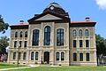
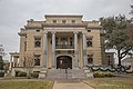
| 1912 Cameron County Courthouse †# |  | 13830 | 1150 E. Madison St. | Brownsville | 2000 | |
| 1912 Cameron County Jail† |  | 31 | 1201 E. Van Buren St. | Brownsville | 1994 | E. Van Buren at 12th Street, Brownsville |
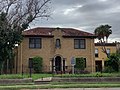
| Alonso Complex | 11776 | 510 E. St. Charles St. | Brownsville | 1998 | ||
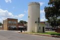
| Alta Vista Apartments | 132 | 700 Polk St. | Port Isabel | 1988 | 700 Polk Street | |
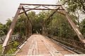
| Arroyo Colorado Lift Bridge | 17748 | W. Colorado Ave. over Arroyo Colorado | Rio Hondo | 2012 | West side of the Arroyo Colorado near bridge on FM 106 | |
| Augustine Celaya House† |  | 239 | 500 E. St. Francis St. | Brownsville | 1988 | 500 E. St. Frances Street |
| Barreda House | | 308 | 642 E. Washington St. | Brownsville | 1994 | 642 E. Washington Street |
| Browne-Wagner House† |  | 536 | 245 E. St. Charles St. | Brownsville | 1978 | 245 E. St. Charles Street |
| Brulay House |  | 18453 | 611 W. Levee St. | Brownsville | 2016 | |
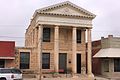
| Cameron County Courthouse of 1883-1914 |  | 640 | 1131 E. Jefferson St. | Brownsville | 1962 | 1131 E. Jefferson Street |
| Cavalry Barracks⁂ |  | 14252 | 89-93 Gorgas Dr., Texas Southmost College | Brownsville | 1987 | |
| Cavazos House |  | 768 | 608 E. Adams St. | Brownsville | 1984 | 608 E. Adams St. |
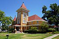
| Church of the Advent |  | 856 | 104 W. Elizabeth St. | Brownsville | 1988 | 104 W. Elizabeth Street |
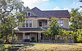
| Cisneros House |  | 866 | 451 E. Adams St. | Brownsville | 1991 | 451 E. Adams Street |
| Cisneros House |  | 18415 | 207 E. Washington St. | Brownsville | 2016 | |
| Commissary-Guard House⁂ |  | 15294 | Gorgas Dr., Texas Southmost College | Brownsville | 1965 | |
| Cueto Building (La Nueva Libertad)† |  | 1128 | 1301 E. Madison St. | Brownsville | 1985 | 13th and East Madison Streets |
| El Globo Nuevo | 18829 | 1502 E. Madison St. and 828 E. 15th St. | Brownsville | 2017 | NW corner of E Madison St & 15th St, SW corner of E Madison St and Intl Blvd, S boundary line: alley way between Intl Blvd & 15th St | |
| First Presbyterian Church of Brownsville | 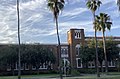 | 1830 | 435 Palm Blvd. | Brownsville | 1993 | 435 Palm Boulevard |
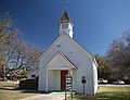
| First Presbyterian Church of San Benito | 1847 | 566 N. Reagan St. | San Benito | 1986 | 566 N. Reagan | |
| Fort Brown, Buildings 85 and 86⁂ | 1964 | Gorgas Dr., Texas Southmost College | Brownsville | 1965 | Fort Brown, Gorgas Road | |
| Fort Brown Cavalry Barracks⁂ | | 1965 | 89-93 Gorgas Dr., Texas Southmost College | Brownsville | 1987 | Fort Brown - Campus of TX Southmost College |
| Fort Brown Commissary/Guardhouse⁂ |  | 1969 | Gorgas Dr., Texas Southmost College | Brownsville | 1992 | Fort Brown - Grounds of TX Southwest College, Gorgias Street |
| Grotto of Our Lady of Lourdes | 2290 | 700 W. Jefferson St. | Brownsville | 1981 | 700 West Jefferson | |
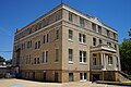
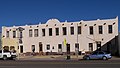
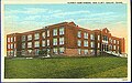
| Harlingen Hospital |  | 2382 | 2425 Boxwood St. | Harlingen | 1980 | Harlingen Industrial Air Park, off Loop 499 |
| Hicks-Gregg House† |  | 14016 | 1249 W. Washington St. | Brownsville | 2007 | 1249 W. Washington |
| Hicks-Lawrence | 14517 | 1247 Lakeside Blvd. | Brownsville | 2008 | ||
| Hinojosa House | 17718 | 235 Sunset Dr. | Brownsville | 2013 | ||
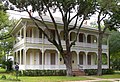
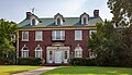
| Home of Chas. Stillman† |  | 2530 | 1305 E. Washington St. | Brownsville | 1964 | 1305 E. Washington Street |
| Howard E. and Mary Butt House | 12785 | 718 E. Taylor St. | Harlingen | 2000 | 718 E. Taylor | |
| Immaculate Conception Cathedral † |  | 2617 | 1218 E. Jefferson St. | Brownsville | 1962 | 1218 East Jefferson Street |
| Juan H. Fernandez Store | 18827 | 1200 E. Adams St. | Brownsville | 2017 | ||
| Kowalski-Dennett Home |  | 2976 | 507 E. Elizabeth St. | Brownsville | 1966 | 507 Southeast Elizabeth Street |
| Kraigher House | 18195 | 525 Paredes Line Rd. | Brownsville | 2015 | ||
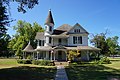
| L. E. Snavely House | 2981 | 3301 Wilson Rd. | Harlingen | 1986 | From intersection of US 77 and FM 2994, Wilson Road, in Harlingen, take FM 2994, west about .7 mile to Harlingen city limit | |
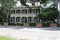
| La Madrilena† | 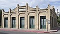 | 3000 | 1002 E. Madison St. | Brownsville | 1988 | 1000 East Madison Street |
| Landrum House | 3032 | US 281 E of FM 2520 | San Benito | 1978 | From San Benito, take FM 2520 south about 8 miles to SH 281 | |
| Launching site of first U.S. Army warplane | 3048 | 80 Fort Brown St., Texas Southmost College | Brownsville | 1966 | Fort Brown - Southmost College, Gorgias Street | |
| Lon C. Hill Home |  | 3113 | 2425 Boxwood St. | Harlingen | 1965 | Harlingen Industrial Air Park Lon C Hill Park |
| Manautou Building | 17316 | 1201 E. Washington St. | Brownsville | 2012 | Northeast corner of 12th and Washington Streets | |
| Manautou House† |  | 3196 | 5 E. Elizabeth St. | Brownsville | 1983 | S. East Elizabeth Street (at Ralim Blvd.). |
| McNair House† |  | 14711 | 39 Sunset Dr. | Brownsville | 2008 | |
| Medical Laboratory⁂ |  | 14750 | 80 Fort Brown St., Texas Southmost College | Brownsville | 1965 | |
| Morgue Building⁂ | 14083 | Gorgas Dr., Texas Southmost College | Brownsville | 1965 | ||
| Neale House |  | 3559 | 84 Neale Dr., Texas Southmost College | Brownsville | 1964 | In Ft. Brown, south end of Porter Street |
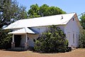
| Our Lady of Visitation Catholic Church | 3887 | 1 mi. W of Bluetown on US 281 | Santa Maria | 1977 | From Bluetown, take Highway 281 west about 1 mile | |
| Pitt House |  | 16849 | 1806 Palm Blvd. | Brownsville | 2011 | 0.1 mile north of corner of Palm Blvd. and Ringgold Street |
| Porter Cottage | 18450 | Poinsetta Place | Brownsville | 2016 | ||
| Post Hospital⁂ |  | 4086 | 80 Fort Brown St., Texas Southmost College | Brownsville | 1965 | Admin. Bldg., campus of Texas Southmost College, 80 Fort Brown |
| Post Hospital Annex⁂ |  | 4087 | 80 Fort Brown St., Texas Southmost College | Brownsville | 1962 | Admin. Bldg., Campos of Texas, Southmost College, 80 Fort Brown |
| Public Market and Town Hall | 4135 | Market Sq. | Brownsville | 1965 | Market Square and E. 11th Street | |
| Rabb Plantation | 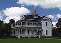 | 17140 | 8435 Sabal Palm Grove Rd. | Brownsville | 2012 | The end of Sabal Palm Road running south of FM 1792 |
| Rockwell House |  | 18828 | 110 Ebony Ave. | Brownsville | 2017 | The Cameron County Appraisal District online records describe the property as Los Ebano Subdivision Block 3, Lot 25, property ID 04-9040-000-0250-00. |
| Rosalio Longoria House | 5418 | 401 W. Magnolia Ave. | La Feria | 1974 | ||
| Russell-Cocke House |  | 12386 | 602 E. St. Charles St. | Brownsville | 2000 | |
| Sacred Heart Catholic Church |  | 12624 | 602 E. Elizabeth St. | Brownsville | 2001 | |
| San Benito Bank and Trust Company | 4526 | 198 S. Sam Houston Blvd. | San Benito | 1980 | 198 S. Sam Houston | |
| San Roman Building | 4553 | 1245 E. Elizabeth St. | Brownsville | 1966 | 1245 E. Elizabeth Street | |
| Santos Lozano Building | 4590 | 117-119 W. Jackson Ave. | Harlingen | 1980 | Pioneer Building, W. Jackson Street | |
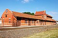
| Southern Pacific Depot† |  | 4985 | 641 E. Madison St. | Brownsville | 1985 | Historic Brownsville Museum, 641 E. Madison Street |
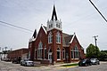
| St. Benedict's Church | 4439 | 351 S. Bowie St. | San Benito | 1978 | 351 S. Bowie | |
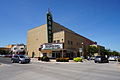
| The Gem† |  | 5344 | 400 E. 13th St. | Brownsville | 1991 | 400 East 13th Street |
| Tijerina House |  | 5491 | 333 E. Adams St. | Brownsville | 1979 | 333 E. Adams Street |
| Water District Building | 11789 | 216 S. Sam Houston Blvd. | San Benito | 1997 | ||
| Webb-Martinez House | 5735 | 1324 E. Madison St. | Brownsville | 1981 | 1324 E. Madison Street | |
| Yturria Bank | 5933 | 1255 E. Elizabeth St. | Brownsville | 1962 | 1255 E. Elizabeth Street |