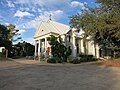
Frelsburg, Texas

Last updated
Frelsburg, Texas
Relief map of Texas.png
Red pog.svg
Frelsburg
Location within the state of Texas
Coordinates: 29°52′16″N96°32′51″W / 29.87111°N 96.54750°W / 29.87111; -96.54750 Coordinates: 29°52′16″N96°32′51″W / 29.87111°N 96.54750°W / 29.87111; -96.54750
Country United States
State Texas
County Colorado
Elevation
[1]
302 ft (92 m)
Time zone UTC-6 (Central (CST))
  Summer (DST) UTC-5 (CDT)
ZIP code
78950
Area code(s) 979

Frelsburg is an unincorporated community in Colorado County, Texas, United States. It lies at the intersection of Farm to Market Road 109 and Farm to Market Road 1291. The community was founded around 1837 by immigrants from Germany. It is home to one of the oldest surviving general stores in Texas. Continuously operated since 1865 and owned by the Heinsohn family since 1920, the store is called Heinsohn's Country Store.

Contents

Geography

Frelsburg is located at the intersection of FM 109 and FM 1291 in the northern corner of Colorado County. [2] It is between New Ulm on the east and Fayetteville on the west. [3] Its elevation is 302 ft (92 m). [1]

History

Captain William Frels and his brother John founded Frelsburg around 1837. The brothers emigrated from Germany to Texas in 1834 on the ship Congress. William Frels served in the Texian Army and donated the land for the town, school, and the Protestant church, cemetery, and parsonage. Germans from the regions of Holstein and Oldenburg settled Frelsburg so that the community merited a post office in 1847. More Germans from the Rhineland arrived and established Saints Peter and Paul Catholic Church. By 1852, the community included general stores, a cotton gin, blacksmiths, harness-makers, and small farms. After the American Civil War, cotton farming became the predominant use of agricultural land, thanks to the efforts of Frank Walls, sr. who invented an automatic distributor and cleaner for cotton gins. [2]

In 1870, an attempt to open Hermann University failed and the building was sold to the local school district instead. During the 1870s, the Galveston, Harrisburg and San Antonio Railroad passed through Columbus, 12 mi (19 km) to the south of Frelsburg and the Missouri–Kansas–Texas Railroad passed to the north. Despite missing the railroads, Frelsburg had one sawmill, three churches, four gristmills, five cotton gins, and a population of 300 in 1884. The post office closed in 1908. By the 1950s, land use changed from small farms to cattle ranching. Discovery of the Frelsburg gas field took some land out of agricultural production. From 1933 to 2000, the population of Frelsburg was reported to be 75. [2]

Businesses and churches

Notes

  1. 1 2 U.S. Geological Survey Geographic Names Information System: Frelsburg, Texas. Retrieved on October 15, 2016.
  2. 1 2 3 Carroll 2010.
  3. Google Maps 2020.

Related Research Articles

Needville, Texas City in Texas, United States

Needville is a city in Fort Bend County, Texas, United States. It is within the Houston–Sugar Land metropolitan area. The population was 2,823 at the 2010 census.

Hungerford, Texas CDP in Texas, United States

Hungerford is a census-designated place (CDP) in northeastern Wharton County, Texas, United States. U.S. Route 59, Texas State Highway 60, and Farm to Market Road 1161 intersect in the community. The Kansas City Southern Railway Co. passes through Hungerford. The population was 347 at the 2010 census. It is located on what in the 1820s was part of colonist Alexander Jackson's land grant north of George E. Quinan's home. By the 1870s, the Quinan settlement grew up a short distance away, but its residents moved to the new town when the railroad came through Hungerford.

New Ulm, Texas Unincorporated community in Texas, United States

New Ulm is an unincorporated community in Austin County, Texas, United States. According to the Handbook of Texas, the community had an estimated population of 650 in 2000. It is part of the Houston–Sugar Land–Baytown Metropolitan Statistical Area.

Ellinger, Texas City in Texas, United States

Ellinger is a city in Fayette County, Texas, United States. The population was at 203 as of 2021. It is located on the highway TX-71 about 12 miles (19 km) southeast of La Grange and 2.0 miles (3.2 km) from the Colorado County line.

Booth, Texas Unincorporated community in Texas, United States

Booth is a small unincorporated community in Fort Bend County, Texas, United States. It is located along Farm to Market Road 2759 and the BNSF Railway southeast of Richmond, Texas. There are number of houses, an RV-park, a restaurant, a landscaping business and a historical marker in the area.

High Hill, Texas

High Hill is an unincorporated community in southwestern Fayette County, Texas, United States. It is located on Farm Road 2672, three miles northwest of Schulenburg, Texas.

Black Jack Springs is a ghost town in southwestern Fayette County, Texas, United States. The community was near Farm Road 609 twelve miles southwest of La Grange in southwestern Fayette County. Named for the nearby clear springs and blackjack oak trees, Black Jack Springs was settled in the mid-1830s by Anglo pioneers.

Tavener, Texas Unincorporated community^^ in Texas, United States

Tavener is an unincorporated community in Fort Bend County, Texas, United States. It is located 4 miles (6.4 km) east-northeast of East Bernard, Texas, near the intersection of U.S. Highway 90 Alternate and Farm to Market Road 1952. Tavener no longer has its own post office, schools and railroad stop, as it once did. There is no road sign identifying the community though the Tavener Gin is prominently labeled on the north side of the Union Pacific railway line, which parallels US 90A. A small bar and grill and a number of homes can be found in the area.

Bleiblerville, Texas Unincorporated community in Texas, United States

Bleiblerville is an unincorporated community in northern Austin County, Texas, United States. According to the Handbook of Texas, its population was 71 in 2000. It is located within the Greater Houston metropolitan area.

Nelsonville, Texas Unincorporated community in Texas, United States

Nelsonville is an unincorporated community in Austin County, Texas, United States. According to the Handbook of Texas, the community had a population of 110 in 2000. It is located within the Greater Houston metropolitan area.

Farm to Market Road 109 (FM 109) is a state highway in the U.S. state of Texas. The highway begins at Business State Highway 71 (SH 71) just north of Columbus in Colorado County. It winds its way to the northeast across Austin County, passing through the communities of New Ulm and Industry before ending at State Highway 36 (SH 36) in Brenham in Washington County.

Welcome, Texas Unincorporated community in Texas, United States

Welcome is an unincorporated community in northwest Austin County, Texas, United States. According to the Handbook of Texas, the community had a population of 150 in 2000. It is located within the Greater Houston metropolitan area.

Pisek, Texas Ghost town in Texas, United States

Pisek is a ghost town in northern Colorado County, in the U.S. state of Texas. The former settlement, now a ghost town, was abandoned after 1941 when the inhabitants moved to Lone Oak on Farm to Market Road 1291. The site of Pisek is on a railroad between Fayetteville in Fayette County and New Ulm in Austin County.

Spanish Camp, Texas Unincorporated community in Texas, United States

Spanish Camp is an unincorporated community in north central Wharton County, in the U.S. state of Texas. The community is located between Egypt and Hungerford along Farm to Market Road 1161 (FM 1161) near its intersection with Farm to Market Road 640 (FM 640). After the Mexican army of Antonio López de Santa Anna camped at the site in 1836, the community took the name Spanish Camp. In 1870 a church in the community was founded by former slaves and the congregation still existed in 2013.

New Taiton, Texas Unincorporated community in Texas, United States

New Taiton is an unincorporated community in northwest Wharton County, Texas, United States. The community is situated at the intersection of State Highway 71 (SH 71) and Farm to Market Road 961 (FM 961) north-northwest of El Campo, Texas. New Taiton is identified by road signs on SH 71 and FM 961. The area around the community is intensively farmed and a number of oil and gas wells are located nearby.

Matthews, Texas Unincorporated community in Texas, United States

Matthews is an unincorporated community on the southeastern edge of Colorado County, in the U.S. state of Texas. The community is located south of Eagle Lake near the junction of FM 102 and FM 950. The settlement was named for a man who owned an area plantation before the American Civil War. By 2013, the school, post office, businesses and railroad line that once served Matthews were gone, but the number of silos in the neighborhood indicated that the land was still being intensively farmed.

Bernardo, Texas Unincorporated community in Texas, United States

Bernardo is an unincorporated community in northeast Colorado County, in the U.S. state of Texas. The small community is located on FM 949 between Interstate 10 (I-10) and Cat Spring. The town was first settled by German immigrants in the 1840s and was on a main east-west road as early as the American Civil War. Though the community once had its own post office and school, these had long disappeared by 2013. A United States Geological Survey (USGS) 7.5' x 7.5' Quadrangle Map is named Bernardo.

Mentz, Texas Unincorporated community in Texas, United States

Mentz is an unincorporated community in northeast Colorado County, in the U.S. state of Texas. It is situated northeast of Columbus on the north side of Interstate 10 (I-10). The town was first established in 1846 by German immigrants from near Mainz, Germany. The small community was still served by a Catholic Church in 2016.

{{Infobox settlement |name = Wied, Texas |settlement_type = Unincorporated area |nickname = |motto = |image_skyline = |imagesize = |image_caption = |image_flag = |image_seal = |pushpin_map = Texas#USA |pushpin_label = Wied |pushpin_image = Relief map of Texas.png |pushpin_label_position = |pushpin_map_caption = Location in Texas##Location in the United States |image_map = |mapsize = |map_caption = |image_map1 = |mapsize1 = |map_caption1 = |subdivision_type = Country |subdivision_name = United States |subdivision_type1 = State |subdivision_name1 = Texas |subdivision_type2 = County |subdivision_name2 = Lavaca |government_footnotes = |government_type = |leader_title = |leader_name = |leader_title1 = |leader_name1 = |established_title = |established_date = |population_as_of = |population_footnotes = |population_total = |population_density_km2 = |population_density_sq_mi = |timezone = Central (CST) |utc_offset = -6 |timezone_DST = CDT |utc_offset_DST = -5 |elevation_footnotes = |elevation_m = |elevation_ft = 299 |coordinates = 29°26′20″N97°03′22″W |postal_code_type = ZIP code |postal_code = 77984 |area_code = [[Area code 361 |blank_name = FIPS code |blank_info = |blank1_name = GNIS feature ID |blank1_info = 1379272 |website = |footnotes = }} Wied is an unincorporated area in west central Lavaca County in the U.S. state of Texas. It is located near U.S. Route 90 Alternate (US 90A) west of the county seat at Hallettsville. The first Anglo-American settlers arrived here in the 1830s, but by the late 1800s they were replaced by Germans and Czechs. The population declined after the 1940s. In 2018 the Vysehrad Independent School District operated an area school and a community center existed on US 90A.

References

Further reading