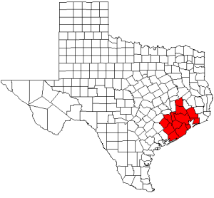
Brazoria County is a county in the U.S. state of Texas. As of the 2020 census, the population of the county was 372,031. The county seat is Angleton.

Wharton County is a county located in the U.S. state of Texas. As of the 2020 census, its population was 41,570. Its county seat is Wharton. The county was named for brothers William Harris Wharton and John Austin Wharton.

Matagorda County is a county located in the U.S. state of Texas. As of the 2020 census, its population was 36,255. Its county seat is Bay City, not to be confused with the larger Baytown in Harris and Chambers Counties. Matagorda County is named for the canebrakes that once grew along the coast.

Brazoria is a city in Brazoria County, [{Texas]], United States, and is part of the Houston–The Woodlands–Sugar Land metropolitan area. As of the 2020 census, the city population was 2,866.
West Columbia is a city in Brazoria County, Texas, United States. The city is centered on the intersection of Texas Highways 35 & 36, 55 miles (89 km) southwest of downtown Houston. The population was 3,644 at the 2020 census.

The Colorado River is an approximately 862-mile-long (1,387 km) river in the U.S. state of Texas. It is the 11th longest river in the United States and the longest river with both its source and its mouth within Texas.

The Brazos River, called the Río de los Brazos de Dios by early Spanish explorers, is the 14th-longest river in the United States at 1,280 miles (2,060 km) from its headwater source at the head of Blackwater Draw, Roosevelt County, New Mexico to its mouth at the Gulf of Mexico with a 45,000-square-mile (116,000 km2) drainage basin. Being one of the largest rivers in Texas, it is sometimes used to mark the boundary between East Texas and West Texas.

The San Bernard River is a river in Texas.
Velasco was a town in Texas, United States, that was later merged with the city of Freeport by an election conducted by eligible voters of both municipalities on February 9, 1957. The consolidation effort passed by a margin of 17 votes. Founded in 1831, Velasco is situated on the east side of the Brazos River in southeastern Texas. It is 16 miles (26 km) south of Angleton, and 4 miles (6.4 km) from the Gulf of Mexico.

Wharton County Junior College (WCJC) is a public community college with its main campus in Wharton, Texas. The college also has campuses in Richmond, Sugar Land, and Bay City.

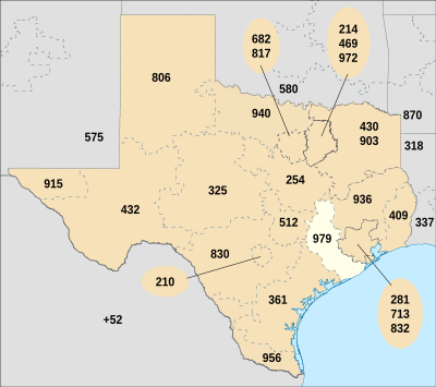
Area codes 713, 281, 832, and 346 are telephone area codes in the North American Numbering Plan (NANP) forming an overlay complex for Houston, Texas and its environs. 713 is one of the original four area codes established for Texas in 1947.
The Houston-Galveston Area Council (H-GAC) is the region-wide voluntary association of local governments in the 13-county Gulf Coast Planning Region of Texas. The organization works with local government officials to solve problems across the area. H-GAC was founded in 1966.

Caney Creek (Matagorda Bay) is a river in Texas that begins northwest of Wharton, flows generally southeast, and empties into the Gulf of Mexico near Sargent. The major waterway to the west is the Colorado River while the next major waterway to the east is the San Bernard River.

Riverstone is a 3,700-acre (15 km2) upscale master-planned residential community in Fort Bend County, Texas, United States. Approximately 18,000 residents ultimately will live in 6,000 homes. The development is largely located in unincorporated areas that are in extraterritorial jurisdictions (ETJ) of Sugar Land and Missouri City, with portions being in Missouri City proper and strips of land being in Sugar Land proper.
Port Freeport is the geographically smallest deep-water seaport along the U.S Gulf Coast. Located in Freeport, Texas , it has rail access, and both private and public facilities. It is ranked 10th in the nation for chemicals, 19th in the nation for total tonnage, 26th in the nation for container traffic, and handles over 100,000 vehicles per year and more than 1,000 ships per year. Forbes magazine (2017) ranked Port Freeport as one of the top 10 fastest growing seaports for exports in the U.S.
The 1982 Texas gubernatorial election was held on November 2, 1982, to elect the governor of Texas. Incumbent Republican governor Bill Clements ran for reelection, but was defeated in the general election by Democrat Mark White, winning 46% of the vote to White's 53%. White was sworn into office on January 18, 1983.

The U.S. state of Texas has a series of estuaries along its coast on the Gulf of Mexico, most of them bounded by the Texas barrier islands. Estuaries are coastal bodies of water in which freshwater from rivers mixes with saltwater from the sea. Twenty-one drainage basins terminate along the Texas coastline, forming a chain of seven major and five minor estuaries: listed from southwest to northeast, these are the Rio Grande Estuary, Laguna Madre, the Nueces Estuary, the Mission–Aransas Estuary, the Guadalupe Estuary, the Colorado–Lavaca Estuary, East Matagorda Bay, the San Bernard River and Cedar Lakes Estuary, the Brazos River Estuary, Christmas Bay, the Trinity–San Jacinto Estuary, and the Sabine–Neches Estuary. Each estuary is named for its one or two chief contributing rivers, excepting Laguna Madre, East Matagorda Bay, and Christmas Bay, which have no major river sources. The estuaries are also sometimes referred to by the names of their respective primary or central water bodies, though each also includes smaller secondary bays, inlets, or other marginal water bodies.