Matagorda County, Texas

Last updated

Matagorda County
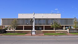
Matagorda County Texas Courthouse 2016.jpg
The Matagorda County Courthouse and Confederate Soldier Statue in Bay City
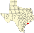
Map of Texas highlighting Matagorda County.svg
Location within the U.S. state of Texas
Texas in United States.svg
Texas's location within the U.S.
Coordinates: 28°47′N96°00′W / 28.78°N 96°W / 28.78; -96
CountryFlag of the United States.svg United States
StateFlag of Texas.svg  Texas
Founded1836
Seat Bay City
Largest cityBay City
Area
  Total1,613 sq mi (4,180 km2)
  Land1,100 sq mi (3,000 km2)
  Water512 sq mi (1,330 km2)  32%
Population
 (2020)
  Total36,255
  Density22/sq mi (8.7/km2)
Time zone UTC−6 (Central)
  Summer (DST) UTC−5 (CDT)
Congressional district 22nd
Website www.co.matagorda.tx.us
Matagorda County Office Building MatagordaCountyOfficeBuilding.JPG
Matagorda County Office Building

Matagorda County is a county located in the U.S. state of Texas. As of the 2020 census, the population was 36,255. [1] Its county seat is Bay City, [2] not to be confused with the larger Baytown in Harris and Chambers Counties. Matagorda County is named for the canebrakes that once grew along the coast (matagorda is a Spanish word meaning "thick bush").

Contents

Matagorda County comprises the Bay City, TX Micropolitan Statistical Area, which is also included in the Houston-The Woodlands, TX combined statistical area.

Geography

According to the U.S. Census Bureau, the county has a total area of 1,613 square miles (4,180 km2), of which 1,100 square miles (2,800 km2) are land and 512 square miles (1,330 km2) (32%) are covered by water. [3] The water area includes Matagorda Bay. It borders the Gulf of Mexico.

Major highways

Adjacent counties

National protected areas

Demographics

Historical population
CensusPop.Note
1850 2,124
1860 3,45462.6%
1870 3,377−2.2%
1880 3,94016.7%
1890 3,9851.1%
1900 6,09753.0%
1910 13,597123.0%
1920 16,58922.0%
1930 17,6786.6%
1940 20,06613.5%
1950 21,5597.4%
1960 25,74419.4%
1970 27,9138.4%
1980 37,82835.5%
1990 36,928−2.4%
2000 37,9572.8%
2010 36,702−3.3%
2020 36,255−1.2%
U.S. Decennial Census [4]
1850–2010 [5] 2010 [6] 2020 [7]
Matagorda County, Texas - Demographic Profile
(NH = Non-Hispanic)
Race / EthnicityPop 2010 [6] Pop 2020 [7] % 2010% 2020
White alone (NH)17,40015,35547.41%42.35%
Black or African American alone (NH)4,0603,73411.06%10.30%
Native American or Alaska Native alone (NH)104990.28%0.27%
Asian alone (NH)6937001.89%1.93%
Pacific Islander alone (NH)770.02%0.02%
Some Other Race alone (NH)331030.09%0.28%
Mixed Race/Multi-Racial (NH)3318020.90%2.21%
Hispanic or Latino (any race)14,07415,45538.35%42.63%
Total36,70236,255100.00%100.00%

Note: the US Census treats Hispanic/Latino as an ethnic category. This table excludes Latinos from the racial categories and assigns them to a separate category. Hispanics/Latinos can be of any race.

As of the census [8] of 2000, 37,957 people, 13,901 households, and 9,925 families were residing in the county. The population density was 34 people per square mile (13 people/km2). The 18,611 housing units averaged 17 units per square mile (6.6/km2). The racial makeup of the county was 67.83% White, 12.72% African American, 0.67% Native American, 2.38% Asian, 14.02% from other races, and 2.38% from two or more races. About 31.35% of the population were Hispanic or Latino of any race. By ancestry, 10.3% were of German, 8.2% American, 5.4% English, and 5.2% Irish according to Census 2000, and 73.9% spoke English, 24.0% Spanish, and 1.6% Vietnamese as their first language.

Of the 13,901 households, 36.70% had children under the age of 18 living with them, 53.80% were married couples living together, 12.70% had a female householder with no husband present, and 28.60% were not families. About 25.10% of all households were made up of individuals, and 10.40% had someone living alone who was 65 years of age or older. The average household size was 2.70, and the average family size was 3.25.

In the county, the age distribution was 30.00% under the age of 18, 8.90% from 18 to 24, 26.90% from 25 to 44, 21.80% from 45 to 64, and 12.40% who were 65 years of age or older. The median age was 35 years. For every 100 females, there were 98.60 males. For every 100 females age 18 and over, there were 95.50 males.

The median income for a household in the county was $32,174, and for a family was $40,586. Males had a median income of $37,733 versus $21,871 for females. The per capita income for the county was $15,709. About 14.90% of families and 18.50% of the population were below the poverty line, including 23.00% of those under age 18 and 13.60% of those age 65 or over.
Economy

Matagorda County Museum in Bay City is located across from the Court House. Matagorda County Museum in Bay City.jpg
Matagorda County Museum in Bay City is located across from the Court House.

Rice is grown extensively in Matagorda County, as are St. Augustine and other turf grasses. In addition to a wealth of offshore oil rigs and natural gas extraction facilities all over the county, two petrochemical processing plants (Celanese and Equistar) and the South Texas Project nuclear power plant operate within the county. Matagorda County has secluded, extensive forests, wetlands, prairie, and coastal regions. The Gulf Coast floodplain has several conditions conducive to a variety of ecosystems and recreational activities evident by the highest count of migrating birds in the United States. Fishing (on- and offshore), hunting, and scuba diving are large parts of the recreation industry due to the Colorado River, the forests and Matagorda Bay. The Rio Colorado Golf Course and a birdwatching park are on the Colorado River near the State Highway 35 bridge, and a significant number of wildlife preserves are located around the county, a portion of which is land bought for that purpose by the two major petrochemical refineries and nuclear plant in the county.

Education

School districts serving Matagorda County include:

Communities

Cities

Census-designated places

Unincorporated communities

Ghost towns

Notable people

Politics

United States presidential election results for Matagorda County, Texas [12]
Year Republican Democratic Third party
No.%No.%No.%
2020 9,84571.72%3,73327.19%1491.09%
2016 8,36668.60%3,50028.70%3302.71%
2012 8,04066.27%3,98032.80%1130.93%
2008 7,83563.32%4,44035.88%980.79%
2004 8,11964.84%4,35534.78%470.38%
2000 7,58460.87%4,69637.69%1791.44%
1996 5,87647.03%5,37443.01%1,2449.96%
1992 5,32840.47%4,75936.15%3,07823.38%
1988 6,78754.01%5,67545.16%1040.83%
1984 8,45261.72%5,20137.98%410.30%
1980 5,54553.41%4,58544.16%2522.43%
1976 3,67942.14%4,97156.94%810.93%
1972 5,00366.75%2,47333.00%190.25%
1968 3,09436.55%3,59542.46%1,77720.99%
1964 2,40736.72%4,14363.20%50.08%
1960 2,97549.60%2,97149.53%520.87%
1956 3,92766.46%1,90432.22%781.32%
1952 4,12266.23%2,10133.76%10.02%
1948 1,01630.80%1,62849.35%65519.85%
1944 41213.43%1,85460.45%80126.12%
1940 65123.14%2,15676.64%60.21%
1936 45921.21%1,70078.56%50.23%
1932 40816.58%2,03982.85%140.57%
1928 1,19458.85%82940.86%60.30%
1924 89337.62%1,35356.99%1285.39%
1920 91843.90%99247.44%1818.66%
1916 25223.10%74868.56%918.34%
1912 1079.64%71063.96%29326.40%

See also

Related Research Articles

<span class="mw-page-title-main">Wilbarger County, Texas</span> County in Texas, United States

Wilbarger County is a county located in the North Texas region of the U.S. state of Texas. As of the 2020 census, the population was 12,887. The county seat is Vernon. The county was created in 1858 and later organized in 1881. Wilbarger is named for Josiah Pugh Wilbarger and Mathias Wilbarger, two early settlers.

<span class="mw-page-title-main">Trinity County, Texas</span> County in Texas, United States

Trinity County is a county located in the U.S. state of Texas. As of the 2020 census, the population was 13,602. Its county seat is Groveton. The county is named for the Trinity River.

<span class="mw-page-title-main">San Jacinto County, Texas</span> County in Texas, United States

San Jacinto County is a county in the U.S. state of Texas. As of the 2020 census, its population was 27,402. Its county seat is Coldspring. The county's name comes from the Battle of San Jacinto which secured Texas' independence from Mexico and established a republic in 1836.

<span class="mw-page-title-main">San Augustine County, Texas</span> County in Texas, United States

San Augustine County is a county located in the U.S. state of Texas. As of the 2020 census, its population was 7,918. Its county seat is San Augustine.

<span class="mw-page-title-main">Robertson County, Texas</span> County in Texas, United States

Robertson County is a county in the U.S. state of Texas. As of the 2020 census, its population was 16,757. Its county seat is Franklin. The county was created in 1837 and organized the following year. It is named for Sterling C. Robertson, an early settler who signed the Texas Declaration of Independence.

<span class="mw-page-title-main">Oldham County, Texas</span> County in Texas, United States

Oldham County is a county located in the U.S. state of Texas. As of the 2020 census, its population was 1,758. Its county seat is Vega. The county was created in 1876 and organized in 1881. Oldham County is included in the Amarillo, TX Metropolitan Statistical Area.

<span class="mw-page-title-main">Nueces County, Texas</span> County in Texas, United States

Nueces County is located in the U.S. state of Texas. As of the 2020 census, the population was 353,178, making it the 16th-most populous county in the state. The county seat is Corpus Christi. The county was formed in 1846 from portions of San Patricio County and organized the following year. It is named for the Nueces River, which marks the county's northwestern boundary with San Patricio County before emptying into its mouth at Nueces Bay north of the port of Corpus Christi. Nueces County is part of the Corpus Christi metropolitan statistical area.

<span class="mw-page-title-main">Nacogdoches County, Texas</span> County in Texas, United States

Nacogdoches County is a county located in the U.S. state of Texas. As of the 2020 census, its population was 64,653. Its county seat is Nacogdoches.

<span class="mw-page-title-main">Medina County, Texas</span> County in Texas, United States

Medina County is a county located in the U.S. state of Texas. As of the 2020 census, its population was 50,748. Its county seat is Hondo. The county is named for the Medina River. The extreme northern part of the county lies within the Edwards Plateau, which elevates into the Texas Hill Country. The Medina Dam, the fourth largest in the nation when completed in 1913, is listed on the National Register of Historic Places. The irrigation project, creating Medina Lake, was built by 1500 skilled workers who worked in shifts operating 24 hours a day to complete the dam in two years. Medina County is part of the San Antonio, TX Metropolitan Statistical Area.

<span class="mw-page-title-main">Lubbock County, Texas</span> County in Texas, United States

Lubbock County is a county located in the U.S. state of Texas. The 2020 census placed the population at 310,639. Its county seat and largest city is Lubbock. The county was created in 1876 and organized in 1891. It is named for Thomas Saltus Lubbock, a Confederate colonel and Texas Ranger.

<span class="mw-page-title-main">Live Oak County, Texas</span> County in Texas, United States

Live Oak County is a county in the U.S. state of Texas. It was named for its native groves of live oak. George West is its county seat. Its population was 11,335 in the 2020 census.

<span class="mw-page-title-main">Lavaca County, Texas</span> County in Texas, United States

Lavaca County is a county located in the U.S. state of Texas. As of the 2020 census, its population was 20,337. Its county seat is Hallettsville. The county was created in 1846. It is named for the Lavaca River, which curves its way southeast through Moulton and Hallettsville before reaching the coast at Matagorda Bay.

<span class="mw-page-title-main">Karnes County, Texas</span> County in Texas, United States

Karnes County is a county in the U.S. state of Texas. As of the 2020 census, the population was 14,710. Its county seat is Karnes City. The county is named for Henry Karnes, a soldier in the Texas Revolution. The former San Antonio and Aransas Pass Railway passed through Karnes County in its connection linking San Antonio with Corpus Christi.

<span class="mw-page-title-main">Hockley County, Texas</span> County in Texas, United States

Hockley County is a county located in the U.S. state of Texas. As of the 2020 census, its population was 21,537. Its county seat is Levelland. The county was created in 1876, but not organized until 1921. It is named for George Washington Hockley, a secretary of war of the Republic of Texas.

<span class="mw-page-title-main">Fayette County, Texas</span> County in Texas, United States

Fayette County is a county located in the U.S. state of Texas. As of the 2020 census, the population was 24,435. Its county seat is La Grange. The county was created in 1837 and organized the next year.

<span class="mw-page-title-main">Dawson County, Texas</span> County in Texas, United States

Dawson County is a county in the U.S. state of Texas. As of the 2020 census, its population was 12,456. The county seat is Lamesa. The county was created in 1876 and later organized in 1905. It is named for Nicholas Mosby Dawson, a soldier of the Texas Revolution. Dawson County comprises the Lamesa, TX Micropolitan Statistical Area (μSA), and it is, by population, the smallest Micropolitan Statistical Area in the United States.

<span class="mw-page-title-main">Castro County, Texas</span> County in Texas, United States

Castro County is a county located in the U.S. state of Texas. As of the 2020 census, its population was 7,371. Its county seat is Dimmitt. The county was named for Henri Castro, who was consul general to France for the Republic of Texas and the founder of a colony in Texas.

<span class="mw-page-title-main">Calhoun County, Texas</span> County in Texas, United States

Calhoun County is a county located in the U.S. state of Texas. As of the 2020 census, the population was 20,106. Its county seat is Port Lavaca. The county is named for John Caldwell Calhoun, the seventh vice president of the United States. Calhoun County comprises the Port Lavaca, TX Micropolitan Statistical Area, which is also included in the Victoria-Port Lavaca, TX Combined Statistical Area.

<span class="mw-page-title-main">Palacios, Texas</span> City in Texas, United States

Palacios is a city in Matagorda County, Texas, United States. The population was 4,395 at the 2020 census.

<span class="mw-page-title-main">Van Vleck, Texas</span> CDP in Texas, United States

Van Vleck is a census-designated place (CDP) in Matagorda County, Texas, United States. The population total represents one of the few areas with positive growth in Matagorda County. The 2010 census showed a 25% increase with 1,844 people. Although near Bay City, the site of Van Vleck falls outside the ETJ of Bay City and is regulated by county police and county ordinance.

References

  1. "Matagorda County, Texas". United States Census Bureau . Retrieved February 23, 2021.
  2. "Find a County". National Association of Counties. Retrieved June 7, 2011.
  3. "2010 Census Gazetteer Files". United States Census Bureau. August 22, 2012. Retrieved May 4, 2015.
  4. "Decennial Census of Population and Housing by Decades". US Census Bureau.
  5. "Texas Almanac: Population History of Counties from 1850–2010" (PDF). Texas Almanac. Archived (PDF) from the original on October 9, 2022. Retrieved May 4, 2015.
  6. 1 2 "P2 HISPANIC OR LATINO, AND NOT HISPANIC OR LATINO BY RACE - 2010: DEC Redistricting Data (PL 94-171) - Matagorda County, Texas". United States Census Bureau .
  7. 1 2 "P2 HISPANIC OR LATINO, AND NOT HISPANIC OR LATINO BY RACE - 2020: DEC Redistricting Data (PL 94-171) - Matagorda County, Texas". United States Census Bureau .
  8. "U.S. Census website". United States Census Bureau . Retrieved May 14, 2011.
  9. JENKINS, RACHEL (June 15, 2010). "HAWLEY, TX". tshaonline.org. Retrieved March 22, 2018.
  10. Lewis, Frank Hawkins (February 1979). "Evolution of an Early Texas Ranch". Rangelands. 1 (1): 6–8. JSTOR   3900331.
  11. "Was Craig Watkins the first black DA in Texas? Historians find evidence of another". February 23, 2019.
  12. Leip, David. "Dave Leip's Atlas of U.S. Presidential Elections". uselectionatlas.org.

Commons-logo.svg Media related to Matagorda County, Texas at Wikimedia Commons

28°47′N96°00′W / 28.78°N 96.00°W / 28.78; -96.00