Ashwood, Texas | |
---|---|
Coordinates: 29°06′15″N95°52′17″W / 29.10417°N 95.87139°W | |
Country | United States |
State | Texas |
County | Matagorda |
Elevation | 56 ft (17 m) |
Time zone | UTC-6 (Central (CST)) |
• Summer (DST) | UTC-5 (CDT) |
ZIP code | 77482 |
Area code | 979 |
GNIS feature ID | 1379368 [1] |
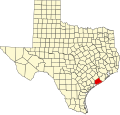
Ashwood is a small unincorporated community in Matagorda County, Texas, United States. [1] It is located at the intersection of FM 1728 and County Road 112. The community was established when a railroad was built through the area around 1900. It had a post office between 1910 and 1952 when it closed.
Ashwood is along FM 1728 about 13 miles (21 km) north of Bay City in northeastern Matagorda County. [2] Caney Creek flows south on the west side of the community. [3]
The New York, Texas and Mexican Railway reached Ashwood about 1899–1900 when a branch was built from Wharton to Van Vleck. In its early days, ash logs were shipped from the settlement. In 1910, a post office opened and Mittie D. Hanson was postmaster. In 1914 there were 87 residents and the community had a general store and a mill. Annie M. Smith became the postmaster in 1916 and continued to hold the position until the post office was closed in 1952. Smith also operated the express office and the J. Fisher Smith Mercantile Store. In 1917 Ashwood had a one-room schoolhouse with four grades. In 1925 the population had grown to 200. By the mid-1930s there were two schools, a church, and one business in the community. In 1938 there was a school for African-American children with two teachers. Ashwood's population dropped to 100 in 1942 and to 20 by 1950. By 1967 there were 30 residents and by 2000 there were about 100. [2]
Van Vleck is a census-designated place (CDP) in Matagorda County, Texas, United States. The population total represents one of the few areas with positive growth in Matagorda County. The 2010 census showed a 25% increase with 1,844 people. Although near Bay City, the site of Van Vleck falls outside the ETJ of Bay City and is regulated by county police and county ordinance.
Boling-Iago is a census-designated place (CDP) in Wharton County, Texas, United States. The population was 1,271 as of the 2000 United States Census. Boling-Iago is located along Farm to Market Road 1301 about 10 miles (16 km) southeast of Wharton, the county seat. Boling is located at the intersection of FM 1301 and Farm to Market Road 442, while the community of Iago is 1.5 miles (2.4 km) to the northeast at the intersection of FM 1301 and Farm to Market Road 1096. The Boling Independent School District received a Recognized ranking in 2010. The numerous pump jacks and oil tanks in the vicinity indicate that Boling and Iago lie atop oil-bearing rock formations.
New Caney is an unincorporated community in Montgomery County, Texas, United States, located within the Houston–The Woodlands–Sugar Land metropolitan area. As of 2010, the population of the New Caney area is 19,987. New Caney had an estimated population in 2016 of roughly 22,000.
Sargent is a small unincorporated community located in the eastern corner of Matagorda County, Texas, United States.
Tarpley is an unincorporated community in Bandera County, Texas, United States. According to the Handbook of Texas, the community had a population of 30 in 2000. It is part of the San Antonio Metropolitan Statistical Area.
Caney is an unincorporated community in Matagorda County, Texas, United States.
Cedar Lane is an unincorporated community in Matagorda County, Texas, United States.
Hawkinsville was a community in Matagorda County, Texas, United States. In 2018, there were a few homes nearby, several businesses one mile to the south, and the name appeared on maps, but one source refers to the place in the past tense, while a second source states that the town disappeared in the 1950s. The town site is between Cedar Lane and Sargent.
Egypt is an unincorporated community in northern Wharton County in the U.S. state of Texas. According to the Handbook of Texas, the community had a population of 26 in 2000. It is located within the Greater Houston metropolitan area.
Caney Creek (Matagorda Bay) is a river in Texas that begins northwest of Wharton, flows generally southeast, and empties into the Gulf of Mexico near Sargent. The major waterway to the west is the Colorado River while the next major waterway to the east is the San Bernard River.
Fredonia is an unincorporated community in Mason County, Texas, United States. The community is located near the county line of Mason and San Saba counties, where State Highway 71 intersects with Ranch to Market Road 386. Fredonia has a post office, with the ZIP code 76842.
Nelsonville is an unincorporated community in Austin County, Texas, United States. According to the Handbook of Texas, the community had a population of 110 in 2000. It is located within the Greater Houston metropolitan area.
Nottawa is a ghost town in northeastern Wharton County, in the U.S. state of Texas. The former community was situated in a rice-growing area midway between East Bernard and Lissie at the junction of U.S. Route 90 Alternate (US 90A) and Farm to Market Road 1164 (FM 1164). There was a gas compressor station on the site in 2016.
Matthews is an unincorporated community on the southeastern edge of Colorado County, in the U.S. state of Texas. The community is located south of Eagle Lake near the junction of FM 102 and FM 950. The settlement was named for a man who owned a plantation in the area before the Civil War. By 2013, the school, post office, businesses and railroad line that once served Matthews were gone, but the number of silos in the neighborhood indicated that the land was still being intensively farmed.
Burr, also known as Lawson's Corner or Kriegel Switch, is an unincorporated community in eastern Wharton County, in the U.S. state of Texas. The small community is situated on Farm to Market Road 1301 (FM 1301) to the east of the county seat at Wharton. The settlement was first established just before the Civil War, when two plantations were set up in the area. In the 1890s, it was a thriving community, but by the 1940s it had begun to dwindle. In 2013, a few businesses and several homes and farms were in the area.
Peach Creek is a ghost town in Wharton County in the U.S. state of Texas. The former settlement was located along Peach Creek in the land grants belonging to Old Three Hundred settlers William Kincheloe and Alexander Jackson, Sr. During the Republic of Texas a post office was located at Peach Creek. Though it was hoped the community might become the county seat, that never happened and postal service stopped in 1847.
Preston is a ghost town in Wharton County in the U.S. state of Texas. The one-time settlement was located in the land grant belonging to Old Three Hundred settler John Huff near an important north–south trail. During the early years of the Republic of Texas, lots were sold and a town took shape. Postal service began in 1839 and ceased in 1857. The only evidence that a town existed is an old cemetery near Farm to Market Road 1096, (FM 1096) south of Iago.
Don-Tol is a small unincorporated community in southeastern Wharton County, in the U.S. state of Texas. The community is located along FM 1301 southeast of Boling. There is a Don-Tol sign on FM 1301 at County Road 100. The name was used by Mexican workers to address William Toliver Taylor, the owner of a post-Civil War sugar cane plantation.
Edge is an unincorporated community in Brazos County, Texas, United States. According to the Handbook of Texas, the community had a population of 100 in 2000. It is located within the Bryan-College Station metropolitan area.
Buckhorn is an unincorporated community in Austin County, in the U.S. state of Texas. According to the Handbook of Texas, its population was 20 in 2000. It is located within the Greater Houston metropolitan area.