Nolan County, Texas

Last updated

Nolan County
Nolan County Texas Courthouse 2015.jpg
Nolan County Courthouse
Map of Texas highlighting Nolan County.svg
Location within the U.S. state of Texas
Texas in United States.svg
Texas's location within the U.S.
Coordinates: 32°19′N100°24′W / 32.31°N 100.4°W / 32.31; -100.4
CountryFlag of the United States.svg United States
StateFlag of Texas.svg  Texas
Founded1881
Named for Philip Nolan
Seat Sweetwater
Largest citySweetwater
Area
  Total914 sq mi (2,370 km2)
  Land912 sq mi (2,360 km2)
  Water2.0 sq mi (5 km2)  0.2%
Population
 (2020)
  Total14,738
  Density16/sq mi (6.2/km2)
Time zone UTC−6 (Central)
  Summer (DST) UTC−5 (CDT)
Congressional district 19th
Website www.co.nolan.tx.us

Nolan County is a county located in the west-central region of the U.S. state of Texas. As of the 2020 census, its population was 14,738. [1] Its county seat is Sweetwater. [2] The county was created in 1876 and organized in 1881. [3] It is named for Philip Nolan, one of the first American traders to visit Texas. Nolan County comprises the Sweetwater micropolitan statistical area.

Contents

Geography

According to the U.S. Census Bureau, the county has a total area of 914 square miles (2,370 km2), of which 2.0 sq mi (5.2 km2) (0.2%) are covered by water. [4]

Nolan County is in the Cross Timbers region for wildlife management. [5] Geologically Nolan County occupies part of the Rolling Plains in the North and South, [6] separated by an isolated part of the Edwards Plateau [7] in much of the center. The uplifted plateau, rising up to 500 [8] feet above the surrounding plains, gives Nolan county an advantage on production of wind energy.

West of Highland School, the Bench Mountain, at 2607 feet above sea level, is listed as the highest point in Nolan County.

Plateau areas of the Cretaceous Period [7] and much of the county are underlain by petroleum deposits from the Pennsylvanian Period. [9]

Major highways

Adjacent counties

Demographics

Historical population
CensusPop.Note
1880 640
1890 1,573145.8%
1900 2,61166.0%
1910 11,999359.6%
1920 10,868−9.4%
1930 19,32377.8%
1940 17,309−10.4%
1950 19,80814.4%
1960 18,963−4.3%
1970 16,220−14.5%
1980 17,3597.0%
1990 16,594−4.4%
2000 15,802−4.8%
2010 15,216−3.7%
2020 14,738−3.1%
U.S. Decennial Census [10]
1850–2010 [11] 2010 [12] 2020 [13]
Nolan County, Texas – Racial and ethnic composition
Note: the US Census treats Hispanic/Latino as an ethnic category. This table excludes Latinos from the racial categories and assigns them to a separate category. Hispanics/Latinos may be of any race.
Race / Ethnicity (NH = Non-Hispanic)Pop 2000 [14] Pop 2010 [12] Pop 2020 [13] % 2000% 2010% 2020
White alone (NH)10,4809,1918,13866.32%60.40%55.22%
Black or African American alone (NH)7136666254.51%4.38%4.24%
Native American or Alaska Native alone (NH)2544530.16%0.29%0.36%
Asian alone (NH)33581030.21%0.38%0.70%
Pacific Islander alone (NH)1020.01%0.00%0.01%
Other race alone (NH)28310.01%0.05%0.21%
Mixed race or Multiracial (NH)1171464320.74%0.96%2.93%
Hispanic or Latino (any race)4,4315,1035,35428.04%33.54%36.33%
Total15,80215,21614,738100.00%100.00%100.00%

As of the census [15] of 2000, 15,802 people, 6,170 households, and 4,288 families resided in the county. The population density was 17 people per square mile (6.6 people/km2). The 7,112 housing units averaged 8 units per square mile (3.1 units/km2). The racial makeup of the county was 78.45% White, 4.68% Black or African American, 0.49% Native American, 0.24% Asian, 0.06% Pacific Islander, 14.02% from other races, and 2.07% from two or more races. About 28.04% of the population was Hispanic or Latino of any race.

Of the 6,170 households, 32.20% had children under 18 living with them, 53.00% were married couples living together, 12.60% had a female householder with no husband present, and 30.50% were not families. Around 27.10% of all households were made up of individuals, and 13.40% had someone living alone who was 65 or older. The average household size was 2.48, and the average family size was 3.01.

In the county, the population was distributed as 27.10% under 18, 8.50% from 18 to 24, 25.40% from 25 to 44, 22.60% from 45 to 64, and 16.40% who were 65 or older. The median age was 37 years. For every 100 females, there were 94.70 males. For every 100 females age 18 and over, there were 91.70 males.

The median income for a household in the county was $26,209, and for a family was $32,004. Males had a median income of $28,674 versus $19,335 for females. The per capita income for the county was $14,077. About 18.30% of families and 21.70% of the population were below the poverty line, including 29.50% of those under age 18 and 18.50% of those age 65 or over.
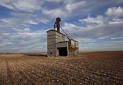
Wind power

Nolan County has established itself as a center for wind power generation. As of July 2008, Nolan County generated more wind energy than the entire state of California, and would have ranked sixth in the world for wind power generation if it were counted as its own country. [16] In 2013, there were more than 13,000 operational wind turbines. [17]

A branch of Texas State Technical College, near Sweetwater, offers the first community-college program for wind energy in Texas beginning in 2007. Wind energy investments in the county of about $3 billion since 1999 have resulted in about 1,330 direct wind-related jobs created in Nolan County alone (in 2009), with almost $18,000,000 in annual landowner royalties and over $12,000,000 in annual local school taxes (2007), [18] and about $1.7 million more in county property taxes. The majority of investments come from Epplament Energy, E.ON, Invenergy, Lestis Private Capital Group, NextEra, and Lattner Energy.

Nolan County is a hub of the Public Utility Commission's $5 billion CREZ wind-energy transmission line expansion project in Texas. [19]

Communities

Abandoned grain elevator in Wastella Wastella Texas grain elevator 2011.jpg
Abandoned grain elevator in Wastella

Cities

Unincorporated communities

Ghost towns

Politics

Nolan County is part of the 71st district for elections to the Texas House of Representatives. The Republican state representative Stan Lambert represents the district which also covers Callahan, Jones and Taylor Counties. [23]

United States presidential election results for Nolan County, Texas [24]
Year Republican Democratic Third party(ies)
No.%No.%No.%
2020 4,13177.11%1,16221.69%641.19%
2016 3,55273.13%1,02921.19%2765.68%
2012 3,28271.74%1,21626.58%771.68%
2008 3,48568.83%1,52130.04%571.13%
2004 3,72270.37%1,54129.14%260.49%
2000 3,33762.82%1,87435.28%1011.90%
1996 2,16640.18%2,58247.89%64311.93%
1992 1,99333.48%2,49041.83%1,46924.68%
1988 2,73448.74%2,85350.86%220.39%
1984 3,60858.80%2,52441.13%40.07%
1980 2,78148.83%2,79649.10%1182.07%
1976 2,43143.84%3,09455.80%200.36%
1972 3,63473.03%1,33826.89%40.08%
1968 1,96933.16%2,78446.88%1,18519.96%
1964 1,61031.19%3,54068.58%120.23%
1960 2,42142.66%3,24757.22%70.12%
1956 2,23246.69%2,53553.03%130.27%
1952 2,90748.11%3,12351.68%130.22%
1948 55213.57%3,40883.76%1092.68%
1944 3228.59%3,07181.96%3549.45%
1940 47112.41%3,31487.35%90.24%
1936 2688.39%2,91391.15%150.47%
1932 2198.19%2,45391.70%30.11%
1928 1,47558.76%1,03541.24%00.00%
1924 33718.32%1,42177.23%824.46%
1920 17515.16%92379.98%564.85%
1916 917.47%1,04885.97%806.56%
1912 607.34%65580.17%10212.48%

Education

School districts include: [25]

The Texas Legislature designated the county as being in the Western Texas College District. [26]

See also

Related Research Articles

<span class="mw-page-title-main">Wise County, Texas</span> County in Texas, United States

Wise County is a county in the U.S. state of Texas. As of the 2020 census, its population was 68,632. Its county seat is Decatur. Wise County is part of the Dallas–Fort Worth–Arlington metropolitan statistical area. Its Wise Eyes crime-watch program, eventually adopted by mostly rural counties in several states, was started in 1993 by then-Sheriff Phil Ryan.

<span class="mw-page-title-main">Wilbarger County, Texas</span> County in Texas, United States

Wilbarger County is a county located in the North Texas region of the U.S. state of Texas. As of the 2020 census, the population was 12,887. The county seat is Vernon. The county was created in 1858 and later organized in 1881. Wilbarger is named for Josiah Pugh Wilbarger and Mathias Wilbarger, two early settlers.

<span class="mw-page-title-main">Washington County, Texas</span> County in Texas, United States

Washington County is a county in Texas. As of the 2020 census, the population was 35,805. Its county seat is Brenham, which is located along U.S. Highway 290, 72 miles northwest of Houston. The county was created in 1835 as a municipality of Mexico and organized as a county in 1837. It is named for George Washington, the first president of the United States.

<span class="mw-page-title-main">Terry County, Texas</span> County in Texas, United States

Terry County is a county located in the U.S. state of Texas. As of the 2020 census, its population was 11,831. Its county seat is Brownfield. The county was demarked in 1876 and organized in 1904. It is named for Benjamin Franklin Terry, a colonel in the Confederate Army. Terry County was one of 46 dry counties in the state of Texas, but is now a moist county. Terry County is one of the most productive pumpkin producing counties in the United States.

<span class="mw-page-title-main">Taylor County, Texas</span> County in Texas, United States

Taylor County is a county located in the U.S. state of Texas. As of the 2020 census, its population was 143,208. Its county seat is Abilene. The county was created in 1858 and later organized in 1878. It is named for Edward Taylor, George Taylor, and James Taylor, three brothers who died at the Battle of the Alamo.

<span class="mw-page-title-main">Scurry County, Texas</span> County in Texas, United States

Scurry County is a county located in the U.S. state of Texas. As of the 2020 census, its population was 16,932. Its county seat is Snyder, which is the home for Western Texas College. Scurry County is named for Confederate General William Scurry. The county was created in 1876 and organized in 1884. Scurry County was one of 46 prohibition, or entirely dry, counties in the state of Texas, until a 2006 election approved the sale of beer and wine in Snyder, and a 2008 election approved the sale of liquor by the drink throughout the county.

<span class="mw-page-title-main">Oldham County, Texas</span> County in Texas, United States

Oldham County is a county located in the U.S. state of Texas. As of the 2020 census, its population was 1,758. Its county seat is Vega. The county was created in 1876 and organized in 1881. Oldham County is included in the Amarillo, TX Metropolitan Statistical Area.

<span class="mw-page-title-main">Jones County, Texas</span> County in Texas, United States

Jones County is a county located in the U.S. state of Texas. As of the 2020 census, its population was 19,663. Its county seat is Anson. The county was created in 1858 and organized in 1881. Both the county and its county seat are named for Anson Jones, the fourth and final president of the Republic of Texas.

<span class="mw-page-title-main">Floyd County, Texas</span> County in Texas, United States

Floyd County is a county in the U.S. state of Texas. As of the 2020 census, its population was 5,402. The seat of the county is Floydada. The county was created in 1876 and later organized in 1890. It is named for Dolphin Ward Floyd, who died on his 32nd birthday, March 6, 1836, defending the Alamo.

<span class="mw-page-title-main">Fisher County, Texas</span> County in Texas, United States

Fisher County is a county located in the U.S. state of Texas. As of the 2020 census, its population was 3,672. The county seat is Roby. The county was created in 1876 and later organized in 1886. It is named for Samuel Rhoads Fisher, a signer of the Texas Declaration of Independence and a Secretary of the Navy of the Republic of Texas. Fisher County was one of 30 prohibition, or entirely dry, counties in Texas, but is now a fully wet county.

<span class="mw-page-title-main">Comanche County, Texas</span> County in Texas, United States

Comanche County is a county located on the Edwards Plateau in Central Texas. As of the 2020 census, its population was 13,594. The county seat is Comanche. The county was founded in 1856 and is named for the Comanche Native American tribe.

<span class="mw-page-title-main">Belton, Texas</span> City in Texas, United States

Belton is a city in the U.S. state of Texas. Belton is the county seat of Bell County and is the fifth largest city in the Killeen-Temple metropolitan area. In 2020, the population of Belton was 23,054, and the metro region had a population of 450,051 according to US Census estimates.

<span class="mw-page-title-main">Rosenberg, Texas</span> City in Texas, United States

Rosenberg is a city in the U.S. state of Texas, within the Houston–The Woodlands–Sugar Land metropolitan area and Fort Bend County. Rosenberg was named for Henry Von Rosenberg, who emigrated to Texas from Switzerland in 1843. Von Rosenberg was an important figure in the settlement of Fort Bend County and the Gulf Coast region. The population was 38,282 at the 2020 census, up from 30,618 at the 2010 census. The community holds the Fort Bend County fair in October. Rosenberg is adjacent to the city of Richmond, the Fort Bend County seat.

<span class="mw-page-title-main">Wolfforth, Texas</span> City in Texas, United States

Wolfforth is a town located in Lubbock County, Texas, United States. It is a southwestern suburb of Lubbock. The population was 5,521 at the 2020 census.

<span class="mw-page-title-main">Stanton, Texas</span> City in Texas, United States

Stanton is a city in and the county seat of Martin County, Texas, United States. Stanton was founded as Marienfeld by German immigrants that were some of the first settlers in this region of Texas. The population was 2,657 at the 2020 census.

<span class="mw-page-title-main">Goodlow, Texas</span> City in Texas, United States

Goodlow is a city in Navarro County, Texas, United States. Its population was 178 in the 2020 census.

<span class="mw-page-title-main">Roscoe, Texas</span> City in Texas, United States

Roscoe is a city in Nolan County in the U.S. state of Texas near the intersection of Interstate 20 and US Highway 84. The Union Pacific Railroad passes through the center of the city. The population was 1,271 at the 2020 census.

<span class="mw-page-title-main">Sweetwater, Texas</span> City in Texas, United States

Sweetwater is a municipality in and the seat of Nolan County, Texas, United States. It is 123 miles southeast of Lubbock and 40 miles west of Abilene. Its population was 10,622 at the 2020 census.

Agua Dulce is a city in Nueces County, in the U.S. state of Texas. It is located on the Texas Mexican Railway at the intersection of State Highway 44 and Farm to Market Road 70 in west-central Nueces County. The name, Spanish for "sweet water", refers to a nearby creek. A town in Texas, Sweetwater in Nolan County in West Texas, uses the English name.

<span class="mw-page-title-main">Burkburnett, Texas</span> City in Texas, United States

Burkburnett is a city in Wichita County, Texas, United States. It is part of the Wichita Falls, Texas metropolitan statistical area. Its population was 10,939 at the 2020 census.

References

  1. "Nolan County, Texas". United States Census Bureau . Retrieved February 23, 2021.
  2. "Find a County". National Association of Counties. Retrieved June 7, 2011.
  3. "Texas: Individual County Chronologies". Texas Atlas of Historical County Boundaries. The Newberry Library. 2008. Retrieved May 25, 2015.
  4. "2010 Census Gazetteer Files". United States Census Bureau. August 22, 2012. Retrieved May 5, 2015.
  5. "North Central Texas Wildlife Management". tpwd.texas.gov. Retrieved March 26, 2024.
  6. "TPWD: Ecological Regions of North Central Texas". tpwd.texas.gov. Retrieved March 26, 2024.
  7. 1 2 "TPWD:Edwards Plateau". tpwd.texas.gov. Retrieved March 26, 2024.
  8. "Worldwide Elevation Finder". elevation.maplogs.com. Retrieved March 26, 2024.
  9. "ABSTRACT: Canyon (Pennsylvanian) Sand Prospecting in Nolan County, Texas, Using Electrotelluric Survey Methods, by Robert B. Lanter and Michael R. Birkos; #91037 (2010)". www.searchanddiscovery.com. Retrieved March 26, 2024.
  10. "Decennial Census of Population and Housing by Decade". US Census Bureau.
  11. "Texas Almanac: Population History of Counties from 1850–2010" (PDF). Texas Almanac. Archived (PDF) from the original on October 9, 2022. Retrieved May 5, 2015.
  12. 1 2 "P2 Hispanic or Latino, and Not Hispanic or Latino by Race – 2010: DEC Redistricting Data (PL 94-171) – Nolan County, Texas". United States Census Bureau .
  13. 1 2 "P2 Hispanic or Latino, and Not Hispanic or Latino by Race – 2020: DEC Redistricting Data (PL 94-171) – Nolan County, Texas". United States Census Bureau .
  14. "P004: Hispanic or Latino, and Not Hispanic or Latino by Race – 2000: DEC Summary File 1 – Nolan County, Texas". United States Census Bureau .
  15. "U.S. Census website". United States Census Bureau . Retrieved May 14, 2011.
  16. Reed, Dan (July 11, 2008). "Texas oilman T. Boone Pickens wants to supplant oil with wind". USA Today.
  17. Selcraig, Bruce (July–August 2014). "The Mayor of Wind". Sierra Club. Retrieved July 2, 2020.
  18. Wind Economics In Nolan County https://www.scribd.com/doc/280240711/nolan-county-case-study-070908 accessed November 19, 2018
  19. "Renewable Energy". Sweetwater Economic Development. Retrieved March 26, 2024.
  20. TSHA, Support. "Hylton TX (Nolan County)". TSHA Online. TSHA. Retrieved February 3, 2020.
  21. Ghost Town https://tshaonline.org/handbook/online/articles/hvd13 accessed November 19, 2018
  22. TSHA, Support. "Divide TX (Nolan County)". TSHA Online. TSHA. Retrieved February 3, 2020.
  23. "Susan King". Texas Legislative Reference Library. Retrieved March 12, 2014.
  24. Leip, David. "Dave Leip's Atlas of U.S. Presidential Elections". uselectionatlas.org. Retrieved July 28, 2018.
  25. "2020 CENSUS - SCHOOL DISTRICT REFERENCE MAP: Nolan County, TX" (PDF). U.S. Census Bureau . Retrieved September 22, 2024. - Text list
  26. "Sec. 130.210. WESTERN TEXAS COLLEGE DISTRICT SERVICE AREA" . Retrieved September 22, 2024.

32°19′N100°24′W / 32.31°N 100.40°W / 32.31; -100.40