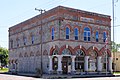
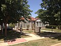
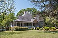
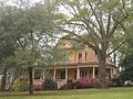
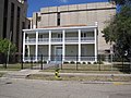
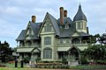
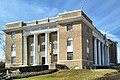
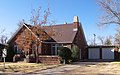
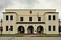
List of Recorded Texas Historic Landmarks (Mason-Rusk)

Last updated

The following is a partial list of Recorded Texas Historic Landmarks (RTHLs) arranged by county as designated by the Texas Historical Commission and local county historical commissions in Texas. This page includes RTHLs in the following counties: Mason, Matagorda, Maverick, McCulloch, McLennan, McMullen, Medina, Menard, Midland, Milam, Mills, Mitchell, Montague, Montgomery, Moore, Morris, Motley, Nacogdoches, Navarro, Newton, Nolan, Nueces, Ochiltree, Oldham, Orange, Palo Pinto, Panola, Parker, Parmer, Pecos, Polk, Potter, Presidio, Rains, Randall, Reagan, Real, Red River, Reeves, Refugio, Roberts, Robertson, Rockwall, Runnels, and Rusk.

Contents

Recorded Texas Historic Landmarks listed by county
Anderson-CallahanCameron-DuvalEastland-GrayGrayson-HudspethHunt-Martin • Mason-Rusk • Sabine-TravisTrinity-Zavala

KEY

Map all coordinates using: OpenStreetMap

Landmarks with multiple historic designations are colored according to their highest designation within the following hierarchy.

⁕ Listed individually on the National Register of Historic Places (NRHP) as a National Historic Landmark
⁂ Listed on the NRHP as a contributing property of a National Historic Landmark District
Listed individually on the NRHP
Listed as a contributing property of an NRHP Historic District
§ Listed individually as or as part of a State Historic Site
# Listed individually as or as part of a State Antiquities Landmark

Mason County

Registered Texas Historic LandmarkImageMarker numberPhysical addressNearest cityYear designatedDescription
Art Methodist Church 11266 Art-Hedwigs Hill Rd. S of SH 29

30°44′15″N99°7′12″W / 30.73750°N 99.12000°W / 30.73750; -99.12000

Art 1968Off Art-Hedwig Rd
Art Schoolhouse 11267 Lower Willow Creek Rd. S of SH 29

30°44′3″N99°6′43″W / 30.73417°N 99.11194°W / 30.73417; -99.11194

Art 1968From Art take Lower Willowcreek Rd. south approx. 400 yds.
Bethel M. E. Church 11269 5840 Loeffler Ln.

30°35′14″N99°6′41″W / 30.58722°N 99.11139°W / 30.58722; -99.11139

Mason vicinity1965take US 87 approx. 10 miles south to RR 783; then approx. 4.2 miles south on RR 783 to Loeffler Lane; then 0.2 mile east
Broad Street Bridge 3-4 VIEW FROM SE. - Broad Street Bridge, Spanning Comanche Creek at Broad Street, Mason, Mason County, TX HAER TX,160-MASON,1-3.tif
Commons-logo.svg More images
12047 Broad St. over Comanche Creek

30°45′9″N99°13′53″W / 30.75250°N 99.23139°W / 30.75250; -99.23139

Mason 1998Broad Street at Comanche Creek
First Christian Church 11272 100 Willow St.

30°44′52″N99°13′29″W / 30.74778°N 99.22472°W / 30.74778; -99.22472

Mason 1973Corner of Austin St. and Willow St.
Holmes & Bierschwale Law and Land Office 12510 421 McKavett St.

30°44′59″N99°14′5″W / 30.74972°N 99.23472°W / 30.74972; -99.23472

Mason 2000(McKavett St. is also US 87 N)
Mason County Courthouse # Mason County Courthouse.jpg
Commons-logo.svg More images
11286 Courthouse Square S of W. Austin St.

30°44′56″N99°13′27″W / 30.74889°N 99.22417°W / 30.74889; -99.22417

Mason 1988Courthouse Square
Mason County Jail 11287 S of Westmoreland St. between Moody St. and Post Hill St.

30°44′51″N99°13′55″W / 30.74750°N 99.23194°W / 30.74750; -99.23194

Mason 1983Corner of Westmoreland and Post Hill St.
Mason House Hotel & Stage Station 12048 NE corner Austin St. at N. Live Oak St.

30°44′57″N99°13′51″W / 30.74917°N 99.23083°W / 30.74917; -99.23083

Mason 1999Live Oak and SH 29, Mason
Old Mason Grammar School 11289 SE corner Schmidt St. at Post Hill St.

30°44′42″N99°13′54″W / 30.74500°N 99.23167°W / 30.74500; -99.23167

Mason 1965Corner of Post Hill and Schmidt St.
Rudolph and Therese Runge House 13029 916 San Antonio St.

30°44′28″N99°13′22″W / 30.74111°N 99.22278°W / 30.74111; -99.22278

Mason 2003916 San Antonio
Seaquist Home Reynolds seaquist house.jpg 11293 400 Broad St.

30°45′5″N99°13′54″W / 30.75139°N 99.23167°W / 30.75139; -99.23167

Mason 1974Corner of Broad and Lotus streets
Spring Street Church 11295 403 Spring St.

30°45′7″N99°14′0″W / 30.75194°N 99.23333°W / 30.75194; -99.23333

Mason 1989Spring St. at Bluebird
St. Paul Lutheran Church 11292 102 Magnolia St.

30°44′53″N99°13′42″W / 30.74806°N 99.22833°W / 30.74806; -99.22833

Mason 1972
Taylor-Carter House 12049 610 N. Robin Ave.

30°45′17″N99°14′17″W / 30.75472°N 99.23806°W / 30.75472; -99.23806

Mason 1999
The Lindsay House 11284 516 Spring St.

30°45′11″N99°14′0″W / 30.75306°N 99.23333°W / 30.75306; -99.23333

Mason 1984

Matagorda County

Registered Texas Historic LandmarkImageMarker numberPhysical addressNearest cityYear designatedDescription
Bandstand 295 2000 Sixth St.

28°58′54″N95°57′57″W / 28.98167°N 95.96583°W / 28.98167; -95.96583

Bay City 19672000 Sixth Street, Bay City
Bay City U.S.O. Building Bay City Texas USO Building.jpg 12050 2105 Ave. M

28°59′4″N95°57′44″W / 28.98444°N 95.96222°W / 28.98444; -95.96222

Bay City 1999
Blessing State Bank Blessing State Bank, Blessing, Texas (21694854683).jpg
Commons-logo.svg More images
12054 SE corner Ave. B at N. Tenth St.

28°52′18″N96°13′17″W / 28.87167°N 96.22139°W / 28.87167; -96.22139

Blessing 1997corner of Avenue B and 10th Street, Blessing
Cates-Price House 12061 506 S. Bay Blvd.

28°41′58″N96°13′3″W / 28.69944°N 96.21750°W / 28.69944; -96.21750

Palacios 1998
Christ Episcopal Church Christ Episcopal Church, Matagorda, TX.jpg 840 206 Cypress St.

28°41′33″N95°58′3″W / 28.69250°N 95.96750°W / 28.69250; -95.96750

Matagorda 1962southeast corner of Cypress and Lewis; Matagorda
D. P. and Louise Moore House 1145 2404 Ave. E

28°58′46″N95°58′18″W / 28.97944°N 95.97167°W / 28.97944; -95.97167

Bay City 19942404 Avenue E, Bay City
Dale-Rugeley-Sisk Home ca. 1830 1157 751 Catalpa St.

28°41′33″N95°57′52″W / 28.69250°N 95.96444°W / 28.69250; -95.96444

Matagorda 1964southeast corner of Fisher and Catalpa; Matagorda
Fisher-Sargent-Gottschalk House 1901 107 St. Mary St.

28°41′16″N95°58′22″W / 28.68778°N 95.97278°W / 28.68778; -95.97278

Matagorda 1991107 St. Mary, Matagorda
Hawkins Lake Home 2410 S of FM 521 near Lake Austin

28°49′40″N95°47′35″W / 28.82778°N 95.79306°W / 28.82778; -95.79306

Wadsworth 1962SH 60 18 southeast from Bay City to FM 521; then 3 1/2 miles south to Lake Austin

(Private Property) - Not Surveyed

Hensley - Gusman House Hensley-Gusman House, Bay City, TX.jpg 2455 2120 Sixth St.

28°58′56″N95°57′52″W / 28.98222°N 95.96444°W / 28.98222; -95.96444

Bay City 19942120 6th Street, Bay City
Holman House Judge William Shields Holman House.jpg 2511 2504 Ave. K

28°58′43″N95°57′51″W / 28.97861°N 95.96417°W / 28.97861; -95.96417

Bay City 19942504 Avenue K, Bay City
Home of Horace Yeamans 2538 S of FM 521 W of Cashs Creek

28°47′18″N96°11′41″W / 28.78833°N 96.19472°W / 28.78833; -96.19472

Palacios 1965from missing go east on SH 35 approximately 6 miles; then north on FM 521 approximately 1 mile
Hotel Blessing Hotel Blessing, Blessing, Texas (22169719072).jpg
Commons-logo.svg More images
2570 128 N. Tenth St.

28°52′17″N96°13′19″W / 28.87139°N 96.22194°W / 28.87139; -96.22194

Blessing 1965corner 10th and FM 616; Blessing
Kilbridge - Barkley House 2938 1704 Third St.

28°58′42″N95°58′10″W / 28.97833°N 95.96944°W / 28.97833; -95.96944

Bay City 19941704 3rd Street, Bay City
Luther Hotel Luther Hotel Palacios Texas.jpg 3149 408 S. Bay Blvd.

28°41′58″N96°12′57″W / 28.69944°N 96.21583°W / 28.69944; -96.21583

Palacios 1965408 South Bay, Palacios (between 4th and 6th Streets)
M. S. and Cora Alice Perry House 12067 2504 Ave. I

28°58′43″N95°58′0″W / 28.97861°N 95.96667°W / 28.97861; -95.96667

Bay City 1997
Masonic Lodge #411 Masonic Lodge 411, Blessing, Texas Historical Marker (22348163946).jpg
Commons-logo.svg More images
3243 619 Ave. B

28°52′34″N96°13′8″W / 28.87611°N 96.21889°W / 28.87611; -96.21889

Blessing 1965southeast corner of 11th and FM 616; Blessing
Old Bay City Bank 3689 2044 Ave. F

28°58′59″N95°58′13″W / 28.98306°N 95.97028°W / 28.98306; -95.97028

Bay City 1965corner (northwest) of FM 60 and SH 35, Bay City or 2044 Avenue F, Bay City
Old Matagorda Post Office 3763 SW corner Laurel St. at Fisher St.

28°41′20″N95°58′18″W / 28.68889°N 95.97167°W / 28.68889; -95.97167

Matagorda 1965northeast corner of Fisher and Laurel; Matagorda
Price-Farwell House Price Farwell House Palacios Texas.jpg 13282 300 S. Bay Blvd.

28°41′55″N96°12′50″W / 28.69861°N 96.21389°W / 28.69861; -96.21389

Palacios 2004300 S Bay
Pybus-Koerber House 13244 208 Main St.

28°42′6″N96°12′46″W / 28.70167°N 96.21278°W / 28.70167; -96.21278

Palacios 2004208 Main St
R. J. Hill Building Hill Building Palacios Texas.jpg 12436 401 Commerce St.

28°42′1″N96°12′54″W / 28.70028°N 96.21500°W / 28.70028; -96.21500

Palacios 2000
Rugeley Building (Old City Bank) 15246 2044 Ave. F

28°58′59″N95°58′13″W / 28.98306°N 95.97028°W / 28.98306; -95.97028

Bay City 1965
Sargent-Rugeley-Herreth House 18099 3224 Ave. K

28°58′14″N95°57′50″W / 28.97056°N 95.96389°W / 28.97056; -95.96389

Bay City 2015
St. Francis Catholic 5031 105 mi. W on FM 521

28°48′26″N95°57′13″W / 28.80722°N 95.95361°W / 28.80722; -95.95361

Wadsworth 1965from Wadsworth go west on SH 521 approximately 1.5 miles
The A. B. Pierce Home 5283 366 Ave. C

28°52′9″N96°13′27″W / 28.86917°N 96.22417°W / 28.86917; -96.22417

Blessing 1968corner of 8th and Avenue C; Blessing
The Culver Home 5317 1001 Wightman St.

28°41′40″N95°58′2″W / 28.69444°N 95.96722°W / 28.69444; -95.96722

Matagorda 1967northeast corner of Wightman and Caney Street, Matagorda
The F. Cornelius House 5330 E end of CR 450 at Juanita Creek

28°57′19″N96°11′12″W / 28.95528°N 96.18667°W / 28.95528; -96.18667

Midfield 1971from Midfield go north on SH 71 approximately 2 miles; 120 east on one lane paved road approximately 2 miles (turns to dirt road approximately .5 miles from house)
W.C. Williams Building 18282 456 Commerce St.

28°42′2″N96°13′0″W / 28.70056°N 96.21667°W / 28.70056; -96.21667

Palacios 2015
Yeamans-Stallard House 14498 S of FM 521 W of Cashs Creek

28°47′18″N96°11′41″W / 28.78833°N 96.19472°W / 28.78833; -96.19472

Palacios 1965

Maverick County

Registered Texas Historic LandmarkImageMarker numberPhysical addressNearest cityYear designatedDescription
Church of the Redeemer Episcopal Church of the Redeemer, Eagle Pass, TX IMG 1989.JPG 862 648 Madison St.

28°42′48″N100°30′11″W / 28.71333°N 100.50306°W / 28.71333; -100.50306

Eagle Pass 1978648 Madison Street, Eagle Pass
Dos Chimeneas Ranch House 18547 17703-18509 US 277 Eagle Pass 2016
Eagle Pass Post Office 1328 589 E. Main St.

28°42′31″N100°30′3″W / 28.70861°N 100.50083°W / 28.70861; -100.50083

Eagle Pass 1996589 Main Street, Eagle Pass
Maverick County Courthouse# MAVERICK COUNTY COURTHOUSE.jpg
Commons-logo.svg More images
3261 501 E. Main St.

28°42′32″N100°30′5″W / 28.70889°N 100.50139°W / 28.70889; -100.50139

Eagle Pass 1971Courthouse lawn
S. P. Simpson Jr. House 4402 597 N. Ceylon St.

28°42′46″N100°30′3″W / 28.71278°N 100.50083°W / 28.71278; -100.50083

Eagle Pass 1972597 Ceylon Street (door reads 597 at bottom, but 419 at top)
The Lee Building 5370 400 Bliss St.

28°42′9″N100°30′10″W / 28.70250°N 100.50278°W / 28.70250; -100.50278

Eagle Pass 1968Adams Street on right 1 block past hospital

McCulloch County

Registered Texas Historic LandmarkImageMarker numberPhysical addressNearest cityYear designatedDescription
Camp San Saba Masonic Lodge 678 10 mi. S of Brady near FM 1955 Brady vicinity1962FM 1955, in Camp San Saba community; about 10 miles south of Brady via US 87
East Sweden Presbyterian Church 1367 CR 414 at CR 412

31°9′59″N99°15′25″W / 31.16639°N 99.25694°W / 31.16639; -99.25694

Brady vicinity1989From Brady take US 190 5.5 miles northeast, then turn east on CR 412. Church is at junction with CR 414. Destroyed by fire March 20, 2022.
McCulloch County Courthouse # Mcculloch county courthouse 2010.jpg
Commons-logo.svg More images
3286 199 Courthouse Sq.

31°8′6″N99°20′5″W / 31.13500°N 99.33472°W / 31.13500; -99.33472

Brady 1967Courthouse square, US 87/377 at US 190
McCulloch County Jail Old mcculloch county jail.jpg 3287 117 N. High St.

31°8′7″N99°20′12″W / 31.13528°N 99.33667°W / 31.13528; -99.33667

Brady 1976
Ogden Home 3679 10 mi. S of Brady near FM 1955 Brady vicinity196210 miles south of Brady on US 377/87 in the Camp San Saba community
Union Passenger Depot Union Passenger Depot Brady Texas.jpg
Commons-logo.svg More images
5597 505 N. Bridge St.

31°8′21″N99°20′9″W / 31.13917°N 99.33583°W / 31.13917; -99.33583

Brady 1984North Bridge Street

McLennan County

Registered Texas Historic LandmarkImageMarker numberPhysical addressNearest cityYear designatedDescription
Albert Turner Clifton House 103 2600 Austin Ave.

31°32′22″N97°9′4″W / 31.53944°N 97.15111°W / 31.53944; -97.15111
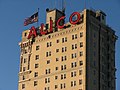
Waco 19912600 Austin (26th Austin)
Alico Building ALICO Building.jpg
Commons-logo.svg More images
118 425 Austin Ave.

31°33′25″N97°7′55″W / 31.55694°N 97.13194°W / 31.55694; -97.13194
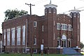
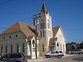
Waco 1982425 Austin Ave. (4th Austin), Waco
Austin Avenue Methodist Church Waco June 2016 53 (Austin Avenue United Methodist Church).jpg
Commons-logo.svg More images
241 1300 Austin Ave.

31°33′0″N97°8′20″W / 31.55000°N 97.13889°W / 31.55000; -97.13889
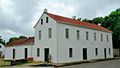
Waco 19901300 Austin Ave. (13th Austin), Waco
Bagby House 274 1825 S. Eighth St.

31°32′27″N97°7′7″W / 31.54083°N 97.11861°W / 31.54083; -97.11861
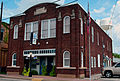
Waco 19831825 S. 8th (corner of S. 8th St. and Wood Ave) - razed in 2014
Best Theatre Building Best theater building 2013.jpg
Commons-logo.svg More images
386 218 N. Main St.

31°48′11″N97°5′30″W / 31.80306°N 97.09167°W / 31.80306; -97.09167

West 1994218 N Main
Bull Hide Creek Iron Bridge 14774 W of I-35 over Bull Hide Creek between Lorena and Hewitt

31°25′2″N97°11′59″W / 31.41722°N 97.19972°W / 31.41722; -97.19972

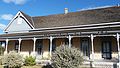
Waco 1994
Deyerle-Fall House 12118 917 Old Oglesby Rd.

31°26′8″N97°26′19″W / 31.43556°N 97.43861°W / 31.43556; -97.43861

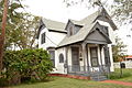
McGregor 1998
Earle-Harrison House 1334 1901 N. Fifth St.

31°34′9″N97°8′53″W / 31.56917°N 97.14806°W / 31.56917; -97.14806
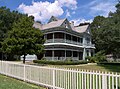
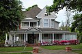
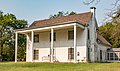
Waco 19701901 N. 5th St., Waco
Earle-Napier-Kinnard House Earle napier kinnard house 2009.jpg 1335 814 S. Fourth St.

31°34′43″N97°7′21″W / 31.57861°N 97.12250°W / 31.57861; -97.12250

Waco 1969814 S. 4th (at corner of 4th & I-35), Waco
East Terrace John wesley mann house.jpg 1368 100 Mill St.

31°34′2″N97°8′1″W / 31.56722°N 97.13361°W / 31.56722; -97.13361

Waco 1962100 Mill Ave. (corner of Mill and Lake Brazos Dr; House faces Lake Brazos Dr.), Waco
Eddy Methodist Church 1386 404 W. Third St.

31°17′49″N97°15′22″W / 31.29694°N 97.25611°W / 31.29694; -97.25611
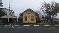
Eddy 1993Corner of SH 107 and Ausborn St., Eddy
Elite Cafe 1454 2132 S. Valley Mills Dr.

31°31′29″N97°7′58″W / 31.52472°N 97.13278°W / 31.52472; -97.13278

Waco 19942132 S. Valley Mills Dr. (on the Circle Off I-35), Waco
First Lutheran Church 1736 1008 Jefferson Ave.

31°33′19″N97°8′23″W / 31.55528°N 97.13972°W / 31.55528; -97.13972

Waco 19841008 Jefferson (10th & Jefferson), Waco
Flowers House 12121 600 W. Third St.

31°17′51″N97°15′27″W / 31.29750°N 97.25750°W / 31.29750; -97.25750
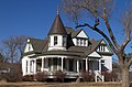
Eddy 1998600 W. Third Street
Forsgard House ForsgardHomestead1.JPG
Commons-logo.svg More images
12905 1122 N. Fourth St.

31°33′51″N97°8′24″W / 31.56417°N 97.14000°W / 31.56417; -97.14000

Waco 20021122 North Fourth
Fort House Fort house waco 2009.jpg
Commons-logo.svg More images
1990 503 S. Fourth St.

31°33′14″N97°7′35″W / 31.55389°N 97.12639°W / 31.55389; -97.12639
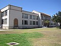
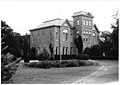
Waco 1969503 South 4th St.
George W. Carroll Science Hall 16017 1401 S. Fifth St.

31°32′47″N97°7′13″W / 31.54639°N 97.12028°W / 31.54639; -97.12028

Waco 2009
Glenn and Mary Gulledge Crain House 12897 705 S. Adams St.

31°26′3″N97°24′26″W / 31.43417°N 97.40722°W / 31.43417; -97.40722
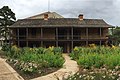
McGregor 2002705 S. Adams St
Groppe Barn 2288 SE on private road from FM 3149 at Groppe Rd.

31°44′26″N97°3′55″W / 31.74056°N 97.06528°W / 31.74056; -97.06528

West 1991From West, take Main St. south from center of town one mile, take Cemetery Rd. east, go 2.5 more miles to Barn
Groppe Building Groppe bldg 2013.jpg
Commons-logo.svg More images
2289 130 N. Main St.

31°48′8″N97°5′31″W / 31.80222°N 97.09194°W / 31.80222; -97.09194

West 1983130 N. Main (Corners of Main & Oak), West.
H. J. and Cora Hudson House 18674 306 S. Bordon St.

31°23′1″N97°12′56″W / 31.38361°N 97.21556°W / 31.38361; -97.21556
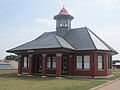
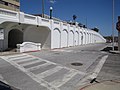
Lorena 2017Behind sidewalk in front (to the east) of the H. J. and Cora Hudson House on 306 South Bordon Street in Lorena, Texas
H. & T. C. Railroad 2311 Off S. Martin Luther King, Jr. Blvd. between Taylor St. and E. Bridge St.

31°33′45″N97°7′30″W / 31.56250°N 97.12500°W / 31.56250; -97.12500

Waco 1966N/A
Hill House 2483 901 Ave. E

31°18′20″N97°21′46″W / 31.30556°N 97.36278°W / 31.30556; -97.36278
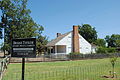
Moody 1989901 Ave. E, Moody
Hoyle Cabin 2507 421 Rice Ave.

31°34′43″N97°9′10″W / 31.57861°N 97.15278°W / 31.57861; -97.15278

Waco 1963421 Rice Ave on western edge of Cameron Park in Waco (on private property)
Johnson-Taylor House 2838 1705 N. Fifth St.

31°34′5″N97°8′47″W / 31.56806°N 97.14639°W / 31.56806; -97.14639

Waco 19631705 N. 5th St., Waco (corner of 5th & Garland); (also called Nell Pape Garden Center)
Kuykendall House 2978 300 Estelle Rice St.

31°18′26″N97°21′51″W / 31.30722°N 97.36417°W / 31.30722; -97.36417
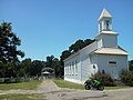
Moody 1979corner of Estelle Rice & Ave. F., Moody
Lorena United Methodist Church Lorena United Methodist Church 2018.jpg
Commons-logo.svg More images
5372 205 S. Bordon St.

31°23′4″N97°12′54″W / 31.38444°N 97.21500°W / 31.38444; -97.21500

Lorena 1976Corner of Borden & Bettie Sts., Lorena
Lusk House 3148 301 Jefferson Ave.

31°33′42″N97°8′2″W / 31.56167°N 97.13389°W / 31.56167; -97.13389
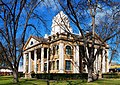
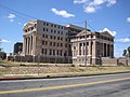
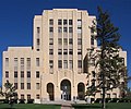
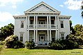
Waco 1965301 Jefferson (3rd & Jefferson), Waco
McLennan County Courthouse # Waco June 2016 16 (McLennan County Courthouse).jpg
Commons-logo.svg More images
3302 501 Washington Ave.

31°33′26″N97°8′1″W / 31.55722°N 97.13361°W / 31.55722; -97.13361

Waco 1970Between 5th and 6th on Washington, Waco (Courthouse Square)
Old Main Burleson.jpg 16018 1411 S. Fifth St.

31°32′45″N97°7′13″W / 31.54583°N 97.12028°W / 31.54583; -97.12028

Waco 2009
Old Walker Homestead 3829 3401 Dever Dr.

31°34′2″N97°11′11″W / 31.56722°N 97.18639°W / 31.56722; -97.18639

Waco 1969
Rotan-Dosset House Rotan dossett house 2009.jpg
Commons-logo.svg More images
4358 1503 Columbus Ave.

31°33′1″N97°8′35″W / 31.55028°N 97.14306°W / 31.55028; -97.14306

Waco 19781503 Columbus (15th & Columbus), Waco
Saint Paul's Episcopal Church 4482 501 Columbus Ave.

31°33′31″N97°8′5″W / 31.55861°N 97.13472°W / 31.55861; -97.13472

Waco 1963501 Columbus (5th Columbus), Waco
St. James United Methodist Church 4444 600 S. Second St.

31°33′19″N97°7′26″W / 31.55528°N 97.12389°W / 31.55528; -97.12389

Waco 1986600 S. 2nd (2nd & clay St.), Waco
Stratton-Stricker Building 18271 800 Austin Ave.

31°33′15″N97°8′4″W / 31.55417°N 97.13444°W / 31.55417; -97.13444

Waco 2015Southwest corner of 8th and Austin, on sidewalk facing Austin Avenue
The C. C. McCulloch House Mcculloch house waco 2009.jpg
Commons-logo.svg More images
5397 406 Columbus Ave.

31°33′32″N97°7′58″W / 31.55889°N 97.13278°W / 31.55889; -97.13278
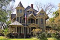
Waco 1979(4th & Columbus), Waco
The Cottonland Castle 5314 3300 Austin Ave.

31°32′1″N97°9′28″W / 31.53361°N 97.15778°W / 31.53361; -97.15778
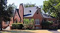
Waco 19773300 Austin Avenue
The George Butler - Jesse Harrison House 2154 1018 Taylor Ave.

31°34′12″N97°7′9″W / 31.57000°N 97.11917°W / 31.57000; -97.11917

Waco 1971
The Howard House 5356 800 Ave. E

31°18′23″N97°21′47″W / 31.30639°N 97.36306°W / 31.30639; -97.36306

Moody 1978800 Ave. E, Moody
The Isaac Jackson Teague Property 5358 172 Teague Dr.

31°17′50″N97°21′47″W / 31.29722°N 97.36306°W / 31.29722; -97.36306

Moody 1976From Moody take 1/2 mile south on Highway 317, east of 317 and south of cemetery.
The Sims Cabin 5427 1020 Sleepy Hollow Rd.

31°30′16″N97°14′1″W / 31.50444°N 97.23361°W / 31.50444; -97.23361

Waco 1963on private property in the Woodway Neighborhood, .
The Sturgis House Waco June 2016 37 (Sturgis House).jpg 5433 1316 Washington Ave.

31°33′2″N97°8′26″W / 31.55056°N 97.14056°W / 31.55056; -97.14056

Waco 1971across from St. Mary's
W. H. Janes Home 5672 N of FM 308 W of Fajkus Rd.

31°45′16″N97°0′44″W / 31.75444°N 97.01222°W / 31.75444; -97.01222

Leroy 1981From Leroy 2 mi E on FM 2311, off-road on southside (private property)
Waco Theatre Waco June 2016 62 (Hippodrome).jpg
Commons-logo.svg More images
5694 724 Austin Ave.

31°33′16″N97°8′3″W / 31.55444°N 97.13417°W / 31.55444; -97.13417

Waco 1981
Watson Feed Store Watson feed store mart tx.jpg 15253 308 E. Texas Ave.

31°32′29″N96°50′5″W / 31.54139°N 96.83472°W / 31.54139; -96.83472

Mart 2003
Wesley United Methodist Church 18221 125 Turner St.

31°34′6″N97°7′22″W / 31.56833°N 97.12278°W / 31.56833; -97.12278

Waco 2015Northeast corner of Turner St and Elm, directly behind the old Bailsbondsman building on Elm St.

McMullen County

Registered Texas Historic LandmarkImageMarker numberPhysical addressNearest cityYear designatedDescription
Dog Town Jail 1242 204 Elm St.

28°27′39″N98°32′56″W / 28.46083°N 98.54889°W / 28.46083; -98.54889

Tilden 1966Behind courthouse, located at intersection of Highway 72 and Highway 16, Tilden.
Old Rock Store Tilden-tx2017-11(old-rock-store).jpg
Commons-logo.svg More images
3799 502 River St.

28°27′41″N98°32′59″W / 28.46139°N 98.54972°W / 28.46139; -98.54972

Tilden 1966Faces courthouse across from courthouse on Route 16 at intersection with Highway 72, Tilden.

Medina County

Registered Texas Historic LandmarkImageMarker numberPhysical addressNearest cityYear designatedDescription
Arcadius Steinle House 186 1416 Florella St.

29°21′31″N98°52′44″W / 29.35861°N 98.87889°W / 29.35861; -98.87889

Castroville 19621416 Florella St.
Cordier-Tschirhart-Seal House 1058 1213 Isabella St.

29°21′29″N98°52′34″W / 29.35806°N 98.87611°W / 29.35806; -98.87611

Castroville 1976Intersection of Paris/Isabella, Castroville.
Dolch-Hans Compound 13252 1213 Fiorella St.

29°21′26″N98°52′37″W / 29.35722°N 98.87694°W / 29.35722; -98.87694

Castroville 20041213-1215 Fiorella Street
Dubuis House Castroville-tx(dubuis-house)2016-2.jpg
Commons-logo.svg More images
1291 1207 Angelo St.

29°21′20″N98°52′42″W / 29.35556°N 98.87833°W / 29.35556; -98.87833

Castroville 1966On Angelo Street across from St. Louis Church, Castroville.
F. Xavier Schmidt House Castroville-tx(schmidt-house)2016-2.jpg
Commons-logo.svg More images
1523 714 Lisbon St.

29°21′29″N98°52′34″W / 29.35806°N 98.87611°W / 29.35806; -98.87611

Castroville 1966Corner of Lisbon and Naples, Castroville.
Family Home of George T. Briscoe 1566 402 W. Hondo Ave.

29°8′32″N98°54′31″W / 29.14222°N 98.90861°W / 29.14222; -98.90861

Devine 1977402 West Hondo Street, Devine.
First Church in Castroville Castroville-tx(st-louis-church)2016-2.jpg
Commons-logo.svg More images
14895 1208 Angelo St.

29°21′19″N98°52′43″W / 29.35528°N 98.87861°W / 29.35528; -98.87861

Castroville 1966
Fohn-Bless Store Hondo-tx(bless-store)2016-2.jpg
Commons-logo.svg More images
1934 1020 18th St.

29°20′55″N99°8′26″W / 29.34861°N 99.14056°W / 29.34861; -99.14056

Hondo 19741020 Eighteenth Street, Hondo.
Fred Metzger House 377 1003 16th St.

29°21′0″N99°8′24″W / 29.35000°N 99.14000°W / 29.35000; -99.14000

Hondo 19641003 Sixteenth Street, Hondo.
Gallagher Ranch House 2100 Private road south of SH 16 near Bexar County line

29°36′15″N98°48′36″W / 29.60417°N 98.81000°W / 29.60417; -98.81000

Helotes 1967From San Antonio, take SH 16 about 23 mi NW to Bexar, Medina Co. Line-house on private property.
J. M. Koch's Hotel J.M Koch Hotel, which used to be an old railroad hotel in the little town of D'Hanis in Medina County, Texas, is now a guest house LCCN2014631301.tif 12357 1906 Sacarosa Ave.

29°19′54″N99°16′46″W / 29.33167°N 99.27944°W / 29.33167; -99.27944

D'Hanis 2000on FM 1796 (Main Street), 1 block north of US 90, D'Hanis
Landmark Inn §# Landmark Inn 2016.jpg
Commons-logo.svg More images
3031 402 Florence St.

29°21′16″N98°52′28″W / 29.35444°N 98.87444°W / 29.35444; -98.87444

Castroville 1965Intersection of Highway 90 and Florence Street, Castroville.
Leinweber Building 3068 1706 Ave. M

29°20′57″N99°8′31″W / 29.34917°N 99.14194°W / 29.34917; -99.14194

Hondo 1986M Street on downtown plaza, Highway 90, Hondo.
Louis Haller House Castroville-tx2016-91(louis-haller-house).jpg
Commons-logo.svg More images
3135 1307 Fiorella St.

29°21′28″N98°52′39″W / 29.35778°N 98.87750°W / 29.35778; -98.87750

Castroville 1976Fiorella Street #1307, Castroville
Medina County Courthouse# Medina county tx courthouse.jpg
Commons-logo.svg More images
3313 1100 16th St.

29°21′3″N99°8′29″W / 29.35083°N 99.14139°W / 29.35083; -99.14139

Hondo 1984In Hondo, at intersection of Highway 16 and FM 462, Courthouse Square, Hondo.
Oefinger House 12538 2.7 mi. N of Quihi on FM 2676

29°25′24″N99°1′3″W / 29.42333°N 99.01750°W / 29.42333; -99.01750

Quihi vicinity19942.7 miles north of Quihi on FM 2676
Old Wurzbach Place 3836 1 mi. N on CR 381 from FM 1957

29°26′50″N98°48′36″W / 29.44722°N 98.81000°W / 29.44722; -98.81000

Castroville 1967From San Antonio, about 12 miles Southwest on Potranco Road, from Potranco Road take CR 381 North at one mile.
Rothe-Rowe Ranch House 4359 3.2 mi. N of D'Hanis W of FM 1796

29°22′18″N99°17′10″W / 29.37167°N 99.28611°W / 29.37167; -99.28611

D'Hanis 1972(Inside Row Ranch up at house - on drive). From D'Hanis, about 3.2 miles north on FM 1796.
Schuehle-Saathoff House 4606 CR 365 at CR 4512

29°23′49″N99°0′30″W / 29.39694°N 99.00833°W / 29.39694; -99.00833

Quihi 1996CR 365 to CR 4512, walk down road at Pichot Ranch house on left
St. John the Evangelist Catholic Church 5040 2102 Ave. J

29°20′41″N99°8′22″W / 29.34472°N 99.13944°W / 29.34472; -99.13944

Hondo 19922102 Avenue J, Hondo.
St. Louis Catholic Church St. Louis Catholic Church, Castroville, TX IMG 3253.JPG
Commons-logo.svg More images
5051 1306 Angelo St.

29°21′21″N98°52′47″W / 29.35583°N 98.87972°W / 29.35583; -98.87972

Castroville 1970Angelo, opposite Houston Square, Castroville.
St. Louis Church Castroville-tx(st-louis-church)2016-1.jpg
Commons-logo.svg More images
5053 1306 Angelo St.

29°21′21″N98°52′47″W / 29.35583°N 98.87972°W / 29.35583; -98.87972

Castroville 1966Angelo Street, one of south block north from 90, Castroville.
Yancey United Methodist Church YanceyMethodistChurch1 (1 of 1).jpg 12556 255 Church St.

29°8′21″N98°8′34″W / 29.13917°N 98.14278°W / 29.13917; -98.14278

Yancey 2001

Menard County

Registered Texas Historic LandmarkImageMarker numberPhysical addressNearest cityYear designatedDescription
Bank of Menard, 1903 Bevans State Bank, Menard, TX IMG 4358.JPG 297 101 W. San Saba Ave.

30°55′2″N99°47′7″W / 30.91722°N 99.78528°W / 30.91722; -99.78528

Menard 1964at the corner of Bevans and San Saba Sts., Menard
Frisco Depot 2068 103 Frisco Ave.

30°55′27″N99°47′5″W / 30.92417°N 99.78472°W / 30.92417; -99.78472

Menard 1978near the intersection of US 190 and US 83 in Menard
Menard County Courthouse# Menard county courthouse 2010.jpg
Commons-logo.svg More images
14993 206 E. San Saba Ave.

30°54′55″N99°47′2″W / 30.91528°N 99.78389°W / 30.91528; -99.78389

Menard 2003
Sacred Heart Catholic Church Sacred Heart Catholic Church, Menard, TX IMG 4349.JPG 4431 136 Bevans St.

30°54′59″N99°47′8″W / 30.91639°N 99.78556°W / 30.91639; -99.78556

Menard 1984at the corner of Canal and Bevans Streets, Menard
Sentry Building§ 7066 FM 864 at Fort McKavett

30°49′42″N100°6′20″W / 30.82833°N 100.10556°W / 30.82833; -100.10556

Menard 1968in Ft. McKavett from Menard take US 190 17 miles W to FM 864, take FM 864 SW 6 miles to Fort McKavett

Midland County

Registered Texas Historic LandmarkImageMarker numberPhysical addressNearest cityYear designatedDescription
Bush, George W., Childhood Home Bush Childhood Home-Front-August 2013.JPG
Commons-logo.svg More images
15411 1412 W. Ohio Ave.

32°0′2″N102°5′24″W / 32.00056°N 102.09000°W / 32.00056; -102.09000

Midland 2004
Dorsey Home Brown-Dorsey House 2.JPG
Commons-logo.svg More images
1256 213 N. Weatherford St.

31°59′55″N102°4′19″W / 31.99861°N 102.07194°W / 31.99861; -102.07194

Midland 1962213 N. Weatherford St., Midland
Lawrence Home 14438 1017 N. Loraine St.

32°0′30″N102°4′34″W / 32.00833°N 102.07611°W / 32.00833; -102.07611

Midland 1965
Midland's First House 3369 1017 N. Loraine St.

32°0′30″N102°4′34″W / 32.00833°N 102.07611°W / 32.00833; -102.07611

Midland 19651017 North Loraine St., Midland
Petroleum Building Petroleum Building, Midland, TX.jpg 4002 214 W. Texas Ave.

31°59′55″N102°4′36″W / 31.99861°N 102.07667°W / 31.99861; -102.07667

Midland 1982214 W. Texas, Midland
Scharbauer Hotel (destroyed) 14436 117 W. Wall St.

31°59′50″N102°4′31″W / 31.99722°N 102.07528°W / 31.99722; -102.07528

Midland 1965
W. F. Scarborough Home, 5665 802 S. Main St.

31°59′24″N102°4′29″W / 31.99000°N 102.07472°W / 31.99000; -102.07472

Midland 1965802 S. Main St., Midland
Yucca Theater 5935 208 N. Colorado St.

31°59′56″N102°4′35″W / 31.99889°N 102.07639°W / 31.99889; -102.07639

Midland 1981208 N. Colorado St., Midland

Milam County

Registered Texas Historic LandmarkImageMarker numberPhysical addressNearest cityYear designatedDescription
All Saints Episcopal Church All Saints Episcopal Church Cameron Wiki (1 of 1).jpg 7937 200 N. Travis Ave.

30°51′8″N96°58′41″W / 30.85222°N 96.97806°W / 30.85222; -96.97806

Cameron 19871 block off US 190 on right-hand side of road
Buckholts SPJST Lodge Hall 15079 600 E. US 190

30°52′12″N97°7′10″W / 30.87000°N 97.11944°W / 30.87000; -97.11944

Buckholts 2008600 E. Hwy 36
Dr. Nathan Cass House ("Ne Plus Ultra") Nathan cass house.jpg 7941 502 N. Travis Ave.

30°51′16″N96°58′38″W / 30.85444°N 96.97722°W / 30.85444; -96.97722

Cameron 1990now called the Magnolia House; turn right at stop light on US 190
Green-Batte House 7977 201 E. Main St.

30°51′0″N96°58′34″W / 30.85000°N 96.97611°W / 30.85000; -96.97611

Cameron 1969
International & Great Northern Railroad Passenger Depot Rockdale, TX, train depot IMG 2249.JPG 13466 11 N. Main St.

30°39′16″N97°0′4″W / 30.65444°N 97.00111°W / 30.65444; -97.00111

Rockdale 2005100 N Main St
Milam County Jail of 1895 # Milam County Jail Cameron Wiki (1 of 1).jpg 14048 201 E. Main St.

30°51′0″N96°58′34″W / 30.85000°N 96.97611°W / 30.85000; -96.97611

Cameron 1978lawn of museum on Fannin St.
R. F. and Minta Pool House R. F. and Minta Pool House Cameron Wiki (1 of 1).jpg 12891 901 E. Eighth St.

30°51′12″N96°58′0″W / 30.85333°N 96.96667°W / 30.85333; -96.96667

Cameron 2002901 East 8th St
Rainbow Tourist Camp and Courts Rainbow Tourist Camp and Courts Rockdale Wiki (1 of 1).jpg 18116 915 E. Cameron Ave.

30°39′39″N96°59′32″W / 30.66083°N 96.99222°W / 30.66083; -96.99222

Rockdale 2015
Sharp General Store Historical-marker2015-235 sharp-tx-general-store.jpeg
Commons-logo.svg More images
8002 FM 487 at CR 410A

30°45′6″N97°9′22″W / 30.75167°N 97.15611°W / 30.75167; -97.15611

San Gabriel 19966 mi. NE on FM 486, 2 mi. W on FM 487
Sharp Presbyterian Church Sharp Presbyterian Church Texas.jpg
Commons-logo.svg More images
8003 13054 N. FM 487

30°45′3″N97°9′35″W / 30.75083°N 97.15972°W / 30.75083; -97.15972

Buckholts 1988FR 487 approx. 14 mi. west of Rockdale; from MCR 407, 4 mi. east on FR 487
St. Monica's Catholic Church Saint Monicas Church Cameron Wiki (1 of 1).jpg 7998 306 S. Nolan Ave.

30°51′3″N96°59′10″W / 30.85083°N 96.98611°W / 30.85083; -96.98611

Cameron 1983
The B. J. and Sue Dollar Baskin Home Baskin Home Cameron Texas Wiki (1 of 1).jpg 12988 202 E. Fifth St.

30°51′12″N96°58′27″W / 30.85333°N 96.97417°W / 30.85333; -96.97417

Cameron 2002Cameron, 202 E. 5th
The Kay Theater Kay Theater Rockdale Wiki (1 of 1).jpg 17630 352 N. Main St.

30°39′26″N97°0′7″W / 30.65722°N 97.00194°W / 30.65722; -97.00194

Rockdale 2013
Wied Hardware Store 16508 413 W. Batte St.

30°50′52″N96°58′53″W / 30.84778°N 96.98139°W / 30.84778; -96.98139

Cameron 2010
Williams-Atkinson Homestead 13691 FM 485 at N. CR 255

30°53′21″N96°50′13″W / 30.88917°N 96.83694°W / 30.88917; -96.83694

Maysfield 20061.5 mi E on SH 485, S on CR 255

Mills County

Registered Texas Historic LandmarkImageMarker numberPhysical addressNearest cityYear designatedDescription
Hamilton-Soules House 13253 32 S. FM 1047

31°28′11″N98°19′3″W / 31.46972°N 98.31750°W / 31.46972; -98.31750

Star 200432 S FM 1047
Mills County Courthouse # MillsCountyCourthouse1.JPG
Commons-logo.svg More images
12916 1011 Fourth St.

31°26′59″N98°34′10″W / 31.44972°N 98.56944°W / 31.44972; -98.56944

Goldthwaite 2002Courthouse, 1011 Fourth Street
Mills County Jail# MillsJail1.JPG 3389 1000 Fifth St.

31°26′58″N98°34′7″W / 31.44944°N 98.56861°W / 31.44944; -98.56861

Goldthwaite 1965Highway 183, Courthouse Square, Goldthwaitex

Mitchell County

Registered Texas Historic LandmarkImageMarker numberPhysical addressNearest cityYear designatedDescription
All Saints' Church All Saints Episcopal church in Colorado City TX Feb 2016.jpg 119 304 Locust St.

32°23′22″N100°51′47″W / 32.38944°N 100.86306°W / 32.38944; -100.86306

Colorado City 1968Third and Locust, Colorado City.
E.M. Hardigree Home 1314 305 Hickory St.

32°23′23″N100°51′45″W / 32.38972°N 100.86250°W / 32.38972; -100.86250

Colorado City 1967305 Hickory Street, Colorado City.
F. M. Burns Home 1525 304 E. Fourth St.

32°23′27″N100°51′50″W / 32.39083°N 100.86389°W / 32.39083; -100.86389

Colorado City 1963304 East Fourth Street, Colorado City.
First Baptist Church 1601 104 W. Market Ave. at Longfoot St.

32°24′22″N100°42′45″W / 32.40611°N 100.71250°W / 32.40611; -100.71250

Loraine 1967Lightfoot and Market Streets, Loraine.
First Methodist Church First United Methodist Church, Colorado City, TX IMG 4544.JPG 1742 333 Chestnut St.

32°23′25″N100°51′53″W / 32.39028°N 100.86472°W / 32.39028; -100.86472

Colorado City 1962333 Chesnut, Colorado City.
John C. Prude Home 2770 334 E. Fourth St.

32°23′27″N100°51′49″W / 32.39083°N 100.86361°W / 32.39083; -100.86361

Colorado City 1979334 East Fourth Street, Colorado City.
Majors Home Scott majors house 2009.jpg 3195 425 Chestnut St.

32°23′27″N100°51′52″W / 32.39083°N 100.86444°W / 32.39083; -100.86444

Colorado City 1966425 Chesnut Street, Colorado City.
Old D.N. Arnett Home 3717 685 Chestnut St.

32°23′37″N100°51′52″W / 32.39361°N 100.86444°W / 32.39361; -100.86444

Colorado City 1968685 Chestnut Street, Colorado City.

Montague County

Registered Texas Historic LandmarkImageMarker numberPhysical addressNearest cityYear designatedDescription
1927 Montague County Jail Old montague county jail.jpg
Commons-logo.svg More images
33 112 S. Grand St.

33°39′52″N97°43′11″W / 33.66444°N 97.71972°W / 33.66444; -97.71972

Montague 1991Southeast corner of courthouse square, Montague.
Central Christian Church 789 300 Cooke St.

33°47′25″N97°43′35″W / 33.79028°N 97.72639°W / 33.79028; -97.72639

Nocona 1962300 Cooke Street, Nocona.
Cumberland Presbyterian Church Cumberland Presbyterian Church Bowie Wiki (1 of 1).jpg 15043 401 W. Pecan St.

33°33′47″N97°51′0″W / 33.56306°N 97.85000°W / 33.56306; -97.85000

Bowie 1962
First Christian Church of Bowie 1708 E. Wise St. Bowie 1963E. Wise St. (not located)
Montague County Courthouse Montague county courthouse.jpg
Commons-logo.svg More images
17656 101 E. Franklin St.

33°39′52″N97°43′12″W / 33.66444°N 97.72000°W / 33.66444; -97.72000

Montague 2013
St. Peter Lutheran Church Bowie June 2018 11 (St. Peter Lutheran Church).jpg
Commons-logo.svg More images
5076 806 Lindsey St.

33°33′51″N97°50′35″W / 33.56417°N 97.84306°W / 33.56417; -97.84306

Bowie 1988806 North Lindsey, Bowie.
The Phillips House 17563 900 S. Main St.

33°41′22″N97°31′0″W / 33.68944°N 97.51667°W / 33.68944; -97.51667

Saint Jo 2013US Highway 82 in front of house facing highway, 0.1 miles from Saint Jo city limit sign.

Montgomery County

Registered Texas Historic LandmarkImageMarker numberPhysical addressNearest cityYear designatedDescription
Bay's Chapel Methodist Church 7864 24790 Bays Chapel Rd.

30°36′12″N95°48′46″W / 30.60333°N 95.81278°W / 30.60333; -95.81278

Richards 1967off SH 149
Cathalorri 7866 300 Prairie St.

30°23′24″N95°41′39″W / 30.39000°N 95.69417°W / 30.39000; -95.69417

Montgomery 1966SH 105 E, 1 block east of SH 149
Crane Family Cabin 7870 770 Clepper Dr., Montgomery

30°23′34″N95°41′23″W / 30.39278°N 95.68972°W / 30.39278; -95.68972

Conroe 1974
Davis Law Office 7874 14272 Liberty St.

30°23′22″N95°41′47″W / 30.38944°N 95.69639°W / 30.38944; -95.69639

Montgomery 1967
Esperanza 7875 470 Esperanza Rd.

30°29′16″N95°29′21″W / 30.48778°N 95.48917°W / 30.48778; -95.48917

Willis 1963Marker reported missing May 1985
First State Bank of Montgomery 7878 14343 Liberty St.

30°23′25″N95°41′48″W / 30.39028°N 95.69667°W / 30.39028; -95.69667

Montgomery 1970
Frontier Colonial Home Arnold simonton house 2008.jpg 7901 770 Clepper Dr.

30°23′33″N95°41′25″W / 30.39250°N 95.69028°W / 30.39250; -95.69028

Montgomery 19641 block south of SH 105 via Houston St., west on Rankin, Montgomery City Hall
J. S. Griffith Home 7879 202 Prairie St.

30°23′27″N95°41′40″W / 30.39083°N 95.69444°W / 30.39083; -95.69444

Montgomery 1963
James Jordan (Jardine) Log House 7882 770 Clepper Dr., Montgomery

30°23′34″N95°41′23″W / 30.39278°N 95.68972°W / 30.39278; -95.68972

Conroe 1977
M. B. Steger Home 7902 709 College St.

30°23′27″N95°41′56″W / 30.39083°N 95.69889°W / 30.39083; -95.69889

Montgomery 1978
Magnolia 7885 801 College St.

30°23′26″N95°41′58″W / 30.39056°N 95.69944°W / 30.39056; -95.69944

Montgomery 1966
Magnolia Depot Magnolia Historic Depot.jpg 12233 426 Melton St.

30°12′35″N95°44′59″W / 30.20972°N 95.74972°W / 30.20972; -95.74972

Magnolia 1999
Methodist Parsonage 7888 705 College St.

30°23′27″N95°41′55″W / 30.39083°N 95.69861°W / 30.39083; -95.69861

Montgomery 1965
Montgomery Baptist Church Building 7889 301 Pond St.

30°23′23″N95°41′51″W / 30.38972°N 95.69750°W / 30.38972; -95.69750

Montgomery 1985
N. H. Davis Cottage Entrance to Nat Hart Davis Cottage.jpg
Commons-logo.svg More images
7873 14272 Liberty St.

30°23′22″N95°41′47″W / 30.38944°N 95.69639°W / 30.38944; -95.69639

Montgomery 1966
Old Dr. Wm. P. Powell Home 7895 201 N. Wood St.

30°25′29″N95°28′57″W / 30.42472°N 95.48250°W / 30.42472; -95.48250

Willis 1967
Reinhardt Homestead 7897 Comer Reinhart Rd.

30°9′29″N95°12′0″W / 30.15806°N 95.20000°W / 30.15806; -95.20000

New Caney 1991US 59 and Loop 494, on corner Reinhardt Rd. north of New Caney
Simonton Home Arnold simonton house 2008.jpg 15456 770 Clepper Dr.

30°23′33″N95°41′25″W / 30.39250°N 95.69028°W / 30.39250; -95.69028

Montgomery 1964
Sunday-Moore House 7904 SW of Cook's Branch Conservancy beyond S end of Collier Cemetery Rd.

30°16′41″N95°39′47″W / 30.27806°N 95.66306°W / 30.27806; -95.66306

Montgomery 19827 mi. SE, Cook's Branch Conservancy, off Collier Cemetery Road and SH 105
The W. A. "Bay" Evans Home 7876 118 W. Pauline St.

30°19′11″N95°27′28″W / 30.31972°N 95.45778°W / 30.31972; -95.45778

Conroe 1984
Thomas Chapel United Methodist Church 12608 512 W. Martin Luther King Blvd.

30°25′30″N95°29′8″W / 30.42500°N 95.48556°W / 30.42500; -95.48556

Willis 2001corner of Martin Luther King Blvd. (Waverly St.) and Holland
William Womack Home 7912 4 mi. S on FM 149

30°20′29″N95°42′1″W / 30.34139°N 95.70028°W / 30.34139; -95.70028

Montgomery 19634 mi. south of Montgomery on SH 149
Willis Methodist Church 7911 200 N. Thomason St.

30°25′31″N95°28′54″W / 30.42528°N 95.48167°W / 30.42528; -95.48167

Willis 1965
Wood-Valda Home 7913 303 Mason St.

30°23′28″N95°41′43″W / 30.39111°N 95.69528°W / 30.39111; -95.69528

Montgomery 1962

Moore County

There are currently no Recorded Texas Historic Landmarks listed within the county.

Morris County

Registered Texas Historic LandmarkImageMarker numberPhysical addressNearest cityYear designatedDescription
Concord Meeting House 7844 260 CR 3306

33°9′45″N94°47′33″W / 33.16250°N 94.79250°W / 33.16250; -94.79250

Omaha 1966off FM 144 west of Omaha about 3 mi. to Concord Church Rd.
Ned Walker Home 7861 11127 N. FM 144

33°9′12″N94°45′21″W / 33.15333°N 94.75583°W / 33.15333; -94.75583

Omaha 1967FM 144 about 2 mi. SW of Omaha
Spring Hill Primitive Baptist Church of Christ 7858 CR 4201 E of SH 338

33°7′18″N94°41′35″W / 33.12167°N 94.69306°W / 33.12167; -94.69306

Daingerfield 1964off US 259 on CR __ about 6 mi. north of Daingerfield

Motley County

Registered Texas Historic LandmarkImageMarker numberPhysical addressNearest cityYear designatedDescription
Motley County Jail Motley County Jail (1 of 1).jpg 3484 900 Main St.

34°0′55″N100°49′19″W / 34.01528°N 100.82194°W / 34.01528; -100.82194

Matador 1976Stewart Street (FM 94), Matador
Roaring Springs Depot Roaring Springs Train Depot Wiki (1 of 1).jpg 4288 First St. at Broadway St.

33°53′55″N100°51′20″W / 33.89861°N 100.85556°W / 33.89861; -100.85556

Roaring Springs 1977End of Broadway Street, Roaring Springs
Traweek House TraweekHouse (1 of 1).jpg 5555 927 Lariat Ave.

34°0′41″N100°49′29″W / 34.01139°N 100.82472°W / 34.01139; -100.82472

Matador 1964927 Lariat Street, Matador

Nacogdoches County

Registered Texas Historic LandmarkImageMarker numberPhysical addressNearest cityYear designatedDescription
Adolphus Sterne House # Nacogdoches August 2017 32 (Sterne-Hoya House Museum and Library).jpg
Commons-logo.svg More images
14549 211 S. Lanana St.

31°36′0″N94°39′2″W / 31.60000°N 94.65056°W / 31.60000; -94.65056

Nacogdoches 1977
Austin Building Stephen F. Austin State University August 2017 03 (Austin Building).jpg
Commons-logo.svg More images
9245 2212 Alumni Dr.

31°37′19″N94°38′58″W / 31.62194°N 94.64944°W / 31.62194; -94.64944

Nacogdoches 1993
Burrows - Millard House 9256 6020 North St.

31°39′43″N94°39′25″W / 31.66194°N 94.65694°W / 31.66194; -94.65694

Millard's Crossing 1976north of Nacogdoches on Bus. 59
Chas. Hoya Land Office HoyaLandOffice.JPG
Commons-logo.svg More images
9262 120 E. Pilar St.

31°36′8″N94°39′21″W / 31.60222°N 94.65583°W / 31.60222; -94.65583

Nacogdoches 1974corner of Pilar and Pecan Sts.
Durst - Taylor House DurstTaylor1.JPG
Commons-logo.svg More images
9270 304 North St.

31°36′19″N94°39′16″W / 31.60528°N 94.65444°W / 31.60528; -94.65444

Nacogdoches 1994
Gingerbread House 9274 316 Loop 34

31°29′56″N94°20′55″W / 31.49889°N 94.34861°W / 31.49889; -94.34861

Chireno 1965Loop 34 of SH 21 in Chireno
Halfway Inn (Flournoy - Granberry House) Fannie Ratchford 1970 101 1296.jpg
Commons-logo.svg More images
9276 21457 SH 21

31°30′40″N94°21′23″W / 31.51111°N 94.35639°W / 31.51111; -94.35639

Chireno 19621 mi. W on SH 21 from junction FM 95 and SH 21, Chireno
Hotel Wiley 12098 116 S. D Ave.

31°49′25″N94°29′25″W / 31.82361°N 94.49028°W / 31.82361; -94.49028

Garrison 1999
Ingraham Building Nacogdoches August 2017 02 (Ingraham Building).jpg 12099 210 E. Pilar St.

31°36′9″N94°39′19″W / 31.60250°N 94.65528°W / 31.60250; -94.65528

Nacogdoches 1998
Lindsey House Lindsey house.jpg 9282 706 Virginia Ave.

31°35′57″N94°39′40″W / 31.59917°N 94.66111°W / 31.59917; -94.66111

Nacogdoches 1994
Nacogdoches Federal Building / Post Office Old Post Office 2, Nacogdoches, Texas.jpg
Commons-logo.svg More images
12101 200 E. Main St.

31°36′10″N94°39′18″W / 31.60278°N 94.65500°W / 31.60278; -94.65500

Nacogdoches 1999
Old Nacogdoches University Building# OldUniv1.JPG
Commons-logo.svg More images
9299 515 N. Mound St.

31°36′24″N94°39′5″W / 31.60667°N 94.65139°W / 31.60667; -94.65139

Nacogdoches 1962515 N. Mound St., Washington Square
Old Stone Fort StoneFortMuseum-SFA.jpg
Commons-logo.svg More images
9393 1808 Alumni Dr.

31°37′10″N94°38′56″W / 31.61944°N 94.64889°W / 31.61944; -94.64889

Nacogdoches 1962SFA University, on Alumni Dr.
Rusk Building Thomas J. Rusk Hall, SFA, Nacogdoches, TX IMG 3337.JPG
Commons-logo.svg More images
12106 2008 Alumni Dr.

31°37′16″N94°38′57″W / 31.62111°N 94.64917°W / 31.62111; -94.64917

Nacogdoches 1998
Sam P. Smith Place 9352 5986 E. Main St.

31°34′43″N94°35′36″W / 31.57861°N 94.59333°W / 31.57861; -94.59333

Nacogdoches 1985about 4 mi. E of Nacogdoches on S side of SH 21
The Millard - Lee House 9285 6020 North St.

31°39′41″N94°39′24″W / 31.66139°N 94.65667°W / 31.66139; -94.65667

Millard's Crossing 1974N of Nacogdoches on Bus. 59 at Millard's Crossing
The Roland Jones House Roland Jones House.jpg
Commons-logo.svg More images
9280 141 N. Church St.

31°36′13″N94°39′10″W / 31.60361°N 94.65278°W / 31.60361; -94.65278

Nacogdoches 1973
The Sparks House 9353 433 Phillips Rd.

31°32′4″N94°40′12″W / 31.53444°N 94.67000°W / 31.53444; -94.67000

Nacogdoches 1976on FM 2863, 3 mi. S of Loop 224, Nacogdoches
Tol Barret House Tol Barret Houst.jpg 9249 433 Phillips Rd.

31°32′9″N94°40′1″W / 31.53583°N 94.66694°W / 31.53583; -94.66694

Nacogdoches 1981
Zion Hill First Baptist Church Nacogdoches August 2017 39 (Zion Hill First Baptist Church).jpg
Commons-logo.svg More images
9403 324 N. Lanana St.

31°36′18″N94°38′56″W / 31.60500°N 94.64889°W / 31.60500; -94.64889

Nacogdoches 1977Corner of Boisdarc and LaNana Sts.
Registered Texas Historic LandmarkImageMarker numberPhysical addressNearest cityYear designatedDescription
Beauford Halbert Jester Home WS Beauford Halbert Jester House Corsiana (1 of 1).jpg 7218 1508 Sycamore Ave.

32°5′32″N96°29′2″W / 32.09222°N 96.48389°W / 32.09222; -96.48389

Corsicana 1968
Britton Dawson Home 11612 Dawson 1977Burned Down
Dunn-Ransom Home Dunn-Ransom House Corsicana Wiki (1 of 1).jpg 11618 1303 W. Fourth Ave.

32°5′19″N96°28′40″W / 32.08861°N 96.47778°W / 32.08861; -96.47778

Corsicana 1981
First Methodist Church WS First United Methodist Church (1 of 1).jpg
Commons-logo.svg More images
7198 320 N. 15th St.

32°5′36″N96°28′16″W / 32.09333°N 96.47111°W / 32.09333; -96.47111

Corsicana 1967
Frost Methodist Church 7203 121 E. North Front St.

32°4′47″N96°48′22″W / 32.07972°N 96.80611°W / 32.07972; -96.80611

Frost 1990
George Taylor Jester George Taylor Jester House Corsicana Wiki (1 of 1).jpg 7219 609 W. Seventh Ave.

32°5′19″N96°28′8″W / 32.08861°N 96.46889°W / 32.08861; -96.46889

Corsicana 1967
Holman Home 7211 212 N. 30th St.

32°5′4″N96°29′10″W / 32.08444°N 96.48611°W / 32.08444; -96.48611

Corsicana 1983
Indian Trading Post 7216 912 W. Park Ave.

32°5′41″N96°28′34″W / 32.09472°N 96.47611°W / 32.09472; -96.47611

Corsicana 1962
Jester-Butler House WS Jester-Butler House Corsicana (1 of 1).jpg 12113 1522 Sycamore Ave.

32°5′31″N96°29′4″W / 32.09194°N 96.48444°W / 32.09194; -96.48444

Corsicana 1997
Johnson-McCammon House WS Johnson-McCammon House (1 of 1).jpg 7220 420 W. Sixth Ave.

32°5′27″N96°28′3″W / 32.09083°N 96.46750°W / 32.09083; -96.46750

Corsicana 1992
L. P. Hodge Home 7214 Rice Rd. in Chatfield

32°14′27″N96°24′50″W / 32.24083°N 96.41389°W / 32.24083; -96.41389

Corsicana 1963
Lemon-Edens House West Side Historic District1.JPG
Commons-logo.svg More images
7225 745 W. Third Ave.

32°5′31″N96°28′26″W / 32.09194°N 96.47389°W / 32.09194; -96.47389

Corsicana 1983
Navarro County Courthouse # Corsicana September 2017 04 (Navarro County Courthouse).jpg
Commons-logo.svg More images
7236 300 W. Third Ave.

32°5′43″N96°28′5″W / 32.09528°N 96.46806°W / 32.09528; -96.46806

Corsicana 1983
Old Welding Shop of H. C. Nicol 7239 418 S. 12th St.

32°5′21″N96°27′50″W / 32.08917°N 96.46389°W / 32.08917; -96.46389

Corsicana 1968Petroleum Industry Park, 400 block of S. 12th St.
Roger Q. Mills Home 7230 1200 W. Second Ave.

32°5′33″N96°28′39″W / 32.09250°N 96.47750°W / 32.09250; -96.47750

Corsicana 1967
Senator James H. Woods Home WS Corsicana Senator James Woods House (1 of 1).jpg 11650 504 W. Second Ave.

32°5′43″N96°28′15″W / 32.09528°N 96.47083°W / 32.09528; -96.47083

Corsicana 1967Corner of W 2nd and N 14th at 504 W. Second Ave
Squire Josiah Daniel Home 12551 Kerens vicinity19637 mi. E of Kerens, 5 mi. off SH 31
Tatum Home Tatum House Corsicana Wiki (1 of 1).jpg 11640 729 W. Third Ave.

32°5′32″N96°28′23″W / 32.09222°N 96.47306°W / 32.09222; -96.47306

Corsicana 1983
Temple Beth-El # Temple Beth-El Corsicana Wiki (1 of 1).jpg
Commons-logo.svg More images
11642 208 S. 15th St.

32°5′22″N96°28′6″W / 32.08944°N 96.46833°W / 32.08944; -96.46833

Corsicana 1981
The Scales-Fortson House H.L. Scales House Corsicana Wiki (1 of 1).jpg 11633 220 N. 14th St.

32°5′34″N96°28′10″W / 32.09278°N 96.46944°W / 32.09278; -96.46944

Corsicana 1980

Newton County

Registered Texas Historic LandmarkImageMarker numberPhysical addressNearest cityYear designatedDescription
Autrey-Williams House AutreyWilliamsHouse (1 of 1).jpg 11082 717 North St.

30°51′10″N93°45′13″W / 30.85278°N 93.75361°W / 30.85278; -93.75361

Newton 19811/2 mi. E of Courthouse on North St., Newton
Cade Building Cade Building Entrance Burkeville Texas.jpg
Commons-logo.svg More images
11108 142 SH 63 E

30°59′55″N93°40′9″W / 30.99861°N 93.66917°W / 30.99861; -93.66917

Burkeville 1993SE Corner of SH 87 & SH 63, Burkeville on SH 63, (Burkeville ISD)
Newton County Courthouse# Newton county tx courthouse 2015.jpg 11121 110 Court St.

30°50′52″N93°45′37″W / 30.84778°N 93.76028°W / 30.84778; -93.76028

Newton 1974
Stringtown Schoolhouse 12453 5385 FM 1414

30°54′5″N93°37′41″W / 30.90139°N 93.62806°W / 30.90139; -93.62806

Newton vicinity20004 miles north of Newton on SH 87, then 5 miles north on FM 1414
W. H. Ford Male & Female College W h ford college newton tx.jpg 11116 309 N. Rusk St.

30°50′53″N93°45′35″W / 30.84806°N 93.75972°W / 30.84806; -93.75972

Newton 1965
Watson Chapel Methodist Church 11140 13080 SH 87 S

30°40′40″N93°48′44″W / 30.67778°N 93.81222°W / 30.67778; -93.81222

Bleakwood 19721 mi S of Bleakwood on SH 87

Nolan County

Registered Texas Historic LandmarkImageMarker numberPhysical addressNearest cityYear designatedDescription
Davis House 1176 513 Pine St.

32°28′33″N100°24′23″W / 32.47583°N 100.40639°W / 32.47583; -100.40639

Sweetwater 1992513 Pine Street -Sweetwater
Edward J. Hamner House 1399 509 E. Third St.

32°28′25″N100°24′15″W / 32.47361°N 100.40417°W / 32.47361; -100.40417

Sweetwater 1989509 E. 3rd Street, Sweetwater (house gone/marker gone)
I.M. (Mose) and Margaret Newman House Newman House Sweetwater Texas.jpg 13013 309 Ragland St.

32°28′29″N100°24′9″W / 32.47472°N 100.40250°W / 32.47472; -100.40250

Sweetwater 2003309 Ragland
R.A. Ragland House R A Ragland House Pioneer Museum Sweetwater.jpg 4149 610 E. Third St.

32°28′26″N100°24′10″W / 32.47389°N 100.40278°W / 32.47389; -100.40278

Sweetwater 1979610 East 3rd Street, Sweetwater (Pioneer Museum)
Ragland Building Ragland Building Sweetwater Texas.jpg 4165 113-117 E. Third St.

32°28′17″N100°24′29″W / 32.47139°N 100.40806°W / 32.47139; -100.40806

Sweetwater 1979113-115-117 E. 3rd Street, Sweetwater
Simmons House 4701 810 E. Broadway Ave.

32°28′26″N100°24′0″W / 32.47389°N 100.40000°W / 32.47389; -100.40000

Sweetwater 1987810 Broadway, Sweetwater
Sweetwater Municipal Auditorium Sweetwater Texas Municipal Building.jpg 5164 400 Locust St.

32°28′22″N100°24′30″W / 32.47278°N 100.40833°W / 32.47278; -100.40833

Sweetwater 1982400 Locust Street, Sweetwater
Trammell House 5551 1400 Sam Houston St.

32°27′16″N100°24′22″W / 32.45444°N 100.40611°W / 32.45444; -100.40611

Sweetwater 19961400 Sam Houston, Sweetwater

Nueces County

Registered Texas Historic LandmarkImageMarker numberPhysical addressNearest cityYear designatedDescription
Boby's Residence (PL65 - now Merriman House) 14148 1521 N. Chaparral St.

27°48′22″N97°23′44″W / 27.80611°N 97.39556°W / 27.80611; -97.39556

Corpus Christi 1962
Broadway Bluff Improvement Broadway Bluff 3 Corpus Christi Texas.jpg
Commons-logo.svg More images
515 Roughly bounded by Upper and Lower Broadway Sts., I-37, Mann and Mesquite Sts.

27°47′48″N97°23′46″W / 27.79667°N 97.39611°W / 27.79667; -97.39611

Corpus Christi 1986Peoples Street at Broadway, Corpus Christi
Centennial House Centennial House Corpus Christi Texas.jpg
Commons-logo.svg More images
780 411 N. Upper Broadway St.

27°47′37″N97°23′48″W / 27.79361°N 97.39667°W / 27.79361; -97.39667

Corpus Christi 1966411 N. Upper Broadway, Corpus Christi
Corpus Christi Cathedral 1065 505 N. Upper Broadway St.

27°47′40″N97°23′49″W / 27.79444°N 97.39694°W / 27.79444; -97.39694

Corpus Christi 1991505 North Upper Broadway
First Presbyterian Church of Corpus Christi 1832 435 S. Upper Broadway St.

27°47′19″N97°23′49″W / 27.78861°N 97.39694°W / 27.78861; -97.39694

Corpus Christi 1989435 South Broadway, Corpus Christi
First United Methodist Church of Robstown First Methodist Church of Robstown Wiki-1.jpg 12986 107 N. Fourth St.

27°47′25″N97°39′54″W / 27.79028°N 97.66500°W / 27.79028; -97.66500

Robstown 2002Robstown, 107 N. 4th
French-Galvan House French Galvan House Corpus Christi.jpg 2059 1601 N. Chaparral St.

27°48′23″N97°23′46″W / 27.80639°N 97.39611°W / 27.80639; -97.39611

Corpus Christi 1986Heritage Park, 1513 North Chaparrel, Corpus Christi
Grande-Grossman House Grande grossman house corpus christi.jpg 2251 1517 N. Chaparral St.

27°48′22″N97°23′45″W / 27.80611°N 97.39583°W / 27.80611; -97.39583

Corpus Christi 1985Heritage Park, 1513 North Chaparral, Corpus Christi
Grossman-Graham House 12128 821 Oak Park Ave.

27°47′58″N97°26′9″W / 27.79944°N 97.43583°W / 27.79944; -97.43583

Corpus Christi 1999
Hotel Brendle Hotel Brendle Robstown Wiki-1.jpg 2571 601 E. Ave. A

27°47′17″N97°39′41″W / 27.78806°N 97.66139°W / 27.78806; -97.66139

Robstown 1984601 East Avenue A, Robstown
Julius Lichtenstein House Lichtenstien House Corpus Christi Texas.jpg
Commons-logo.svg More images
6323 1617 N. Chaparral St.

27°48′25″N97°23′44″W / 27.80694°N 97.39556°W / 27.80694; -97.39556

Corpus Christi 1976Heritage Park, 1513 North Chaparral, Corpus Christi
Nueces County Courthouse of 1914# 1914 Nueces County Courthouse from north.jpg
Commons-logo.svg More images
3621 1100 N. Mesquite St.

27°48′6″N97°23′45″W / 27.80167°N 97.39583°W / 27.80167; -97.39583

Corpus Christi 1976North Mesquite and IH 37, Corpus Christi
Nuecestown Schoolhouse 3626 11429 Leopard St.

27°50′52″N97°35′29″W / 27.84778°N 97.59139°W / 27.84778; -97.59139

Corpus Christi 198311429 Leopard Street, Corpus Christi
Old Saint Anthony's Catholic Church Old Saint Anthony Catholic Church Violet Texas 2.jpg
Commons-logo.svg More images
8332 3918 CR 61

27°46′57″N97°35′40″W / 27.78250°N 97.59444°W / 27.78250; -97.59444

Robstown 1978SH 44 and south Violet Road, from Robstown take SH 44 about 4 miles east
Richard King House Richard King House.jpg 18484 611 S. Upper Broadway

27°47′14″N97°23′49″W / 27.78722°N 97.39694°W / 27.78722; -97.39694

Corpus Christi 2016
Sidbury House Sidbury House Corpus Christi Texas.jpg
Commons-logo.svg More images
4691 1609 N. Chaparral St.

27°48′25″N97°23′44″W / 27.80694°N 97.39556°W / 27.80694; -97.39556

Corpus Christi 1976Heritage Park, 1513 North Chaparral, Corpus Christi
Simon Gugenheim House Gugenheim House Corpus Christi Texas.jpg
Commons-logo.svg More images
6319 1601 N. Chaparral St.

27°48′24″N97°23′43″W / 27.80667°N 97.39528°W / 27.80667; -97.39528

Corpus Christi 1976Heritage Park, 1513 North Chaparral, Corpus Christi
Temple Beth El 12997 1315 Craig St.

27°46′48″N97°24′17″W / 27.78000°N 97.40472°W / 27.78000; -97.40472

Corpus Christi 2003Craig and 11th streets
Wynn Seale Junior High School Seale Junior High 3.jpg
Commons-logo.svg More images
5915 1701 Ayers St.

27°46′12″N97°24′12″W / 27.77000°N 97.40333°W / 27.77000; -97.40333

Corpus Christi 19861707 Ayers Street, Corpus Christi

Ochiltree County

Registered Texas Historic LandmarkImageMarker numberPhysical addressNearest cityYear designatedDescription
First Sanitarium 1861 221 S. Baylor St.

36°23′52″N100°48′19″W / 36.39778°N 100.80528°W / 36.39778; -100.80528

Perryton 1962221 S. Baylor, Perryton
Old Blasingame Home 3691 1001 S. Cedar St.

36°23′24″N100°47′54″W / 36.39000°N 100.79833°W / 36.39000; -100.79833

Perryton 19871001 S. Cedar, Perryton

Oldham County

Registered Texas Historic LandmarkImageMarker numberPhysical addressNearest cityYear designatedDescription
LS Alamosa Ranch Headquarters 2989 S. of RM 1061 one mile E. of US   385

35°29′41″N102°13′27″W / 35.49472°N 102.22417°W / 35.49472; -102.22417

Vega 1975North of Vega on private property, Alamosa Ranch.
Tascosa Courthouse, 1884. 5201 Just beyond E. end of Texas State Highway Spur 233 at Cal Farley's Boys Ranch

35°31′55″N102°15′22″W / 35.53194°N 102.25611°W / 35.53194; -102.25611

Vega 1965on Boys Ranch, from Vega take US 385 about 24 miles to north

Orange County

Registered Texas Historic LandmarkImageMarker numberPhysical addressNearest cityYear designatedDescription
Bland-Bazzano House 11472 601 N. 12th St.

30°5′43″N93°44′34″W / 30.09528°N 93.74278°W / 30.09528; -93.74278

Orange 1981
Cow Bayou Swing Bridge Cow bayou swinging bridge 2015.jpg 16525 SH 73 / SH 87 over Cow Bayou

30°2′42″N93°49′15″W / 30.04500°N 93.82083°W / 30.04500; -93.82083

Bridge City 2010SH73/87, 1.13 mi. N.E. of jct. with FM 1442
Cox House 18169 612 W. Orange Ave.

30°5′50″N93°44′7″W / 30.09722°N 93.73528°W / 30.09722; -93.73528

Orange 2015
Home of Jimmy O. Sims Jimmy sims house orange tx.jpg 11517 905 Division Ave.

30°5′22″N93°44′18″W / 30.08944°N 93.73833°W / 30.08944; -93.73833

Orange 1979
Jackson-Hustmyre House 11485 611 N. Seventh St.

30°5′45″N93°44′13″W / 30.09583°N 93.73694°W / 30.09583; -93.73694

Orange 1982
Joe and Annie Lucas House Joseph and annie lucas house 2015.jpg 11493 812 W. Pine Ave.

30°5′43″N93°44′24″W / 30.09528°N 93.74000°W / 30.09528; -93.74000

Orange 1992
Jorgensen House 11487 1209 W. Pine Ave.

30°5′41″N93°44′32″W / 30.09472°N 93.74222°W / 30.09472; -93.74222

Orange 1994
Lutcher Memorial Church Building Lutcher memorial church tx 2015.jpg
Commons-logo.svg More images
11496 902 W. Green Ave.

30°5′36″N93°44′16″W / 30.09333°N 93.73778°W / 30.09333; -93.73778

Orange 1978
The Howell-Linscomb Home 11484 1212 W. Pine Ave.

30°5′43″N93°44′32″W / 30.09528°N 93.74222°W / 30.09528; -93.74222

Orange 1981
The Neyland-Gilmer House 11499 312 W. Pine Ave.

30°5′43″N93°43′55″W / 30.09528°N 93.73194°W / 30.09528; -93.73194

Orange 1979
W. H. Stark House W h stark house orange tx 2015.jpg
Commons-logo.svg More images
11519 611 W. Green Ave.

30°5′34″N93°44′7″W / 30.09278°N 93.73528°W / 30.09278; -93.73528

Orange 1976
Woodmen of the World Lodge Building 11556 110 S. Border St.

30°5′21″N93°44′15″W / 30.08917°N 93.73750°W / 30.08917; -93.73750

Orange 1993across from Courthouse

Palo Pinto County

Registered Texas Historic LandmarkImageMarker numberPhysical addressNearest cityYear designatedDescription
First Christian Church First Christian Church Palo Pinto Wiki (1 of 1).jpg 1700 Elm St. between S. Seventh St. and S. Eighth St.

32°45′58″N98°18′9″W / 32.76611°N 98.30250°W / 32.76611; -98.30250

Palo Pinto 1968South 7th and W. Elm Street, Palo Pinto
Home of Stephen Bethel Strawn Strawn House 2 (1 of 1).jpg 5104 721 Hinkson Ave.

32°33′30″N98°29′57″W / 32.55833°N 98.49917°W / 32.55833; -98.49917

Strawn 1973Corner of Binney and Hinkson Sts., Strawn
Mineral Wells High School Mineral Wells May 2017 23 (Old Mineral Wells High School).jpg
Commons-logo.svg More images
12424 101 NW Fifth Ave.

32°48′34″N98°7′5″W / 32.80944°N 98.11806°W / 32.80944; -98.11806

Mineral Wells 2001Damaged by fire in 2022
Robinson School Robinson School Strawn Wiki (1 of 1).jpg 12525 6 mi. N of town on SH 16

32°38′1″N98°28′39″W / 32.63361°N 98.47750°W / 32.63361; -98.47750

Strawn vicinity20016 miles north of Strawn on SH 16
Rock Schoolhouse Mineral Wells May 2017 18 (Rock School Museum).jpg
Commons-logo.svg More images
4320 201 NW Fifth Ave.

32°48′36″N98°7′5″W / 32.81000°N 98.11806°W / 32.81000; -98.11806

Mineral Wells 1987100 block of NW 5th Avenue, Mineral Wells
Strawn City Hall City Hall Strawn Wiki (1 of 1).jpg 5138 118 E. Housley St.

32°33′7″N98°29′50″W / 32.55194°N 98.49722°W / 32.55194; -98.49722

Strawn 1994118 East Housley, Strawn
Thomas House Thomas House Strawn Wiki (1 of 1).jpg 12708 715 Central Ave.

32°33′28″N98°29′53″W / 32.55778°N 98.49806°W / 32.55778; -98.49806

Strawn 2002715 Central Avenue (SH 16)
Weatherford, Mineral Wells & Northwestern Railway Depot WeatherfordTrainDepot2.JPG
Commons-logo.svg More images
5733 403 S. Oak Ave.

32°48′22″N98°6′41″W / 32.80611°N 98.11139°W / 32.80611; -98.11139

Mineral Wells 1985300th block South Oak Street, Mineral Wells

Panola County

Registered Texas Historic LandmarkImageMarker numberPhysical addressNearest cityYear designatedDescription
Old Panola County Jail# PanolaJail (1 of 1).jpg 10838 213 N. Shelby St.

32°9′29″N94°20′20″W / 32.15806°N 94.33889°W / 32.15806; -94.33889

Carthage 1967213 N. Shelby, Carthage
Woods Methodist Church Woods Community Methodist Church and Cemetery Gate.jpg 10851 383 CR 425

32°0′24″N94°14′50″W / 32.00667°N 94.24722°W / 32.00667; -94.24722

Woods 197012 mi. S of Carthage on US 59 to CR 425, E .25 mi. to church in Woods Community

Parker County

Registered Texas Historic LandmarkImageMarker numberPhysical addressNearest cityYear designatedDescription
1933 Weatherford City Hall Weatherford May 2017 27 (1933 Weatherford City Hall).jpg
Commons-logo.svg More images
35 119 Palo Pinto St.

32°45′31″N97°47′56″W / 32.75861°N 97.79889°W / 32.75861; -97.79889

Weatherford 1987100 block of Palo Pinto Street, Weatherford
Chandor Gardens Mansion looking SW across bowling green.JPG
Commons-logo.svg More images
16883 711 W. Lee Ave.

32°45′16″N97°48′28″W / 32.75444°N 97.80778°W / 32.75444; -97.80778

Weatherford 2011711 West Lee St., Weatherford
Eureka Lodge No. 371, A. F. & A. M. Eureka Lodge No. 371, A. F. & A. M. Springtown Wiki (1 of 1).jpg 1508 101 N. Main St.

32°57′57″N97°41′2″W / 32.96583°N 97.68389°W / 32.96583; -97.68389

Springtown 1987Corner of SH 51 (Main Street) and 1st Street -Springtown
First Plant of Acme Brick Company 1811 2350 Bennett Rd., Millsap

32°43′1″N98°3′11″W / 32.71694°N 98.05306°W / 32.71694; -98.05306

Weatherford 1966From Weatherford, take US 80/I-20 west about 13.5 miles to FM 113. Take FM 113 about 1 mile north, then follow Bennett Road northwest about 3 miles.
First Plant of Acme Brick Company 3872 2350 Bennett Rd., Millsap

32°43′1″N98°3′11″W / 32.71694°N 98.05306°W / 32.71694; -98.05306

Weatherford 1966From Weatherford take US80/I20 W about 13.5 miles to FM 113. Take FM 113 about 1 mile N, then follow Bennett Road NW about 3 miles
First United Methodist Church of Weatherford First United Methodist Church Weatherford Wiki (1 of 1).jpg
Commons-logo.svg More images
1899 301 S. Main St.

32°45′22″N97°47′49″W / 32.75611°N 97.79694°W / 32.75611; -97.79694

Weatherford 1979S. Main Street at Columbia -Weatherford
Franco-Texan Land Company Building Weatherford May 2017 25 (Franco-Texan Land Company Building).jpg 17253 116 Houston Ave.

32°45′29″N97°47′54″W / 32.75806°N 97.79833°W / 32.75806; -97.79833

Weatherford 2012Southwest Corner Weatherford Downtown Square
James Claude Wright House James Claude Wright House (1 of 1).jpg 17354 202 W. Oak St.

32°45′28″N97°47′58″W / 32.75778°N 97.79944°W / 32.75778; -97.79944

Weatherford 2012
Millsap United Methodist Church Millsap United Methodist Church Wiki (1 of 1).jpg 17997 402 Lamar St.

32°44′37″N98°0′32″W / 32.74361°N 98.00889°W / 32.74361; -98.00889

Millsap 2014
Parker County Courthouse # Weatherford May 2017 29 (Parker County Courthouse).jpg
Commons-logo.svg More images
3939 1 Courthouse Sq.

32°45′32″N97°47′50″W / 32.75889°N 97.79722°W / 32.75889; -97.79722

Weatherford 1965Courthouse Square, College Street at US 180, one on west side, one on east side, Weatherford
R. W. Kindel House R W Kindel House Weatherford (1 of 1).jpg 4155 402 W. Spring St.

32°45′39″N97°48′9″W / 32.76083°N 97.80250°W / 32.76083; -97.80250

Weatherford 1975402 W. Spring Street, Weatherford
Santa Fe Depot Weatherford May 2017 44 (Weatherford Chamber of Commerce).jpg
Commons-logo.svg More images
4576 401 Fort Worth Hwy.

32°45′33″N97°47′36″W / 32.75917°N 97.79333°W / 32.75917; -97.79333

Weatherford 19622 blocks east of courthouse on Fort Worth Street, Weatherford
Silver Creek United Methodist Church Silver Creek Methodist Church Wiki (1 of 1).jpg 4697 2200 Church Rd.

32°50′32″N97°35′54″W / 32.84222°N 97.59833°W / 32.84222; -97.59833

Azle 1983From Azle, take FM 730 about 3.2 miles, turn south on Church Road and continue about 3 miles on 2200 block of Church Road.
Sunshine Special's "Ellsmere" 5153 3.5 mi. N on US 377

32°34′21″N97°36′9″W / 32.57250°N 97.60250°W / 32.57250; -97.60250

Cresson 1966Pate Museum of Transportation, from Cresson take US 377 north about 3.5 miles to museum.
Texas Pythian Home 5266 1825 E. Bankhead Dr.

32°45′4″N97°45′23″W / 32.75111°N 97.75639°W / 32.75111; -97.75639

Weatherford 19851825 E. Bankhead Drive, 3 miles east of Weatherford.
Tucker House 17252 245 Tucker Dr.

32°50′47″N97°39′48″W / 32.84639°N 97.66333°W / 32.84639; -97.66333

Weatherford 2012The site is on the west side of Tucker Drive, one mile north of Farm Road 730.
Twentieth Century Club Twentieth Century Club Weatherford (1 of 1).jpg 16456 321 S. Main St.

32°45′18″N97°47′49″W / 32.75500°N 97.79694°W / 32.75500; -97.79694

Weatherford 2010NE corner of S. Main & E. Lee
Weatherford College Old Main Building Old Main 1950.jpg
Commons-logo.svg More images
15030 225 College Park Dr.

32°44′30″N97°47′33″W / 32.74167°N 97.79250°W / 32.74167; -97.79250

Weatherford 1964Weatherford College, E. Park Ave.
Weatherford Post Office Weatherford Post Office Wiki (1 of 1).jpg 5732 117 Fort Worth Hwy.

32°45′33″N97°47′45″W / 32.75917°N 97.79583°W / 32.75917; -97.79583

Weatherford 1988117 Fort Worth Street, Weatherford
Woolfolk-McCall House Woolfolk-McCall House Weatherford (1 of 1).jpg 5904 202 S. Waco St.

32°45′26″N97°47′58″W / 32.75722°N 97.79944°W / 32.75722; -97.79944

Weatherford 1975202 S. Waco, Weatherford

Parmer County

Registered Texas Historic LandmarkImageMarker numberPhysical addressNearest cityYear designatedDescription
Bank Building, Old 15554 400 3rd St.

34°23′5″N103°2′26″W / 34.38472°N 103.04056°W / 34.38472; -103.04056

Farwell 1962
First National Bank 1779 400 3rd St.

34°23′5″N103°2′26″W / 34.38472°N 103.04056°W / 34.38472; -103.04056

Farwell 1962on west side of courthouse square-Farwell
Hopping-Aldridge House 2563 710 4th St.

34°22′47″N103°2′22″W / 34.37972°N 103.03944°W / 34.37972; -103.03944

Farwell 1984710 4th Street, Farwell
Parmer County Courthouse Courthouse for Parmer Country, in Farwell, Texas.JPG 3947 401 3rd St.

34°23′5″N103°2′22″W / 34.38472°N 103.03944°W / 34.38472; -103.03944

Farwell 1962Courthouse Square, south of US 84-Farwell

Pecos County

Registered Texas Historic LandmarkImageMarker numberPhysical addressNearest cityYear designatedDescription
Annie Riggs Hotel Annie Riggs Memorial Museum.jpg 171 301 S. Main St.

30°53′0″N102°52′43″W / 30.88333°N 102.87861°W / 30.88333; -102.87861

Ft. Stockton 1966301 S. Main (corner of Main and Callaghan Sts) Ft. Stockton
Courthouse, Jail and Zero Stone Fort Stockton, TX 79735, USA - panoramio.jpg
Commons-logo.svg More images
1096 103 W. Callaghan St.

30°52′58″N102°52′47″W / 30.88278°N 102.87972°W / 30.88278; -102.87972

Ft. Stockton 1966In between Main and Nelson St. on James St. Ft. Stockton
First National Bank Building Ft stockton old bank.jpg 6476 121 N. Main St.

30°53′10″N102°52′45″W / 30.88611°N 102.87917°W / 30.88611; -102.87917

Ft. Stockton 1983Second and Main Sts. Ft. Stockton
Fort Stockton Guard House Guardhouse Fort Stockon Texas 2023.jpg
Commons-logo.svg More images
2021 301 E. 3rd St.

30°53′13″N102°52′35″W / 30.88694°N 102.87639°W / 30.88694; -102.87639

Ft. Stockton 1966Corner of E. 3rd and Rooney Sts. Ft. Stockton
Fort Stockton Officers' Quarters Fort Stockton Parade Ground and Officers' Quarters looking from the barracks.jpg
Commons-logo.svg More images
2022 400 N. Williams St.

30°53′19″N102°52′35″W / 30.88861°N 102.87639°W / 30.88861; -102.87639

Ft. Stockton 1966Near intersection of E. 5th and N. Williams Sts., Ft. Stockton
Grey Mule Saloon 2283 219 S. Main St.

30°53′1″N102°52′44″W / 30.88361°N 102.87889°W / 30.88361; -102.87889

Ft. Stockton 1966219 S. Main (corner of Main and Callaghan Sts.)
Koehler's Saloon and Store Koehlers Saloon and Store Fort Stockton Texas 2023.jpg 2971 100 blk. S. Spring Dr.

30°53′4″N102°52′36″W / 30.88444°N 102.87667°W / 30.88444; -102.87667

Ft. Stockton 1966Spring Dr. across from Comanche Springs in Rooney Park Ft. Stockton
Oldest House 3842 601 S. Nelson St.

30°52′51″N102°52′50″W / 30.88083°N 102.88056°W / 30.88083; -102.88056

Ft. Stockton 1966Corner of Sherer and Nelson Sts. Ft. Stockton
St. Joseph's Catholic Church 5048 403 S. Main St.

30°52′57″N102°52′44″W / 30.88250°N 102.87889°W / 30.88250; -102.87889

Ft. Stockton 1966Corner of James and Main St., Ft. Stockton
St. Stephen's Episcopal Church St Stephens Episcopal Church Fort Stockton Texas 2023.jpg 4488 300 blk. E. 2nd St.

30°53′10″N102°52′32″W / 30.88611°N 102.87556°W / 30.88611; -102.87556

Ft. Stockton 1966Corner of E 2nd and Spring Rd
Telegraph Office & School 5218 201 W. Gallagher St.

30°52′54″N102°52′50″W / 30.88167°N 102.88056°W / 30.88167; -102.88056

Ft. Stockton 1966Corner of Gallagher and Nelson St., FT. Stockton

201 W. Gallagher St.

Young's Store 5930 201 E. Callaghan St.

30°53′1″N102°52′40″W / 30.88361°N 102.87778°W / 30.88361; -102.87778

Ft. Stockton 1966Corner of Callaghan and Spring Dr., Ft. Stockton

Polk County

Registered Texas Historic LandmarkImageMarker numberPhysical addressNearest cityYear designatedDescription
Augustus Darby Home 10398 N side of FM 350 E of Old Berring Rd.

30°54′32″N94°54′13″W / 30.90889°N 94.90361°W / 30.90889; -94.90361

Moscow 19645 mi W of Moscow on FM 350

*on private property - locked gate*

Bethel Baptist Church Bethel Baptist Church Polk County Texas 2023.jpg 10385 8815 FM 350 N

30°50′21″N94°59′15″W / 30.83917°N 94.98750°W / 30.83917; -94.98750

Bold Springs 1966from Livingston take FM 350 about 9 miles NW to Bold Springs, church is on west side of road, just north of intersection w/ FM 942
Birthplace of Margo Jones Birthplace of Margo Jones.jpg 10401 517 S. Washington Ave.

30°42′17″N94°55′57″W / 30.70472°N 94.93250°W / 30.70472; -94.93250

Livingston 1967517 S. Washington, Livingston
Davison Home 7427 307 N. Beatty St.

30°42′37″N94°56′6″W / 30.71028°N 94.93500°W / 30.71028; -94.93500

Livingston 1966
E. C. Matthews Home Matthews Home Moscow Texas 2023.jpg 10409 477 Loop 177

30°55′4″N94°49′41″W / 30.91778°N 94.82806°W / 30.91778; -94.82806

Moscow 1966on Loop 177, south of FM 350, .25 mi. west of US 59, Moscow
First Baptist Church First Baptist Church Moscow Texas 2023.jpg 10414 13994 N. Old Hwy. 35

30°55′13″N94°49′38″W / 30.92028°N 94.82722°W / 30.92028; -94.82722

Moscow 1965on Loop 177, just north of FM 350, .25 mi. west of US 59, Moscow
First National Bank 10394 308 W. Church St.

30°42′41″N94°56′8″W / 30.71139°N 94.93556°W / 30.71139; -94.93556

Livingston 1967
G. G. Nettles Home G G Nettles Home Livingston Texas 2022.jpg 10417 434 Young St.

30°42′15″N94°55′41″W / 30.70417°N 94.92806°W / 30.70417; -94.92806

Livingston 1966400 block of E. Young St., Livingston
Goodrich School Goodrich Texas School 2018.jpg
Commons-logo.svg More images
17001 234 Katie Simpson Ave.

30°36′23″N94°56′42″W / 30.60639°N 94.94500°W / 30.60639; -94.94500

Goodrich 20112 blocks south of 1988 on the east side of the street at the entrance to the auditorium
John C. Leggett House 10403 Livingston 1967
John Kale House 10402 Livingston 1965
Magee-Love Log House 10408 Goodrich 1970private property - inaccessible
Moscow Baptist Church 14061 13994 N. Old Hwy. 35

30°55′13″N94°49′38″W / 30.92028°N 94.82722°W / 30.92028; -94.82722

Moscow 1965
Moscow Masonic Male and Female Academy 10416 464 Loop 177

30°55′3″N94°49′38″W / 30.91750°N 94.82722°W / 30.91750; -94.82722

Moscow 1962
Old Bean Place 10384 1964
P. B. Maxey Home PBMaxey (1 of 1).jpg 10410 S side of Maxey Rd. E of Mollie St.

30°59′33″N94°50′16″W / 30.99250°N 94.83778°W / 30.99250; -94.83778

Corrigan 1968from Corrigan take US 287 about 1 mi. west to Eden St., go south to Maxey Rd., take a right, follow road up - house is on left
Polk County Courthouse# Polk County Texas Court House.jpg
Commons-logo.svg More images
12712 101 W. Church St.

30°42′38″N94°56′1″W / 30.71056°N 94.93361°W / 30.71056; -94.93361

Livingston 2001101 W. Church Street (US 190 at US 59 Bus.)
Site of Old Andress Inn 10382 109 W. Mill St.

30°42′36″N94°56′0″W / 30.71000°N 94.93333°W / 30.71000; -94.93333

Livingston 1967109 W. Mill St., Livingston
The Sawyer House Sawyer House Livingston Texas 2023.jpg 10422 110 S. Oak Ave.

30°42′28″N94°56′21″W / 30.70778°N 94.93917°W / 30.70778; -94.93917

Livingston 1987
Village of the Alabama and Coushatti Indians Alabama Coushatta Tribe - panoramio.jpg
Commons-logo.svg More images
10381 PR 56 at US 190

30°43′10″N94°40′13″W / 30.71944°N 94.67028°W / 30.71944; -94.67028

Livingston 196216 mi. east of Livingston on US 190 at entrance to reservation
Whitehead Home 10431 End of Whitehead Rd. off E. Caney Loop S of FM 1745

30°53′57″N94°38′18″W / 30.89917°N 94.63833°W / 30.89917; -94.63833

Livingston 1967

Potter County

Registered Texas Historic LandmarkImageMarker numberPhysical addressNearest cityYear designatedDescription
Alice Victoria Ghormley Curtis House Alice Ghormley Curtis House 1626 S. Washington St. Amarillo 20140916.jpg 12162 1626 S. Washington St.

35°11′48″N101°50′54″W / 35.19667°N 101.84833°W / 35.19667; -101.84833

Amarillo 1997
Avery and Mary Turner House 16993 1706 S. Polk St.

35°11′42″N101°50′24″W / 35.19500°N 101.84000°W / 35.19500; -101.84000

Amarillo 20111/2 Block north of Interstate 40, West side of Polk St.
Bivins Home Amarillo Chamber of Commerce.jpg
Commons-logo.svg More images
420 1000 S. Polk St.

35°12′11″N101°50′17″W / 35.20306°N 101.83806°W / 35.20306; -101.83806

Amarillo 19651000 Polk Street, Amarillo.
Bivins Library (PLATE 81) 15215 1000 S. Polk St.

35°12′11″N101°50′17″W / 35.20306°N 101.83806°W / 35.20306; -101.83806

Amarillo 1965
Canadian River 694 Cas Johnson Rd. at McBride Canyon Rd. W of SH 136 approx. 40 miles (64 km) NE of Amarillo

35°33′33″N101°41′34″W / 35.55917°N 101.69278°W / 35.55917; -101.69278

Amarillo 1967From Amarillo, take SH 136 about 40 miles northeast to Alibates Road into National Park - marker is inside park property where main road forks.
Clarence and Lorraine Eakle House 902 2220 S. Tyler St.

35°11′16″N101°50′33″W / 35.18778°N 101.84250°W / 35.18778; -101.84250

Amarillo 19942220 South Tyler Street, Amarillo.
Eakle-Archer House 1332 2104 S. Polk St.

35°11′27″N101°50′27″W / 35.19083°N 101.84083°W / 35.19083; -101.84083

Amarillo 19942104 South Polk Street, Amarillo.
Edward L. and Margaret Seewald Roberts House 18486 2211 S. Harrison St.

35°11′19″N101°50′35″W / 35.18861°N 101.84306°W / 35.18861; -101.84306

Amarillo 2016East side of 2200 block of South Harrison Street, fifth house south of SW 22nd Avenue
Fisk Medical Arts & Professional Building Marriott Courtyard Downtown Amarillo from SE 1.JPG
Commons-logo.svg More images
16911 724 S. Polk St.

35°12′21″N101°50′16″W / 35.20583°N 101.83778°W / 35.20583; -101.83778

Amarillo 2011Corner of West Eighth Avenue and South Polk Street
H. B. Sanborn House Henry B. and Ellen M. Sanborn House 1311 S. Madison St. Amarillo 20140916jpg.jpg 2312 1311 S. Madison St.

35°11′59″N101°50′25″W / 35.19972°N 101.84028°W / 35.19972; -101.84028

Amarillo 19711311 South Madison Street, Amarillo.
H. W. and Katie Galbraith House 2316 1710 S. Polk St.

35°11′41″N101°50′24″W / 35.19472°N 101.84000°W / 35.19472; -101.84000

Amarillo 19911710 South Polk, Amarillo.
Herring-Crudgington House 2464 1710 S. Tyler St.

35°11′42″N101°50′28″W / 35.19500°N 101.84111°W / 35.19500; -101.84111

Amarillo 19911710 South Tyler, Amarillo.
Houghton House Shelton-Houghton House 1700 Polk St. Amarillo 20140916.jpg 2579 1700 S. Polk St.

35°11′42″N101°50′22″W / 35.19500°N 101.83944°W / 35.19500; -101.83944

Amarillo 19811700 Polk Street (Junior League Headquarters), Amarillo.
Mary (Masterson) and John Fain House 3234 2405 S. Van Buren St.

35°11′13″N101°50′40″W / 35.18694°N 101.84444°W / 35.18694; -101.84444

Amarillo 19942405 South Van Buren, Amarillo
McBride Ranch House McBride Ranch House TX NPS.jpg 3274 McBride Canyon Rd. entering Alibates Flint Quarries Natl. Mon.

35°32′29″N101°43′44″W / 35.54139°N 101.72889°W / 35.54139; -101.72889

Amarillo 1971From Amarillo, take SH 136 northeast about forty miles to Alibates Road, enter park and take South Fork to Sanford Recreation Area. Site is just before first park roadside area on north side of road.
Northwest Texas Hospital School of Nursing NW TX school.jpg 3612 2209 SW 6th Ave.

35°12′32″N101°55′39″W / 35.20889°N 101.92750°W / 35.20889; -101.92750

Amarillo 19972209 West 6th, Amarillo
Old First Baptist Church 3728 1200 S. Tyler St.

35°12′6″N101°50′23″W / 35.20167°N 101.83972°W / 35.20167; -101.83972

Amarillo 19641200 Tyler Street, Amarillo.
Ordway Hall Ordway Hall, Amarillo College, from SW 1.JPG
Commons-logo.svg More images
14591 2201 S. Washington St.

35°11′20″N101°50′53″W / 35.18889°N 101.84806°W / 35.18889; -101.84806

Amarillo 20082201 S. Washington St.
Polk Street United Methodist Church Polk Street Methodist Church 1401 S. Polk St. Amarillo 20140916.jpg 17577 1401 S. Polk St.

35°11′56″N101°50′17″W / 35.19889°N 101.83806°W / 35.19889; -101.83806

Amarillo 2013
Potter County Courthouse Potter County Courthouse building - Amarillo Texas USA.jpg 4096 501 S. Taylor St.

35°12′28″N101°50′5″W / 35.20778°N 101.83472°W / 35.20778; -101.83472

Amarillo 1996501 South Taylor, Amarillo
Potter County Library 4097 519 S. Taylor St.

35°12′30″N101°50′7″W / 35.20833°N 101.83528°W / 35.20833; -101.83528

Amarillo 1997519 South Taylor Street, Amarillo
Russell Gymnasium Russell Hall, Amarillo College, E end from S 1.JPG
Commons-logo.svg More images
15442 2221 S. Washington St.

35°11′16″N101°50′53″W / 35.18778°N 101.84806°W / 35.18778; -101.84806

Amarillo 2008
Santa Fe Building Amarillo Texas - Santa Fe Railroad Building1.jpg
Commons-logo.svg More images
4574 900 S. Polk St.

35°12′16″N101°50′15″W / 35.20444°N 101.83750°W / 35.20444; -101.83750

Amarillo 1997900 South Polk Street, Amarillo
Shuford-Killough House 4690 1608 S. Polk St.

35°11′48″N101°50′23″W / 35.19667°N 101.83972°W / 35.19667; -101.83972

Amarillo 19911608 South Polk Street, Amarillo.
Smith-Rogers House 14056 4841 SW Ninth Ave.

35°12′20″N101°53′35″W / 35.20556°N 101.89306°W / 35.20556; -101.89306

Amarillo 20084841 SW 9th Ave.

Presidio County

Registered Texas Historic LandmarkImageMarker numberPhysical addressNearest cityYear designatedDescription
Blackwell School 16572 501 S. Abbot St.

30°18′21″N104°1′20″W / 30.30583°N 104.02222°W / 30.30583; -104.02222

Marfa 2010Marfa, 501 S. Abbot St.
Building 98, Fort D.A. Russell Building 98 Marfa, Texas.jpg 13284 705 W. Bonnie St.

30°18′11″N104°1′39″W / 30.30306°N 104.02750°W / 30.30306; -104.02750

Marfa 2004705 W Bonnie St
El Fortin del Cibolo Cibolo Creek Ranch, Presidio County, Texas (2009).jpg 1417 Cibolo Creek Ranch

29°51′43″N104°20′1″W / 29.86194°N 104.33361°W / 29.86194; -104.33361

Shafter 1992SH 67, 5 miles N of Shafter go NW on private rd. about 4 mile
El Paisano Hotel Entry to El Paisano Hotel, Marfa, TX.jpg 1422 207 N. Highland Ave.

30°18′44″N104°1′19″W / 30.31222°N 104.02194°W / 30.31222; -104.02194

Marfa 1979Texas and North Highland Streets., Marfa
Humphris-Humphreys House 2597 110 W. San Antonio St.

30°18′34″N104°1′17″W / 30.30944°N 104.02139°W / 30.30944; -104.02139

Marfa 1996
Hunter Gymnasium 16579 300 N. Gonzales St.

30°18′44″N104°1′34″W / 30.31222°N 104.02611°W / 30.31222; -104.02611

Marfa 2010Northeast corner of Lincoln St. and Gonzales (formerly known as N. Hill St.)
Presidio County Courthouse # Marfa courthouse.jpg
Commons-logo.svg More images
4117 Public square

30°18′48″N104°1′20″W / 30.31333°N 104.02222°W / 30.31333; -104.02222

Marfa 1964SH 17 North at Highland Rd., Marfa
St. Paul's Episcopal Church 18213 101 E. Washington St.

30°18′51″N104°1′19″W / 30.31417°N 104.02194°W / 30.31417; -104.02194

Marfa 2015

Rains County

Registered Texas Historic LandmarkImageMarker numberPhysical addressNearest cityYear designatedDescription
Rains County Courthouse# Emory October 2017 01 (Rains County Courthouse).jpg
Commons-logo.svg More images
13149 167 E. Quitman St.

32°52′28″N95°45′53″W / 32.87444°N 95.76472°W / 32.87444; -95.76472

Emory 2002Emory, 167 Quitman Street
The Amis House The Amis House Emory Wiki.jpg 10854 304 E. Quitman St.

32°52′26″N95°45′48″W / 32.87389°N 95.76333°W / 32.87389; -95.76333

Emory 1985

Randall County

Registered Texas Historic LandmarkImageMarker numberPhysical addressNearest cityYear designatedDescription
Amarillo Globe Dream House Amarillo globe dream house 2009.jpg 14097 3104 S. Harrison St.

35°10′49″N101°50′36″W / 35.18028°N 101.84333°W / 35.18028; -101.84333

Amarillo 2008
Buffalo Courts 13952 102 N. 25th St.

34°59′0″N101°54′56″W / 34.98333°N 101.91556°W / 34.98333; -101.91556

Canyon 2007
C.R. Burrow House 15779 1110 5th Ave.

34°58′43″N101°55′59″W / 34.97861°N 101.93306°W / 34.97861; -101.93306

Canyon 2009
First National Bank Building 14757 400 15th St.

34°58′47″N101°55′45″W / 34.97972°N 101.92917°W / 34.97972; -101.92917

Canyon 2005SW corner of 15th St. & 4th Ave.
L. T. Lester Home Lester house 2009.jpg 2983 310 8th St.

34°58′49″N101°56′13″W / 34.98028°N 101.93694°W / 34.98028; -101.93694

Canyon 1967310 8th Street, Canyon
Palisades State Park Concession Building 17928 100 Brentwood Rd.

35°3′47″N101°48′41″W / 35.06306°N 101.81139°W / 35.06306; -101.81139

Canyon 2014South on Osage off of TX 1151 approximately 2 miles to Starlight Canyon gate.
Panhandle-Plains Museum # 3930 2503 4th Ave.

34°58′49″N101°55′2″W / 34.98028°N 101.91722°W / 34.98028; -101.91722

Canyon 19704th Avenue & 25th Street -Canyon
Presbyterian Church Building 4114 1319 5th Ave.

34°58′45″N101°55′49″W / 34.97917°N 101.93028°W / 34.97917; -101.93028

Canyon 19901319 5th Avenue, Canyon
Randall County Courthouse Canyon-Texas1RG.jpg
Commons-logo.svg More images
4189 1516 5th Ave.

34°58′46″N101°55′42″W / 34.97944°N 101.92833°W / 34.97944; -101.92833

Canyon 1965Courthouse Square, 4th Avenue & 15th Street -Canyon
Sam Wood Cabin 4508 2503 4th Ave. on E lawn of museum

34°58′50″N101°54′59″W / 34.98056°N 101.91639°W / 34.98056; -101.91639

Canyon 1966located at Panhandle-Plains Museum, in Canyon, Randall County
Shaw-Keiser House 13993 1214 5th Ave.

34°58′43″N101°55′54″W / 34.97861°N 101.93167°W / 34.97861; -101.93167

Canyon 20071214 5th St.
T-Anchor Ranch Headquarters 5174 2503 4th Ave. on E lawn of museum

34°58′50″N101°54′59″W / 34.98056°N 101.91639°W / 34.98056; -101.91639

Canyon 1967Located outside Panhandle Plains Museum (4th Avenue) on eastern grounds, Canyon.
Terry and Georgie Sneed Thompson House 15627 3002 S. Ong St.

35°10′54″N101°51′9″W / 35.18167°N 101.85250°W / 35.18167; -101.85250

Amarillo 2003
The Little House of Fellowship 16500 308 17th St.

34°58′49″N101°55′32″W / 34.98028°N 101.92556°W / 34.98028; -101.92556

Canyon 2010northwest corner of 17th St. and 4th Avenue

Reagan County

Registered Texas Historic LandmarkImageMarker numberPhysical addressNearest cityYear designatedDescription
John E. Gardner Place 2776 Santa Rita Rd. via RR 1676 and US 67 5 mi from Big Lake

31°11′18″N101°32′45″W / 31.18833°N 101.54583°W / 31.18833; -101.54583

Big Lake 1964from Big Lake go about 4 miles west on US 67, then 1 mile south on RR 1676 to Santa Rita Rd - Marker is on Private Property about 1/2 mile south off Santa Rita Rd.
Stiles Courthouse# Stiles Courthouse2.jpg 5122 SH 137 19 mi. NW of Big Lake

31°24′23″N101°33′58″W / 31.40639°N 101.56611°W / 31.40639; -101.56611

Stiles 1969on SH 137 about 19 miles northwest of Big Lake

Real County

Registered Texas Historic LandmarkImageMarker numberPhysical addressNearest cityYear designatedDescription
Real County Courthouse Real County courthouse in Leakey, TX IMG 4304.JPG
Commons-logo.svg More images
11692 146 S. Market St.

29°43′35″N99°45′44″W / 29.72639°N 99.76222°W / 29.72639; -99.76222

Leakey 20004th Street, Courthouse Square, Leakey

Red River County

Registered Texas Historic LandmarkImageMarker numberPhysical addressNearest cityYear designatedDescription
Andrew Thompson House Clarksville June 2018 33 (Andrew Thompson House).jpg 10895 706 N. Walnut St.

33°36′56″N95°3′6″W / 33.61556°N 95.05167°W / 33.61556; -95.05167

Clarksville 1984
Col. Charles DeMorse Home Clarksville June 2018 12 (Smathers-Demorse House).jpg
Commons-logo.svg More images
10874 115 E. Comanche St.

33°36′46″N95°2′58″W / 33.61278°N 95.04944°W / 33.61278; -95.04944

Clarksville 1962
First Christian Church of Detroit Detroit June 2018 16 (First Christian Church).jpg
Commons-logo.svg More images
10876 155 First St. NW

33°39′48″N95°16′3″W / 33.66333°N 95.26750°W / 33.66333; -95.26750

Detroit 1984
First Presbyterian Church of Clarksville Clarksville June 2018 38 (First Presbyterian Church).jpg 10877 106 S. Pecan St.

33°36′37″N95°3′8″W / 33.61028°N 95.05222°W / 33.61028; -95.05222

Clarksville 1966
First Presbyterian Church of Clarksville Clarksville June 2018 38 (First Presbyterian Church).jpg 14980 106 S. Pecan St.

33°36′37″N95°3′8″W / 33.61028°N 95.05222°W / 33.61028; -95.05222

Clarksville 1966
John Nance Garner Home John Nance Garner House Detroit Wiki (1 of 1).jpg
Commons-logo.svg More images
10879 200 S. Main St.

33°39′36″N95°15′57″W / 33.66000°N 95.26583°W / 33.66000; -95.26583

Detroit 1971
McKenzie Home 14685 CR 1287

33°35′27″N95°6′27″W / 33.59083°N 95.10750°W / 33.59083; -95.10750

Clarksville 1963
Old W. L. Nunnely Home Clarksville June 2018 34 (Old W. L. Nunnely Home).jpg 10887 507 S. Locust St.

33°36′28″N95°2′56″W / 33.60778°N 95.04889°W / 33.60778; -95.04889

Clarksville 1969
Red River County Jail Clarksville June 2018 30 (Old Jail Museum - Red River County Jail).jpg
Commons-logo.svg More images
10888 W. Madison St. at N. Pecan St.

33°36′47″N95°3′8″W / 33.61306°N 95.05222°W / 33.61306; -95.05222

Clarksville 1983
Red River Courthouse# Clarksville June 2018 32 (Red River County Courthouse).jpg
Commons-logo.svg More images
10872 400 N. Walnut St.

33°36′47″N95°3′4″W / 33.61306°N 95.05111°W / 33.61306; -95.05111

Clarksville 1966
St. Paul Methodist Church Clarksville June 2018 04 (St. Paul United Methodist Church).jpg
Commons-logo.svg More images
10892 403 W. Pierce St.

33°36′52″N95°3′12″W / 33.61444°N 95.05333°W / 33.61444; -95.05333

Clarksville 1971

Reeves County

Registered Texas Historic LandmarkImageMarker numberPhysical addressNearest cityYear designatedDescription
Mission Mary Mission Mary Calera Chapel.JPG 16611 FM 3078 1 mi. W. of Toyah Creek

30°56′19″N103°49′40″W / 30.93861°N 103.82778°W / 30.93861; -103.82778

Balmorhea 20101 mile west of Toyah Creek on FM 3078
Old Camp Hospital 3699 1703 W. 4th St.

31°25′7″N103°30′42″W / 31.41861°N 103.51167°W / 31.41861; -103.51167

Pecos 1966corner of 4th and Ross Sts.
Orient Hotel 3868 120 E. 1st St.

31°25′39″N103°29′44″W / 31.42750°N 103.49556°W / 31.42750; -103.49556

Pecos 1964West of the Pecos Museum, Cedar & First streets
Vicinity of Significant Neighbors Ford Trail 5648 US 285 roadside park N. of Pecos

31°26′21″N103°29′56″W / 31.43917°N 103.49889°W / 31.43917; -103.49889

Pecos 1966In Roadside Park on US 285, Northern City Limits of Pecos

Refugio County

Registered Texas Historic LandmarkImageMarker numberPhysical addressNearest cityYear designatedDescription
John Howland Wood and Nancy Clark Wood House John Howland Wood House.JPG 12168 533 Copano Bay Dr.

28°5′32″N97°12′45″W / 28.09222°N 97.21250°W / 28.09222; -97.21250

Bayside 1999
Refugio City Hall Refugio city hall 2015.jpg 4231 613 Commerce St.

28°17′55″N97°16′30″W / 28.29861°N 97.27500°W / 28.29861; -97.27500

Refugio 1990613 Commerce St., Refugio
T-C Ranch House 6479 Off U.S. 77 near San Antonio River 1972US 77, 25 miles north of Refugio; Private - No Access
Woodworth House 5903 209 E. Purisima St.

28°17′50″N97°16′30″W / 28.29722°N 97.27500°W / 28.29722; -97.27500

Refugio 1976209 E. Purisima St., Refugio

Roberts County

Registered Texas Historic LandmarkImageMarker numberPhysical addressNearest cityYear designatedDescription
Roberts County Courthouse # Roberts County, Texas, courthouse from E 1.JPG
Commons-logo.svg More images
12593 301 E. Commercial St.

35°41′34″N100°38′7″W / 35.69278°N 100.63528°W / 35.69278; -100.63528

Miami 2000

Robertson County

Registered Texas Historic LandmarkImageMarker numberPhysical addressNearest cityYear designatedDescription
Adams-White Place Hearne Adams-White Place (1 of 1).jpg 10896 1105 Magnolia St.

30°52′27″N96°35′27″W / 30.87417°N 96.59083°W / 30.87417; -96.59083

Hearne 1968
Allen Hardware Store Hearne Allen Hardware Store (1 of 1).jpg 10898 111 W. Third St.

30°52′50″N96°35′43″W / 30.88056°N 96.59528°W / 30.88056; -96.59528

Hearne 1968
Barton Home Galveston Barton House WS (1 of 1).jpg 10902 404 Maple St.

30°59′3″N96°40′6″W / 30.98417°N 96.66833°W / 30.98417; -96.66833

Calvert 1979
Church of the Epiphany ChurchEpiphanyCalvert (1 of 1).jpg 10913 504 E. Gregg St.

30°58′47″N96°40′11″W / 30.97972°N 96.66972°W / 30.97972; -96.66972

Calvert 1967
Citizens Bank & Trust Co. Building Calvert5.JPG 10914 516 Main St.

30°58′45″N96°40′28″W / 30.97917°N 96.67444°W / 30.97917; -96.67444

Calvert 1968
Cobb's Market Galveston Cobb's Marker WS (1 of 1).jpg 10915 517 Main St.

30°58′44″N96°40′30″W / 30.97889°N 96.67500°W / 30.97889; -96.67500

Calvert 1967
First Presbyterian Church First Presbyterian Church Calvert Wiki.jpg 10923 401 E. Barton St.

30°58′56″N96°40′23″W / 30.98222°N 96.67306°W / 30.98222; -96.67306

Calvert 1967
Former Calvert Courthouse HammondHouse1 (1 of 1).jpg
Commons-logo.svg More images
10906 604 Elm St.

30°58′51″N96°40′13″W / 30.98083°N 96.67028°W / 30.98083; -96.67028

Calvert 1968between Burnett and Hanna
Franklin Carnegie Library Franklin carnegie library.jpg
Commons-logo.svg More images
10925 315 E. Decherd St.

31°1′38″N96°29′3″W / 31.02722°N 96.48417°W / 31.02722; -96.48417

Franklin 1986
Howard House Howard House Calvert Wiki.jpg 10931 404 E. Gregg St.

30°58′44″N96°40′12″W / 30.97889°N 96.67000°W / 30.97889; -96.67000

Calvert 1982
Jacques Adoue Building Adoue Building Calvert Wiki.jpg 10897 506 Main St.

30°58′46″N96°40′28″W / 30.97944°N 96.67444°W / 30.97944; -96.67444

Calvert 1973
Katy Hamman Stricker Library 13024 404 E. Mitchell St.

30°58′52″N96°40′19″W / 30.98111°N 96.67194°W / 30.98111; -96.67194

Calvert 2003404 E Mitchell
Mistrot-Adoue House Mistrot-Adoue House Calvert Wiki.jpg 10934 303 E. Mitchell St.

30°58′51″N96°40′24″W / 30.98083°N 96.67333°W / 30.98083; -96.67333

Calvert 1981
Old Calvert Foundry and Manufacturing Company Calvert Foundry Wiki (1 of 1).jpg 10907 502 Main St.

30°58′46″N96°40′29″W / 30.97944°N 96.67472°W / 30.97944; -96.67472

Calvert 1969
Old Cavitt Home Cavitt Log Cabin, Wheelock, Robertson County, TX HABS TEX,198-WHEEL,1B- (sheet 2 of 4).png
Commons-logo.svg More images
15313 312 FM 391, Wheelock

30°53′52″N96°23′43″W / 30.89778°N 96.39528°W / 30.89778; -96.39528

Calvert 1964
Old Cavitt House Cavitt House, Wheelock, Robertson County, TX HABS TEX,198-WHEEL,1A- (sheet 4 of 10).png
Commons-logo.svg More images
10911 312 FM 391

30°53′52″N96°23′42″W / 30.89778°N 96.39500°W / 30.89778; -96.39500

Wheelock 1964.5 mi. west of Wheelock on FM 391
Philen House Philen House is located in Hearne, Texas (1 of 1).jpg 10940 604 S. Magnolia St.

30°52′39″N96°35′39″W / 30.87750°N 96.59417°W / 30.87750; -96.59417

Hearne 1962
Randolph-Field Place Randolph Field Place Calvert WS (1 of 1).jpg 10938 800 China St.

30°58′48″N96°40′6″W / 30.98000°N 96.66833°W / 30.98000; -96.66833

Calvert 1970
Robert Cyrus Allen Home Robertcallen1.JPG 10899 402 Cedar St.

30°52′44″N96°35′45″W / 30.87889°N 96.59583°W / 30.87889; -96.59583

Hearne 1980
Robertson County Courthouse# Post2-3.jpg
Commons-logo.svg More images
10943 100 W. Decherd St.

31°1′37″N96°29′14″W / 31.02694°N 96.48722°W / 31.02694; -96.48722

Franklin 1968
St. Mary's Catholic Church St. Mary's Catholic Church Bremond WS (1 of 1).jpg 10944 715 N. Main St.

31°10′19″N96°40′20″W / 31.17194°N 96.67222°W / 31.17194; -96.67222

Bremond 1969FM 2954 and FM 2413
St. Paul United Methodist Church 12590 101 M.L. King, Jr. St.

30°58′52″N96°40′46″W / 30.98111°N 96.67944°W / 30.98111; -96.67944

Calvert 2001Pecan St.at FM 979
St. Phillips Episcopal St. Philip's Episcopal Church Hearne WS (1 of 1).jpg 10945 408 Cedar St.

30°52′43″N96°35′45″W / 30.87861°N 96.59583°W / 30.87861; -96.59583

Hearne 1979Cedar and First St.
Stricker-Sneed House Stricker-Sneed House is located in Calvert, Texas (1 of 1).jpg 10951 503 Pin Oak St.

30°58′56″N96°40′13″W / 30.98222°N 96.67028°W / 30.98222; -96.67028

Calvert 1973

Rockwall County

Registered Texas Historic LandmarkImageMarker numberPhysical addressNearest cityYear designatedDescription
Royse City Lodge No. 663, A.F. & A.M. Royse City Lodge No. 663 A.F..JPG 6150 124 S. Arch St.

32°58′30″N96°19′50″W / 32.97500°N 96.33056°W / 32.97500; -96.33056

Royse City 1994124 Arch Street (City Hall) Royse City
Royse City's First United Methodist Church Building Royse City First United Methodist (1 of 1).jpg 6149 701 E. Church St.

32°58′36″N96°19′44″W / 32.97667°N 96.32889°W / 32.97667; -96.32889

Royse City 1978701 Church Street (corner of Church and Josephine Streets) off US 66 in Royse City

Runnels County

Registered Texas Historic LandmarkImageMarker numberPhysical addressNearest cityYear designatedDescription
Abilene & Southern Depot 14601 300 blk. S. Seventh St.

31°44′10″N99°56′42″W / 31.73611°N 99.94500°W / 31.73611; -99.94500

Ballinger 1978
Carnegie Library Building# Carnegie library ballinger.jpg
Commons-logo.svg More images
732 204 N. Eighth St.

31°44′23″N99°56′59″W / 31.73972°N 99.94972°W / 31.73972; -99.94972

Ballinger 1977204 8th Street, Ballinger
First Presbyterian Church 1817 301 N. Broadway St.

31°44′30″N99°56′57″W / 31.74167°N 99.94917°W / 31.74167; -99.94917

Ballinger 1962301 Broadway, Ballinger
First United Presbyterian Church 15515 301 N. Broadway St.

31°44′30″N99°56′57″W / 31.74167°N 99.94917°W / 31.74167; -99.94917

Ballinger 1962
German Methodist Church/First Fire Station 2174 420 Strong St.

31°44′25″N99°56′35″W / 31.74028°N 99.94306°W / 31.74028; -99.94306

Ballinger 1962420 Strong Street, Ballinger
Lynn - Hathaway Building 3151 800 Hutchings Ave.

31°44′16″N99°56′55″W / 31.73778°N 99.94861°W / 31.73778; -99.94861

Ballinger 1962Corner of 8th and Hutchings (US 67)
Nancy Parker Cabin 3547 FM 382 near CR 190

32°2′37″N99°45′18″W / 32.04361°N 99.75500°W / 32.04361; -99.75500

Winters 1970From Winters, take FM 1770 east 12 miles then FM 382 north about 4 miles
Old Cotton Oil Mill 3713 711 N. Melwood St.

31°57′57″N99°57′34″W / 31.96583°N 99.95944°W / 31.96583; -99.95944

Winters 1962711 North Melwood Street, Winters
Oldest Rock Building in City 3844 307 Depot St.

31°38′55″N100°2′59″W / 31.64861°N 100.04972°W / 31.64861; -100.04972

Rowena 1967Depot Street, Rowena
Rock Hotel 4317 300 W. Dale St.

31°57′28″N99°57′57″W / 31.95778°N 99.96583°W / 31.95778; -99.96583

Winters 1982300 West Dale Street, Winters
Runnels County Courthouse Runnels courthouse 2009.jpg 4392 613 Hutchings Ave.

31°44′18″N99°56′45″W / 31.73833°N 99.94583°W / 31.73833; -99.94583

Ballinger 1967US Highway 83 and 67, Ballinger
St. Mary, Star of the Sea, Catholic Church 5064 608 N. Sixth St.

31°44′43″N99°57′1″W / 31.74528°N 99.95028°W / 31.74528; -99.95028

Ballinger 1984608 6th Street, Ballinger
Theile Building 5459 2nd & Robinson St.

31°35′54″N100°11′0″W / 31.59833°N 100.18333°W / 31.59833; -100.18333

Miles 19682nd and Robinson Streets, Miles
Winters State Bank 5873 101 N. Main St.

31°57′28″N99°57′47″W / 31.95778°N 99.96306°W / 31.95778; -99.96306

Winters 2001Main and Dale Streets, Winters

Rusk County

Registered Texas Historic LandmarkImageMarker numberPhysical addressNearest cityYear designatedDescription
Birdwell House 10960 11992 CR 4233 behind Monte Verdi Plantation house

31°54′6″N94°52′16″W / 31.90167°N 94.87111°W / 31.90167; -94.87111

Cushing 1967
Crim, Elias Fleming and Mattie Spharler, House Henderson July 2017 13 (Elias Fleming and Mattie Spharler Crim House).jpg
Commons-logo.svg More images
15423 310 E. Main St.

32°9′10″N94°47′43″W / 32.15278°N 94.79528°W / 32.15278; -94.79528

Henderson 2003
Dennard Home 10982 CR 3198 E of FM 95

31°55′1″N94°34′38″W / 31.91694°N 94.57722°W / 31.91694; -94.57722

Mount Enterprise 19845 mi. east of Mt. Enterprise via US 84 to FM 95 S .5 mi., then left on county road
Gaston Public School Complex Gaston School Auditorium.jpg 10998 CR 4133A

32°10′43″N94°53′29″W / 32.17861°N 94.89139°W / 32.17861; -94.89139

Joinerville 19926 mi. west of Henderson on SH 64
Hardeman-Griffin House 11000 313 E. Main St.

32°9′13″N94°47′44″W / 32.15361°N 94.79556°W / 32.15361; -94.79556

Henderson 1985
Howard-Dickinson House 11005 501 S. Main St.

32°8′57″N94°47′57″W / 32.14917°N 94.79917°W / 32.14917; -94.79917

Henderson 1968
Leverett House 11008 CR 133 W of SH 42

32°18′44″N94°55′36″W / 32.31222°N 94.92667°W / 32.31222; -94.92667

Overton 1962
M. Kangerga & Bro. 11007 102 E. Main St.

32°9′10″N94°47′58″W / 32.15278°N 94.79944°W / 32.15278; -94.79944

Henderson 1990
M. Kangerga House 11006 501 N. High St.

32°9′29″N94°47′49″W / 32.15806°N 94.79694°W / 32.15806; -94.79694

Henderson 1969[NOTE: Mile (later Michael) Kangerga was born in Otocac, Croatia]
Mattie Trammel Schoolhouse 11075 600 N. High St.

32°9′34″N94°47′45″W / 32.15944°N 94.79583°W / 32.15944; -94.79583

Henderson 1992
Monte Verdi 11021 11992 CR 4233

31°54′6″N94°52′15″W / 31.90167°N 94.87083°W / 31.90167; -94.87083

Cushing 1964
Old House of Dr. Wm. M. Ross 11053 1962
Pine Grove Cumberland Presbyterian Church 11027 S of FM 2867 on CR 364 S

32°6′7″N94°39′12″W / 32.10194°N 94.65333°W / 32.10194; -94.65333

Henderson 196610 mi. E of Henderson via FM 840 to FM 2867, E until CR 364 S
Richardson-Lowe House 11052 N of US 84 W of FM 225

31°54′15″N94°50′9″W / 31.90417°N 94.83583°W / 31.90417; -94.83583

Laneville 1976Glenfawn Road off FM 225, 6 mi. SW of Laneville
Rogers-Craig House 17291 1011 S. Main St.

32°8′36″N94°47′57″W / 32.14333°N 94.79917°W / 32.14333; -94.79917

Henderson 2012From downtown square go about one mile down South Main St.
T. J. Walling Log Cabin SOUTH FRONT ELEVATION SHOWING BOTH EXTERIOR AND INTERIOR LOG POSITIONS (copy negative, original 35 mm negative in field records) - Thomas Jefferson Walling Log Cabin, Henderson, HABS TEX,201-HEN,1-1.tif
Commons-logo.svg More images
11077 514 N. High St.

32°9′32″N94°47′47″W / 32.15889°N 94.79639°W / 32.15889; -94.79639

Henderson 1983

See also

Recorded Texas Historic Landmarks listed by county
Anderson-CallahanCameron-DuvalEastland-GrayGrayson-HudspethHunt-Martin • Mason-Rusk • Sabine-TravisTrinity-Zavala

Related Research Articles

<span class="mw-page-title-main">Anderson, Texas</span> City in Texas, United States

Anderson is a city and county seat of Grimes County, Texas, United States. The population was 193 as of the 2020 census. The town and its surroundings are listed on the National Register of Historic Places as the Anderson Historic District.

<span class="mw-page-title-main">Texas Historical Commission</span> Agency of the State of Texas, United States

The Texas Historical Commission is an agency dedicated to historic preservation within the U.S. state of Texas. It administers the National Register of Historic Places for sites in Texas.

<span class="mw-page-title-main">Sam Bell Maxey House</span> Historic house in Texas, United States

The Sam Bell Maxey House is a historic house in Paris, Lamar County, Texas. Samuel Bell Maxey, a prominent local attorney and later two-term U.S. senator, built the large two-story house after serving as a major general in the Confederate Army. It is built in the High Victorian Italianate style.

<span class="mw-page-title-main">James Riely Gordon</span> American architect

James Riely Gordon was an architect who practiced in San Antonio until 1902 and then in New York City, where he gained national recognition. J. Riely Gordon is best known for his landmark county courthouses, in particular those in Texas. Working during the state's "Golden Age" (1883–1898) of courthouse construction, Gordon saw 18 of his designs erected from 1885 to 1901; today, 12 remain.

<span class="mw-page-title-main">National Register of Historic Places listings in Bexar County, Texas</span>

This is a list of the National Register of Historic Places listings in Bexar County, Texas.

Recorded Texas Historic Landmark (RTHL) is a designation awarded by the Texas Historical Commission for historically and architecturally significant properties in the U.S. state of Texas. RTHL is a legal designation and the highest honor the state can bestow on a historic structure. Purchase and display of a historical marker is a required component of the RTHL designation process. Because it is a legal designation, owners of RTHL-designated structures must give 60 days' notice before any alterations are made to the exterior of the structure. Changes that are unsympathetic may result in removal of the designation and historical marker. More than 3,600 RTHL structures are spread throughout the state.

<span class="mw-page-title-main">National Register of Historic Places listings in Robertson County, Texas</span>

This is a list of the National Register of Historic Places listings in Robertson County, Texas.

<span class="mw-page-title-main">National Register of Historic Places listings in McLennan County, Texas</span>

This is a list of the National Register of Historic Places listings in McLennan County, Texas.

<span class="mw-page-title-main">National Register of Historic Places listings in Hidalgo County, Texas</span>

This is a list of the National Register of Historic Places listings in Hidalgo County, Texas

<span class="mw-page-title-main">Old McCulloch County Jail</span> United States historic place

The Old McCulloch County Jail is located in Brady, McCulloch County, in the U.S. state of Texas. It was added to the National Register of Historic Places listings in McCulloch County, Texas in 1975, and became a Recorded Texas Historic Landmark in 1976. In 1963, the Texas Historical Commission designated the geographical center of Texas as being located 5 miles (8.0 km) northwest of Brady. The old jail became the Heart of Texas Historical Museum in 1974. A granite monument to the center of Texas can be found on the grounds of the McCulloch County Courthouse.

<span class="mw-page-title-main">Whitaker–McClendon House</span> Historic house in Texas, United States

The Whitaker–McClendon House is a living history museum in Tyler, Texas, United States. The house is also known as the McClendon House, and the Bonner–Whitaker–McClendon House. White House correspondent Sarah McClendon was born and raised in this house. It is listed on the National Register of Historic Places listings in Smith County, is a Recorded Texas Historic Landmark and a Tyler Historical Landmark.

<span class="mw-page-title-main">National Register of Historic Places listings in Walker County, Texas</span>

This is a list of the National Register of Historic Places listings in Walker County, Texas.

References

    Commons-logo.svg Media related to Recorded Texas Historic Landmarks at Wikimedia Commons