Frost, Texas

Last updated

Frost, Texas
Downtown Frost Wiki 2.jpg
Downtown Frost (2017)
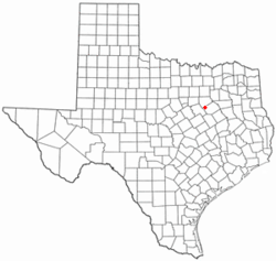
TXMap-doton-Frost.PNG
Location of Frost, Texas
Navarro County Frost.svg
Coordinates: 32°04′44″N96°48′31″W / 32.07889°N 96.80861°W / 32.07889; -96.80861
Country United States
State Texas
County Navarro
Area
[1]
  Total1.13 sq mi (2.94 km2)
  Land1.13 sq mi (2.93 km2)
  Water0.00 sq mi (0.01 km2)
Elevation
[2]
522 ft (159 m)
Population
 (2020)
  Total620
  Density550/sq mi (210/km2)
Time zone UTC-6 (Central (CST))
  Summer (DST) UTC-5 (CDT)
ZIP code
76641
Area code(s) 903, 430
FIPS code 48-27768 [3]
GNIS feature ID2410551 [2]

Frost is a city in Navarro County, Texas, United States. The population was 620 at the 2020 census.

Contents

History

Frost was founded by fifth generation Texan, Miles Frost in 1899 as a trading post for north central Texas farmers.

The town was established in 1881 when the St. Louis Southwestern Railway was constructed through Frost on its way from Corsicana to Hillsboro. It was named after Samuel R. Frost, attorney for the railroad and a prominent local politician. [4]

Geography

According to the United States Census Bureau, the city has a total area of 1.1 square miles (2.8 km2), of which 1.1 square miles (2.8 km2) is land and 0.88% is water.

Demographics

Historical population
CensusPop.Note
1900 621
1910 70213.0%
1920 91330.1%
1930 748−18.1%
1940 671−10.3%
1950 585−12.8%
1960 508−13.2%
1970 5487.9%
1980 5642.9%
1990 5792.7%
2000 64811.9%
2010 643−0.8%
2020 620−3.6%
U.S. Decennial Census [5]
2020 Census [6]

As of 2022 the American Community Survey estimates, there were 740 people and 236 households. [7] [8] The population density was 654.3 inhabitants per square mile (252.6/km2). There were 258 housing units at an average density of 228.1 per square mile (88.1/km2). [9] [8] [10] The racial makeup of the city was 70.1% White, 16.8% some other race, and 4.1% Black or African American, with 9.1% from two or more races. [8] Hispanics or Latinos of any race were 23.9% of the population. [8]

Of the 236 households, 51.3% had children under the age of 18 living with them, 25.0% had seniors 65 years or older living with them, 66.9% were married couples living together, 2.5% were couples cohabitating, 11.0% had a male householder with no partner present, and 19.5% had a female householder with no partner present. [7] The median household size was 3.14 and the median family size was 3.41. [7]

The age distribution was 28.0% under 18, 6.8% from 18 to 24, 23.4% from 25 to 44, 29.1% from 45 to 64, and 12.8% who were 65 or older. The median age was 37.2 years. [11] For every 100 females, there were 94.2 males. [8]

The median income for a household was $78,000, with family households having a median income of $77,500 and non-family households $68,750. The per capita income was $25,312. [12] [13] Males working full-time jobs had median earnings of $65,625 compared to $39,286 for females. [14] Out of the 729 people with a determined poverty status, 10.4% were below the poverty line. Further, 9.7% of minors and 3.2% of seniors were below the poverty line. [15]

In the survey, residents self-identified with various ethnic ancestries. People of American descent made up 7.8% of the population of the town, followed by Irish at 7.7%, English at 7.0%, German at 5.3%, Hungarian at 2.4%, Scotch-Irish at 1.5%, Scottish at 1.4%, Swedish at 1.2%, and French at 0.9%. [7]

Education

The City of Frost is served by the Frost Independent School District.

Climate

The climate in this area is characterized by hot, humid summers and generally mild to cool winters. According to the Köppen Climate Classification system, Frost has a humid subtropical climate, abbreviated "Cfa" on climate maps. [16]

Cultural references

On May 6, 1930, a tornado struck the city, destroying many buildings and leaving 41 dead. The event was commemorated in the song "Frost Texas Tornado Blues" by Texas Alexander and the Mississippi Sheiks, recorded April 9, 1934 in San Antonio, Texas on the Okeh label. [17]

Related Research Articles

<span class="mw-page-title-main">Garnett, Kansas</span> City in Anderson County, Kansas

Garnett is a city in and the county seat of Anderson County, Kansas, United States. As of the 2020 census, the population of the city was 3,242.

<span class="mw-page-title-main">Cedar Vale, Kansas</span> City in Chautauqua County, Kansas

Cedar Vale is a city in Chautauqua County, Kansas, United States. As of the 2020 census, the population of the city was 476.

<span class="mw-page-title-main">Miltonvale, Kansas</span> City in Cloud County, Kansas

Miltonvale is a city in Cloud County, Kansas, United States. As of the 2020 census, the population of the city was 440.

<span class="mw-page-title-main">Belpre, Kansas</span> City in Edwards County, Kansas, United States

Belpre is a city in Edwards County, Kansas, United States. As of the 2020 census, the population of the city was 97. It is located along Highway 50.

<span class="mw-page-title-main">Madison, Kansas</span> City in Greenwood County, Kansas

Madison is a city in Greenwood County, Kansas, United States, along the Verdigris River. As of the 2020 census, the population of the city was 689.

<span class="mw-page-title-main">Circleville, Kansas</span> City in Jackson County, Kansas

Circleville is a city in Jackson County, Kansas, United States. As of the 2020 census, the population of the city was 153.

<span class="mw-page-title-main">Oskaloosa, Kansas</span> City and County seat in Kansas, United States

Oskaloosa is a city in and the county seat of Jefferson County, Kansas, United States. As of the 2020 census, the population of the city was 1,110.

<span class="mw-page-title-main">Chetopa, Kansas</span> City in Labette County, Kansas

Chetopa is a city in Labette County, Kansas, United States. As of the 2020 census, the population of the city was 929. Chetopa was named for Chief Chetopah, an Osage Indian chief. Later, the community name was shortened.

<span class="mw-page-title-main">Mound Valley, Kansas</span> City in Labette County, Kansas

Mound Valley is a city in Labette County, Kansas, United States. As of the 2020 census, the population of the city was 348.

<span class="mw-page-title-main">Ness City, Kansas</span> City in Ness County, Kansas

Ness City is a city in and the county seat of Ness County, Kansas, United States. As of the 2020 census, the population of the city was 1,329. Ness City is famous for its four-story Old Ness County Bank Building located downtown and nicknamed Skyscraper of the Plains.

<span class="mw-page-title-main">Larned, Kansas</span> City in Pawnee County, Kansas

Larned is a city in and the county seat of Pawnee County, Kansas, United States. As of the 2020 census, the population of the city was 3,769.

<span class="mw-page-title-main">McDonald, Kansas</span> City in Rawlins County, Kansas

McDonald is a city in Rawlins County, Kansas, United States. As of the 2020 census, the population of the city was 113.

<span class="mw-page-title-main">Damar, Kansas</span> City in Rooks County, Kansas

Damar is a city in Rooks County, Kansas, United States. As of the 2020 census, the population of the city was 112.

<span class="mw-page-title-main">Oxford, Kansas</span> City in Sumner County, Kansas

Oxford is a city in Sumner County, Kansas, United States. As of the 2020 census, the population of the city was 1,048.

<span class="mw-page-title-main">Barnsdall, Oklahoma</span> City in Osage County

Barnsdall is a city in Osage County, Oklahoma, United States. As of the 2020 census, the population of the city was 1,034.

<span class="mw-page-title-main">Port Carbon, Pennsylvania</span> Borough in Pennsylvania, United States

Port Carbon is a borough of Schuylkill County, Pennsylvania, United States, located two miles (3 km) northeast of Pottsville. It is in a coal-mining area. In the past, ironworks had been a feature of the borough. In 1900, 2,168 people lived here and, in 1910, 2,678. The population was 1,815 at the 2020 census.

<span class="mw-page-title-main">San Saba, Texas</span> City in Texas, United States

San Saba is a city located in, and the county seat of, San Saba County, Texas, United States. It was settled in 1854 and named for its location on the San Saba River and for Sabbas the Sanctified. Its population was 3,099 at the 2010 census.

<span class="mw-page-title-main">Sachse, Texas</span> City in Texas, United States

Sachse is a city in Collin and Dallas counties in the U.S. state of Texas and is part of the DFW metroplex. A northeastern suburb of Dallas, the city population was 27,103, as of the 2020 census with an estimated population of 33,768 people today. Sachse is located off Texas State Highway 78 and President George Bush Turnpike and is approximately 1 mile (1.6 km) north of the Firewheel Town Center.

<span class="mw-page-title-main">Waller, Texas</span> City in Harris and Waller counties in Texas, United States

Waller is a city in Harris and Waller counties in Texas, United States, that is within the Houston–Cypress metropolitan area. Its population was 2,682 at the 2020 U.S. census. The Waller area is located along U.S. Route 290 41 miles (66 km) northwest of downtown Houston.

<span class="mw-page-title-main">Mount Zion, Illinois</span> Village in Illinois, United States

Mount Zion is a village in Macon County, Illinois, United States. The population was 6,019 at the 2020 census.

References

  1. "2019 U.S. Gazetteer Files". United States Census Bureau. Retrieved August 7, 2020.
  2. 1 2 U.S. Geological Survey Geographic Names Information System: Frost, Texas
  3. "American FactFinder". United States Census Bureau. Archived from the original on February 12, 2020. Retrieved January 31, 2008.
  4. Love, Annie Carpenter (1933). History of Navarro County.
  5. "Census of Population and Housing". Census.gov. Archived from the original on April 26, 2015. Retrieved June 4, 2015.
  6. "Census Bureau profile: Frost, Texas". United States Census Bureau. May 2023. Retrieved May 23, 2024.
  7. 1 2 3 4 "2022 American Community Survey 5 Year Estimate: Selected Social Characteristics in the United States for Frost city, TX". United States Census Bureau . Retrieved June 22, 2024.
  8. 1 2 3 4 5 "2022 American Community Survey 5 Year Estimate: Demographic and Housing Estimates for Frost city, TX". United States Census Bureau . Retrieved June 22, 2024.
  9. "2022 American Community Survey 5 Year Estimate: Housing Units for Frost city, TX". United States Census Bureau . Retrieved June 22, 2024.
  10. To calculate density we use the land area figure from the places file in "The 2023 U.S. Gazetteer Files".
  11. "2022 American Community Survey 5 Year Estimate: Age and Sex for Frost city, TX". United States Census Bureau . Retrieved June 22, 2024.
  12. "2022 American Community Survey 5 Year Estimate: Mean Income in the Past 12 Months (in 2022 Inflation-Adjusted Dollars) for Frost city, TX". United States Census Bureau . Retrieved June 22, 2024.
  13. "2022 American Community Survey 5 Year Estimate: Income in the Past 12 Months (in 2022 Inflation-Adjusted Dollars) for Frost city, TX". United States Census Bureau . Retrieved June 22, 2024.
  14. "2022 American Community Survey 5 Year Estimate: Earnings in the Past 12 Months (in 2022 Inflation-Adjusted Dollars) for Frost city, TX". United States Census Bureau . Retrieved June 22, 2024.
  15. "2022 American Community Survey 5 Year Estimate: Poverty Status in the Past 12 Months for Frost city, TX". United States Census Bureau . Retrieved June 22, 2024.
  16. "Frost, Texas Koppen Climate Classification (Weatherbase)". Weatherbase.com. Retrieved November 4, 2023.
  17. "Big Road Blues Show 8/1/10: Sitting On Top Of The World – Mississippi Sheiks & Associates". August 1, 2010. Retrieved June 27, 2015.