Hillsboro is a city in and the county seat of Hill County, Texas, United States. As of the 2020 census, Hillsboro had a population of 8,221.[5] It is located between Dallas, Fort Worth and Waco, directly on Interstate 35 in North Central Texas. Hillsboro draws trade from throughout the county, and from Interstate 35 travelers between Dallas, Fort Worth, and Waco.
Hillsboro is the gateway to Lake Whitney, Lake Whitney State Park, and nearby Lake Aquilla - all within a 15 minute drive from Hillsboro, Texas.
History
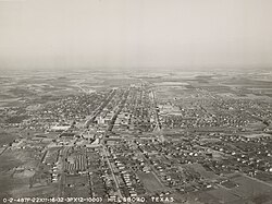
Hillsboro in 1932
In 1853, the Texas Legislature carved Hill County out of Navarro County. Named for physician and Republic of Texas Secretary of War Dr. George Washington Hill, the new county had only recently attracted Anglo settlement, following the establishment in 1848 of Fort Graham. County commissioners selected Hillsboro, originally spelled Hillsborough, as county seat.[6] They established the town on land donated by Thomas Steiner, John Caruthers and Jonathan Newby, and the community soon had a school and post office, as well as a wood-frame courthouse. Cotton became the mainstay of Hillsboro’s late 19th-century economy.[7] The city experienced rapid growth after the Missouri, Kansas & Texas Railroad and other lines came to the town in the early 1880s. In addition to bringing new settlers and giving access to shipping and transportation, railroads provided many new jobs.[8] The city continued to grow and incorporated in 1881. The cotton industry produced a building boom between 1890 and 1910, as evidenced by the numerous Queen Anne homes still intact today, as well as the noted 1890 Hill County Courthouse. In 1923, the community established the Hillsboro Junior College, which over the years has become Hill College.
Hill College, located in Hillsboro, provides educational programs to enrolled students, the community, local workforce and area businesses and adult learners.
Hillsboro has private Christian academies and home school groups, in addition to the school district and college.
Hillsboro is a rural city located directly on Interstate 35 between Dallas-Fort Worth and Waco.
Hillsboro's location offers residents and business significant advantages, and as the seat of Hill County attracts trade from a 30+ mile radius of county cities, and a significant portion Interstate travelers. With an active and close knit community, Hillsboro's culture includes numerous events and programs continuously through the year for both residents and visitors.
Large annual events in Hillsboro include:
January - Hill County Fair/Livestock Show
February - Fire & Ice Dinner at the Rusted Chandelier
March - Hill College Rodeo
April - Starlight Bar Night in downtown Hillsboro
May - Churrofest Annual Festival with Concerts & Margarita Walk
May to October - The Hillsboro Farmers Market at the Courthouse Square
May, June, Sept, Oct - Free Saturday Night Summer Concert Series, Weekly from 8 to 11 pm
June - The Bond's Alley Art Festival
July - 4th of July Late Bloomers Parade in the Historic Residential District
October - Autumnfest Annual Festival
December - Christmas Under the Stars Parade & Tree Lighting
Geography
Hillsboro is located near the geographic center of Hill County. Interstate 35 passes through the eastern side of the city, with access from Exits 364 through 370. The I-35E/I-35W split is just north of the city limits. Hillsboro is 56 miles (90km) south of Fort Worth, 62 miles (100km) southwest of Dallas, and 34 miles (55km) north of Waco.
Texas State Highway 22 runs through the center of Hillsboro on West Elm Street, South Waco Street, and Corsicana Highway. It leads west 19 miles (31km) to Lake Whitney and east 40 miles (64km) to Corsicana. Texas State Highway 171 passes through Hillsboro with Highway 22, but leads northwest 29 miles (47km) to Cleburne and southeast 23 miles (37km) to Hubbard.
Climate
Climate data for Hillsboro, Texas (1991–2020 normals, extremes 1903–present)
As of the 2020 United States census, there were 8,221 people, 2,925 households, and 2,024 families residing in the boundaries of Hillsboro Texas, however the population is thought to be far greater than the census numbers for the city reflect.
↑Head, James. "Maggie Jones". TSHA Online. Retrieved January 25, 2010.
↑Note: the US Census treats Hispanic/Latino as an ethnic category. This table excludes Latinos from the racial categories and assigns them to a separate category. Hispanics/Latinos can be of any race.[13][14]
This page is based on this Wikipedia article Text is available under the CC BY-SA 4.0 license; additional terms may apply. Images, videos and audio are available under their respective licenses.