Haskell, Texas | |
---|---|
Coordinates: 33°9′37″N99°44′4″W / 33.16028°N 99.73444°W | |
Country | United States |
State | Texas |
County | Haskell |
Area | |
• Total | 3.60 sq mi (9.32 km2) |
• Land | 3.60 sq mi (9.32 km2) |
• Water | 0.00 sq mi (0.00 km2) |
Elevation | 1,581 ft (482 m) |
Population (2010) | |
• Total | 3,322 |
• Estimate (2019) [2] | 3,153 |
• Density | 876.32/sq mi (338.38/km2) |
Time zone | UTC-6 (Central (CST)) |
• Summer (DST) | UTC-5 (CDT) |
ZIP code | 79521 |
Area code | 940 |
FIPS code | 48-32696 [3] |
GNIS feature ID | 1358889 [4] |
Website | haskelltexasusa |
Haskell is a city in central Haskell County, Texas, United States. As of the 2010 census, the city population was 3,322. [5] It is the Haskell county seat. [6]
Haskell was once the site of a watering place known as Willow Pond Springs. Thomas F. Tucker settled the site in 1879 upon the encouragement of his brother, a member of Randolph B. Marcy's 1849 expedition, and named it Rice Springs. When Haskell County was organized in 1885, the town became the county seat, and Tucker became the first county judge. The town was renamed to Haskell the same year. [7]
In 1906, the Texas Central Railroad reached Haskell from Stamford. Haskell was subsequently incorporated in 1907. [7]
Haskell is located at 33°9′37″N99°44′4″W / 33.16028°N 99.73444°W (33.160152, –99.734572). [8] U.S. Route 277 passes through the eastern side of the city, leading northeast 98 miles (158 km) to Wichita Falls and south 54 miles (87 km) to Abilene. U.S. Route 380 runs through the center of Haskell as North 1st Street, leading east 162 miles (261 km) to Denton and west 107 miles (172 km) to Post. Lubbock is 147 miles (237 km) northwest of Haskell via US 380 and US 84.
According to the United States Census Bureau, the city has a total area of 3.6 square miles (9.3 km2), all land. [5]
The Haskell County Courthouse was completed in 1892 and was designed and built by A.O. Watson. The east and west wings were added in 1930–1931. It is one of the oldest courthouses still in use in the area. [9]
Haskell is the county seat of Haskell County.
Census | Pop. | Note | %± |
---|---|---|---|
1890 | 745 | — | |
1910 | 2,436 | — | |
1920 | 2,300 | −5.6% | |
1930 | 2,632 | 14.4% | |
1940 | 3,051 | 15.9% | |
1950 | 3,836 | 25.7% | |
1960 | 4,016 | 4.7% | |
1970 | 3,655 | −9.0% | |
1980 | 3,782 | 3.5% | |
1990 | 3,362 | −11.1% | |
2000 | 3,106 | −7.6% | |
2010 | 3,322 | 7.0% | |
2019 (est.) | 3,153 | [2] | −5.1% |
U.S. Decennial Census [10] |
Race | Number | Percentage |
---|---|---|
White (NH) | 1,904 | 61.64% |
Black or African American (NH) | 154 | 4.99% |
Native American or Alaska Native (NH) | 10 | 0.32% |
Asian (NH) | 21 | 0.68% |
Pacific Islander (NH) | 2 | 0.06% |
Some Other Race (NH) | 13 | 0.42% |
Mixed/Multi-Racial (NH) | 70 | 2.27% |
Hispanic or Latino | 915 | 29.62% |
Total | 3,089 |
As of the 2020 United States census, there were 3,089 people, 1,043 households, and 730 families residing in the city.
At the 2010 census, there were 3,322 people, an increase of 6.95% since 2000 (216 people). The racial makeup of the town was 80.40% White (2,671 people), 4.94% African American (164 people), 0.75% Native American (25 people), 0.75% Asian (25 people), 10.69% from other races (355 people), and 2.47% from two or more races (82 people). Hispanic or Latino of any race were 26.76% of the population (889 people).
At the 2000 census there were 3,106 people, 1,295 households, and 868 families living in the city. The population density was 912.8 inhabitants per square mile (352.4/km2). There were 1,526 housing units at an average density of 448.5 per square mile (173.2/km2). The racial makeup of the city was 80.33% White, 3.90% African American, 0.55% Native American, 0.10% Asian, 12.46% from other races, and 2.67% from two or more races. Hispanic or Latino of any race were 22.70%. [3]
Of the 1,295 households 29.7% had children under the age of 18 living with them, 53.8% were married couples living together, 10.1% had a female householder with no husband present, and 32.9% were non-families. 31.3% of households were one person and 20.5% were one person aged 65 or older. The average household size was 2.32 and the average family size was 2.91.
The age distribution was 25.2% under the age of 18, 5.7% from 18 to 24, 22.5% from 25 to 44, 20.6% from 45 to 64, and 25.9% 65 or older. The median age was 42 years. For every 100 females, there were 83.5 males. For every 100 females age 18 and over, there were 80.7 male.
The median household income was $20,740 and the median family income was $27,109. Males had a median income of $20,245 versus $15,391 for females. The per capita income for the city was $13,114. About 21.5% of families and 28.7% of the population were below the poverty line, including 42.4% of those under age 18 and 18.1% of those age 65 or over.
The City of Haskell is served by the Haskell Consolidated Independent School District.
The climate in this area is characterized by hot, humid summers and generally mild to cool winters. According to the Köppen Climate Classification system, Haskell has a humid subtropical climate, abbreviated "Cfa" on climate maps. [14]
Climate data for Haskell, Texas (1991–2020 normals, extremes 1893–present) | |||||||||||||
---|---|---|---|---|---|---|---|---|---|---|---|---|---|
Month | Jan | Feb | Mar | Apr | May | Jun | Jul | Aug | Sep | Oct | Nov | Dec | Year |
Record high °F (°C) | 89 (32) | 94 (34) | 101 (38) | 107 (42) | 112 (44) | 115 (46) | 115 (46) | 115 (46) | 109 (43) | 105 (41) | 91 (33) | 89 (32) | 115 (46) |
Mean daily maximum °F (°C) | 55.6 (13.1) | 59.1 (15.1) | 67.9 (19.9) | 77.1 (25.1) | 84.8 (29.3) | 91.7 (33.2) | 95.4 (35.2) | 94.5 (34.7) | 87.1 (30.6) | 77.2 (25.1) | 65.0 (18.3) | 55.7 (13.2) | 75.9 (24.4) |
Daily mean °F (°C) | 42.2 (5.7) | 45.7 (7.6) | 54.2 (12.3) | 63.0 (17.2) | 72.0 (22.2) | 79.8 (26.6) | 83.4 (28.6) | 82.5 (28.1) | 74.9 (23.8) | 64.0 (17.8) | 52.3 (11.3) | 43.4 (6.3) | 63.1 (17.3) |
Mean daily minimum °F (°C) | 28.9 (−1.7) | 32.3 (0.2) | 40.4 (4.7) | 48.8 (9.3) | 59.2 (15.1) | 68.0 (20.0) | 71.5 (21.9) | 70.5 (21.4) | 62.7 (17.1) | 50.8 (10.4) | 39.5 (4.2) | 31.1 (−0.5) | 50.3 (10.2) |
Record low °F (°C) | −3 (−19) | −6 (−21) | 5 (−15) | 24 (−4) | 34 (1) | 46 (8) | 54 (12) | 49 (9) | 36 (2) | 18 (−8) | 9 (−13) | −6 (−21) | −6 (−21) |
Average precipitation inches (mm) | 1.19 (30) | 1.49 (38) | 1.98 (50) | 2.07 (53) | 3.35 (85) | 3.78 (96) | 1.80 (46) | 2.52 (64) | 3.25 (83) | 2.53 (64) | 1.74 (44) | 1.25 (32) | 26.95 (685) |
Average snowfall inches (cm) | 0.4 (1.0) | 1.4 (3.6) | 0.0 (0.0) | 0.0 (0.0) | 0.0 (0.0) | 0.0 (0.0) | 0.0 (0.0) | 0.0 (0.0) | 0.0 (0.0) | 0.0 (0.0) | 0.5 (1.3) | 0.8 (2.0) | 3.1 (7.9) |
Average precipitation days (≥ 0.01 in) | 4.5 | 5.3 | 5.6 | 4.7 | 7.4 | 7.0 | 4.5 | 5.5 | 5.6 | 5.8 | 4.6 | 4.6 | 65.1 |
Average snowy days (≥ 0.1 in) | 0.3 | 0.5 | 0.0 | 0.0 | 0.0 | 0.0 | 0.0 | 0.0 | 0.0 | 0.0 | 0.2 | 0.6 | 1.6 |
Source: NOAA [15] [16] |
Parmer County is a county located in the southwestern Texas Panhandle on the High Plains of the Llano Estacado in the U.S. state of Texas. As of the 2020 Census, the population was 9,869. The county seat is Farwell. The county was created in 1876 and later organized in 1907. It is named in honor of Martin Parmer, a signer of the Texas Declaration of Independence and early judge. Parmer County was one of 10 prohibition, or entirely dry, counties in the state of Texas, but is now a wet county.
Haskell County is a county located in the U.S. state of Texas. As of the 2020 census, its population was 5,416. The county seat is Haskell. The county was created in 1858 and later organized in 1885. It is named for Charles Ready Haskell, who was killed in the Goliad massacre.
Blanco is a city in rural Blanco County, Texas, United States. The population was 1,739 at the 2010 census. Blanco is a cattle and ranching community.
Meridian is a city and the county seat of Bosque County in central Texas, United States. It is forty-seven miles northwest of Waco. The population was 1,493 at the 2010 census.
Caldwell is a city in and the county seat of Burleson County, Texas, United States. The population was 3,993 at the 2020 census. It is part of the Bryan-College Station metropolitan area.
Baird is a city and the county seat of Callahan County, Texas, United States. Its population was 1,496 at the 2010 census. The city is named after Matthew Baird, the owner and director of the Texas and Pacific Railway. The railway depot is now operated as the visitor center and a transportation museum.
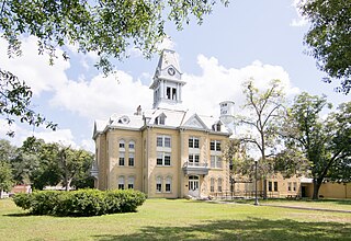
Comanche is a city located in Comanche County in the U.S. state of Texas. The population was 4,335 at the 2010 census. It is the county seat of Comanche County.
Paducah is a town in Cottle County, Texas, United States. The population was 1,186 at the 2010 census, down from 1,498 in 2000. It is the county seat of Cottle County. It is just south of the Texas Panhandle and east of the Llano Estacado.
Lamesa is a city in and the county seat of Dawson County, Texas, United States. The population was 8,674 at the 2020 census, down from 9,952 at the 2000 census. Located south of Lubbock on the Llano Estacado, Lamesa was founded in 1903. Most of its economy is based on cotton farming. The Preston E. Smith prison unit, named for the former governor of Texas, is located just outside Lamesa.
Dickens is a city in and the county seat of Dickens County, Texas, United States. The population was 286 at the 2010 census, down from 332 at the 2000 census.
Eastland is a city in Eastland County, Texas, United States. Its population was 3,960 at the 2010 census. It is the county seat of Eastland County.
Pearsall is a city in and the county seat of Frio County, Texas, United States. The population was 9,146 at the 2010 census, up from 7,157 at the 2000 census.
Hamilton is a city in and the county seat of Hamilton County, Texas, United States, located in the state's central region. Its population was 3,096 at the 2010 census.
Rule is a town in Haskell County, Texas, United States. The population was 636 at the 2010 census, down from 698 at the 2000 census.
Stinnett is a city in and the county seat of Hutchinson County, Texas, United States. The population was 1,881 at the 2010 census, a decrease from 1,936 at the 2000 census.
Benjamin is a city in and the county seat of Knox County, Texas, United States. Its population was 258 at the 2010 census.
Centerville is a city in Leon County, in the U.S. state of Texas. The population was 905 at the 2020 census. It is the county seat of Leon County. Centerville was so named as it is near the geographic center of Leon County.
Newton is a city in and the county seat of Newton County, Texas, United States. The population was 1,633 at the 2020 census.
Mount Pleasant is the county seat of and largest city in Titus County, in the U.S. state of Texas. As of the 2020 census, Mount Pleasant's population was 16,047; it is situated in Northeast Texas.
Wheeler is a city, and the county seat of Wheeler County, Texas, United States, located on the eastern border of the Texas Panhandle. The population was last reported at 1,592 in the 2010 census.