Jayton, Texas

Last updated

Jayton, Texas
Jayton, Texas
Jayton, Texas in August 2012.jpg
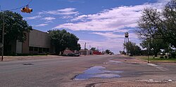
Jayton's water tower and the Kent County Court in 2012
Motto: 
"Where pride makes the difference!”
TXMap-doton-Jayton.PNG
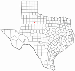
Location of Jayton, Texas
Kent County Jayton.svg
Coordinates: 33°15′00″N100°34′28″W / 33.25000°N 100.57444°W / 33.25000; -100.57444
Country United States
State Texas
County Kent
Area
[1]
  Total1.70 sq mi (4.39 km2)
  Land1.70 sq mi (4.39 km2)
  Water0.00 sq mi (0.00 km2)
Elevation
[2]
2,001 ft (610 m)
Population
 (2020)
  Total511
  Density295.82/sq mi (114.23/km2)
Time zone UTC-6 (Central (CST))
  Summer (DST) UTC-5 (CDT)
ZIP code
79528
Area code 806
FIPS code 48-37468 [3]
GNIS feature ID2410136 [2]

Jayton is a city in and the county seat of Kent County, Texas, United States. [4] It is located in the northeastern portion of the county, and the population was 511 as of the 2020 census.

Contents

History

Jayton's history begins in the 1880s. Originally known as "Jay Flat", it was established 2 miles (3 km) northeast of its present location and named after a local ranching family. A post office was granted in 1886, and Daniel Jay served as the community's first postmaster. In 1907, the townsite was moved to its present location for improved proximity to rail service, and it was officially renamed "Jayton" later that same year. The community's first newspaper, the Jayton Herald, was established the following year, and the city incorporated in February 1910. By 1925, Jayton was home to 750 residents.

From the community's inception, the local economy had originally been supported mainly by the cotton industry, but the Dust Bowl of the 1930s had a dire effect on production. The community's economy was stabilized by the discovery of oil later that same decade, and while its population never exceeded 750, Jayton remained stable throughout the Great Depression. In 1954, following a lengthy and heated court battle, the city wrested the title of county seat from the declining nearby community of Clairemont, and in 1957, a courthouse was constructed. Jayton's population remained around 600 from the 1950s through the 1980 census before declining to 513 in 1990 and 441 in 2000, but a resurgence in the local oil industry led to a rebound, and the 2010 census counted 534 residents.

Geography

Jayton is located in eastern Kent County. U.S. Route 380 touches the southern border of the city; the highway leads southeast 24 miles (39 km) to Aspermont and southwest 13 miles (21 km) to Clairemont. Texas State Highway 70 is Jayton's Main Street and leads northwest 24 miles (39 km) to Spur. The closest large cities are Lubbock, 93 miles (150 km) to the northwest, and Abilene, 84 miles (135 km) to the southeast.

According to the United States Census Bureau, Jayton has a total area of 1.7 square miles (4.4 km2), all land. [5]

Kent County Airport is south of the city. The airport has one asphalt runway 3,300 feet (1,000 m) in length. The nearest airport with commercial service is approximately 100 miles away, in Lubbock.

Climate

According to the Köppen climate classification system, Jayton has a semiarid climate, BSk on climate maps. [6]

Climate data for Jayton, Texas (1991–2020 normals, extremes 1962–present)
MonthJanFebMarAprMayJunJulAugSepOctNovDecYear
Record high °F (°C)87
(31)
93
(34)
99
(37)
108
(42)
111
(44)
116
(47)
114
(46)
112
(44)
110
(43)
105
(41)
91
(33)
86
(30)
116
(47)
Mean maximum °F (°C)77.6
(25.3)
81.8
(27.7)
89.0
(31.7)
94.6
(34.8)
99.9
(37.7)
102.8
(39.3)
104.2
(40.1)
103.7
(39.8)
99.1
(37.3)
93.6
(34.2)
84.2
(29.0)
77.7
(25.4)
106.6
(41.4)
Mean daily maximum °F (°C)56.6
(13.7)
60.7
(15.9)
69.1
(20.6)
78.1
(25.6)
85.6
(29.8)
92.9
(33.8)
96.5
(35.8)
95.8
(35.4)
87.8
(31.0)
78.3
(25.7)
66.2
(19.0)
57.2
(14.0)
77.1
(25.1)
Daily mean °F (°C)42.2
(5.7)
45.9
(7.7)
54.2
(12.3)
62.7
(17.1)
71.7
(22.1)
79.9
(26.6)
83.6
(28.7)
82.7
(28.2)
74.8
(23.8)
64.0
(17.8)
52.1
(11.2)
43.2
(6.2)
63.1
(17.3)
Mean daily minimum °F (°C)27.9
(−2.3)
31.1
(−0.5)
39.2
(4.0)
47.3
(8.5)
57.8
(14.3)
66.9
(19.4)
70.7
(21.5)
69.6
(20.9)
61.8
(16.6)
49.8
(9.9)
38.0
(3.3)
29.2
(−1.6)
49.1
(9.5)
Mean minimum °F (°C)14.2
(−9.9)
16.9
(−8.4)
22.5
(−5.3)
31.5
(−0.3)
42.3
(5.7)
57.4
(14.1)
63.1
(17.3)
62.2
(16.8)
48.0
(8.9)
32.8
(0.4)
21.7
(−5.7)
15.2
(−9.3)
10.2
(−12.1)
Record low °F (°C)−2
(−19)
−6
(−21)
6
(−14)
24
(−4)
31
(−1)
44
(7)
54
(12)
54
(12)
34
(1)
16
(−9)
10
(−12)
−5
(−21)
−6
(−21)
Average precipitation inches (mm)0.87
(22)
1.12
(28)
1.38
(35)
1.77
(45)
3.12
(79)
3.28
(83)
2.46
(62)
2.13
(54)
2.63
(67)
2.12
(54)
1.42
(36)
0.98
(25)
23.28
(591)
Average snowfall inches (cm)0.7
(1.8)
1.9
(4.8)
0.1
(0.25)
0.0
(0.0)
0.0
(0.0)
0.0
(0.0)
0.0
(0.0)
0.0
(0.0)
0.0
(0.0)
0.0
(0.0)
0.8
(2.0)
0.6
(1.5)
4.1
(10)
Average precipitation days (≥ 0.01 in)2.23.13.23.14.95.14.03.74.33.52.42.341.8
Average snowy days (≥ 0.1 in)0.40.60.10.00.00.00.00.00.00.10.30.41.9
Source: NOAA [7] [8]

Demographics

Historical population
CensusPop.Note
1910 314
1930 623
1940 77023.6%
1950 635−17.5%
1960 6492.2%
1970 7038.3%
1980 638−9.2%
1990 608−4.7%
2000 513−15.6%
2010 5344.1%
2020 511−4.3%
U.S. Decennial Census [9]

2020 census

Note: the US Census treats Hispanic/Latino as an ethnic category. This table excludes Latinos from the racial categories and assigns them to a separate category. Hispanics/Latinos can be of any race. [10] [11]

Jayton racial composition [12]
(NH = Non-Hispanic)
RaceNumberPercentage
White (NH)43785.52%
Black or African American (NH)20.39%
Native American or Alaska Native (NH)30.59%
Some Other Race (NH)30.59%
Mixed/Multi-Racial (NH)50.98%
Hispanic or Latino 6111.94%
Total511

As of the 2020 United States census, there were 511 people, 207 households, and 108 families residing in the city.

2000 census

As of the census [3] of 2000, 513 people, 209 households, and 144 families resided in the city. The population density was 301.6 inhabitants per square mile (116.4/km2). The 277 housing units averaged 162.9/sq mi (62.9/km2). The racial makeup of the city was 96.69% White, 0.19% African American, 0.39% Native American, 2.53% from other races, and 0.19% from two or more races. Hispanics or Latinos of any race were 10.92% of the population.

Of the 209 households, 25.8% had children under the age of 18 living with them, 59.3% were married couples living together, 6.2% had a female householder with no husband present, and 31.1% were not families. About 29.2% of all households were made up of individuals, and 15.8% had someone living alone who was 65 years of age or older. The average household size was 2.27 and the average family size was 2.81.

In the city, the population was distributed as 19.7% under the age of 18, 4.9% from 18 to 24, 20.7% from 25 to 44, 27.9% from 45 to 64, and 26.9% who were 65 years of age or older. The median age was 50 years. For every 100 females, there were 84.5 males. For every 100 females age 18 and over, there were 83.1 males.

The median income for a household in the city was $32,396, and for a family was $39,375. Males had a median income of $25,000 versus $21,875 for females. The per capita income for the city was $17,314. About 9.6% of families and 8.8% of the population were below the poverty line, including 5.5% of those under age 18 and 1.0% of those age 65 or over.

Education

The city is served by the Jayton-Girard Independent School District, and the local high school is Jayton High School.

Notable people

Related Research Articles

<span class="mw-page-title-main">Kent County, Texas</span> County in Texas, United States

Kent County is a county located in the U.S. state of Texas. As of the 2020 census, its population was 753, making it the sixth-least populous county in Texas. Its county seat is Jayton. The county was created in 1876 and later organized in 1892. It is named for Andrew Kent, who died at the Battle of the Alamo. Kent County is a prohibition or entirely dry county, one of four remaining in the state.

<span class="mw-page-title-main">Jourdanton, Texas</span> City in Texas, United States

Jourdanton is a city in and the county seat of Atascosa County, Texas, United States. The population is 4,094. It is part of the San Antonio metropolitan statistical area. The mayor is Robert "Doc" Williams. The city manager is Bobby J. Martinez. The police chief is Eric Kaiser. The fire chief is Jay Fojtik.

<span class="mw-page-title-main">Paducah, Texas</span> Town in Cottle County, Texas, United States

Paducah is a town in Cottle County, Texas, United States. The population was 1,063 at the 2020 census, down from 1,186 in 2010. It is the county seat of Cottle County. It is just south of the Texas Panhandle and east of the Llano Estacado.

<span class="mw-page-title-main">Crosbyton, Texas</span> City in Texas, United States

Crosbyton is a city in and the county seat of Crosby County, Texas, United States. The population was 1,492 at the 2020 census. Crosbyton is part of the Lubbock Metropolitan Statistical Area.

<span class="mw-page-title-main">Lorenzo, Texas</span> City in Texas, United States

Lorenzo is a city in Crosby County, Texas, United States. As of the 2020 census, the city population was 964, down from 1,147 in 2010. It is part of the Lubbock Metropolitan Statistical Area.

<span class="mw-page-title-main">Lamesa, Texas</span> City in Texas, United States

Lamesa is a city in and the county seat of Dawson County, Texas, United States. The population was 8,674 at the 2020 census, down from 9,952 at the 2000 census. Located south of Lubbock on the Llano Estacado, Lamesa was founded in 1903. Most of its economy is based on cotton farming. The Preston E. Smith prison unit, named for the former governor of Texas, is located just outside Lamesa.

<span class="mw-page-title-main">Dickens, Texas</span> City in Texas, United States

Dickens is a city in and the county seat of Dickens County, Texas, United States. The population was 219 at the 2020 census, down from 286 at the 2010 census.

<span class="mw-page-title-main">Rotan, Texas</span> City in Texas, United States

Rotan is a city in Fisher County, Texas, United States. The population was 1,332 at the 2020 census, down from 1,508 at the 2010 census.

<span class="mw-page-title-main">Fairfield, Texas</span> City in Texas, United States

Fairfield is a city and county seat of Freestone County, Texas, United States. The population was 2,850 at the 2020 census, down from 3,094 at the 2000 census. It was founded in 1851.

<span class="mw-page-title-main">Hale Center, Texas</span> City in Texas, United States

Hale Center is a city in Hale County, Texas. The population was 2,062 at the 2020 census, down from 2,252 in 2010.

<span class="mw-page-title-main">Haskell, Texas</span> City in Texas, United States

Haskell is a city in central Haskell County, Texas, United States. As of the 2020 census, the city population was 3,089. It is the Haskell county seat.

<span class="mw-page-title-main">Malakoff, Texas</span> City in Texas, United States

Malakoff is a city in Henderson County, Texas, United States. The population was 2,179 at the 2020 census. The city is named after a Russian fort of Malakoff, which played a pivotal role during the siege of Sevastopol during the Crimean War.

<span class="mw-page-title-main">Levelland, Texas</span> City in Texas, United States

Levelland is a city and the county seat of Hockley County, Texas, United States. As of the 2020 census, the city population was 12,652, down from 13,542 at the 2010 census. It is located on the Llano Estacado, 30 miles (48 km) west of Lubbock. Major industries include cotton farming and petroleum production. It is the home of South Plains College. Levelland is the principal city of the Levelland micropolitan statistical area, which includes all of Hockley County and part of the larger Lubbock–Levelland combined statistical area. Levelland was so named on account of the flat land at the town site.

New Deal is a U.S. town in Lubbock County, Texas. The population was 730 at the 2020 census. It is part of the Lubbock Metropolitan Statistical Area and the Llano Estacado region.

<span class="mw-page-title-main">Shallowater, Texas</span> City in Texas, United States

Shallowater is a city in Lubbock County, Texas, United States. Shallowater is on U.S. Route 84 and the Burlington Northern Santa Fe line, 12 miles (19 km) northwest of Lubbock. Its population was 2,964 at the 2020 census. It is part of the Lubbock metropolitan statistical area.

<span class="mw-page-title-main">Slaton, Texas</span> City in Texas, United States

Slaton is a city in Lubbock County, Texas, United States. Founded by German immigrants, Slaton was the westernmost German settlement in Texas. The population was 5,858 at the 2020 census. Slaton is part of the Lubbock Metropolitan Statistical Area.

<span class="mw-page-title-main">Wolfforth, Texas</span> City in Texas, United States

Wolfforth is a town located in Lubbock County, Texas, United States. It is a southwestern suburb of Lubbock. The population was 5,521 at the 2020 census.

<span class="mw-page-title-main">Tahoka, Texas</span> City in Texas, United States

Tahoka is a city in and the county seat of Lynn County, Texas, United States. The population was 2,375 at the 2020 census.

Cactus is a city in Moore County, Texas, United States, located along U.S. Route 287. The population was 3,057 at the 2020 census.

<span class="mw-page-title-main">Winnsboro, Texas</span> City in Texas, United States

Winnsboro is a city in Franklin and Wood counties in northeastern Texas, United States, north of Tyler. The population was 3,455 at the 2020 census. Settlement of Winnsboro began in the 1850s with a post office established between 1854 and 1855.

References

  1. "2019 U.S. Gazetteer Files". United States Census Bureau. Retrieved August 7, 2020.
  2. 1 2 U.S. Geological Survey Geographic Names Information System: Jayton, Texas
  3. 1 2 "U.S. Census website". United States Census Bureau . Retrieved January 31, 2008.
  4. "Find a County". National Association of Counties. Archived from the original on May 31, 2011. Retrieved June 7, 2011.
  5. "Geographic Identifiers: 2010 Census Summary File 1 (G001), Jayton city, Texas". American FactFinder. U.S. Census Bureau. Archived from the original on February 13, 2020. Retrieved May 8, 2019.
  6. Climate Summary for Jayton, Texas
  7. "NOWData – NOAA Online Weather Data". National Oceanic and Atmospheric Administration. Retrieved December 25, 2023.
  8. "Summary of Monthly Normals 1991–2020". National Oceanic and Atmospheric Administration. Retrieved December 25, 2023.
  9. "Census of Population and Housing". Census.gov. Retrieved June 4, 2015.
  10. https://www.census.gov/ [ not specific enough to verify ]
  11. "About the Hispanic Population and its Origin". www.census.gov. Retrieved May 18, 2022.
  12. "Explore Census Data". data.census.gov. Retrieved May 18, 2022.