Paducah, Texas

Last updated

Paducah, Texas
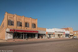
Paducahdowntown1 (1 of 1).jpg
Downtown Paducah, Texas
Motto: 
"Crossroads of America"
TXMap-doton-Paducah.PNG
Location of Paducah, Texas
Cottle County Paducah.svg
Coordinates: 34°0′50″N100°18′14″W / 34.01389°N 100.30389°W / 34.01389; -100.30389
CountryUnited States
State Texas
County Cottle
Area
[1]
  Total1.51 sq mi (3.91 km2)
  Land1.51 sq mi (3.90 km2)
  Water0.00 sq mi (0.01 km2)
Elevation
1,860 ft (567 m)
Population
 (2010)
  Total1,186
  Estimate 
(2019) [2]
1,094
  Density726.43/sq mi (280.50/km2)
Time zone UTC−6 (Central (CST))
  Summer (DST) UTC−5 (CDT)
ZIP code
79248
Area code 806
FIPS code 48-54600 [3]
GNIS feature ID1364686 [4]

Paducah is a town in Cottle County, Texas, United States. The population was 1,186 at the 2010 census, [5] down from 1,498 in 2000. It is the county seat of Cottle County. [6] It is just south of the Texas Panhandle and east of the Llano Estacado.

Contents

History

The town was named for Paducah, a city in western Kentucky. Richard Potts, a settler from Paducah, Kentucky, offered land to new residents in exchange for voting to name the town Paducah and make it the county seat. Paducah officially became the county seat in 1892 and was incorporated in 1910. [7]

Geography

Paducah is located south of the center of Cottle County. According to the United States Census Bureau, the town has a total area of 1.5 square miles (3.9 km2), all land. [5]

Three U.S. highways intersect in the center of town. U.S. Route 83 leads north 32 miles (51 km) to Childress and south 28 miles (45 km) to Guthrie, while U.S. Route 70 leads east 36 miles (58 km) to Crowell and west 31 miles (50 km) to Matador. U.S. Route 62 follows US 83 north out of town and US 70 to the west.

Climate

The Köppen climate classification subtype for this climate is BSk (subtropical steppe climate). [8]

Climate data for Paducah, Texas, 1991–2020 normals, extremes 1954–present
MonthJanFebMarAprMayJunJulAugSepOctNovDecYear
Record high °F (°C)87
(31)
96
(36)
102
(39)
110
(43)
112
(44)
118
(48)
115
(46)
113
(45)
111
(44)
105
(41)
94
(34)
89
(32)
118
(48)
Mean maximum °F (°C)78.6
(25.9)
82.7
(28.2)
89.7
(32.1)
96.0
(35.6)
99.6
(37.6)
104.8
(40.4)
106.4
(41.3)
105.7
(40.9)
101.5
(38.6)
98.3
(36.8)
84.5
(29.2)
78.5
(25.8)
109.2
(42.9)
Average high °F (°C)55.1
(12.8)
58.8
(14.9)
67.6
(19.8)
76.5
(24.7)
84.5
(29.2)
92.9
(33.8)
97.2
(36.2)
96.1
(35.6)
87.6
(30.9)
77.4
(25.2)
65.3
(18.5)
55.3
(12.9)
76.2
(24.5)
Daily mean °F (°C)41.2
(5.1)
44.8
(7.1)
53.2
(11.8)
61.7
(16.5)
70.8
(21.6)
79.5
(26.4)
83.6
(28.7)
82.5
(28.1)
74.3
(23.5)
63.3
(17.4)
51.4
(10.8)
42.0
(5.6)
62.4
(16.9)
Average low °F (°C)27.4
(−2.6)
30.9
(−0.6)
38.8
(3.8)
46.9
(8.3)
57.1
(13.9)
66.1
(18.9)
70.0
(21.1)
68.6
(20.3)
61.1
(16.2)
49.2
(9.6)
37.6
(3.1)
28.7
(−1.8)
48.5
(9.2)
Mean minimum °F (°C)15.1
(−9.4)
18.6
(−7.4)
23.3
(−4.8)
34.1
(1.2)
44.2
(6.8)
58.3
(14.6)
63.8
(17.7)
62.2
(16.8)
49.3
(9.6)
34.5
(1.4)
23.7
(−4.6)
15.8
(−9.0)
11.0
(−11.7)
Record low °F (°C)−4
(−20)
−2
(−19)
7
(−14)
24
(−4)
36
(2)
49
(9)
57
(14)
54
(12)
32
(0)
20
(−7)
13
(−11)
−7
(−22)
−7
(−22)
Average precipitation inches (mm)0.84
(21)
0.88
(22)
1.62
(41)
2.36
(60)
3.32
(84)
3.54
(90)
1.89
(48)
2.20
(56)
2.93
(74)
1.91
(49)
1.35
(34)
1.04
(26)
23.88
(605)
Average snowfall inches (cm)0.7
(1.8)
1.1
(2.8)
0.2
(0.51)
0.1
(0.25)
0.0
(0.0)
0.0
(0.0)
0.0
(0.0)
0.0
(0.0)
0.0
(0.0)
0.0
(0.0)
0.4
(1.0)
1.1
(2.8)
3.6
(9.16)
Average precipitation days (≥ 0.01 in)3.12.83.94.37.06.24.75.25.54.53.13.153.4
Average snowy days (≥ 0.1 in)0.50.50.20.00.00.00.00.00.00.00.20.82.2
Source 1: NOAA [9]
Source 2: National Weather Service [10]

Demographics

Historical population
CensusPop.Note
1910 1,350
1920 1,3570.5%
1930 2,802106.5%
1940 2,677−4.5%
1950 2,95210.3%
1960 2,392−19.0%
1970 2,052−14.2%
1980 2,2168.0%
1990 1,788−19.3%
2000 1,498−16.2%
2010 1,186−20.8%
2019 (est.)1,094 [2] −7.8%
U.S. Decennial Census [11]

2020 census

Paducah racial composition [12]
(NH = Non-Hispanic) [lower-alpha 1]
RaceNumberPercentage
White (NH)62859.08%
Black or African American (NH)948.84%
Native American or Alaska Native (NH)20.19%
Mixed/Multi-Racial (NH)353.29%
Hispanic or Latino 30428.6%
Total1,063

As of the 2020 United States census, there were 1,063 people, 575 households, and 287 families residing in the town.

2000 census

As of the census [3] of 2000, there were 1,498 people, 650 households, and 421 families living in the town. The population density was 985.0 inhabitants per square mile (380.3/km2). There were 820 housing units at an average density of 539.2 per square mile (208.2/km2). The racial makeup of the town was 79.57% White, 11.21% African American, 7.61% from other races, and 1.60% from two or more races. Hispanic or Latino of any race were 20.29% of the population.

There were 650 households, out of which 28.0% had children under the age of 18 living with them, 49.7% were married couples living together, 12.3% had a female householder with no husband present, and 35.1% were non-families. 34.0% of all households were made up of individuals, and 23.5% had someone living alone who was 65 years of age or older. The average household size was 2.25 and the average family size was 2.86.

In the town, the age distribution of the population shows 24.0% under the age of 18, 6.0% from 18 to 24, 20.3% from 25 to 44, 23.0% from 45 to 64, and 26.6% who were 65 years of age or older. The median age was 45 years. For every 100 females, there were 82.2 males. For every 100 females age 18 and over, there were 78.4 males.

The median income for a household in the town was $23,333, and the median income for a family was $30,652. Males had a median income of $26,184 versus $16,131 for females. The per capita income for the town was $15,778. About 15.4% of families and 20.4% of the population were below the poverty line, including 30.0% of those under age 18 and 17.8% of those age 65 or over.
Government

Republican David Spiller, an attorney from Jacksboro in Jack County, has since March 2021 represented Paducah and Cottle County in the Texas House of Representatives. [15]

Education

The town is served by the Paducah Independent School District and is home to the Paducah High School Dragons.

Notable people

Related Research Articles

<span class="mw-page-title-main">Cottle County, Texas</span> County in Texas, United States

Cottle County is a county in the U.S. state of Texas. As of the 2020 census, its population was 1,380. Its county seat is Paducah. The county was founded in 1876 and later organized in 1892. It is named for George Washington Cottle, who died defending the Alamo. Cottle County was formerly one of 46 prohibition, or entirely dry counties in the state of Texas. It now allows beer and wine sales.

<span class="mw-page-title-main">Meridian, Texas</span> City in Texas, United States

Meridian is a city and the county seat of Bosque County in central Texas, United States. It is forty-seven miles northwest of Waco. The population was 1,493 at the 2010 census.

<span class="mw-page-title-main">Baird, Texas</span> City in Texas, United States

Baird is a city and the county seat of Callahan County, Texas, United States. Its population was 1,496 at the 2010 census. The city is named after Matthew Baird, the owner and director of the Texas and Pacific Railway. The railway depot is now operated as the visitor center and a transportation museum.

<span class="mw-page-title-main">Coleman, Texas</span> City in Texas, United States

Coleman is a town in and the county seat of Coleman County, Texas, United States. As of the 2010 census, its population was 4,709.

<span class="mw-page-title-main">Comanche, Texas</span> Community in Texas, United States

Comanche is a city located in Comanche County in the U.S. state of Texas. The population was 4,335 at the 2010 census. It is the county seat of Comanche County.

<span class="mw-page-title-main">Rocksprings, Texas</span> Town in Texas, United States

Rocksprings is a town in Edwards County, Texas, in the United States. As of the 2010 census, the town population was 1,182, down from 1,285 at the 2000 census. It is the county seat of Edwards County. The town received its name from natural springs associated with the porous limestone rocks in the area.

<span class="mw-page-title-main">Roby, Texas</span> City in Texas, United States

Roby is a city in and the county seat of Fisher County, Texas, United States. The population was 643 at the 2010 census.

<span class="mw-page-title-main">Lockney, Texas</span> Town in Texas, United States

Lockney is a town in Floyd County, Texas, United States. The population was 1,842 at the 2010 census, down from 2,056 at the 2000 census.

<span class="mw-page-title-main">Pearsall, Texas</span> City in Texas, United States

Pearsall is a city in and the county seat of Frio County, Texas, United States. The population was 9,146 at the 2010 census, up from 7,157 at the 2000 census.

<span class="mw-page-title-main">Haskell, Texas</span> City in Texas, United States

Haskell is a city in central Haskell County, Texas, United States. As of the 2010 census, the city population was 3,322. It is the Haskell county seat.

<span class="mw-page-title-main">Lovelady, Texas</span> City in Texas, United States

Lovelady is a town in Houston County, Texas, United States. The population was 570 at the 2020 census.

<span class="mw-page-title-main">Stinnett, Texas</span> City in Texas, United States

Stinnett is a city in and the county seat of Hutchinson County, Texas, United States. The population was 1,881 at the 2010 census, a decrease from 1,936 at the 2000 census.

<span class="mw-page-title-main">Benjamin, Texas</span> City in Texas, United States

Benjamin is a city in and the county seat of Knox County, Texas, United States. Its population was 258 at the 2010 census.

<span class="mw-page-title-main">Centerville, Texas</span> City in Texas, United States

Centerville is a city in Leon County, in the U.S. state of Texas. The population was 905 at the 2020 census. It is the county seat of Leon County. Centerville was so named as it is near the geographic center of Leon County.

<span class="mw-page-title-main">George West, Texas</span> City in Texas, United States

George West is a city in Live Oak County, Texas, United States, and named for cattle rancher George Washington West. The population was 2,445 at the 2010 census. It is the county seat of Live Oak County. George West was named the "storytelling capital of Texas" in 2005 by the Texas Senate; and it hosts the George West Storyfest, a festival that features storytelling, cowboy poetry, and music. Numerous ranches surround George West.

<span class="mw-page-title-main">Deweyville, Texas</span> CDP in Texas, United States

Deweyville is a census-designated place (CDP) in Newton County, on the central eastern border of Texas, United States. The population was 571 at the 2020 census, down from 1,023 at the 2010 census.

<span class="mw-page-title-main">Newton, Texas</span> City in Texas, United States

Newton is a city in and the county seat of Newton County, Texas, United States. The population was 1,633 at the 2020 census.

<span class="mw-page-title-main">San Augustine, Texas</span> City in Texas, United States

San Augustine is the county seat city of San Augustine County, Texas, in East Texas, United States. The population was 1,920 at the 2020 census.

<span class="mw-page-title-main">Moran, Texas</span> City in Texas, United States

Moran is a city in southeast Shackelford County, Texas, United States. The population was 270 at the 2010 census.

<span class="mw-page-title-main">Aspermont, Texas</span> Town in Texas, United States

Aspermont is a town in the U.S. state of Texas, and is the county seat of Stonewall County. The population was 835 at the 2019 census.

References

  1. "2019 U.S. Gazetteer Files". United States Census Bureau. Retrieved August 7, 2020.
  2. 1 2 "Population and Housing Unit Estimates". United States Census Bureau. May 24, 2020. Retrieved May 27, 2020.
  3. 1 2 "U.S. Census website". United States Census Bureau . Retrieved January 31, 2008.
  4. "US Board on Geographic Names". United States Geological Survey. October 25, 2007. Retrieved January 31, 2008.
  5. 1 2 "Geographic Identifiers: 2010 Census Summary File 1 (G001): Paducah town, Texas". U.S. Census Bureau, American Factfinder. Archived from the original on February 13, 2020. Retrieved August 6, 2015.
  6. "Find a County". National Association of Counties. Retrieved June 7, 2011.
  7. Texas Handbook Online. "Paducah, Texas".
  8. Climate Summary for Paducah
  9. "U.S. Climate Normals Quick Access – Station: Paducah, TX". National Oceanic and Atmospheric Administration. Retrieved November 29, 2023.
  10. "NOAA Online Weather Data – NWS Lubbock". National Weather Service. Retrieved November 29, 2023.
  11. "Census of Population and Housing". Census.gov. Retrieved June 4, 2015.
  12. "Explore Census Data". data.census.gov. Retrieved May 19, 2022.
  13. https://www.census.gov/ [ not specific enough to verify ]
  14. "About the Hispanic Population and its Origin". www.census.gov. Retrieved May 18, 2022.
  15. "Texas House of Representatives" . Retrieved February 6, 2022.
  1. Note: the US Census treats Hispanic/Latino as an ethnic category. This table excludes Latinos from the racial categories and assigns them to a separate category. Hispanics/Latinos can be of any race. [13] [14]