Jefferson, Texas | |
---|---|
Coordinates: 32°45′40″N94°20′58″W / 32.76111°N 94.34944°W | |
Country | United States |
State | Texas |
County | Marion |
Founded | 1841 |
Named for | Thomas Jefferson |
Area | |
• Total | 4.48 sq mi (11.59 km2) |
• Land | 4.45 sq mi (11.52 km2) |
• Water | 0.03 sq mi (0.07 km2) |
Elevation | 194 ft (59 m) |
Population (2020) | |
• Total | 1,875 |
• Density | 420/sq mi (160/km2) |
Time zone | UTC-6 (Central (CST)) |
• Summer (DST) | UTC-5 (CDT) |
ZIP code | 75657 |
Area code | 903 |
FIPS code | 48-37528 [2] |
GNIS feature ID | 1338692 [3] |
Website | City of Jefferson |
Jefferson is a city and county seat of Marion County, Texas, in Northeast Texas. [4] [5] [6] It has population of 1,875 as of the 2020 United States census. [7] [8]
Almost every commercial building and house on the main arterial road in Jefferson has a historic marker. [9]
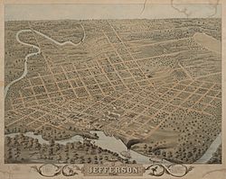
Early records indicate that Jefferson was founded around 1841 on land ceded from the Caddo Indians. At that time, a log jam more than 100 miles long existed on the Red River north of present Natchitoches, Louisiana. The Indians said that this log jam, known as the Great Red River Raft, had always existed.
The Red River Raft (or Great Raft) acted as a dam on the river and raised the level of Caddo Lake and the Red River several feet. This rise of Caddo Lake and the corresponding rise in the Big Cypress Bayou at Jefferson permitted commercial riverboat travel to Jefferson from ports such as St. Louis and New Orleans via the Mississippi and Red Rivers.
Jefferson was one of the most important ports in Texas between 1845 and 1872. The town reached its peak population just a few years after the Civil War and is reported to have exceeded 30,000. During this time, Jefferson was the sixth-largest town in Texas.
There were attempts over the years to remove the raft and permit the normal flow of the Red River, but these attempts were unsuccessful until the discovery of nitroglycerin. In 1873, using nitroglycerin, the Army Corps of Engineers was finally able to clear the raft from the Red River. This lowered the level of Caddo Lake and Big Cypress to the extent that riverboat traffic to Jefferson was no longer commercially feasible. At the peak of river traffic, Jefferson had a population of over 7,000. A few years later, it had dropped to a little over 3,000.
The Sterne Fountain was given to the city in 1913 to honor the contribution of Jacob and Ernestine Sterne, a Jewish couple who settled in Jefferson before the Civil War and became prominent citizens who managed the post office and were involved in numerous civic and cultural projects. The fountain includes a statue of Hebe, the Greek goddess of Youth, by Giuseppe Moretti. [10]
One of the legends related to Jefferson referred to Jay Gould, the railroad magnate. The legend goes that Gould wanted to bring his railroad through Jefferson but the town leaders refused because they had the river traffic. Gould said that "grass would grow in the streets" without the railroad. Gould credited with supporting the removal of the Red River Raft and the subsequent decline of Jefferson as a river port. Much of this tale is fiction. Townspeople obtained Gould's railcar and it is displayed as a tourist attraction in downtown Jefferson. [11]
Since 2000, Jefferson has been the location for the Pulpwood Queens Book Club Girlfriend Weekend's annual conference, attracting authors from all around the country. [12] Home of the famous TJ Blackburn Syrup Works since 1927.
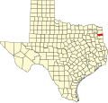
According to the United States Census Bureau, the city has a total area of 4.4 square miles (11 km2), of which 4.3 square miles (11 km2) is land and 0.1 square miles (0.26 km2) (1.58%) is water.
The climate in this area is characterized by hot, humid summers and generally mild to cool winters. According to the Köppen Climate Classification system, Jefferson has a humid subtropical climate, abbreviated "Cfa" on climate maps. [13]
Climate data for Jefferson, Texas (1991–2020 normals, extremes 1903–present) | |||||||||||||
---|---|---|---|---|---|---|---|---|---|---|---|---|---|
Month | Jan | Feb | Mar | Apr | May | Jun | Jul | Aug | Sep | Oct | Nov | Dec | Year |
Record high °F (°C) | 82 (28) | 92 (33) | 89 (32) | 94 (34) | 97 (36) | 107 (42) | 107 (42) | 112 (44) | 109 (43) | 97 (36) | 87 (31) | 88 (31) | 112 (44) |
Mean daily maximum °F (°C) | 56.9 (13.8) | 61.2 (16.2) | 69.1 (20.6) | 76.6 (24.8) | 83.4 (28.6) | 90.6 (32.6) | 94.0 (34.4) | 94.5 (34.7) | 88.7 (31.5) | 78.7 (25.9) | 67.0 (19.4) | 58.9 (14.9) | 76.6 (24.8) |
Daily mean °F (°C) | 45.5 (7.5) | 49.1 (9.5) | 56.8 (13.8) | 64.1 (17.8) | 72.3 (22.4) | 79.9 (26.6) | 83.1 (28.4) | 82.7 (28.2) | 76.2 (24.6) | 65.1 (18.4) | 54.5 (12.5) | 47.2 (8.4) | 64.7 (18.2) |
Mean daily minimum °F (°C) | 34.2 (1.2) | 37.1 (2.8) | 44.4 (6.9) | 51.5 (10.8) | 61.2 (16.2) | 69.3 (20.7) | 72.2 (22.3) | 70.8 (21.6) | 63.6 (17.6) | 51.5 (10.8) | 42.1 (5.6) | 35.4 (1.9) | 52.8 (11.6) |
Record low °F (°C) | 7 (−14) | −4 (−20) | 15 (−9) | 28 (−2) | 38 (3) | 46 (8) | 55 (13) | 52 (11) | 38 (3) | 25 (−4) | 16 (−9) | −5 (−21) | −5 (−21) |
Average precipitation inches (mm) | 4.08 (104) | 4.23 (107) | 4.83 (123) | 4.74 (120) | 5.11 (130) | 5.10 (130) | 2.96 (75) | 2.42 (61) | 3.77 (96) | 4.47 (114) | 3.61 (92) | 4.42 (112) | 49.74 (1,263) |
Average snowfall inches (cm) | 0.5 (1.3) | 0.7 (1.8) | 0.1 (0.25) | 0.0 (0.0) | 0.0 (0.0) | 0.0 (0.0) | 0.0 (0.0) | 0.0 (0.0) | 0.0 (0.0) | 0.0 (0.0) | 0.0 (0.0) | 0.0 (0.0) | 1.3 (3.3) |
Average precipitation days (≥ 0.01 in) | 8.3 | 8.5 | 8.7 | 7.6 | 8.2 | 7.7 | 5.5 | 5.8 | 5.6 | 6.8 | 7.9 | 8.8 | 89.4 |
Average snowy days (≥ 0.1 in) | 0.2 | 0.4 | 0.1 | 0.0 | 0.0 | 0.0 | 0.0 | 0.0 | 0.0 | 0.0 | 0.0 | 0.0 | 0.7 |
Source: NOAA [14] [15] |
Census | Pop. | Note | %± |
---|---|---|---|
1860 | 988 | — | |
1870 | 4,190 | 324.1% | |
1880 | 3,260 | −22.2% | |
1890 | 3,072 | −5.8% | |
1900 | 2,850 | −7.2% | |
1910 | 2,515 | −11.8% | |
1920 | 2,549 | 1.4% | |
1930 | 2,329 | −8.6% | |
1940 | 2,797 | 20.1% | |
1950 | 3,164 | 13.1% | |
1960 | 3,082 | −2.6% | |
1970 | 2,866 | −7.0% | |
1980 | 2,643 | −7.8% | |
1990 | 2,199 | −16.8% | |
2000 | 2,024 | −8.0% | |
2010 | 2,106 | 4.1% | |
2020 | 1,875 | −11.0% | |
U.S. Decennial Census [16] |
Race | Number | Percentage |
---|---|---|
White (NH) | 1,102 | 58.77% |
Black or African American (NH) | 621 | 33.12% |
Native American or Alaska Native (NH) | 12 | 0.64% |
Asian (NH) | 17 | 0.91% |
Some Other Race (NH) | 6 | 0.32% |
Mixed/Multi-Racial (NH) | 72 | 3.84% |
Hispanic or Latino | 45 | 2.4% |
Total | 1,875 |
In the 2010 U.S. census, there were 2,199 people, 871 households, and 544 families residing in the city. [2] The population density was 465.7 inhabitants per square mile (179.8/km2). There were 1,042 housing units at an average density of 239.7 per square mile (92.5/km2). At the 2020 census, its population decreased to 1,875. [7] The racial makeup of the city in 2010 was 62.80% White, 34.68% African American, 0.40% Native American, 0.84% Asian, 0.05% Pacific Islander, 0.54% from other races, and 0.69% from two or more races. Hispanic or Latino of any race were 1.63% of the population; in 2020, its racial and ethnic makeup remained predominantly non-Hispanic white. The city's racial makeup in 2018 was 50.2% non-Hispanic white and 41.5% Black or African American. 2.4% were of two or more races, and 5.9% from some other race; 7.3% were from Hispanic or Latino heritage from any race. [20]
At the 2000 census, the median income for a household in the city was $17,034, and the median income for a family was $26,250. Males had a median income of $28,929 versus $14,583 for females. The per capita income for the city was $15,558. About 29.4% of families and 32.9% of the population were below the poverty line, including 54.1% of those under age 18 and 22.7% of those age 65 or over. At the American Community Survey of 2020, its median household income was $40,306 with a mean income at $67,961. [21]
The city of Jefferson is served by the Jefferson Independent School District.
Marion County is a county located in the U.S. state of Texas. As of the 2020 census, its population was 9,725. Its county seat is Jefferson. Marion County is in East Texas and is named for Francis Marion, the Revolutionary War general from South Carolina who was nicknamed the "Swamp Fox".
Franklin County is a county located in the U.S. state of Texas. As of the 2020 census, its population was 10,359. The county seat is Mount Vernon.
Mooringsport is an incorporated municipality in the U.S. state of Louisiana, located in Caddo Parish. Part of the Shreveport–Bossier City metropolitan area and located approximately 18 miles (29 km) outside of the principal city of Shreveport, the town of Mooringsport had a population of 748 at the 2020 U.S. census.
Oil City is a town in Caddo Parish, Louisiana. The population was 1,008 at the time of the 2010 census. Oil City is located on Louisiana Highway 1, north of Caddo Lake. It is part of the Shreveport–Bossier City Metropolitan Statistical Area.
Troy is a city in Bell County, Texas, United States. The population was 2,375 at the 2020 census. It is part of the Killeen–Temple–Fort Hood Metropolitan Statistical Area.
Maud is a city in Bowie County, Texas, United States, within the Texarkana metropolitan area. According to the 2020 U.S. census, it had a population of 977.
Quitaque is a city in southeastern Briscoe County, Texas, United States. The town lies directly south of Caprock Canyon State Park and is a ranching and farming area in West Texas. The population was 411 at the 2010 census.
Pittsburg is a city in, and the county seat of, Camp County, Texas, United States. Best known as the former home of the giant poultry producer Pilgrim's and the home of racing legend Carroll Shelby, Pittsburg is also the birthplace of Cavender's Boot City. In 1902, it was the site of an early flight attempt by the Ezekiel Air Ship Mfg Co. With a 2020 census-tabulated population of 4,335, it is the most populous city in Camp County.
Rusk is a city and the county seat of Cherokee County in the U.S. state of Texas. At the 2020 United States census, it had a population of 5,285.
Kountze is a city in and the county seat of Hardin County, Texas, United States. The population was 1,981 at the 2020 census. The city is part of the Beaumont–Port Arthur Metropolitan Statistical Area.
Scottsville is a city in Harrison County, Texas, United States. The population was 376 at the 2010 census, up from 263 at the 2000 census. Scottsville's population in 2020 decreased to 334.
Canadian is a city in, and the county seat of, Hemphill County, Texas, United States. The population was 2,649 at the 2010 census, up from 2,233 in 2000. It is named for the nearby Canadian River, a tributary of the Arkansas River. Incorporated in 1908, Canadian is sometimes called "the oasis of the High Plains". Canadian is on the eastern side of the Texas Panhandle, close to the border with Oklahoma.
Itascaeye-TAS-kə is a city in Hill County in Northern Central Texas, United States. As of the 2010 census, the city population was 1,644.
Blossom is a town in Lamar County, Texas, United States. The population was 1,402 at the 2020 census.
Natalia is a city in Medina County, Texas, United States. The population was 1,202 at the 2020 census. It was founded in 1912 and was named after Natalie Pearson Nicholson, daughter of Frederick Stark Pearson, engineer, designer and builder of the Medina Dam.
Friona is a city in Parmer County, Texas, United States. The population was 4,123 at the 2010 census. Friona was established as a small community in 1898 by XIT Ranch, originally called Frio, which is also the word for "cold" in Spanish.
Pecan Gap is a city in Delta and Fannin counties within the U.S. state of Texas. It is sometimes informally referred to as "The Gap" by area residents. The population was 178 at the time of the 2020 census. It is named for the gap between two pecan trees, but unfortunately one of the two pecan trees was destroyed by a tornado in 1963.
Waller is a city in Texas, United States, partly in Waller County and partly in Harris County within the Houston–Cypress metropolitan area. Its population was 2,682 at the 2020 U.S. census. The Waller area is located along U.S. Route 290 41 miles (66 km) northwest of downtown Houston.
Deport is a city in Lamar and Red River counties in the U.S. state of Texas. The population was 550 at the 2020 census.
Caddo Parish is a parish located in the northwestern corner of the U.S. state of Louisiana. According to the 2020 U.S. census, the parish had a population of 237,848. The parish seat is Shreveport, which developed along the Red River.