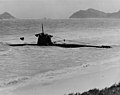
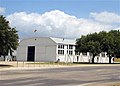
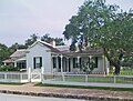
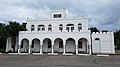
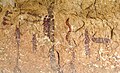
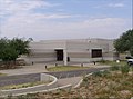
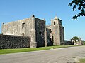
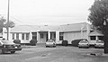
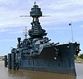
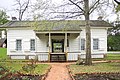
[ Note 1] Landmark name Image Date designated [ Note 2] Location County Description 1 Alamo Alamo December 19, 1960 (# 66000808 San Antonio 29°25′34″N 98°29′10″W / 29.426058°N 98.486084°W / 29.426058; -98.486084 (Alamo ) Bexar Former mission and fortress compound; now a museum; built by the Spanish Empire in the 18th century; later used as a fortress in the 19th century; scene of the 1836 Battle of the Alamo 2 Apollo Mission Control Center Apollo Mission Control Center October 3, 1985 (# 85002815 Houston 29°33′23″N 95°05′18″W / 29.556471°N 95.088460°W / 29.556471; -95.088460 (Apollo Mission Control Center ) Harris NASA control center 3 † Bastrop State Park Bastrop State Park September 25, 1997 (# 97001242 Bastrop 30°06′39″N 97°16′25″W / 30.110833°N 97.273611°W / 30.110833; -97.273611 (Bastrop State Park ) Bastrop This park was designed in the 1930s as a showcase of Civilian Conservation Corps work. Its facilities were designed by CCC architect Herbert Maier . 4 † Dealey Plaza Historic District Dealey Plaza Historic District October 12, 1993 (# 93001607 Dallas 32°46′43″N 96°48′30″W / 32.778611°N 96.808333°W / 32.778611; -96.808333 (Dealey Plaza Historic District ) Dallas Site of President John F. Kennedy's assassination. 5 † East End Historic District East End Historic District May 11, 1976 (# 75001979 Galveston 29°18′16″N 94°46′58″W / 29.304444°N 94.782778°W / 29.304444; -94.782778 (East End Historic District ) Galveston Galveston's East End was where the city elite built a number of elaborate mansions. 6 ELISSA (Bark) ELISSA (Bark) December 14, 1990 (# 78002930 Galveston 29°20′00″N 94°46′39″W / 29.333255°N 94.777452°W / 29.333255; -94.777452 (ELISSA (Bark) Galveston Tall ship launched in 1877 7 Espada Aqueduct Espada Aqueduct July 19, 1964 (# 66000809 San Antonio 29°19′57″N 98°27′41″W / 29.332523°N 98.461469°W / 29.332523; -98.461469 (Espada Aqueduct ) Bexar Built by Franciscan friars in 1731 to supply irrigation water to the lands near Mission San Francisco de la Espada 8 † Fair Park Texas Centennial Buildings Fair Park Texas Centennial Buildings September 24, 1986 (# 86003488 Dallas 32°46′55″N 96°45′56″W / 32.781944°N 96.765556°W / 32.781944; -96.765556 (Fair Park Texas Centennial Buildings ) Dallas Surviving Art Deco buildings from the 1936 Texas Centennial Exposition . 9 Fort Belknap Fort Belknap December 19, 1960 (# 66000824 Newcastle 33°09′03″N 98°44′28″W / 33.150775°N 98.741211°W / 33.150775; -98.741211 (Fort Belknap ) Young Key frontier post of the 1850s; now a museum. 10 † Fort Brown Fort Brown December 19, 1960 (# 66000811 Brownsville 25°53′54″N 97°29′32″W / 25.898333°N 97.492222°W / 25.898333; -97.492222 (Fort Brown ) Cameron Military post of the United States Army in Texas during the latter half of 19th century and the early part of the 20th century 11 † Fort Concho Fort Concho July 4, 1961 (# 66000823 San Angelo 31°27′10″N 100°25′45″W / 31.452778°N 100.429167°W / 31.452778; -100.429167 (Fort Concho ) Tom Green Established as U.S. Army post in 1867; deactivated 1889; comprises most of the original fort 12 § Fort Davis Fort Davis December 19, 1960 (# 66000045 Fort Davis 30°35′45″N 103°55′33″W / 30.595833°N 103.925833°W / 30.595833; -103.925833 (Fort Davis ) Jeff Davis From 1854 to 1891 Fort Davis protected migrants, mail coaches, and freight wagons, and controlled the southern stem of the Great Comanche War Trail and Mescalero Apache war trails. 13 Fort Richardson Fort Richardson November 27, 1963 (# 66000816 Jacksboro 33°12′29″N 98°09′53″W / 33.208056°N 98.164722°W / 33.208056; -98.164722 (Fort Richardson ) Jack This Texas frontier fort was established in 1867 and abandoned in 1878. It was renovated and reopened as a state park in 1973. 14 Fort Sam Houston Fort Sam Houston May 15, 1975 (# 75001950 San Antonio 29°28′35″N 98°25′51″W / 29.476255°N 98.43083°W / 29.476255; -98.43083 (Fort Sam Houston ) Bexar Since the 1870s this facility has served as a major military base for the southern United States. It housed Geronimo following his capture, and has been used as the launching point for a variety of military operations. 15 John Nance Garner House John Nance Garner House December 8, 1976 (# 76002074 Uvalde 29°12′44″N 99°47′31″W / 29.212152°N 99.791837°W / 29.212152; -99.791837 (John Nance Garner House ) Uvalde Home of John Nance Garner , vice president under Franklin Delano Roosevelt 16 Governor's Mansion Governor's Mansion December 2, 1974 (# 70000896 Austin 30°16′20″N 97°44′34″W / 30.272318°N 97.742708°W / 30.272318; -97.742708 (Governor's Mansion ) Travis First designated Texas historic landmark, damaged by arson June 8, 2008 17 HA. 19 (Midget Submarine) HA. 19 (Midget Submarine) June 30, 1989 (# 89001428 Fredericksburg 30°16′20″N 98°52′06″W / 30.272222°N 98.868333°W / 30.272222; -98.868333 (HA. 19 (Midget Submarine) Gillespie Historic I.J.N. Ko-hyoteki class midget submarine; part of the Japanese attack on Pearl Harbor on December 7, 1941; grounded and captured 18 Hangar 9, Brooks Air Force Base Hangar 9, Brooks Air Force Base December 8, 1976 (# 70000895 San Antonio 29°20′32″N 98°26′37″W / 29.342129°N 98.443645°W / 29.342129; -98.443645 (Hangar 9, Brooks Air Force Base ) Bexar Only surviving hangar of 16 built at Brooks Air Force Base (now Brooks City-Base ) in 1918. Now a special events venue. 19 Harrell Site Upload image July 19, 1964 (# 66000825 South Bend Young A late prehistoric Plains Indian archeological site. 20 Highland Park Shopping Village Highland Park Shopping Village February 16, 2000 (# 97001393 Highland Park 32°50′09″N 96°48′20″W / 32.835833°N 96.805556°W / 32.835833; -96.805556 (Highland Park Shopping Village ) Dallas Second shopping mall constructed in the U.S.; opened in 1931, and still in operation 21 Hueco Tanks Hueco Tanks January 13, 2021 (# 100006241 East of El Paso 31°55′13″N 106°02′19″W / 31.9203°N 106.0386°W / 31.9203; -106.0386 (Hueco Tanks ) El Paso State Historic Site (TPWD ) 22 † J A Ranch J A Ranch December 19, 1960 (# 66000807 Amarillo 34°49′00″N 101°11′17″W / 34.816667°N 101.188056°W / 34.816667; -101.188056 (J A Ranch ) Armstrong Founded by John George Adair and Charles Goodnight , this is still one of the largest ranches in the Texas Panhandle , and remains in the hands of Adair descendants. 23 # Lyndon Baines Johnson Boyhood Home Lyndon Baines Johnson Boyhood Home May 23, 1966 (# 69000202 Johnson City 30°14′27″N 98°37′27″W / 30.240833°N 98.624167°W / 30.240833; -98.624167 (Lyndon Baines Johnson Boyhood Home ) Blanco Boyhood home of President Lyndon B. Johnson . Johnson lived here from the age of five until his high school graduation in 1924. 24 † King Ranch King Ranch November 5, 1961 (# 66000820 Kingsville 27°31′07″N 97°55′01″W / 27.518611°N 97.916944°W / 27.518611; -97.916944 (King Ranch ) Kenedy , Kleberg , Nueces , and Willacy Founded in 1853, this is the largest ranch in the United States; it is larger than Rhode Island . 25 Landergin Mesa Upload image July 19, 1964 (# 66000821 Vega Oldham This is a major Panhandle culture archeological site. 26 USS Lexington USS Lexington July 19, 2003 (# 03001043 Corpus Christi 27°48′54″N 97°23′19″W / 27.815°N 97.388611°W / 27.815; -97.388611 (USS Lexington ) Nueces This Essex-class aircraft carrier, known as "The Blue Ghost", was the fifth United States Naval ship named in honor of the Revolutionary War Battle of Lexington . After service in the Second World War and the Cold War, it is now a museum ship. 27 Lower Pecos Canyonlands Archeological District Lower Pecos Canyonlands Archeological District January 13, 2021 (# 100006256 Lower Pecos River watershed area 29°48′N 101°27′W / 29.80°N 101.45°W / 29.80; -101.45 (Lower Pecos Canyonlands Archeological District ) Val Verde Thirty-five mostly discontiguous rock art and other archeological sites; also listed in part in several other NRHP listings in Val Verde County, including Seminole Canyon Archeological District , Lower Pecos Canyon Archeological District , Mile Canyon , and the Rattlesnake Canyon Site . 28 Lubbock Lake Site Lubbock Lake Site December 22, 1977 (# 71000948 Lubbock 33°37′19″N 101°53′23″W / 33.621944°N 101.889722°W / 33.621944; -101.889722 (Lubbock Lake Site ) Lubbock This major archeological site includes evidence from as far back as 10,000BC. The public can view ongoing archeological work at the site. 29 Lucas Gusher, Spindletop Oil Field Lucas Gusher, Spindletop Oil Field November 13, 1966 (# 66000818 Beaumont 30°01′09″N 94°04′26″W / 30.019167°N 94.073889°W / 30.019167; -94.073889 (Lucas Gusher, Spindletop Oil Field ) 30°01′09″N 94°04′26″W / 30.019167°N 94.073889°W / 30.019167; -94.073889 (Lucas Gusher, Spindletop Oil Field ) Jefferson The Spindletop Oil Field was in 1901 where the first major oil gusher of the Texas Oil Boom was discovered. 30 Majestic Theatre Majestic Theatre April 19, 1993 (# 75001952 San Antonio 29°25′35″N 98°29′27″W / 29.426460°N 98.490713°W / 29.426460; -98.490713 (Majestic Theatre ) Bexar This 1929 theater is the largest in Texas and the second largest in the United States. 31 Mission Concepcion Mission Concepcion April 15, 1970 (# 70000740 San Antonio 29°23′27″N 98°29′34″W / 29.390888°N 98.492760°W / 29.390888; -98.492760 (Mission Concepcion ) Bexar Part of San Antonio Missions National Historical Park , this 1731 Spanish mission was also the site of the 1831 Battle of Concepción , and early action in the Texas Revolution . 32 Jose Antonio Navarro House Complex Jose Antonio Navarro House Complex December 23, 2016 (# 100000830 San Antonio 29°25′22″N 98°29′49″W / 29.422778°N 98.496944°W / 29.422778; -98.496944 (Jose Antonio Navarro House Complex ) Bexar Home of Tejano rights advocate José Antonio Navarro , one of only two native-born Texans to sign the Texas Declaration of Independence . 33 Palmito Ranch Battlefield Palmito Ranch Battlefield September 25, 1997 (# 93000266 Brownsville 25°56′48″N 97°17′07″W / 25.946667°N 97.285278°W / 25.946667; -97.285278 (Palmito Ranch Battlefield ) Cameron Site of the 1865 Battle of Palmito Ranch , the last major engagement of the American Civil War . 34 # Palo Alto Battlefield Palo Alto Battlefield December 19, 1960 (# 66000812 Brownsville 26°01′17″N 97°28′50″W / 26.021389°N 97.480556°W / 26.021389; -97.480556 (Palo Alto Battlefield ) Cameron Site of the 1846 Battle of Palo Alto , a precipitating event of the Mexican–American War . 35 Plainview Site Upload image January 20, 1961 (# 66000814 Plainview Hale A major archeological site known for Plainview point spear tips. 36 Walter C. Porter Farm Walter C. Porter Farm July 19, 1964 (# 66000819 Terrell 32°46′40″N 96°16′28″W / 32.777778°N 96.274444°W / 32.777778; -96.274444 (Walter C. Porter Farm ) Kaufman Part of this farm was used as an experimental agricultural farm in the early 20th century. Successful experiments here led to the establishment of the United States Department of Agriculture 's Agricultural Extension Service . 37 Presidio Nuestra Senora De Loreto De La Bahia Presidio Nuestra Senora De Loreto De La Bahia December 24, 1967 (# 67000024 Goliad 28°38′48″N 97°22′54″W / 28.646667°N 97.381667°W / 28.646667; -97.381667 (Presidio Nuestra Senora De Loreto De La Bahia ) Goliad Chapel and former fortress compound; now a museum; built by the Spanish Empire in the 18th century; also used as a fortress in the 19th century; scene of the 1836 Battle of Goliad and Goliad Massacre 38 † Randolph Field Historic District Randolph Field Historic District August 7, 2001 (# 96000753 San Antonio 29°31′56″N 98°16′48″W / 29.532222°N 98.28°W / 29.532222; -98.28 (Randolph Field Historic District ) Bexar The historic core of Randolph Air Force Base , this area was established in the 1920s as a training field for military aviators. 39 Samuel T. Rayburn House Samuel T. Rayburn House May 11, 1976 (# 72001361 Bonham 33°34′05″N 96°12′26″W / 33.567967°N 96.207174°W / 33.567967; -96.207174 (Samuel T. Rayburn House ) Fannin Longtime home of United States Speaker of the House Samuel T. Rayburn 40 Resaca De La Palma Battlefield Resaca De La Palma Battlefield December 19, 1960 (# 66000813 Brownsville 25°56′15″N 97°29′10″W / 25.9375°N 97.486111°W / 25.9375; -97.486111 (Resaca De La Palma Battlefield ) Cameron Site of the 1846 Battle of Resaca de La Palma , fought early in the Mexican–American War . 41 Rio Vista Bracero Reception Center Rio Vista Bracero Reception Center December 11, 2023 (# 100009831 Socorro 31°39′41″N 106°15′59″W / 31.6613°N 106.2663°W / 31.6613; -106.2663 (Rio Vista Bracero Reception Center ) El Paso 42 † Roma Historic District Roma Historic District November 4, 1993 (# 72001371 Roma 26°24′22″N 99°01′05″W / 26.406111°N 99.018056°W / 26.406111; -99.018056 (Roma Historic District ) Starr A well-preserved 19th century Rio Grande border town. 43 San Jacinto Battlefield San Jacinto Battlefield December 19, 1960 (# 66000815 Houston 29°44′56″N 95°04′49″W / 29.748889°N 95.080278°W / 29.748889; -95.080278 (San Jacinto Battlefield ) Harris Site of the decisive Battle of San Jacinto , securing the independence of Texas from Mexico. 44 Space Environment Simulation Laboratory, Chambers A and B Space Environment Simulation Laboratory, Chambers A and B October 3, 1985 (# 85002810 Houston 29°33′32″N 95°05′17″W / 29.559003°N 95.0881°W / 29.559003; -95.0881 (Space Environment Simulation Laboratory, Chambers A and B ) Harris This laboratory for testing equipment in space-like environments has been in use since 1965. 45 Spanish Governor's Palace Spanish Governor's Palace April 15, 1970 (# 70000741 San Antonio 29°25′30″N 98°29′40″W / 29.425082°N 98.494570°W / 29.425082; -98.494570 (Spanish Governor's Palace ) Bexar This early Spanish colonial house was home to aristocratic leaders of the Spanish Texas , and is now a city museum. 46 † Strand Historic District Strand Historic District May 11, 1976 (# 70000748 Galveston 29°18′23″N 94°47′37″W / 29.306389°N 94.793611°W / 29.306389; -94.793611 (Strand Historic District ) Galveston The Victorian downtown of Galveston. 47 USS TEXAS USS TEXAS December 8, 1976 (# 76002039 Houston 29°45′15″N 95°05′22″W / 29.754217°N 95.089499°W / 29.754217; -95.089499 (USS TEXAS ) Harris After seeing action in the First and Second World Wars, this ship was the first United States Navy battleship to become a museum, and the first to be named a National Historic Landmark. 48 Texas State Capitol Texas State Capitol June 23, 1986 (# 70000770 Austin 30°16′22″N 97°44′28″W / 30.272734°N 97.741078°W / 30.272734; -97.741078 (Texas State Capitol ) Travis The seat of Texas government, construction on this Italian Renaissance Revival building began in the 1870s. 49 Trevino-Uribe Rancho Trevino-Uribe Rancho August 5, 1998 (# 73002342 San Ygnacio 27°02′42″N 99°26′36″W / 27.045°N 99.443333°W / 27.045; -99.443333 (Trevino-Uribe Rancho ) Zapata Fortified house built c. 1830, shortly after San Ygnacio's founding. 50 Woodland Woodland May 30, 1974 (# 74002097 Huntsville 30°42′53″N 95°33′10″W / 30.714722°N 95.552778°W / 30.714722; -95.552778 (Woodland ) Walker This modest house was the home of Texas leader Sam Houston in the 1840s and 1850s. 
 Counties with multiple landmarks
 National Historic Landmarks
 National Historic Landmark Districts
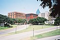
 National Historical Parks
 National Historic Site
 National Historic Landmarks with restricted location (pinned to county, not actual site)