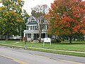
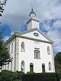
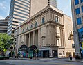
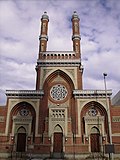
[ 3] Landmark name Image Date designated [ 4] Location County Description 1 Adena Adena February 27, 2003 (# 70000515 Chillicothe 39°21′13″N 83°00′55″W / 39.353613°N 83.015345°W / 39.353613; -83.015345 (Adena ) Ross Mansion of Thomas Worthington 2 Baum-Taft House Baum-Taft House January 7, 1976 (# 73001470 Cincinnati 39°06′09″N 84°30′12″W / 39.1025°N 84.503333°W / 39.1025; -84.503333 (Baum-Taft House ) Hamilton Taft family home now an art museum; designated for landscape murals by African-American artist Robert S. Duncanson . 3 Beginning Point of the U.S. Public Land Survey Beginning Point of the U.S. Public Land Survey June 23, 1965 (# 66000606 East Liverpool, OH and Ohioville, PA 40°38′26″N 80°31′10″W / 40.640487°N 80.519377°W / 40.640487; -80.519377 (Beginning Point of the U.S. Public Land Survey ) Columbiana, OH and Beaver, PA Marker of origin of Northwest Territories survey, on Pennsylvania border 4 Carew Tower-Netherland Plaza Hotel Carew Tower-Netherland Plaza Hotel April 19, 1994 (# 82003578 Cincinnati 39°05′56″N 84°31′31″W / 39.099012°N 84.525224°W / 39.099012; -84.525224 (Carew Tower-Netherland Plaza Hotel ) Hamilton 5 Central Branch, National Home for Disabled Volunteer Soldiers Central Branch, National Home for Disabled Volunteer Soldiers October 16, 2012 (# 03001412 Dayton 39°44′33″N 84°15′52″W / 39.742368°N 84.26458°W / 39.742368; -84.26458 (Central Branch, National Home for Disabled Volunteer Soldiers ) Montgomery 6 Cincinnati Music Hall Cincinnati Music Hall December 2, 1974 (# 70000496 Cincinnati 39°06′32″N 84°31′06″W / 39.108928°N 84.518286°W / 39.108928; -84.518286 (Cincinnati Music Hall ) Hamilton 7 Cincinnati Observatory Cincinnati Observatory December 9, 1997 (# 80003043 Cincinnati 39°08′27″N 84°25′22″W / 39.140935°N 84.422699°W / 39.140935; -84.422699 (Cincinnati Observatory ) Hamilton 8 Cincinnati Union Terminal Cincinnati Union Terminal May 5, 1977 (# 72001018 Cincinnati 39°06′35″N 84°31′56″W / 39.109778°N 84.532190°W / 39.109778; -84.532190 (Cincinnati Union Terminal ) Hamilton 9 Cincinnati Zoo Historic Structures Cincinnati Zoo Historic Structures February 27, 1987 (# 87000905 Cincinnati 39°08′33″N 84°30′34″W / 39.142493°N 84.509395°W / 39.142493; -84.509395 (Cincinnati Zoo Historic Structures ) Hamilton 10 Cleveland Arcade Cleveland Arcade May 15, 1975 (# 73001408 Cleveland 41°29′59″N 81°41′27″W / 41.499702°N 81.690794°W / 41.499702; -81.690794 (Cleveland Arcade ) Cuyahoga 11 USS Cod (Submarine) USS Cod (Submarine) January 14, 1986 (# 86000088 Cleveland 41°30′30″N 81°41′32″W / 41.508328°N 81.692132°W / 41.508328; -81.692132 (USS Cod (Submarine) ) Cuyahoga The USS Cod Submarine Memorial is a National Historic Landmark and is docked in Cleveland, Ohio . 12 Jay Cooke Home Jay Cooke Home November 13, 1966 (# 66000620 Gibraltar Island 41°39′29″N 82°49′16″W / 41.658056°N 82.821111°W / 41.658056; -82.821111 (Jay Cooke Home ) Ottawa Summer home of financier Jay Cooke 13 Covington And Cincinnati Suspension Bridge Covington And Cincinnati Suspension Bridge May 15, 1975 (# 75000786 Cincinnati, OH and Covington, KY 39°05′25″N 84°30′34″W / 39.09039°N 84.509571°W / 39.09039; -84.509571 (Covington And Cincinnati Suspension Bridge ) Hamilton, OH and Kenton, KY John A. Roebling 's suspension bridge here was dramatic new design. It set precedent for Brooklyn Bridge later. 14 Manasseh Cutler Hall, Ohio University Manasseh Cutler Hall, Ohio University December 21, 1965 (# 66000604 Athens 39°19′27″N 82°06′02″W / 39.324184°N 82.100512°W / 39.324184; -82.100512 (Manasseh Cutler Hall, Ohio University ) Athens 15 Donald B. (Towboat) Donald B. (Towboat) December 20, 1989 (# 89002458 Bellaire 40°01′16″N 80°44′17″W / 40.02111°N 80.73805°W / 40.02111; -80.73805 (Donald B. (Towboat) Belmont The Donald B. was built in 1923 and is the only 1920s unchanged diesel sternwheel towboat left in the United States. It still operates towing barges in the Ohio River. [ 5] After years of being located in Switzerland County, Indiana , its home port was moved to Bellaire, Ohio in 2012. [ 6] 16 Paul Laurence Dunbar House Paul Laurence Dunbar House December 29, 1962 (# 66000619 Dayton 39°45′27″N 84°13′07″W / 39.757366°N 84.218681°W / 39.757366; -84.218681 (Paul Laurence Dunbar House ) Montgomery Home of black poet Paul Laurence Dunbar 17 Thomas A. Edison Birthplace Thomas A. Edison Birthplace January 12, 1965 (# 66000608 Milan 41°18′00″N 82°36′16″W / 41.300066°N 82.604437°W / 41.300066; -82.604437 (Thomas A. Edison Birthplace ) Erie 18 Eldean Covered Bridge Eldean Covered Bridge December 23, 2016 (# 100000868 Troy 40°04′40″N 84°13′00″W / 40.077902°N 84.216666°W / 40.077902; -84.216666 (Eldean Covered Bridge ) Miami Only one of twelve long truss bridges still intact. It is considered to be the most structurely intact. [ 7] 19 Wilson Bruce Evans House Wilson Bruce Evans House December 9, 1997 (# 80003143 Oberlin 41°17′20″N 82°12′59″W / 41.288888°N 82.216321°W / 41.288888; -82.216321 (Wilson Bruce Evans House ) Lorain 20 Fallen Timbers Battlefield Fallen Timbers Battlefield October 9, 1960 (# 66000616 Maumee 41°32′32″N 83°41′51″W / 41.542262°N 83.697445°W / 41.542262; -83.697445 (Fallen Timbers Battlefield ) Lucas 21 Fort Ancient Fort Ancient July 19, 1964 (# 66000625 Lebanon 39°24′29″N 84°05′28″W / 39.40806°N 84.0911°W / 39.40806; -84.0911 (Fort Ancient ) Warren 22 Fort Meigs Fort Meigs August 4, 1969 (# 69000151 Perrysburg 41°33′03″N 83°39′05″W / 41.550806°N 83.651523°W / 41.550806; -83.651523 (Fort Meigs ) Wood 23 James A. Garfield Home James A. Garfield Home January 28, 1964 (# 66000613 Mentor 41°39′49″N 81°21′04″W / 41.663616°N 81.351052°W / 41.663616; -81.351052 (James A. Garfield Home ) Lake 24 Joshua R. Giddings Law Office Joshua R. Giddings Law Office May 30, 1974 (# 74001396 Jefferson 41°44′18″N 80°45′47″W / 41.738351°N 80.763127°W / 41.738351; -80.763127 (Joshua R. Giddings Law Office ) Ashtabula 25 Glendale Historic District Glendale Historic District May 5, 1977 (# 76001447 Glendale 39°16′18″N 84°27′49″W / 39.271634°N 84.46362°W / 39.271634; -84.46362 (Glendale Historic District ) Hamilton 26 U.S. Grant Boyhood Home U.S. Grant Boyhood Home February 4, 1985 (# 76001374 Georgetown 38°51′57″N 83°54′08″W / 38.865814°N 83.902148°W / 38.865814; -83.902148 (U.S. Grant Boyhood Home ) Brown 27 Greenhills Historic District Greenhills Historic District December 23, 2016 (# 100000800 Greenhills 39°15′50″N 84°31′28″W / 39.263889°N 84.524444°W / 39.263889; -84.524444 (Greenhills Historic District ) Hamilton 28 Warren G. Harding Home Warren G. Harding Home June 23, 1965 (# 66000618 Marion 40°35′11″N 83°07′18″W / 40.586279°N 83.121691°W / 40.586279; -83.121691 (Warren G. Harding Home ) Marion 29 Hawthorn Hill Hawthorn Hill July 17, 1991 (# 74001585 Oakwood 39°43′13″N 84°10′34″W / 39.720416°N 84.176224°W / 39.720416; -84.176224 (Hawthorn Hill ) Montgomery The Orville Wright mansion. 30 Hopeton Earthworks Hopeton Earthworks July 19, 1964 (# 66000623 Hopetown 39°22′47″N 82°59′08″W / 39.379604°N 82.985474°W / 39.379604; -82.985474 (Hopeton Earthworks ) Ross 31 Huffman Prairie Flying Field Huffman Prairie Flying Field June 21, 1990 (# 71000640 Fairborn 39°48′12″N 84°03′57″W / 39.803333°N 84.065833°W / 39.803333; -84.065833 (Huffman Prairie Flying Field ) Greene 32 Johnson's Island Civil War Prison Johnson's Island Civil War Prison June 21, 1990 (# 75001514 Danbury 41°29′42″N 82°44′12″W / 41.494998°N 82.73675°W / 41.494998; -82.73675 (Johnson's Island Civil War Prison ) Ottawa 33 Charles F. Kettering House Charles F. Kettering House December 22, 1977 (# 77001080 Kettering 39°41′33″N 84°11′34″W / 39.692590°N 84.192796°W / 39.692590; -84.192796 (Charles F. Kettering House ) Montgomery 34 Kirtland Temple Kirtland Temple December 8, 1976 (# 69000145 Kirtland 41°37′33″N 81°21′44″W / 41.625958°N 81.362149°W / 41.625958; -81.362149 (Kirtland Temple ) Lake 35 John Mercer Langston House John Mercer Langston House May 15, 1975 (# 75001464 Oberlin 41°17′30″N 82°12′31″W / 41.291556°N 82.208590°W / 41.291556; -82.208590 (John Mercer Langston House ) Lorain 36 Langstroth Cottage Langstroth Cottage December 21, 1981 (# 76001378 Oxford 39°30′17″N 84°43′49″W / 39.504648°N 84.730223°W / 39.504648; -84.730223 (Langstroth Cottage ) Butler 37 Edward D. Libbey House Edward D. Libbey House May 4, 1983 (# 83004379 Toledo 41°39′38″N 83°33′32″W / 41.660549°N 83.559008°W / 41.660549; -83.559008 (Edward D. Libbey House ) Lucas 38 Benjamin Lundy House Benjamin Lundy House May 30, 1974 (# 74001537 Mt. Pleasant 40°10′29″N 80°48′13″W / 40.17483°N 80.80354°W / 40.17483; -80.80354 (Benjamin Lundy House ) Jefferson 39 MAJESTIC (Showboat) MAJESTIC (Showboat) December 20, 1989 (# 80003085 Cincinnati 39°05′42″N 84°30′17″W / 39.09497°N 84.50467°W / 39.09497; -84.50467 (MAJESTIC (Showboat) Hamilton 40 May 4, 1970, Kent State Shootings Site May 4, 1970, Kent State Shootings Site December 23, 2016 (# 100000879 Kent 41°09′00″N 81°20′36″W / 41.1501°N 81.3433°W / 41.1501; -81.3433 (May 4, 1970, Kent State Shootings Site ) Portage Site of May 4, 1970, shootings of Vietnam War protesters by Ohio National Guardsmen that killed four. 41 William H. McGuffey Boyhood Home Site William H. McGuffey Boyhood Home Site May 23, 1966 (# 66000617 Coitsville Township 41°06′57″N 80°33′31″W / 41.115833°N 80.558611°W / 41.115833; -80.558611 (William H. McGuffey Boyhood Home Site ) Mahoning 42 William H. McGuffey House William H. McGuffey House December 21, 1965 (# 66000605 Oxford 39°30′26″N 84°44′10″W / 39.507230°N 84.736078°W / 39.507230; -84.736078 (William H. McGuffey House ) Butler 43 William McKinley Tomb William McKinley Tomb May 15, 1975 (# 70000516 Canton 40°48′24″N 81°23′33″W / 40.806667°N 81.3925°W / 40.806667; -81.3925 (William McKinley Tomb ) Stark 44 Miami and Erie Canal Deep Cut Miami and Erie Canal Deep Cut January 29, 1964 (# 66000603 Spencerville 40°41′15″N 84°21′55″W / 40.6875°N 84.365278°W / 40.6875; -84.365278 (Miami and Erie Canal Deep Cut ) Allen and Auglaize Mile long segment of the Miami and Erie Canal cut as deep as 52 feet (16 m), in order to cut a trough through a blue clay ridge separating the St. Marys and Auglaize River watersheds 45 Mount Pleasant Historic District Mount Pleasant Historic District April 5, 2005 (# 74001536 Mt. Pleasant 40°10′28″N 80°47′55″W / 40.174444°N 80.798611°W / 40.174444; -80.798611 (Mount Pleasant Historic District ) Jefferson 46 Newark Earthworks Newark Earthworks July 19, 1964 (# 66000614 Heath and Newark 40°02′32″N 82°25′48″W / 40.042167°N 82.430111°W / 40.042167; -82.430111 (Newark Earthworks ) Licking 47 Oberlin College Oberlin College December 21, 1965 (# 66000615 Oberlin 41°17′35″N 82°13′07″W / 41.292929°N 82.218576°W / 41.292929; -82.218576 (Oberlin College ) Lorain 48 Ohio and Erie Canal Ohio and Erie Canal November 13, 1966 (# 66000607 Valley View 41°22′14″N 81°36′59″W / 41.370525°N 81.616442°W / 41.370525; -81.616442 (Ohio and Erie Canal ) Cuyahoga A four mile (6 km) section of canal, including Tinkers Creek Aqueduct 49 Ohio Statehouse Ohio Statehouse December 22, 1977 (# 72001011 Columbus 39°57′41″N 82°59′56″W / 39.961389°N 82.998889°W / 39.961389; -82.998889 (Ohio Statehouse ) Franklin 50 Ohio Theatre Ohio Theatre May 5, 1977 (# 73001437 Columbus 39°57′37″N 82°59′57″W / 39.960281°N 82.999078°W / 39.960281; -82.999078 (Ohio Theatre ) Franklin 51 John P. Parker House John P. Parker House February 18, 1997 (# 97000340 Ripley 38°44′56″N 83°50′56″W / 38.748852°N 83.848872°W / 38.748852; -83.848872 (John P. Parker House ) Brown 52 George Hunt Pendleton House George Hunt Pendleton House January 29, 1964 (# 66000611 Cincinnati 39°06′36″N 84°30′16″W / 39.110102°N 84.504483°W / 39.110102; -84.504483 (George Hunt Pendleton House ) Hamilton 53 Pennsylvania Railroad Depot and Baggage Room Pennsylvania Railroad Depot and Baggage Room June 17, 2011 (# 76001536 Dennison 40°23′32″N 81°19′56″W / 40.392155°N 81.332178°W / 40.392155; -81.332178 (Pennsylvania Railroad Depot and Baggage Room ) Tuscarawas 54 People's Federal Savings and Loan Association People's Federal Savings and Loan Association December 22, 1977 (# 72001042 Sidney 40°17′04″N 84°09′23″W / 40.284410°N 84.156437°W / 40.284410; -84.156437 (People's Federal Savings and Loan Association ) Shelby Louis Sullivan -designed bank building 55 Plum Street Temple Plum Street Temple May 15, 1975 (# 72001021 Cincinnati 39°06′14″N 84°31′07″W / 39.103937°N 84.518678°W / 39.103937; -84.518678 (Plum Street Temple ) Hamilton 56 John Rankin House John Rankin House February 18, 1997 (# 70000485 Ripley 38°45′04″N 83°50′32″W / 38.751111°N 83.842222°W / 38.751111; -83.842222 (John Rankin House ) Brown Home of John Rankin , abolitionist. 57 Captain Edward V. Rickenbacker House Captain Edward V. Rickenbacker House May 11, 1976 (# 76001426 Columbus 39°56′58″N 82°57′44″W / 39.949339°N 82.962179°W / 39.949339; -82.962179 (Captain Edward V. Rickenbacker House ) Franklin 58 S. Bridge, National Road S. Bridge, National Road January 29, 1964 (# 66000610 Old Washington 40°02′36″N 81°22′27″W / 40.043298°N 81.374300°W / 40.043298; -81.374300 (S. Bridge, National Road ) Guernsey 59 Serpent Mound Serpent Mound July 19, 1964 (# 66000602 Locust Grove 39°01′00″N 83°26′00″W / 39.0166666°N 83.433334°W / 39.0166666; -83.433334 (Serpent Mound ) Adams 60 Sherman Birthplace Sherman Birthplace January 29, 1964 (# 66000609 Lancaster 39°42′49″N 82°36′04″W / 39.713722°N 82.600988°W / 39.713722; -82.600988 (Sherman Birthplace ) Fairfield 61 Dr. Bob's Home (Dr. Robert and Anne Smith House) Dr. Bob's Home (Dr. Robert and Anne Smith House) October 16, 2012 (# 85003411 Akron 41°05′45″N 81°32′57″W / 41.095797°N 81.549234°W / 41.095797; -81.549234 (Dr. Bob's Home (Dr. Robert and Anne Smith House) ) Summit Birthplace of Alcoholics Anonymous , [ 8] co-founded by Bob Smith (doctor) 62 Spacecraft Propulsion Research Facility (B-2) Spacecraft Propulsion Research Facility (B-2) October 3, 1985 (# 85002802 Sandusky 41°21′55″N 82°41′01″W / 41.365141°N 82.6837°W / 41.365141; -82.6837 (Spacecraft Propulsion Research Facility (B-2) ) Erie the world's only facility capable of testing full-scale upper-stage launch vehicles and rocket engines under simulated high-altitude conditions. 63 Spiegel Grove (Rutherford B. Hayes Home) Spiegel Grove (Rutherford B. Hayes Home) January 29, 1964 (# 66000624 Fremont 41°20′31″N 83°07′35″W / 41.342037°N 83.126354°W / 41.342037; -83.126354 (Spiegel Grove (Rutherford B. Hayes Home) ) Sandusky Estate of U.S. president Rutherford B. Hayes , now a state park 64 Spring Grove Cemetery Spring Grove Cemetery March 29, 2007 (# 76001440 Cincinnati 39°09′53″N 84°31′23″W / 39.164661°N 84.522949°W / 39.164661; -84.522949 (Spring Grove Cemetery ) Hamilton 65 Stan Hywet Hall Stan Hywet Hall December 21, 1981 (# 75002058 Akron 41°07′02″N 81°32′55″W / 41.117104°N 81.548583°W / 41.117104; -81.548583 (Stan Hywet Hall ) Summit 66 Sunwatch Site Sunwatch Site June 21, 1990 (# 75001500 Dayton 39°42′48″N 84°13′55″W / 39.71321°N 84.231861°W / 39.71321; -84.231861 (Sunwatch Site ) Montgomery 67 Alphonso Taft Home (William Howard Taft Home) Alphonso Taft Home (William Howard Taft Home) January 29, 1964 (# 66000612 Cincinnati 39°06′03″N 84°30′12″W / 39.100707°N 84.503311°W / 39.100707; -84.503311 (Alphonso Taft Home (William Howard Taft Home) ) Hamilton Birthplace and home until age 25 of U.S. President William Howard Taft 68 John B. Tytus House John B. Tytus House May 11, 1976 (# 75001335 Middletown 39°30′47″N 84°24′30″W / 39.513148°N 84.408301°W / 39.513148; -84.408301 (John B. Tytus House ) Butler 69 Harriet Taylor Upton House Harriet Taylor Upton House October 5, 1992 (# 92001884 Warren 41°14′22″N 80°49′21″W / 41.239442°N 80.822558°W / 41.239442; -80.822558 (Harriet Taylor Upton House ) Trumbull 70 Village of Mariemont Village of Mariemont March 29, 2007 (# 07000431 Mariemont 39°08′35″N 84°22′51″W / 39.143056°N 84.380833°W / 39.143056; -84.380833 (Village of Mariemont ) Hamilton 71 W.P. SNYDER, JR. (Towboat) W.P. SNYDER, JR. (Towboat) June 29, 1989 (# 70000522 Marietta 39°25′06″N 81°27′48″W / 39.418301°N 81.463291°W / 39.418301; -81.463291 (W.P. SNYDER, JR. (Towboat) Washington 72 Wright Cycle Company And Wright Printing Shop Wright Cycle Company And Wright Printing Shop June 21, 1990 (# 86000236 Dayton 39°45′20″N 84°12′43″W / 39.755525°N 84.212047°W / 39.755525; -84.212047 (Wright Cycle Company And Wright Printing Shop ) Montgomery 73 Wright Flyer III Wright Flyer III June 21, 1990 (# 90001747 Dayton 39°43′33″N 84°12′07″W / 39.725907°N 84.202073°W / 39.725907; -84.202073 (Wright Flyer III ) Montgomery 1905 Wright Flyer III airplane 74 Colonel Charles Young House Colonel Charles Young House May 30, 1974 (# 74001506 Wilberforce 39°42′26″N 83°53′25″W / 39.707252°N 83.890227°W / 39.707252; -83.890227 (Colonel Charles Young House ) Greene Now the Charles Young Buffalo Soldiers National Monument . 75 Zero Gravity Research Facility Zero Gravity Research Facility October 3, 1985 (# 85002801 Cleveland 41°24′37″N 81°51′51″W / 41.410245°N 81.8641°W / 41.410245; -81.8641 (Zero Gravity Research Facility ) Cuyahoga vacuum chamber where drop tests are conducted to simulate low gravity conditions 76 Zoar Historic District Zoar Historic District October 31, 2016 (# 16000859 Zoar 40°36′47″N 81°25′18″W / 40.613056°N 81.421667°W / 40.613056; -81.421667 (Zoar Historic District ) Tuscarawas Only permanent home of the Society of Separatists in the United States. [ 9]