National Register of Historic Places listings in Geauga County, Ohio

Last updated

Location of Geauga County in Ohio Map of Ohio highlighting Geauga County.svg
Location of Geauga County in Ohio

This is a list of the National Register of Historic Places listings in Geauga County, Ohio.

Contents

This is intended to be a complete list of the properties and districts on the National Register of Historic Places in Geauga County, Ohio, United States. The locations of National Register properties and districts for which the latitude and longitude coordinates are included below, may be seen in a Google map. [1]

There are 18 properties and districts listed on the National Register in the county.


    This National Park Service list is complete through NPS recent listings posted March 4, 2022. [2]

Map all coordinates using: OpenStreetMap  
Download coordinates as: KML

Current listings

[3] Name on the Register [4] ImageDate listed [5] Location City or townDescription
1 ASM Headquarters and Geodesic Dome
ASM Headquarters and Geodesic Dome Russell Township-ASM Headquarters & Geodesic Dome (OHPTC) (5912348229).jpg
ASM Headquarters and Geodesic Dome
October 22, 2009
(#09000849)
9639 Kinsman Rd.
41°27′36″N81°17′56″W / 41.4601°N 81.298968°W / 41.4601; -81.298968 (ASM Headquarters and Geodesic Dome)
Russell Township
2 Batavia House
Batavia House Batavia House 2.jpg
Batavia House
July 16, 1987
(#87001213)
14979 S. State St.
41°27′39″N81°04′22″W / 41.460833°N 81.072778°W / 41.460833; -81.072778 (Batavia House)
Middlefield
3 Burton Village Historic District
Burton Village Historic District Burton village green, northern end.jpg
Burton Village Historic District
November 20, 1974
(#74001501)
Surrounding Public Sq.
41°28′22″N81°08′42″W / 41.472778°N 81.145000°W / 41.472778; -81.145000 (Burton Village Historic District)
Burton
4 Chardon Courthouse Square District
Chardon Courthouse Square District Chardon Courthouse.jpg
Chardon Courthouse Square District
October 18, 1974
(#74001502)
Public green, roughly bounded by Main and Center Sts.
41°34′56″N81°12′14″W / 41.582222°N 81.203889°W / 41.582222; -81.203889 (Chardon Courthouse Square District)
Chardon
5 Chardon Post Office Building
Chardon Post Office Building Old post office in Chardon.jpg
Chardon Post Office Building
February 28, 2008
(#08000114)
121 South St.
41°34′51″N81°12′12″W / 41.580833°N 81.203333°W / 41.580833; -81.203333 (Chardon Post Office Building)
Chardon
6 Chester Township District School No. 2
Chester Township District School No. 2 Chester Township District School No by Joseph Frost.jpg
Chester Township District School No. 2
November 4, 1982
(#82001463)
7798 Mayfield Rd., west of Chesterland
41°31′22″N81°21′46″W / 41.522778°N 81.362778°W / 41.522778; -81.362778 (Chester Township District School No. 2)
Chester Township
7 Claridon Congregational Church
Claridon Congregational Church Claridon Congregational Church.jpg
Claridon Congregational Church
August 13, 1974
(#74001503)
U.S. Route 322
41°31′37″N81°08′35″W / 41.526944°N 81.143056°W / 41.526944; -81.143056 (Claridon Congregational Church)
Claridon Township
8 Domestic Arts Hall And Flower Hall
Domestic Arts Hall And Flower Hall Geauga County Fairgrounds flower hall.jpg
Domestic Arts Hall And Flower Hall
August 24, 1979
(#79001846)
N. Cheshire St.
41°28′37″N81°08′40″W / 41.476944°N 81.144444°W / 41.476944; -81.144444 (Domestic Arts Hall And Flower Hall)
Burton
9 Fowler's Mills Historic District
Fowler's Mills Historic District Fowler's Mills house.jpg
Fowler's Mills Historic District
January 29, 2002
(#01001522)
10743-10779, 10750 Mayfield Rd.; 12426-12533 Fowlers Mill Rd., southwest of Chardon
41°31′41″N81°15′22″W / 41.528056°N 81.256111°W / 41.528056; -81.256111 (Fowler's Mills Historic District)
Munson Township
10 Fox-Pope Farm
Fox-Pope Farm Fox-Pope Farmhouse.jpg
Fox-Pope Farm
August 12, 1992
(#92000971)
17767 Rapids Rd., west of Welshfield
41°23′12″N81°10′17″W / 41.386667°N 81.171389°W / 41.386667; -81.171389 (Fox-Pope Farm)
Troy Township
11 Free Will Baptist Church of Auburn
Free Will Baptist Church of Auburn Free Will Baptist Church of Auburn.jpg
Free Will Baptist Church of Auburn
May 28, 1976
(#76001430)
11742 E. Washington St.
41°23′15″N81°13′08″W / 41.387500°N 81.218750°W / 41.387500; -81.218750 (Free Will Baptist Church of Auburn)
Auburn Township
12 Dr. Erastus Goodwin House
Dr. Erastus Goodwin House Erastus Goodwin House.jpg
Dr. Erastus Goodwin House
August 1, 1975
(#75001406)
14485 Main St.
41°28′28″N81°08′41″W / 41.474444°N 81.144722°W / 41.474444; -81.144722 (Dr. Erastus Goodwin House)
Burton
13 Lot Hathaway House
Lot Hathaway House Lot Hathaway House.jpg
Lot Hathaway House
October 16, 1974
(#74001504)
12236 Old State Rd., north of East Claridon
41°32′08″N81°07′04″W / 41.535556°N 81.117778°W / 41.535556; -81.117778 (Lot Hathaway House)
Claridon Township
14 Lost Lane Farm
Lost Lane Farm Lost Lane Farm wooded hillside.jpg
Lost Lane Farm
August 30, 1984
(#84003693)
18173 Geauga Lake Rd. [6]
41°22′21″N81°21′57″W / 41.372500°N 81.365833°W / 41.372500; -81.365833 (Lost Lane Farm)
Bainbridge Township Associated with Louis Rorimer; also known as Snake Hill Farm [7]
15 Pebblebrook Farm House and Gardens
Pebblebrook Farm House and Gardens Berkshire Hills Country Club, snowy fairways.jpg
Pebblebrook Farm House and Gardens
February 4, 2011
(#10001212)
12525 Heath Rd., east of Chesterland
41°31′45″N81°17′38″W / 41.529167°N 81.293889°W / 41.529167; -81.293889 (Pebblebrook Farm House and Gardens)
Munson Township
16 South Newbury Union Chapel
South Newbury Union Chapel South Newbury Union Chapel.jpg
South Newbury Union Chapel
February 15, 2012
(#12000033)
15829 Ravenna Rd.
41°26′17″N81°12′27″W / 41.438056°N 81.207500°W / 41.438056; -81.207500 (South Newbury Union Chapel)
Newbury Township
17 Lucius T. Tambling House
Lucius T. Tambling House Lucius T. Tambling House.jpg
Lucius T. Tambling House
March 15, 1984
(#84003695)
14025 Chillicothe Rd. at Novelty
41°29′08″N81°20′21″W / 41.485556°N 81.339167°W / 41.485556; -81.339167 (Lucius T. Tambling House)
Russell Township
18 Walter C. White Estate
Walter C. White Estate Walter C white estate by Joseph Frost.jpg
Walter C. White Estate
October 8, 1976
(#76001431)
East of Mayfield Heights at U.S. Route 322 and County Line Rd.
41°31′35″N81°23′14″W / 41.526389°N 81.387222°W / 41.526389; -81.387222 (Walter C. White Estate)
Chester Township

See also

Related Research Articles

National Register of Historic Places listings in Cuyahoga County, Ohio

This is a list of the National Register of Historic Places listings in Cuyahoga County, Ohio.

National Register of Historic Places listings in Summit County, Ohio

This is a list of the National Register of Historic Places listings in Summit County, Ohio.

National Register of Historic Places listings in Lucas County, Ohio

This is a list of the National Register of Historic Places listings in Lucas County, Ohio.

National Register of Historic Places listings in Lake County, Ohio Wikimedia list article

This is a list of the National Register of Historic Places listings in Lake County, Ohio.

National Register of Historic Places listings in Seneca County, Ohio

This is a list of the National Register of Historic Places listings in Seneca County, Ohio.

National Register of Historic Places listings in Ashtabula County, Ohio

This is a list of the National Register of Historic Places listings in Ashtabula County, Ohio.

National Register of Historic Places listings in Miami County, Ohio

This is a list of the National Register of Historic Places listings in Miami County, Ohio.

National Register of Historic Places listings in Trumbull County, Ohio

This is a list of the National Register of Historic Places listings in Trumbull County, Ohio.

National Register of Historic Places listings in Allen County, Ohio

This is a list of the National Register of Historic Places listings in Allen County, Ohio.

National Register of Historic Places listings in Portage County, Ohio

This is a list of the National Register of Historic Places listings in Portage County, Ohio.

National Register of Historic Places listings in Crawford County, Ohio

This is a list of the National Register of Historic Places listings in Crawford County, Ohio.

National Register of Historic Places listings in Clinton County, Ohio

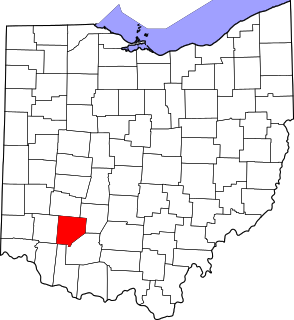
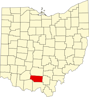
This is a list of the National Register of Historic Places listings in Clinton County, Ohio.

National Register of Historic Places listings in Marion County, Ohio

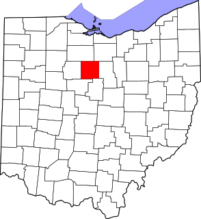
This is a list of the National Register of Historic Places listings in Marion County, Ohio.

National Register of Historic Places listings in Sandusky County, Ohio

This is a list of the National Register of Historic Places listings in Sandusky County, Ohio.

National Register of Historic Places listings in Monroe County, Ohio

This is a list of the National Register of Historic Places listings in Monroe County, Ohio.

National Register of Historic Places listings in Wyandot County, Ohio

This is a list of the National Register of Historic Places listings in Wyandot County, Ohio.

National Register of Historic Places listings in Meigs County, Ohio

This is a list of the National Register of Historic Places listings in Meigs County, Ohio.

National Register of Historic Places listings in Harrison County, Ohio

This is a list of the National Register of Historic Places listings in Harrison County, Ohio.

National Register of Historic Places listings in Pike County, Ohio

This is a list of the National Register of Historic Places listings in Pike County, Ohio.

National Register of Historic Places listings in Williams County, Ohio

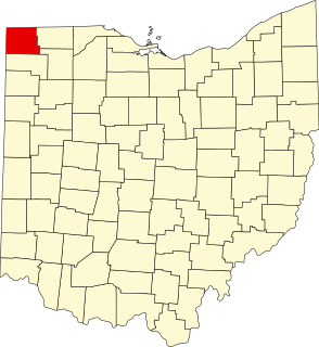
This is a list of the National Register of Historic Places listings in Williams County, Ohio.

References

  1. The latitude and longitude information provided in this table was derived originally from the National Register Information System, which has been found to be fairly accurate for about 99% of listings. Some locations in this table may have been corrected to current GPS standards.
  2. National Park Service, United States Department of the Interior, "National Register of Historic Places: Weekly List Actions", retrieved March 4, 2022.
  3. Numbers represent an alphabetical ordering by significant words. Various colorings, defined here, differentiate National Historic Landmarks and historic districts from other NRHP buildings, structures, sites or objects.
  4. "National Register Information System". National Register of Historic Places . National Park Service. April 24, 2008.
  5. The eight-digit number below each date is the number assigned to each location in the National Register Information System database, which can be viewed by clicking the number.
  6. Location derived from Contact Us Archived 2013-11-27 at the Wayback Machine , Snake Hill Farm, 2012. Accessed 2012-03-16. The NRIS lists the property as "Address Restricted".
  7. Owen, Lorrie K., ed. Dictionary of Ohio Historic Places. Vol. 1. St. Clair Shores: Somerset, 1999, 532.