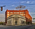
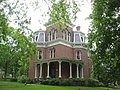
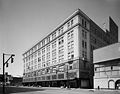
[ 3] Name on the Register Image Date listed [ 4] Location Description 1 Akron Beacon Journal Building Akron Beacon Journal Building December 2, 2021 (# 100007190 44 East Exchange St. 41°04′33″N 81°31′12″W / 41.0757°N 81.5201°W / 41.0757; -81.5201 (Akron Beacon Journal Building ) 2 Akron Jewish Center Akron Jewish Center July 24, 1986 (# 86001919 220 S. Balch St. 41°05′11″N 81°32′04″W / 41.0864°N 81.5344°W / 41.0864; -81.5344 (Akron Jewish Center ) 3 Akron Post Office and Federal Building Akron Post Office and Federal Building May 26, 1983 (# 83002059 168 E. Market St. 41°05′00″N 81°30′49″W / 41.0833°N 81.5136°W / 41.0833; -81.5136 (Akron Post Office and Federal Building ) 4 Akron Public Library Akron Public Library January 19, 1983 (# 83002060 69 E. Market St. 41°05′06″N 81°30′50″W / 41.085°N 81.514°W / 41.085; -81.514 (Akron Public Library ) 5 Akron Rural Cemetery Buildings Akron Rural Cemetery Buildings September 27, 1980 (# 80003236 150 Glendale Ave. 41°05′05″N 81°31′32″W / 41.0847°N 81.5256°W / 41.0847; -81.5256 (Akron Rural Cemetery Buildings ) 6 Akron Soap Company Akron Soap Company September 29, 2014 (# 14000811 237-243 Furnace St. 41°05′20″N 81°30′26″W / 41.0889°N 81.5072°W / 41.0889; -81.5072 (Akron Soap Company ) 7 Akron Temple Israel Synagogue Upload image June 27, 2024 (# 100010462 133 Merriman Road 41°05′48″N 81°32′13″W / 41.0967°N 81.537°W / 41.0967; -81.537 (Akron Temple Israel Synagogue ) 8 Akron Y.M.C.A. Building Akron Y.M.C.A. Building October 31, 1980 (# 80003237 80 W. Center St. 41°04′49″N 81°31′24″W / 41.0803°N 81.5233°W / 41.0803; -81.5233 (Akron Y.M.C.A. Building ) 9 Akron-Fulton International Airport Administration Building Akron-Fulton International Airport Administration Building December 21, 2001 (# 01001361 1800 Triplett Boulevard 41°02′31″N 81°27′47″W / 41.0419°N 81.4631°W / 41.0419; -81.4631 (Akron-Fulton International Airport Administration Building ) 10 B.F. Goodrich Company Historic District Upload image December 21, 2020 (# 100005529 520-540 South Main Street; 115-123 West Bartges Street 41°04′15″N 81°31′35″W / 41.0708°N 81.5263°W / 41.0708; -81.5263 (B.F. Goodrich Company Historic District ) 11 Byron R. Barder House Byron R. Barder House September 17, 1987 (# 87001598 1041 W. Market St. 41°06′01″N 81°33′00″W / 41.1004°N 81.5500°W / 41.1004; -81.5500 (Byron R. Barder House ) 12 Stacy G. Carkhuff House Stacy G. Carkhuff House August 30, 1984 (# 84003804 1225 W. Market St. 41°06′11″N 81°33′15″W / 41.1031°N 81.5542°W / 41.1031; -81.5542 (Stacy G. Carkhuff House ) 13 Cascade Locks Historic District Cascade Locks Historic District December 10, 1992 (# 92001627 Roughly bounded by North, Howard, Innerbelt State Route 59 , and the canal from Locks 10 to 16, including discontiguous parts north 41°05′35″N 81°31′16″W / 41.0931°N 81.5211°W / 41.0931; -81.5211 (Cascade Locks Historic District ) 14 Cole Avenue Housing Project Historic District Cole Avenue Housing Project Historic District October 17, 2007 (# 07001090 744 Colette Dr. 41°03′05″N 81°30′07″W / 41.0515°N 81.5019°W / 41.0515; -81.5019 (Cole Avenue Housing Project Historic District ) 15 Eagles Temple Eagles Temple June 1, 1982 (# 82003656 131-137 E. Market St. 41°05′03″N 81°30′48″W / 41.0842°N 81.5133°W / 41.0842; -81.5133 (Eagles Temple ) 16 East Market Street Church of Christ East Market Street Church of Christ February 7, 1989 (# 88003440 864 E. Market St. 41°04′22″N 81°29′30″W / 41.0728°N 81.4917°W / 41.0728; -81.4917 (East Market Street Church of Christ ) 17 Firestone Tire and Rubber Company Firestone Tire and Rubber Company June 20, 2014 (# 14000338 1200 Firestone Parkway 41°03′06″N 81°31′50″W / 41.0517°N 81.5306°W / 41.0517; -81.5306 (Firestone Tire and Rubber Company ) 18 First Congregational Church First Congregational Church February 20, 2004 (# 04000061 292 E. Market St. 41°04′53″N 81°30′31″W / 41.0814°N 81.5086°W / 41.0814; -81.5086 (First Congregational Church ) 19 First National Bank Tower First National Bank Tower June 27, 2007 (# 07000633 106 S. Main St. 41°04′56″N 81°31′08″W / 41.0822°N 81.5189°W / 41.0822; -81.5189 (First National Bank Tower ) now the Huntington Tower 20 Jacob M. Gayer House Jacob M. Gayer House October 18, 1984 (# 84003442 406 Sumner St. 41°04′19″N 81°30′53″W / 41.0719°N 81.5147°W / 41.0719; -81.5147 (Jacob M. Gayer House ) 21 Glendale Cemetery Glendale Cemetery September 28, 2001 (# 01001063 150 Glendale Ave. 41°05′02″N 81°31′44″W / 41.0839°N 81.5289°W / 41.0839; -81.5289 (Glendale Cemetery ) 22 Glendale Steps Glendale Steps September 28, 2001 (# 100009237 65-99 Glendale Ave. 41°05′08″N 81°31′24″W / 41.0856°N 81.5232°W / 41.0856; -81.5232 (Glendale Steps ) 23 Goodyear Airdock Goodyear Airdock April 11, 1973 (# 73002259 Southern side of the Akron Airport 41°01′55″N 81°28′15″W / 41.0319°N 81.4708°W / 41.0319; -81.4708 (Goodyear Airdock ) 24 Goodyear Hall-Ohio Savings and Trust Company Goodyear Hall-Ohio Savings and Trust Company February 24, 2014 (# 14000030 1201 E. Market St. 41°04′00″N 81°28′58″W / 41.0667°N 81.4828°W / 41.0667; -81.4828 (Goodyear Hall-Ohio Savings and Trust Company ) 25 Goodyear Tire and Rubber Company Headquarters Goodyear Tire and Rubber Company Headquarters August 27, 2013 (# 13000683 1144 E. Market St. 41°03′56″N 81°28′58″W / 41.065556°N 81.482778°W / 41.065556; -81.482778 (Goodyear Tire and Rubber Company Headquarters ) 26 The Gothic Building The Gothic Building May 21, 2010 (# 10000280 102 S. High St. and 52-58 E. Mill St. 41°04′55″N 81°31′01″W / 41.082083°N 81.516944°W / 41.082083; -81.516944 (The Gothic Building ) 27 Grace Reformed Church Grace Reformed Church July 19, 1984 (# 84003806 172 W. Bowery St. 41°05′N 81°31′W / 41.08°N 81.52°W / 41.08; -81.52 (Grace Reformed Church ) 28 Hall Park Allotment Historic District Hall Park Allotment Historic District October 31, 2002 (# 02001274 Roughly along Oakdale Ave., from Crestwood Ave. and Crosby St. 41°05′20″N 81°32′00″W / 41.088889°N 81.533333°W / 41.088889; -81.533333 (Hall Park Allotment Historic District ) 29 Homeier-Universal Motor Company Building Upload image July 15, 2025 (# 100012019 816 E. Market Street 41°04′26″N 81°29′34″W / 41.0738°N 81.4929°W / 41.0738; -81.4929 (Homeier-Universal Motor Company Building ) 30 Hower Mansion Hower Mansion April 11, 1973 (# 73001536 60 Fir Hill 41°04′46″N 81°30′28″W / 41.079556°N 81.507778°W / 41.079556; -81.507778 (Hower Mansion ) 31 Andrew Jackson House Andrew Jackson House February 13, 1975 (# 75001537 277 E. Mill St. 41°04′48″N 81°30′34″W / 41.080000°N 81.509444°W / 41.080000; -81.509444 (Andrew Jackson House ) 32 Kenmore Boulevard Historic District Upload image September 6, 2019 (# 100004354 Roughly bounded by 872-1030; 873-1017 Kenmore Blvd.; 2181 14th St. SW; 2200 15th St. SW; 940 Florida Ave. 41°02′34″N 81°33′37″W / 41.0428°N 81.5604°W / 41.0428; -81.5604 (Kenmore Boulevard Historic District ) 33 Loew's Theatre Loew's Theatre July 16, 1973 (# 73001537 182 S. Main St. 41°04′51″N 81°31′13″W / 41.080833°N 81.520278°W / 41.080833; -81.520278 (Loew's Theatre ) 34 Main Exchange Historic District Main Exchange Historic District November 12, 2009 (# 09000912 1 W. Exchange St., 323-337 S. Main St., 12 E. Exchange St., 380-348 S. Main St., and 328-326 S. Main St. 41°04′36″N 81°31′20″W / 41.076539°N 81.522111°W / 41.076539; -81.522111 (Main Exchange Historic District ) 35 Main-Market Historic District Main-Market Historic District August 1, 2003 (# 03000719 15-47 N. Main St., 1-39 S. Main St., 39-168 E. Market St., 18-42 N. High St., and 70 Broadway St. 41°05′06″N 81°30′59″W / 41.085047°N 81.51635°W / 41.085047; -81.51635 (Main-Market Historic District ) 36 Edwin H. Merrill House Edwin H. Merrill House July 12, 2024 (# 100010492 32 Fir Hill 41°04′50″N 81°30′27″W / 41.0805°N 81.5074°W / 41.0805; -81.5074 (Edwin H. Merrill House ) 37 Wells E. Merriman House Wells E. Merriman House September 29, 1983 (# 83002061 641 W. Market St. 41°05′40″N 81°32′16″W / 41.094444°N 81.537778°W / 41.094444; -81.537778 (Wells E. Merriman House ) 38 Lewis Miller House Lewis Miller House January 30, 1976 (# 76001531 142 King Dr. 41°05′04″N 81°31′23″W / 41.084444°N 81.523056°W / 41.084444; -81.523056 (Lewis Miller House ) 39 O'Neil's Department Store O'Neil's Department Store November 28, 1990 (# 90001776 226-250 S. Main St. 41°04′46″N 81°31′24″W / 41.079444°N 81.523333°W / 41.079444; -81.523333 (O'Neil's Department Store ) 40 Old Akron Post Office Old Akron Post Office June 19, 1972 (# 72001046 70 E. Market St. 41°05′04″N 81°30′55″W / 41.084444°N 81.515278°W / 41.084444; -81.515278 (Old Akron Post Office ) 41 Col. Simon Perkins Mansion Col. Simon Perkins Mansion August 13, 1974 (# 74001624 550 Copley Rd. 41°05′06″N 81°32′31″W / 41.085°N 81.542°W / 41.085; -81.542 (Col. Simon Perkins Mansion ) 42 Portage Hotel Upload image October 17, 1988 (# 80004611 10 N. Main St. 41°05′08″N 81°31′01″W / 41.085556°N 81.516944°W / 41.085556; -81.516944 (Portage Hotel ) 43 Quaker Oats Cereal Factory Quaker Oats Cereal Factory December 8, 1978 (# 78002195 120 E. Mill St. 41°04′50″N 81°30′56″W / 41.080556°N 81.515556°W / 41.080556; -81.515556 (Quaker Oats Cereal Factory ) 44 The Rhodes and Watters Apartment Buildings The Rhodes and Watters Apartment Buildings December 20, 2007 (# 07001296 614, 608, 610, and 612 W. Market St., and 16 Rhodes Ave. 41°05′37″N 81°32′14″W / 41.093611°N 81.537222°W / 41.093611; -81.537222 (The Rhodes and Watters Apartment Buildings ) 45 Byron W. Robinson House Byron W. Robinson House September 20, 1991 (# 91001415 715 E. Buchtel Ave. 41°04′37″N 81°29′43″W / 41.077083°N 81.495278°W / 41.077083; -81.495278 (Byron W. Robinson House ) 46 A. Schrader's Son, Inc. of Ohio Buildings Upload image February 5, 2021 (# 100006104 705-711 Johnston St. 41°03′55″N 81°30′11″W / 41.0652°N 81.5031°W / 41.0652; -81.5031 (A. Schrader's Son, Inc. of Ohio Buildings ) 47 Charles Willard Seiberling House Charles Willard Seiberling House May 6, 1993 (# 93000405 1075 W. Market St. 41°06′06″N 81°33′05″W / 41.101667°N 81.551389°W / 41.101667; -81.551389 (Charles Willard Seiberling House ) 48 Selle Gear Company Selle Gear Company November 9, 2005 (# 05001213 451 S. High St. 41°04′25″N 81°31′20″W / 41.073611°N 81.522222°W / 41.073611; -81.522222 (Selle Gear Company ) 49 Dr. Louis Sisler House Upload image June 7, 2019 (# 100004056 675 N. Portage Path 41°06′58″N 81°32′49″W / 41.116111°N 81.546944°W / 41.116111; -81.546944 (Dr. Louis Sisler House ) 50 Dr. Robert Smith House Dr. Robert Smith House October 31, 1985 (# 85003411 855 Ardmore Ave. 41°05′45″N 81°32′58″W / 41.095833°N 81.549306°W / 41.095833; -81.549306 (Dr. Robert Smith House ) Designated a National Historic Landmark on October 16, 2012 51 South Main Street Historic District South Main Street Historic District July 2, 2008 (# 08000622 156-222 S. Main St., 153-279 S. Main St. 41°04′46″N 81°31′12″W / 41.079381°N 81.520136°W / 41.079381; -81.520136 (South Main Street Historic District ) 52 St. Bernard's Church St. Bernard's Church March 9, 1989 (# 89000174 240 S. Broadway St. 41°04′41″N 81°31′07″W / 41.078056°N 81.518611°W / 41.078056; -81.518611 (St. Bernard's Church ) 53 St. Paul's Sunday School and Parish House St. Paul's Sunday School and Parish House November 7, 1976 (# 76001532 E. Market and Forge Sts. 41°04′51″N 81°30′25″W / 41.080833°N 81.506944°W / 41.080833; -81.506944 (St. Paul's Sunday School and Parish House ) 54 Stan Hywet Hall-Frank A. Seiberling House Stan Hywet Hall-Frank A. Seiberling House January 17, 1975 (# 75002058 714 N. Portage Path 41°07′07″N 81°33′05″W / 41.118611°N 81.551389°W / 41.118611; -81.551389 (Stan Hywet Hall-Frank A. Seiberling House ) 55 Stan Hywet Poultry Keepers Cottage Stan Hywet Poultry Keepers Cottage January 14, 2013 (# 12001183 1103 Courtleigh Dr. 41°07′06″N 81°33′12″W / 41.118333°N 81.553333°W / 41.118333; -81.553333 (Stan Hywet Poultry Keepers Cottage ) 56 Summit County Courthouse and Annex Summit County Courthouse and Annex October 15, 1974 (# 74001625 209 S. High St. 41°04′46″N 81°31′02″W / 41.079544°N 81.517103°W / 41.079544; -81.517103 (Summit County Courthouse and Annex ) 57 University Club Upload image December 2, 2019 (# 100004706 105 Fir Hill 41°04′42″N 81°30′24″W / 41.0784°N 81.5067°W / 41.0784; -81.5067 (University Club ) 58 Valley Railway Historic District Valley Railway Historic District May 17, 1985 (# 85001123 Cuyahoga Valley between Rockside Rd. in the Cuyahoga Valley National Park and Howard St. at Little Cuyahoga Valley 41°13′38″N 81°34′13″W / 41.227222°N 81.570278°W / 41.227222; -81.570278 (Valley Railway Historic District ) Extends into other parts of Summit County and into Cuyahoga County 59 Viall Lodge Viall Lodge March 17, 1994 (# 94000238 1135 E. Market St. 41°04′05″N 81°29′04″W / 41.068056°N 81.484444°W / 41.068056; -81.484444 (Viall Lodge ) 60 Werner Company Building Werner Company Building December 12, 1976 (# 76001533 109 N. Union 41°05′03″N 81°30′21″W / 41.084167°N 81.505833°W / 41.084167; -81.505833 (Werner Company Building ) Demolished 61 Edward P. Werner House Edward P. Werner House October 4, 2005 (# 05001146 258 W. Market St. 41°05′20″N 81°31′34″W / 41.088889°N 81.526111°W / 41.088889; -81.526111 (Edward P. Werner House ) 62 Wesley Temple AME Zion Church Wesley Temple AME Zion Church March 17, 1994 (# 94000243 104 N. Prospect St. 41°05′10″N 81°30′38″W / 41.086111°N 81.510556°W / 41.086111; -81.510556 (Wesley Temple AME Zion Church ) 63 Westmont Building Westmont Building May 31, 1984 (# 84003807 22 Rhodes Ave. 41°05′35″N 81°32′15″W / 41.093194°N 81.537500°W / 41.093194; -81.537500 (Westmont Building ) 64 Young Women's Christian Association Young Women's Christian Association November 4, 1982 (# 82001491 146 S. High St. 41°04′52″N 81°31′03″W / 41.0811°N 81.5175°W / 41.0811; -81.5175 (Young Women's Christian Association )