National Register of Historic Places listings in Clinton County, Ohio

Last updated

Location of Clinton County in Ohio Map of Ohio highlighting Clinton County.svg
Location of Clinton County in Ohio

This is a list of the National Register of Historic Places listings in Clinton County, Ohio.

Contents

This is intended to be a complete list of the properties and districts on the National Register of Historic Places in Clinton County, Ohio, United States. The locations of National Register properties and districts for which the latitude and longitude coordinates are included below, may be seen in a Google map. [1]

There are 18 properties and districts listed on the National Register in the county. Another property was once listed but has been removed.


    This National Park Service list is complete through NPS recent listings posted March 1, 2024. [2]

Current listings

[3] Name on the Register [4] ImageDate listed [5] Location City or townDescription
1 Beam Farm Woodland Archeological District
Beam Farm Woodland Archeological District Beam Farm Woodland Archeological District.jpg
Beam Farm Woodland Archeological District
March 22, 2006
(#05000340)
3983 Stone Rd., southwest of Sabina [6]
39°29′56″N83°42′32″W / 39.498889°N 83.708889°W / 39.498889; -83.708889 (Beam Farm Woodland Archeological District)
Wilson Township
2 College Hall, Wilmington College
College Hall, Wilmington College College Hall at Wilmington College.jpg
College Hall, Wilmington College
April 23, 1973
(#73001399)
East of College St. between Douglas St. and Fife Ave. on the Wilmington College campus
39°26′41″N83°49′06″W / 39.444722°N 83.818333°W / 39.444722; -83.818333 (College Hall, Wilmington College)
Wilmington
3 Cowan Creek Circular Enclosure
Cowan Creek Circular Enclosure Cowan Creek Circular Enclosure.jpg
Cowan Creek Circular Enclosure
July 15, 1974
(#74001422)
Southwest of Wilmington
39°23′24″N83°54′37″W / 39.390000°N 83.910278°W / 39.390000; -83.910278 (Cowan Creek Circular Enclosure)
Vernon Township
4 Doan House
Doan House Doan House in Wilmington.jpg
Doan House
June 20, 1979
(#79001792)
822 Fife Ave.
39°26′41″N83°48′53″W / 39.444722°N 83.814722°W / 39.444722; -83.814722 (Doan House)
Wilmington
5 Frank Haines House
Frank Haines House Frank Haines House.jpg
Frank Haines House
April 1, 1982
(#82003556)
149 W. Elm St.
39°29′23″N83°38′20″W / 39.489722°N 83.638889°W / 39.489722; -83.638889 (Frank Haines House)
Sabina
6 Eli Harvey House
Eli Harvey House E.HarveyHouse.JPG
Eli Harvey House
February 14, 1978
(#78002024)
1133 Lebanon Rd., north of Clarksville
39°26′36″N83°57′37″W / 39.443333°N 83.960278°W / 39.443333; -83.960278 (Eli Harvey House)
Adams Township
7 Hillside Haven Mound
Hillside Haven Mound Hillside Haven Mound.jpg
Hillside Haven Mound
November 21, 1978
(#78002026)
Thousand Trails Campground, 1786 State Route 380 [7] :14
39°27′30″N83°56′14″W / 39.458333°N 83.937222°W / 39.458333; -83.937222 (Hillside Haven Mound)
Adams Township
8 Hurley Mound
Hurley Mound Anderson Fork by the Hurley Mound.jpg
Hurley Mound
May 5, 1978
(#78002025)
East of McKay Rd. above the Anderson Fork, southwest of Lumberton [7] :15
39°33′04″N83°51′49″W / 39.551111°N 83.863611°W / 39.551111; -83.863611 (Hurley Mound)
Liberty Township
9 Keiter Mound October 21, 1975
(#75001346)
In woods west of McKay Rd., atop a bluff overlooking the Anderson Fork [7] :15
39°32′52″N83°52′46″W / 39.547916°N 83.879583°W / 39.547916; -83.879583 (Keiter Mound)
Liberty Township
10 Lynchburg Covered Bridge
Lynchburg Covered Bridge Lynchburg Covered Bridge.jpg
Lynchburg Covered Bridge
March 16, 1976
(#76001456)
East Fork of Little Miami River
39°14′42″N83°47′40″W / 39.245°N 83.794444°W / 39.245; -83.794444 (Lynchburg Covered Bridge)
Lynchburg Extends into Highland County
11 Main Building School November 21, 1980
(#80002960)
Sugartree St.
39°26′36″N83°50′04″W / 39.443333°N 83.834444°W / 39.443333; -83.834444 (Main Building School)
Wilmington Demolished
12 Martinsville Road Covered Bridge
Martinsville Road Covered Bridge MartinsvilleCoveredBridge.JPG
Martinsville Road Covered Bridge
September 10, 1974
(#74001421)
West of Martinsville
39°19′47″N83°50′06″W / 39.329722°N 83.835°W / 39.329722; -83.835 (Martinsville Road Covered Bridge)
Clark Township
13 Pansy Methodist Church and School Historic District
Pansy Methodist Church and School Historic District PansyChurch.JPG
Pansy Methodist Church and School Historic District
March 20, 1973
(#73001398)
South of Clarksville on State Route 730
39°20′55″N83°56′41″W / 39.348611°N 83.944722°W / 39.348611; -83.944722 (Pansy Methodist Church and School Historic District)
Vernon Township
14 Rombach Place
Rombach Place Rombach Place in Wilmington.jpg
Rombach Place
June 20, 1979
(#79001793)
149 E. Locust St.
39°26′48″N83°49′33″W / 39.446667°N 83.825833°W / 39.446667; -83.825833 (Rombach Place)
Wilmington
15 Silk City Diner #4655
Silk City Diner #4655 Silk City Diner 4655 in Sabina.jpg
Silk City Diner #4655
August 10, 2005
(#05000848)
303 Washington St.
39°29′16″N83°38′31″W / 39.487778°N 83.641944°W / 39.487778; -83.641944 (Silk City Diner #4655)
Sabina
16 South South Street Historic District
South South Street Historic District South South Street Historic District.jpg
South South Street Historic District
May 6, 1993
(#93000396)
151-515 S. South St.
39°26′32″N83°49′45″W / 39.442222°N 83.829222°W / 39.442222; -83.829222 (South South Street Historic District)
Wilmington
17 Underwood Farms Rural Historic District
Underwood Farms Rural Historic District Jonahs Run Baptist Church.jpg
Underwood Farms Rural Historic District
January 11, 2006
(#05001519)
Vicinity of State Route 73 and Brimstone Rd.
39°29′47″N83°58′50″W / 39.496389°N 83.980556°W / 39.496389; -83.980556 (Underwood Farms Rural Historic District)
Chester Township
18 Wilmington Commercial Historic District
Wilmington Commercial Historic District Commercial Buildings -- Wilmington, Ohio.jpg
Wilmington Commercial Historic District
October 14, 1982
(#82001363)
Roughly bounded by Columbus, Walnut, Sugartree, and Mulberry Sts.
39°26′44″N83°49′44″W / 39.445556°N 83.828889°W / 39.445556; -83.828889 (Wilmington Commercial Historic District)
Wilmington

Former listing

[3] Name on the RegisterImageDate listedDate removedLocationCity or townDescription
1 Smith Place School
Smith Place School Smith Place School.jpg
Smith Place School
November 25, 1980
(#80002961)
October 29, 1985N. South St.
Wilmington

See also

Related Research Articles

<span class="mw-page-title-main">National Register of Historic Places listings in Delaware County, Ohio</span>

This is a list of the National Register of Historic Places listings in Delaware County, Ohio.

<span class="mw-page-title-main">National Register of Historic Places listings in Warren County, Ohio</span>

This is a list of the National Register of Historic Places listings in Warren County, Ohio.

<span class="mw-page-title-main">National Register of Historic Places listings in Seneca County, Ohio</span>

This is a list of the National Register of Historic Places listings in Seneca County, Ohio.

<span class="mw-page-title-main">National Register of Historic Places listings in Miami County, Ohio</span>

This is a list of the National Register of Historic Places listings in Miami County, Ohio.

<span class="mw-page-title-main">National Register of Historic Places listings in Greene County, Ohio</span>

This is a list of the National Register of Historic Places listings in Greene County, Ohio.

<span class="mw-page-title-main">National Register of Historic Places listings in Allen County, Ohio</span>

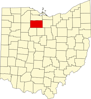
This is a list of the National Register of Historic Places listings in Allen County, Ohio.

<span class="mw-page-title-main">National Register of Historic Places listings in Scioto County, Ohio</span>

This is a list of the National Register of Historic Places listings in Scioto County, Ohio.

<span class="mw-page-title-main">National Register of Historic Places listings in Brown County, Ohio</span>

This is a list of the National Register of Historic Places listings in Brown County, Ohio.

<span class="mw-page-title-main">National Register of Historic Places listings in Clermont County, Ohio</span>

This is a list of the National Register of Historic Places listings in Clermont County, Ohio.

<span class="mw-page-title-main">National Register of Historic Places listings in Highland County, Ohio</span>

This is a list of the National Register of Historic Places listings in Highland County, Ohio.

<span class="mw-page-title-main">National Register of Historic Places listings in Clinton County, Pennsylvania</span>

This is a list of the National Register of Historic Places listings in Clinton County, Pennsylvania.

<span class="mw-page-title-main">National Register of Historic Places listings in Fayette County, Ohio</span>

This is a list of the National Register of Historic Places listings in Fayette County, Ohio.

<span class="mw-page-title-main">National Register of Historic Places listings in Marion County, Ohio</span>

This is a list of the National Register of Historic Places listings in Marion County, Ohio.

<span class="mw-page-title-main">National Register of Historic Places listings in Jackson County, Ohio</span>

This is a list of the National Register of Historic Places listings in Jackson County, Ohio.

<span class="mw-page-title-main">National Register of Historic Places listings in Wyandot County, Ohio</span>

This is a list of the National Register of Historic Places listings in Wyandot County, Ohio.

<span class="mw-page-title-main">National Register of Historic Places listings in Noble County, Ohio</span>

This is a list of the National Register of Historic Places listings in Noble County, Ohio.

<span class="mw-page-title-main">National Register of Historic Places listings in Meigs County, Ohio</span>

This is a list of the National Register of Historic Places listings in Meigs County, Ohio.

<span class="mw-page-title-main">National Register of Historic Places listings in Harrison County, Ohio</span>

This is a list of the National Register of Historic Places listings in Harrison County, Ohio.

<span class="mw-page-title-main">National Register of Historic Places listings in Pike County, Ohio</span>

This is a list of the National Register of Historic Places listings in Pike County, Ohio.

<span class="mw-page-title-main">National Register of Historic Places listings in Williams County, Ohio</span>

This is a list of the National Register of Historic Places listings in Williams County, Ohio.

References

  1. The latitude and longitude information provided in this table was derived originally from the National Register Information System, which has been found to be fairly accurate for about 99% of listings. Some locations in this table may have been corrected to current GPS standards.
  2. National Park Service, United States Department of the Interior, "National Register of Historic Places: Weekly List Actions", retrieved March 1, 2024.
  3. 1 2 Numbers represent an alphabetical ordering by significant words. Various colorings, defined here, differentiate National Historic Landmarks and historic districts from other NRHP buildings, structures, sites or objects.
  4. "National Register Information System". National Register of Historic Places . National Park Service. April 24, 2008.
  5. The eight-digit number below each date is the number assigned to each location in the National Register Information System database, which can be viewed by clicking the number.
  6. Location derived from this Ohio Historical Society webpage; the NRIS lists the site as "Address Restricted"
  7. 1 2 3 Koleszar, Stephen C. An Archaeological Survey of Southwestern Ohio. Columbus: Ohio Historical Society, 1970.