National Register of Historic Places listings in Cuyahoga Valley National Park

Last updated

This is a list of the National Register of Historic Places listings in Cuyahoga Valley National Park.

Contents

This is intended to be a complete list of the properties and districts on the National Register of Historic Places in Cuyahoga Valley National Park, Ohio, United States. The locations of National Register properties and districts for which the latitude and longitude coordinates are included below, may be seen in a Google map. [1]

There are 61 properties and districts listed on the National Register in the park, one of which is a National Historic Landmark.


    This National Park Service list is complete through NPS recent listings posted December 9, 2022. [2]

Map all coordinates using: OpenStreetMap  
Download coordinates as: KML

Current listings

[3] Name on the RegisterImageDate listed [4] Location City or townDescription
1 Barker Village Site
Barker Village Site Barker Village Site.jpg
Barker Village Site
April 19, 1978
(#78000379)
Just north of the old railroad station at Botzum [5]
41°09′56″N81°34′39″W / 41.165556°N 81.577500°W / 41.165556; -81.577500 (Barker Village Site)
Cuyahoga Falls Discovered when the Ohio and Erie Canal was constructed through the site [6]
2 Boston Mills Historic District
Boston Mills Historic District Conger-Jackson House Cuyahoha Valley NP NPS.jpg
Boston Mills Historic District
November 9, 1992
(#92001490)
Roughly Riverview, Boston Mills, and Stanford Rds. and Main St.
41°15′52″N81°33′34″W / 41.264444°N 81.559444°W / 41.264444; -81.559444 (Boston Mills Historic District)
Boston Township
3 Botzum Farm
Botzum Farm Botzum Forebay Barn NPS.jpg
Botzum Farm
October 21, 1999
(#99001271)
3486 Riverview Rd.
41°10′29″N81°34′54″W / 41.174722°N 81.581667°W / 41.174722; -81.581667 (Botzum Farm)
Cuyahoga Falls
4 Jim Brown House
Jim Brown House Jim Brown House NPS.jpg
Jim Brown House
March 2, 1979
(#79000299)
South of Peninsula at 3491 Akron Peninsula Rd.
41°10′54″N81°34′42″W / 41.181667°N 81.578333°W / 41.181667; -81.578333 (Jim Brown House)
Cuyahoga Falls
5 Jim Brown Tavern
Jim Brown Tavern Boston Land and Manufacturing Co Store NPS.jpg
Jim Brown Tavern
December 11, 1979
(#79000300)
Boston Mills Rd.
41°15′48″N81°33′31″W / 41.263333°N 81.558611°W / 41.263333; -81.558611 (Jim Brown Tavern)
Boston Township
6 William Burt House
William Burt House William Burt House site.jpg
William Burt House
March 22, 1979
(#79000286)
9525 Brecksville Rd.
41°18′10″N81°37′36″W / 41.302778°N 81.626667°W / 41.302778; -81.626667 (William Burt House)
Brecksville
7 H. Karl Butler Memorial
H. Karl Butler Memorial H. KARL BUTLER MEMORIAL, CAMP MANATOC, SUMMIT COUNTY, OHIO.jpg
H. Karl Butler Memorial
January 2, 1997
(#96001510)
Truxell Rd., southeast of its junction with Peninsula Rd., Camp Manatoc
41°13′19″N81°31′49″W / 41.221944°N 81.530278°W / 41.221944; -81.530278 (H. Karl Butler Memorial)
Boston Township
8 Camp Manatoc Concord Lodge and Adirondacks Historic District
Camp Manatoc Concord Lodge and Adirondacks Historic District North Elevation, Interior Perspective, Floor Plan, and Details of Timber Connection and Interior Lamp - Manatoc Reservation, Concord Lodge, 1075 Truxell Road, Peninsula, HABS OH-2483-B (sheet 1 of 1).tif
Camp Manatoc Concord Lodge and Adirondacks Historic District
January 2, 1997
(#96001513)
Truxell Rd., southeast of its junction with Peninsula Rd., Camp Manatoc
41°13′07″N81°31′46″W / 41.218611°N 81.529444°W / 41.218611; -81.529444 (Camp Manatoc Concord Lodge and Adirondacks Historic District)
Boston Township
9 Camp Manatoc Dining Hall
Camp Manatoc Dining Hall CAMP MANATOC DINING HALL, SUMMIT COUNTY, OHIO.jpg
Camp Manatoc Dining Hall
January 2, 1997
(#96001511)
Truxell Rd., southeast of its junction with Peninsula Rd., Camp Manatoc
41°13′15″N81°31′44″W / 41.220833°N 81.528889°W / 41.220833; -81.528889 (Camp Manatoc Dining Hall)
Boston Township
10 Camp Manatoc Foresters Lodge and Kit Carson-Dan Boone Cabins Historic District
Camp Manatoc Foresters Lodge and Kit Carson-Dan Boone Cabins Historic District Plan, North and East Elevation, and Foundation Detail - Manatoc Reservation, Dan Boone Cabin, 1075 Truxell Road, Peninsula, Summit County, OH HABS OH-2483-D (sheet 1 of 1).tif
Camp Manatoc Foresters Lodge and Kit Carson-Dan Boone Cabins Historic District
January 2, 1997
(#96001514)
Truxell Rd., southeast of its junction with Peninsula Rd., Camp Manatoc
41°13′39″N81°31′58″W / 41.2275°N 81.532778°W / 41.2275; -81.532778 (Camp Manatoc Foresters Lodge and Kit Carson-Dan Boone Cabins Historic District)
Boston Township
11 Camp Manatoc Legion Lodge
Camp Manatoc Legion Lodge CAMP MANATOC LEGION LODGE, SUMMIT COUNTY, OHIO.jpg
Camp Manatoc Legion Lodge
January 2, 1997
(#96001512)
Truxell Rd., southeast of its junction with Peninsula Rd., Camp Manatoc
41°13′07″N81°31′46″W / 41.218611°N 81.529444°W / 41.218611; -81.529444 (Camp Manatoc Legion Lodge)
Boston Township
12 Albert Cofta Farmstead
Albert Cofta Farmstead Cofta Farmhouse Cuyahoga Valley NP NPS.jpg
Albert Cofta Farmstead
November 4, 2004
(#04001214)
2966 Brush Rd., northeast of Richfield
41°15′13″N81°36′56″W / 41.253611°N 81.615556°W / 41.253611; -81.615556 (Albert Cofta Farmstead)
Richfield Township
13 Jonas Coonrad House
Jonas Coonrad House Jonas Coonrad House NPS.jpg
Jonas Coonrad House
July 24, 1979
(#79000287)
Southeast of Brecksville at 10340 Riverview Rd.
41°16′50″N81°34′21″W / 41.280556°N 81.5725°W / 41.280556; -81.5725 (Jonas Coonrad House)
Brecksville
14 Edward Cranz Farm
Edward Cranz Farm Edward Cranz Farm House NPS.jpg
Edward Cranz Farm
March 12, 1993
(#93000077)
2780 Oak Hill Dr., south of Peninsula
41°11′50″N81°35′31″W / 41.197222°N 81.591944°W / 41.197222; -81.591944 (Edward Cranz Farm)
Bath Township
15 William and Eugene Cranz Farm
William and Eugene Cranz Farm WILLIAM AND EUGENE CRANZ FARM, PENINSULA, SUMMIT COUNTY.jpg
William and Eugene Cranz Farm
March 12, 1993
(#93000078)
2401 Ira Rd., south of Peninsula
41°11′15″N81°35′31″W / 41.1875°N 81.591944°W / 41.1875; -81.591944 (William and Eugene Cranz Farm)
Bath Township
16 Michael Duffy Farm
Michael Duffy Farm Michael Duffy Bank Barn NPS.jpg
Michael Duffy Farm
March 12, 1993
(#93000079)
4965 Quick Rd., southeast of Peninsula
41°12′15″N81°30′58″W / 41.204167°N 81.516111°W / 41.204167; -81.516111 (Michael Duffy Farm)
Boston Township
17 Everett Historic District
Everett Historic District Robert Gracey House NPS.jpg
Everett Historic District
January 14, 1993
(#93001467)
4731-4642 Riverview Rd. and 2151-2279 Everett Rd., south of Peninsula, in the Cuyahoga Valley National Park
41°12′16″N81°34′29″W / 41.204444°N 81.574722°W / 41.204444; -81.574722 (Everett Historic District)
Boston Township
18 Everett Knoll Complex
Everett Knoll Complex Everett Knoll from west.jpg
Everett Knoll Complex
May 25, 1977
(#77000157)
Southern side of Everett Rd., west of its junction with Riverview Rd. [7]
41°12′16″N81°34′33″W / 41.204306°N 81.575764°W / 41.204306; -81.575764 (Everett Knoll Complex)
Boston Township
19 Stephen Frazee House
Stephen Frazee House Stephen Frazee House NPS.jpg
Stephen Frazee House
May 4, 1976
(#76000211)
7733 Canal Rd.
41°21′10″N81°35′34″W / 41.352778°N 81.592778°W / 41.352778; -81.592778 (Stephen Frazee House)
Valley View
20 Furnace Run Aqueduct
Furnace Run Aqueduct Furnace Run Aqueduct site.jpg
Furnace Run Aqueduct
December 11, 1979
(#79000301)
Furnace Run
41°12′06″N81°34′22″W / 41.201667°N 81.572778°W / 41.201667; -81.572778 (Furnace Run Aqueduct)
Cuyahoga Falls
21 Edmund Gleason House
Edmund Gleason House Edmond Gleeson House NPS.jpg
Edmund Gleason House
December 18, 1978
(#78000377)
7243 Canal Rd.
41°22′02″N81°36′38″W / 41.367222°N 81.610556°W / 41.367222; -81.610556 (Edmund Gleason House)
Valley View
22 Hunt-Wilke Farm
Hunt-Wilke Farm Hunt-Wilke Farm.jpg
Hunt-Wilke Farm
March 12, 1993
(#93000080)
2049 Bolanz Rd.
41°12′04″N81°34′19″W / 41.201111°N 81.571944°W / 41.201111; -81.571944 (Hunt-Wilke Farm)
Cuyahoga Falls
23 Jaite Mill Historic District
Jaite Mill Historic District Jaite Company Store-Post Office NPS.jpg
Jaite Mill Historic District
May 21, 1979
(#79000288)
Southeast of Brecksville at Riverview and Vaughan Rds.
41°17′10″N81°34′06″W / 41.286111°N 81.568333°W / 41.286111; -81.568333 (Jaite Mill Historic District)
Sagamore Hills Township
24 Virginia Kendall State Park Historic District
Virginia Kendall State Park Historic District Happy Days Shelter.jpg
Virginia Kendall State Park Historic District
January 2, 1997
(#96001515)
701, 801, and 1000 Truxell Rd. and 434 W. Streetsboro, southeast of Peninsula
41°13′04″N81°31′15″W / 41.217778°N 81.520833°W / 41.217778; -81.520833 (Virginia Kendall State Park Historic District)
Boston Township
25 William Knapp House
William Knapp House William Knapp House NPS.jpg
William Knapp House
March 19, 1979
(#79000289)
7101 Canal Rd.
41°22′20″N81°36′42″W / 41.372222°N 81.611667°W / 41.372222; -81.611667 (William Knapp House)
Valley View
26 Lock No. 26
Lock No. 26 Lock 26 Pancake Lock NPS.jpg
Lock No. 26
December 11, 1979
(#79000302)
3.3 mi (5.3 km) north of Ira Rd.
41°11′08″N81°34′53″W / 41.185556°N 81.581389°W / 41.185556; -81.581389 (Lock No. 26)
Cuyahoga Falls
27 Lock No. 27
Lock No. 27 Lock 27 Johnny Cake Lock.jpg
Lock No. 27
December 11, 1979
(#79000303)
Approximately 400 ft (120 m) east of the intersection of Riverview and Everett Rds. at Everett
41°12′11″N81°34′15″W / 41.203056°N 81.570833°W / 41.203056; -81.570833 (Lock No. 27)
Boston Township
28 Lock No. 28
Lock No. 28 Lock No. 28, Ohio and Erie Canal.jpg
Lock No. 28
December 11, 1979
(#79000304)
Deep Lock Q Quarry Metro Park
41°13′58″N81°33′09″W / 41.232778°N 81.5525°W / 41.232778; -81.5525 (Lock No. 28)
Peninsula
29 Lock No. 29 and Aqueduct
Lock No. 29 and Aqueduct Peninsula Lock.jpg
Lock No. 29 and Aqueduct
December 11, 1979
(#79000305)
Off State Route 303
41°14′34″N81°33′02″W / 41.242778°N 81.550556°W / 41.242778; -81.550556 (Lock No. 29 and Aqueduct)
Peninsula
30 Lock No. 30 and Feeder Dam
Lock No. 30 and Feeder Dam Lock 30 Feeder NPS.jpg
Lock No. 30 and Feeder Dam
December 11, 1979
(#79000306)
Off State Route 303
41°14′41″N81°33′14″W / 41.244722°N 81.553889°W / 41.244722; -81.553889 (Lock No. 30 and Feeder Dam)
Peninsula
31 Lock No. 31
Lock No. 31 Lock 31 Lonesome Lock NPS.jpg
Lock No. 31
December 11, 1979
(#79000307)
200 ft (61 m) east of the Cuyahoga River and approximately 0.5 mi (0.80 km) south of the Ohio Turnpike
41°15′06″N81°32′46″W / 41.251667°N 81.546111°W / 41.251667; -81.546111 (Lock No. 31)
Peninsula
32 Lock No. 32
Lock No. 32 Lock 32 Boston Lock NPS.jpg
Lock No. 32
December 11, 1979
(#79000308)
800 ft (240 m) north of Boston Mills
41°15′58″N81°33′32″W / 41.266111°N 81.558889°W / 41.266111; -81.558889 (Lock No. 32)
Boston Township
33 Lock No. 33
Lock No. 33 Lock 33 Ohio & Erie Canal NPS.jpg
Lock No. 33
December 11, 1979
(#79000309)
1 mi (1.6 km) south of Highland Rd.
41°16′36″N81°33′40″W / 41.276667°N 81.561111°W / 41.276667; -81.561111 (Lock No. 33)
Boston Township
34 Lock No. 34
Lock No. 34 Lock 34 Red Lock NPS.jpg
Lock No. 34
December 17, 1979
(#79000310)
Highland Rd.
41°17′21″N81°33′53″W / 41.289167°N 81.564722°W / 41.289167; -81.564722 (Lock No. 34)
Sagamore Hills Township
35 Lock No. 35
Lock No. 35 Lock 35 Kettlewell Lock.jpg
Lock No. 35
December 11, 1979
(#79000311)
Off State Route 82
41°18′38″N81°34′56″W / 41.310556°N 81.582222°W / 41.310556; -81.582222 (Lock No. 35)
Sagamore Hills Township
36 Lock No. 37 and Spillway
Lock No. 37 and Spillway Lock No. 37, Ohio and Erie Canal.jpg
Lock No. 37 and Spillway
December 11, 1979
(#79000290)
Fitzwater Rd.
41°21′24″N81°35′50″W / 41.356667°N 81.597222°W / 41.356667; -81.597222 (Lock No. 37 and Spillway)
Valley View
37 Lock No. 38 and Spillway
Lock No. 38 and Spillway Lock No. 38, Ohio and Erie Canal.jpg
Lock No. 38 and Spillway
December 11, 1979
(#79000291)
Hillside Rd.
41°22′21″N81°36′46″W / 41.372597°N 81.612792°W / 41.372597; -81.612792 (Lock No. 38 and Spillway)
Valley View
38 Lock No. 39 and Spillway
Lock No. 39 and Spillway Lock No. 39, Ohio and Erie Canal.jpg
Lock No. 39 and Spillway
December 11, 1979
(#79000292)
Canal Rd.
41°23′25″N81°37′30″W / 41.390278°N 81.625°W / 41.390278; -81.625 (Lock No. 39 and Spillway)
Valley View
39 Lock Tender's House and Inn
Lock Tender's House and Inn Lock Tender's House and Inn.JPG
Lock Tender's House and Inn
December 11, 1979
(#79000293)
7104 Canal Rd.
41°22′21″N81°36′47″W / 41.3725°N 81.613056°W / 41.3725; -81.613056 (Lock Tender's House and Inn)
Valley View
40 Lutz-Martin Farm
Lutz-Martin Farm Peter Martin Farm House NPS.jpg
Lutz-Martin Farm
July 3, 2003
(#03000608)
2470 Martin Rd.
41°10′28″N81°35′30″W / 41.174444°N 81.591667°W / 41.174444; -81.591667 (Lutz-Martin Farm)
Bath Township
41 Ohio and Erie Canal
Ohio and Erie Canal Ohio Canal.jpg
Ohio and Erie Canal
November 13, 1966
(#66000607)
State Route 631
41°22′14″N81°36′59″W / 41.370556°N 81.616389°W / 41.370556; -81.616389 (Ohio and Erie Canal)
Valley View
42 Ohio and Erie Canal Deep Lock
Ohio and Erie Canal Deep Lock DEEP LOCK, DEEPEST OF THE 40 LOCKS IN THE OHIO-ERIE CANAL SYSTEM BETWEEN CLEVELAND AND AKRON, OHIO. IT IS LOCATED IN... - NARA - 558014.jpg
Ohio and Erie Canal Deep Lock
September 9, 1974
(#74000345)
South of Peninsula on Riverview Rd.
41°13′58″N81°33′09″W / 41.232778°N 81.5525°W / 41.232778; -81.5525 (Ohio and Erie Canal Deep Lock)
Peninsula
43 Packard-Doubler House
Packard-Doubler House Packard-Doubler House NPS.jpg
Packard-Doubler House
March 9, 1979
(#79000294)
7634 Riverview Rd.
41°21′18″N81°36′12″W / 41.355°N 81.603333°W / 41.355; -81.603333 (Packard-Doubler House)
Independence
44 Peninsula Village Historic District
Peninsula Village Historic District Peninsula United Methodist Church.jpg
Peninsula Village Historic District
August 23, 1974
(#74000346)
Both sides of State Route 303
41°14′24″N81°33′03″W / 41.24°N 81.550833°W / 41.24; -81.550833 (Peninsula Village Historic District)
Peninsula
45 Nathaniel Point Farm
Nathaniel Point Farm Nathaniel Point House NPS.jpg
Nathaniel Point Farm
September 3, 1999
(#99001084)
4606 and 4631 Akron-Peninsula Rd., south of Peninsula
41°12′20″N81°33′46″W / 41.205556°N 81.562778°W / 41.205556; -81.562778 (Nathaniel Point Farm)
Boston Township
46 Charles B. Rich House
Charles B. Rich House Charles B. Rich House.jpg
Charles B. Rich House
February 22, 1979
(#79000295)
9367 Brecksville Rd.
41°18′25″N81°37′36″W / 41.306944°N 81.626667°W / 41.306944; -81.626667 (Charles B. Rich House)
Brecksville
47 Russ and Holland Snow Houses
Russ and Holland Snow Houses Holland Snow House.jpg
Russ and Holland Snow Houses
September 28, 1982
(#82001873)
12911 and 13114 Snowville Rd.
41°16′59″N81°35′39″W / 41.283056°N 81.594167°W / 41.283056; -81.594167 (Russ and Holland Snow Houses)
Brecksville
48 South Park Site
South Park Site DiGeronimo Aggregates quarry in Independence.jpg
South Park Site
June 22, 1976
(#76000212)
On a promontory above the western bank of the Cuyahoga River, 7 miles from Lake Erie [8]
41°22′43″N81°37′20″W / 41.3785°N 81.6222°W / 41.3785; -81.6222 (South Park Site)
Independence
49 George Stanford Farm
George Stanford Farm George Stanford House NPS.jpg
George Stanford Farm
February 17, 1982
(#82001874)
6093 Stanford Rd., north of Peninsula
41°16′16″N81°33′25″W / 41.271111°N 81.556944°W / 41.271111; -81.556944 (George Stanford Farm)
Boston Township
50 Station Road Bridge
Station Road Bridge Station Road Bridge (Brecksville, Ohio).jpg
Station Road Bridge
March 7, 1979
(#79000312)
East of Brecksville at the Cuyahoga River
41°19′10″N81°35′16″W / 41.319444°N 81.587778°W / 41.319444; -81.587778 (Station Road Bridge)
Sagamore Hills Township
51 Stebbens Farm
Stebbens Farm Barn seen from Riverview Road.jpg
Stebbens Farm
April 17, 1996
(#96000381)
8255 Riverview Rd.
41°20′19″N81°35′40″W / 41.338611°N 81.594444°W / 41.338611; -81.594444 (Stebbens Farm)
Brecksville
52 Stumpy Basin
Stumpy Basin STUMPY BASIN LOCK ON THE OHIO-ERIE CANAL WHERE THE BOATS TURNED AROUND, NORTHEAST OF PENINSULA, OHIO, NEAR CLEVELAND... - NARA - 558011.jpg
Stumpy Basin
December 11, 1979
(#79000313)
200 ft (61 m) east of the Cuyahoga River and approximately 0.5 mi (0.80 km) south of the Ohio Turnpike, north of Peninsula
41°15′09″N81°32′45″W / 41.2525°N 81.545833°W / 41.2525; -81.545833 (Stumpy Basin)
Boston Township
53 Terra Vista Archeological District
Terra Vista Archeological District Terra Vista Archaeological HD.jpg
Terra Vista Archeological District
May 23, 1978
(#78000378)
On the edge of a bluff above the Cuyahoga River, north of its confluence with Tinkers Creek [9]
41°22′06″N81°36′37″W / 41.3683°N 81.6103°W / 41.3683; -81.6103 (Terra Vista Archeological District)
Valley View
54 Daniel Tilden House
Daniel Tilden House Daniel Tilden House NPS.jpg
Daniel Tilden House
June 20, 1985
(#85001340)
2325 Stine Rd., west of Peninsula
41°14′48″N81°35′17″W / 41.246667°N 81.588056°W / 41.246667; -81.588056 (Daniel Tilden House)
Boston Township
55 Tinkers Creek Aqueduct
Tinkers Creek Aqueduct Tctcaque.JPG
Tinkers Creek Aqueduct
December 11, 1979
(#79000296)
Tinkers Creek
41°21′53″N81°36′33″W / 41.364722°N 81.609167°W / 41.364722; -81.609167 (Tinkers Creek Aqueduct)
Valley View
56 Abraham Ulyatt House
Abraham Ulyatt House Abraham Ulyatt House Cuyahoga Valley NP NPS.jpg
Abraham Ulyatt House
February 27, 1979
(#79000297)
6579 Canal Rd.
41°23′10″N81°37′11″W / 41.386111°N 81.619722°W / 41.386111; -81.619722 (Abraham Ulyatt House)
Valley View
57 Valley Railway Historic District
Valley Railway Historic District Valley Railway from Hickory Street in Akron.jpg
Valley Railway Historic District
May 17, 1985
(#85001123)
Cuyahoga Valley between Rockside Rd. at the Cuyahoga Valley National Park and Howard St. at Little Cuyahoga Valley
41°13′38″N81°34′13″W / 41.227222°N 81.570278°W / 41.227222; -81.570278 (Valley Railway Historic District)
Brecksville and Independence
58 Richard Vaughn Farm
Richard Vaughn Farm Richard Vaughn Farmhouse NPS.jpg
Richard Vaughn Farm
March 12, 1993
(#93000081)
9570 Riverview Rd.
41°18′03″N81°34′58″W / 41.300833°N 81.582778°W / 41.300833; -81.582778 (Richard Vaughn Farm)
Brecksville
59 Wallace Farm
Wallace Farm James Wallace Barn, Northfield Center.jpg
Wallace Farm
June 27, 1985
(#85001387)
8230 Brandywine Rd.
41°16′40″N81°32′26″W / 41.277778°N 81.540556°W / 41.277778; -81.540556 (Wallace Farm)
Northfield Center Township
60 Allen Welton House
Allen Welton House Allen Welton House NPS.jpg
Allen Welton House
May 7, 1979
(#79000314)
Southwest of Peninsula at 2485 Major Rd.
41°14′00″N81°35′01″W / 41.233333°N 81.583611°W / 41.233333; -81.583611 (Allen Welton House)
Boston Township
61 Wilson Feed Mill
Wilson Feed Mill WILSON'S MILL, FORMERLY KNOWN AS ALEXANDER'S MILL, ON THE OHIO-ERIE CANAL SOUTH OF ALEXANDER ROAD NEAR VALLEY VIEW... - NARA - 558001.jpg
Wilson Feed Mill
December 17, 1979
(#79000298)
7604 Canal Rd.
41°21′22″N81°35′48″W / 41.356111°N 81.596667°W / 41.356111; -81.596667 (Wilson Feed Mill)
Valley View

See also

Related Research Articles

<span class="mw-page-title-main">National Register of Historic Places listings in Fayette County, Pennsylvania</span>

This is a list of the National Register of Historic Places listings in Fayette County, Pennsylvania.

<span class="mw-page-title-main">National Register of Historic Places listings in Cuyahoga County, Ohio</span>

This is a list of the National Register of Historic Places listings in Cuyahoga County, Ohio.

<span class="mw-page-title-main">National Register of Historic Places listings in Summit County, Ohio</span>

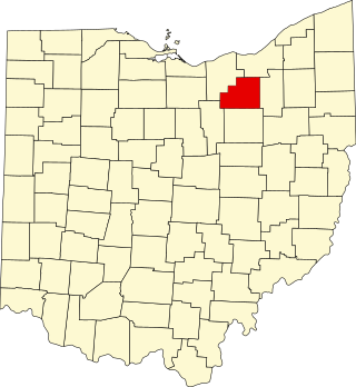
This is a list of the National Register of Historic Places listings in Summit County, Ohio.

<span class="mw-page-title-main">National Register of Historic Places listings in Delaware County, Ohio</span>

This is a list of the National Register of Historic Places listings in Delaware County, Ohio.

<span class="mw-page-title-main">National Register of Historic Places listings in Lorain County, Ohio</span>

This is a list of the National Register of Historic Places listings in Lorain County, Ohio.

<span class="mw-page-title-main">National Register of Historic Places listings in Fairfield County, Ohio</span>

This is a list of the National Register of Historic Places listings in Fairfield County, Ohio.

<span class="mw-page-title-main">National Register of Historic Places listings in Lake County, Ohio</span>

This is a list of the National Register of Historic Places listings in Lake County, Ohio.

<span class="mw-page-title-main">National Register of Historic Places listings in Ashtabula County, Ohio</span>

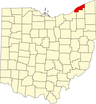
This is a list of the National Register of Historic Places listings in Ashtabula County, Ohio.

<span class="mw-page-title-main">National Register of Historic Places listings in Clermont County, Ohio</span>

This is a list of the National Register of Historic Places listings in Clermont County, Ohio.

<span class="mw-page-title-main">National Register of Historic Places listings in Belmont County, Ohio</span>

This is a list of the National Register of Historic Places listings in Belmont County, Ohio.

<span class="mw-page-title-main">National Register of Historic Places listings in Medina County, Ohio</span>

This is a list of the National Register of Historic Places listings in Medina County, Ohio.

<span class="mw-page-title-main">National Register of Historic Places listings in Adams County, Ohio</span>

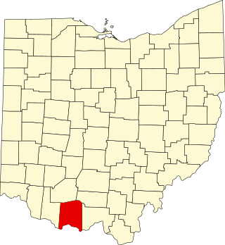
This is a list of the National Register of Historic Places listings in Adams County, Ohio.

<span class="mw-page-title-main">National Register of Historic Places listings in Greene County, Pennsylvania</span>

This is a list of the National Register of Historic Places listings in Greene County, Pennsylvania.

<span class="mw-page-title-main">National Register of Historic Places listings in Geauga County, Ohio</span>

This is a list of the National Register of Historic Places listings in Geauga County, Ohio.

<span class="mw-page-title-main">National Register of Historic Places listings in Dearborn County, Indiana</span>

This is a list of the National Register of Historic Places listings in Dearborn County, Indiana.

This is a list of the properties and historic districts in Stamford, Connecticut that are listed on the National Register of Historic Places. The locations of National Register properties and districts for which the latitude and longitude coordinates are included below, may be seen in an online map.

This is a list of the National Register of Historic Places listings in Greenwich, Connecticut.

<span class="mw-page-title-main">National Register of Historic Places listings in Southington, Connecticut</span>

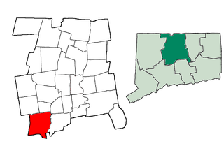
This is a list of the National Register of Historic Places listings in Southington, Connecticut.

This is a list of the National Register of Historic Places listings in Grand Teton National Park.

This is a complete list of the properties and districts on the National Register of Historic Places in Rocky Mountain National Park, Colorado, United States. The locations of National Register properties and districts for which the latitude and longitude coordinates are included below, may be seen in a Google map.

References

  1. The latitude and longitude information provided in this table was derived originally from the National Register Information System, which has been found to be fairly accurate for about 99% of listings. Some locations in this table may have been corrected to current GPS standards.
  2. National Park Service, United States Department of the Interior, "National Register of Historic Places: Weekly List Actions", retrieved December 9, 2022.
  3. Numbers represent an alphabetical ordering by significant words. Various colorings, defined here, differentiate National Historic Landmarks and historic districts from other NRHP buildings, structures, sites or objects.
  4. The eight-digit number below each date is the number assigned to each location in the National Register Information System database, which can be viewed by clicking the number.
  5. Perrin, William Henry, ed. History of Summit County, with an Outline Sketch of Ohio. Chicago: Baskin and Battey, 1881, 213.
  6. Bush, David R. National Register of Historic Places Inventory/Nomination: Barker Village Site. National Park Service, 1975-11-12, 2.
  7. Brose, David S. "The Everett Knoll: A Late Hopewellian Site in Northeastern Ohio", Ohio Journal of Science 74.1 (1974): 36-46: 38-39.
  8. Location derived from Brose, David S. The South Park Village Site and the Late Prehistoric Whittlesey Tradition of Northeastern Ohio. "Monographs in World Archaeology" 20. Madison: Prehistory, 1994, 18-19. The NRIS lists the site as "Address Restricted"
  9. Location derived from this Archived 2012-06-01 at the Wayback Machine National Park Service webpage; the NRIS lists the site as "Address Restricted"