National Register of Historic Places listings in Mercer County, Ohio

Last updated

Location of Mercer County in Ohio Map of Ohio highlighting Mercer County.svg
Location of Mercer County in Ohio

This is a list of the National Register of Historic Places listings in Mercer County, Ohio.

Contents

This is intended to be a complete list of the properties and districts on the National Register of Historic Places in Mercer County, Ohio, United States. The locations of National Register properties and districts for which the latitude and longitude coordinates are included below, may be seen in an online map. [1]

There are 30 properties and districts listed on the National Register in the county.


    This National Park Service list is complete through NPS recent listings posted January 19, 2024. [2]

Map all coordinates using: OpenStreetMap

Current listings

[3] Name on the Register [4] ImageDate listed [5] Location City or townDescription
1 Cassella Catholic Church and Rectory
Cassella Catholic Church and Rectory Nativity of the Blessed Virgin Parish church from east.jpg
Cassella Catholic Church and Rectory
July 26, 1979
(#79002822)
State Route 119 in Cassella
40°24′24″N84°33′03″W / 40.406667°N 84.550833°W / 40.406667; -84.550833 (Cassella Catholic Church and Rectory)
Marion Township
2 Celina Main Street Commercial Historic District
Celina Main Street Commercial Historic District Commercial Buildings -- Celina, Ohio.jpg
Celina Main Street Commercial Historic District
November 30, 1982
(#82001474)
Roughly bounded by Walnut, W. Livingston, Ash, and Warren Sts.
40°32′58″N84°34′15″W / 40.549444°N 84.570833°W / 40.549444; -84.570833 (Celina Main Street Commercial Historic District)
Celina
3 Chickasaw School and Rectory
Chickasaw School and Rectory Precious Blood Rectory in Chickasaw front and southern side.jpg
Chickasaw School and Rectory
July 26, 1979
(#79002848)
Maple St.
40°26′10″N84°29′35″W / 40.436111°N 84.493056°W / 40.436111; -84.493056 (Chickasaw School and Rectory)
Chickasaw
4 Coldwater Catholic Church Complex
Coldwater Catholic Church Complex Holy Trinity Church in Coldwater, front and western side.jpg
Coldwater Catholic Church Complex
July 26, 1979
(#79002832)
E. Main and 2nd Sts.
40°28′49″N84°37′42″W / 40.480278°N 84.628333°W / 40.480278; -84.628333 (Coldwater Catholic Church Complex)
Coldwater
5 Fort Recovery Site
Fort Recovery Site Fort Recovery site.jpg
Fort Recovery Site
November 10, 1970
(#70000509)
State Route 49
40°24′50″N84°46′51″W / 40.413889°N 84.780833°W / 40.413889; -84.780833 (Fort Recovery Site)
Fort Recovery
6 Matthias Gast House and General Store
Matthias Gast House and General Store Matthias Gast House.jpg
Matthias Gast House and General Store
December 29, 1978
(#78002139)
State Route 119 in Maria Stein
40°24′28″N84°28′13″W / 40.407778°N 84.470278°W / 40.407778; -84.470278 (Matthias Gast House and General Store)
Marion Township
7 Sen. Thomas J. Godfrey House
Sen. Thomas J. Godfrey House Sen. Thomas J. Godfrey House, Celina.jpg
Sen. Thomas J. Godfrey House
November 26, 1980
(#80003159)
602 W. Market St.
40°32′56″N84°34′50″W / 40.548889°N 84.580556°W / 40.548889; -84.580556 (Sen. Thomas J. Godfrey House)
Celina
8 Grand Lake St. Marys Lighthouse
Grand Lake St. Marys Lighthouse Grand Lake St. Marys Lighthouse.jpg
Grand Lake St. Marys Lighthouse
June 2, 1982
(#82003614)
Grand Lake St. Marys-Northwood Addition, east of Celina
40°32′36″N84°28′53″W / 40.543333°N 84.481389°W / 40.543333; -84.481389 (Grand Lake St. Marys Lighthouse)
Jefferson Township
9 Gruenwald Convent
Gruenwald Convent Gruenwald Convent.jpg
Gruenwald Convent
July 26, 1979
(#79002813)
0.5 miles south of Cassella
40°24′01″N84°33′03″W / 40.400278°N 84.550833°W / 40.400278; -84.550833 (Gruenwald Convent)
Marion Township
10 Immaculate Conception Catholic Church Complex
Immaculate Conception Catholic Church Complex Immaculate Conception Catholic Church (Celina, Ohio) - exterior, at dawn1.jpg
Immaculate Conception Catholic Church Complex
July 26, 1979
(#79002833)
Anthony and Walnut Sts.
40°33′07″N84°34′22″W / 40.551944°N 84.572778°W / 40.551944; -84.572778 (Immaculate Conception Catholic Church Complex)
Celina
11 Maria Stein Catholic Church and Rectory
Maria Stein Catholic Church and Rectory St. John's at Maria Stein front and western side.jpg
Maria Stein Catholic Church and Rectory
July 26, 1979
(#79002828)
St. John's Rd. and State Route 119 in Maria Stein
40°24′29″N84°28′22″W / 40.408056°N 84.472778°W / 40.408056; -84.472778 (Maria Stein Catholic Church and Rectory)
Marion Township
12 Maria Stein Convent
Maria Stein Convent Maria Stein Convent driveway view.jpg
Maria Stein Convent
May 6, 1976
(#76001490)
St. John's and Rolfes Rd. in Maria Stein
40°24′57″N84°28′34″W / 40.415833°N 84.476111°W / 40.415833; -84.476111 (Maria Stein Convent)
Marion Township
13 Mendon Town Hall
Mendon Town Hall Mendon Union Town Hall front.jpg
Mendon Town Hall
December 29, 1978
(#78002140)
S. Main St.
40°40′23″N84°31′07″W / 40.673056°N 84.518611°W / 40.673056; -84.518611 (Mendon Town Hall)
Mendon
14 Morvilius Opera House
Morvilius Opera House 1883 block P4020172.jpg
Morvilius Opera House
February 3, 2022
(#100007396)
101 North Wayne St.
40°24′48″N84°46′47″W / 40.4132°N 84.7796°W / 40.4132; -84.7796 (Morvilius Opera House)
Fort Recovery
15 Otis Hospital
Otis Hospital Otis Hospital, Celina.jpg
Otis Hospital
November 25, 1980
(#80003160)
441 E. Market St.
40°32′58″N84°33′52″W / 40.549333°N 84.564444°W / 40.549333; -84.564444 (Otis Hospital)
Celina
16 Philothea Catholic Church and Priest House
Philothea Catholic Church and Priest House St. Mary's at Philothea, angle.jpg
Philothea Catholic Church and Priest House
July 26, 1979
(#79002823)
Philothea Rd. in Philothea, between St. Henry and Coldwater
40°27′03″N84°39′18″W / 40.450833°N 84.655°W / 40.450833; -84.655 (Philothea Catholic Church and Priest House)
Butler Township
17 Calvin E. Riley House
Calvin E. Riley House Calvin E. Riley House, Celina.jpg
Calvin E. Riley House
November 30, 1978
(#78002137)
130 E. Market St.
40°32′55″N84°34′10″W / 40.548611°N 84.569444°W / 40.548611; -84.569444 (Calvin E. Riley House)
Celina
18 St. Aloysius Catholic Church
St. Aloysius Catholic Church St. Aloysius' Catholic Church, Carthagena.jpg
St. Aloysius Catholic Church
July 26, 1979
(#79002824)
U.S. Route 127 and State Route 274, west of Carthagena
40°26′11″N84°34′12″W / 40.436389°N 84.57°W / 40.436389; -84.57 (St. Aloysius Catholic Church)
Marion Township
19 St. Anthony Catholic Church, Padua
St. Anthony Catholic Church, Padua St. Anthony's Catholic Church in Padua, front and southern side.jpg
St. Anthony Catholic Church, Padua
July 26, 1979
(#79002821)
State Route 49 and St. Anthony Rd. in Padua
40°30′32″N84°47′07″W / 40.508889°N 84.785278°W / 40.508889; -84.785278 (St. Anthony Catholic Church, Padua)
Washington Township
20 St. Bernard Catholic Church and Rectory
St. Bernard Catholic Church and Rectory St. Bernard's Church in Burkettsville, front.jpg
St. Bernard Catholic Church and Rectory
July 26, 1979
(#79002842)
Main St.
40°21′08″N84°38′45″W / 40.352222°N 84.645833°W / 40.352222; -84.645833 (St. Bernard Catholic Church and Rectory)
Burkettsville
21 St. Charles Seminary and Chapel
St. Charles Seminary and Chapel St. Charles Borromeo Seminary in the afternoon.jpg
St. Charles Seminary and Chapel
July 26, 1979
(#79002840)
0.5 miles south of Carthagena, off U.S. Route 127
40°25′57″N84°33′48″W / 40.4325°N 84.563333°W / 40.4325; -84.563333 (St. Charles Seminary and Chapel)
Marion Township
22 St. Francis Catholic Church and Rectory
St. Francis Catholic Church and Rectory St. Francis' Catholic Church in Cranberry Prairie, front and southern side.jpg
St. Francis Catholic Church and Rectory
July 26, 1979
(#79002837)
Cranberry and Ft. Recovery-Minster Rd. in Cranberry Prairie
40°23′34″N84°34′55″W / 40.392778°N 84.581944°W / 40.392778; -84.581944 (St. Francis Catholic Church and Rectory)
Granville Township
23 St. Henry Catholic Church
St. Henry Catholic Church St. Henry Catholic Church side.jpg
St. Henry Catholic Church
July 26, 1979
(#79002829)
Main St.
40°25′03″N84°38′15″W / 40.4175°N 84.6375°W / 40.4175; -84.6375 (St. Henry Catholic Church)
St. Henry
24 St. Joseph Catholic Church and Rectory
St. Joseph Catholic Church and Rectory St. Joseph's Church at St. Joe, eastern side.jpg
St. Joseph Catholic Church and Rectory
July 26, 1979
(#79002820)
Sawmill and St. Joe Rds. in St. Joe
40°25′41″N84°44′19″W / 40.428056°N 84.738611°W / 40.428056; -84.738611 (St. Joseph Catholic Church and Rectory)
Recovery Township
25 St. Paul's Catholic Church and Rectory
St. Paul's Catholic Church and Rectory St. Paul's Church in Sharpsburg, tower from base.jpg
St. Paul's Catholic Church and Rectory
July 26, 1979
(#79002827)
Junction of Sharpsburg and Meiring Rds. in Sharpsburg
40°22′02″N84°42′41″W / 40.367222°N 84.711389°W / 40.367222; -84.711389 (St. Paul's Catholic Church and Rectory)
Gibson Township
26 St. Peter Catholic Church and Rectory
St. Peter Catholic Church and Rectory St. Peter's Church at St. Peter, angle from southeast in the morning.jpg
St. Peter Catholic Church and Rectory
July 26, 1979
(#79002831)
St. Peter and Philothea Rds. in St. Peter
40°27′03″N84°44′48″W / 40.450833°N 84.746667°W / 40.450833; -84.746667 (St. Peter Catholic Church and Rectory)
Recovery Township
27 St. Rose Catholic Church Complex
St. Rose Catholic Church Complex St. Rose Church, Mercer County.jpg
St. Rose Catholic Church Complex
July 26, 1979
(#79002838)
Main St. in St. Rose
40°24′26″N84°30′53″W / 40.407222°N 84.514722°W / 40.407222; -84.514722 (St. Rose Catholic Church Complex)
Marion Township
28 St. Sebastian Catholic Church and Rectory
St. Sebastian Catholic Church and Rectory St. Sebastian's at Sebastian front and eastern side.jpg
St. Sebastian Catholic Church and Rectory
July 26, 1979
(#79002830)
Sebastian Rd. and State Route 716A in St. Sebastian
40°26′39″N84°31′00″W / 40.444167°N 84.516667°W / 40.444167; -84.516667 (St. Sebastian Catholic Church and Rectory)
Marion Township
29 St. Wendelin Catholic Church, School, and Rectory
St. Wendelin Catholic Church, School, and Rectory St. Wendelin's Catholic Church, eastern side and front.jpg
St. Wendelin Catholic Church, School, and Rectory
July 26, 1979
(#79002885)
Ft. Recovery-Minster Rd. and Township Line in Wendelin
40°24′00″N84°41′27″W / 40.4°N 84.690833°W / 40.4; -84.690833 (St. Wendelin Catholic Church, School, and Rectory)
Recovery Township
30 Wallischeck Homestead
Wallischeck Homestead Wallischeck Homestead.jpg
Wallischeck Homestead
November 27, 1978
(#78002138)
North of Fort Recovery
40°26′40″N84°48′05″W / 40.444444°N 84.801389°W / 40.444444; -84.801389 (Wallischeck Homestead)
Recovery Township

See also

Related Research Articles

<span class="mw-page-title-main">National Register of Historic Places listings in Mahoning County, Ohio</span>

This is a list of the National Register of Historic Places listings in Mahoning County, Ohio.

<span class="mw-page-title-main">National Register of Historic Places listings in Washington County, Ohio</span>

This is a list of the National Register of Historic Places listings in Washington County, Ohio.

<span class="mw-page-title-main">National Register of Historic Places listings in Trumbull County, Ohio</span>

This is a list of the National Register of Historic Places listings in Trumbull County, Ohio.

<span class="mw-page-title-main">National Register of Historic Places listings in Allen County, Ohio</span>

This is a list of the National Register of Historic Places listings in Allen County, Ohio.

<span class="mw-page-title-main">National Register of Historic Places listings in Auglaize County, Ohio</span>

This is a list of the National Register of Historic Places listings in Auglaize County, Ohio.

<span class="mw-page-title-main">National Register of Historic Places listings in Ottawa County, Ohio</span>

This is a list of the National Register of Historic Places listings in Ottawa County, Ohio.

<span class="mw-page-title-main">National Register of Historic Places listings in Darke County, Ohio</span>

This is a list of the National Register of Historic Places listings in Darke County, Ohio.

<span class="mw-page-title-main">National Register of Historic Places listings in Guernsey County, Ohio</span>

This is a list of the National Register of Historic Places listings in Guernsey County, Ohio.

<span class="mw-page-title-main">National Register of Historic Places listings in Shelby County, Ohio</span>

This is a list of the National Register of Historic Places listings in Shelby County, Ohio.

<span class="mw-page-title-main">National Register of Historic Places listings in Mercer County, Pennsylvania</span>

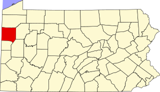
This is a list of the National Register of Historic Places listings in Mercer County, Pennsylvania.

<span class="mw-page-title-main">National Register of Historic Places listings in Mercer County, Kentucky</span>

This is a list of the National Register of Historic Places listings in Mercer County, Kentucky.

<span class="mw-page-title-main">National Register of Historic Places listings in Mercer County, West Virginia</span>

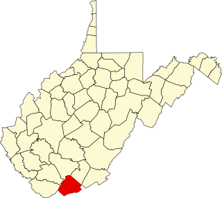
This is a list of the National Register of Historic Places listings in Mercer County, West Virginia.

<span class="mw-page-title-main">National Register of Historic Places listings in Hancock County, Ohio</span>

This is a list of the National Register of Historic Places listings in Hancock County, Ohio.

<span class="mw-page-title-main">National Register of Historic Places listings in Jackson County, Ohio</span>

This is a list of the National Register of Historic Places listings in Jackson County, Ohio.

<span class="mw-page-title-main">National Register of Historic Places listings in Wyandot County, Ohio</span>

This is a list of the National Register of Historic Places listings in Wyandot County, Ohio.

<span class="mw-page-title-main">National Register of Historic Places listings in Noble County, Ohio</span>

This is a list of the National Register of Historic Places listings in Noble County, Ohio.

<span class="mw-page-title-main">National Register of Historic Places listings in Meigs County, Ohio</span>

This is a list of the National Register of Historic Places listings in Meigs County, Ohio.

<span class="mw-page-title-main">National Register of Historic Places listings in Gallia County, Ohio</span>

This is a list of the National Register of Historic Places listings in Gallia County, Ohio.

<span class="mw-page-title-main">National Register of Historic Places listings in Van Wert County, Ohio</span>

This is a list of the National Register of Historic Places listings in Van Wert County, Ohio.

<span class="mw-page-title-main">National Register of Historic Places listings in Mercer County, Illinois</span>

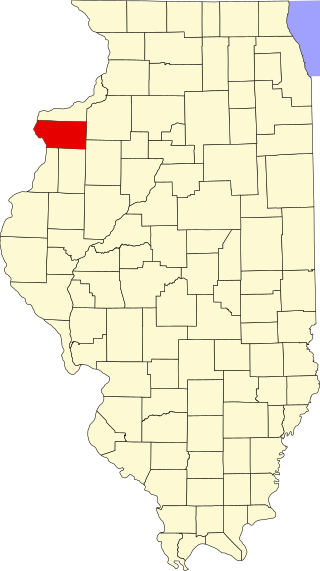
This is a list of the National Register of Historic Places listings in Mercer County, Illinois.

References

  1. The latitude and longitude information provided in this table was derived originally from the National Register Information System, which has been found to be fairly accurate for about 99% of listings. Some locations in this table may have been corrected to current GPS standards.
  2. National Park Service, United States Department of the Interior, "National Register of Historic Places: Weekly List Actions", retrieved January 19, 2024.
  3. Numbers represent an alphabetical ordering by significant words. Various colorings, defined here, differentiate National Historic Landmarks and historic districts from other NRHP buildings, structures, sites or objects.
  4. "National Register Information System". National Register of Historic Places . National Park Service. April 24, 2008.
  5. The eight-digit number below each date is the number assigned to each location in the National Register Information System database, which can be viewed by clicking the number.