St. Henry, Ohio

Last updated

St. Henry, Ohio
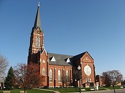
St. Henry Catholic Church side.jpg
St. Henry Catholic Church
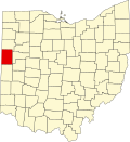
Mercer County Ohio incorporated and unincorporated areas St. Henry highlighted.svg
Location in Mercer County and the state of Ohio.
Coordinates: 40°25′23″N84°37′30″W / 40.42306°N 84.62500°W / 40.42306; -84.62500
Country United States
State Ohio
County Mercer
Township Granville
Area
[1]
  Total1.77 sq mi (4.59 km2)
  Land1.73 sq mi (4.47 km2)
  Water0.05 sq mi (0.12 km2)
Elevation
[2]
955 ft (291 m)
Population
 (2020)
  Total2,596
  Density1,504.93/sq mi (581.06/km2)
Time zone UTC-5 (Eastern (EST))
  Summer (DST) UTC-4 (EDT)
Area code 419
FIPS code 39-69540 [3]
GNIS feature ID2399173 [2]

St. Henry or Saint Henry [2] is a village in Mercer County, Ohio, United States. The population was 2,596 at the 2020 census.

Contents

History

St. Henry was laid out in 1837 by Johann Heinrich Römer (1805–1874). [4] It laid in a tract of land sold to him by his brother Franz on July 7, 1837. The tract was surveyed on July 7, the town was platted on July 13, and the plat was recorded on July 15. July 13 is the feast of St. Henry. [5] At the center of the village is St. Henry's Catholic Church. Completed in 1897, [6] the church is listed on the National Register of Historic Places. [7] A post office has been in operation at St. Henry since 1850. [8] The village was incorporated in 1901. [9]

Geography

According to the United States Census Bureau, the village has a total area of 1.65 square miles (4.27 km2), of which 1.60 square miles (4.14 km2) is land and 0.05 square miles (0.13 km2) is water. [10]

Demographics

Historical population
CensusPop.Note
1880 4
1890 21425.0%
1900 82290.5%
1910 14576.8%
1920 304109.7%
1930 42138.5%
1940 51422.1%
1950 61219.1%
1960 71116.2%
1970 84118.3%
1980 1,09630.3%
1990 1,32520.9%
2000 1,80436.2%
2010 2,42734.5%
2020 2,5967.0%
U.S. Decennial Census [11]
Religion in St. Henry[ citation needed ]
religionpercent
Roman Catholic
96.5%
Protestant
1.8%
No Religion
1.4%
"Unspecified"
.3%

According to the Census Bureau, as of 2015 [12] the median income for a household in the village was $80,000, and the median income for a family was $90,870. Males had a median income of $40,911 versus $27,102 for females. The per capita income for the village was $28,932. About 0.9% of families and 2.8% of the population were below the poverty line, including 2.0% of those under age 18 and 7.6% of those age 65 or over.

2010 census

As of the census [13] of 2010, there were 2,427 people, 862 households, and 646 families residing in the village. The population density was 1,516.9 inhabitants per square mile (585.7/km2). There were 892 housing units at an average density of 557.5 per square mile (215.3/km2). The racial makeup of the village was 99.1% White, 0.1% African American, 0.6% from other races, and 0.2% from two or more races. Hispanic or Latino of any race were 1.4% of the population.

There were 862 households, of which 36.5% had children under the age of 18 living with them, 67.3% were married couples living together, 5.2% had a female householder with no husband present, 2.4% had a male householder with no wife present, and 25.1% were non-families. 22.4% of all households were made up of individuals, and 12.6% had someone living alone who was 65 years of age or older. The average household size was 2.79 and the average family size was 3.33.

The median age in the village was 35.2 years. 29.5% of residents were under the age of 18; 8.3% were between the ages of 18 and 24; 22.6% were from 25 to 44; 23.8% were from 45 to 64; and 15.7% were 65 years of age or older. The gender makeup of the village was 50.0% male and 50.0% female.

Education

St. Henry contains one public high school, St. Henry High School. The St. Henry Redskins Football team has won state titles in 1990, 1992, 1994, 1995, 2004, and 2006 with two 2nd-place finishes in 1996 and 1999. St. Henry Football is tied with Versailles and their chief rival Coldwater for the second-most state championships (6) in Ohio (5 behind fellow MAC school Marion Local (Maria Stein) at 11) for a public school since the introduction of the current playoff system in 1972. St. Henry High School is part of the Midwest Athletic Conference.

St. Henry High School also holds seven girls volleyball state championships (2011, 2004, 1995, 1994, 1990, 1987, 1985), [14] four boys basketball state championships (1979, 1990, 1991, 2004), and three baseball state championships (1999, 2000, 2003).

St. Henry has a public library, a branch of the Mercer County District Library. [15]

Notable people

See also

Related Research Articles

<span class="mw-page-title-main">Mercer County, Ohio</span> County in Ohio, United States

Mercer County is located in the U.S. state of Ohio. As of the 2020 census, the population was 42,528. Its county seat is Celina. The county was created in 1820 and later organized in 1824. It is named for Hugh Mercer, an officer in the American Revolutionary War.

<span class="mw-page-title-main">Darke County, Ohio</span> County in Ohio, United States

Darke County is a county in the U.S. state of Ohio. As of the 2020 census, the population was 51,881. Its county seat and largest city is Greenville. The county was created in 1809 and later organized in 1817. It is named for William Darke, an officer in the American Revolutionary War. Darke County comprises the Greenville, OH Micropolitan Statistical Area, which is also included in the Dayton-Springfield-Sidney, OH Combined Statistical Area.

<span class="mw-page-title-main">Coldwater, Kansas</span> City in Comanche County, Kansas

Coldwater is a city and county seat of Comanche County, Kansas, United States. As of the 2020 census, the population of the city was 687.

<span class="mw-page-title-main">Coldwater Township, Branch County, Michigan</span> Civil township in Michigan, United States

Coldwater Township is a civil township of Branch County in the U.S. state of Michigan. The population was 3,406 at the 2020 census.

<span class="mw-page-title-main">Coldwater, Mississippi</span> Town in Mississippi, United States

Coldwater is a town in Tate County, Mississippi, United States, and is part of the Memphis Metropolitan Area. The population was 1,677 at the 2010 census.

<span class="mw-page-title-main">St. Marys, Ohio</span> City in Ohio, United States

St. Marys is a city in Auglaize County, Ohio, United States. Located in western Ohio, it is 11 miles (18 km) west of Wapakoneta and 20 miles (32 km) east of the Ohio–Indiana border. Founded in 1823, the city is located on a portage between the St. Marys and Auglaize river systems, which was a significant factor in its development before the era of canals. The population was 8,397 at the 2020 census. It is included in the Wapakoneta micropolitan area.

<span class="mw-page-title-main">Bridgeport, Ohio</span> Village in Ohio, United States

Bridgeport is a village in eastern Belmont County, Ohio, United States. It lies across the Ohio River from Wheeling, West Virginia, at the mouth of Wheeling Creek and is connected by two bridges to Wheeling Island. The population was 1,582 at the 2020 census. It is part of the Wheeling metropolitan area.

<span class="mw-page-title-main">Carrollton, Ohio</span> Village in Ohio, United States

Carrollton is a village in and the county seat of Carroll County, Ohio, located 22 miles (35 km) southeast of Canton. The population was 3,087 at the time of the 2020 census. It is part of the Canton–Massillon metropolitan area.

<span class="mw-page-title-main">Mingo Junction, Ohio</span> Village in Ohio, United States

Mingo Junction is a village in eastern Jefferson County, Ohio, United States, along the Ohio River. The population was 3,347 at the 2020 census. It is part of the Weirton–Steubenville metropolitan area.

<span class="mw-page-title-main">Celina, Ohio</span> City in Ohio, United States

Celina is a city in and the county seat of Mercer County, Ohio, United States about 58 miles (93 km) northwest of Dayton. The population was 10,935 at the 2020 census. Celina is situated on the northwestern shores of Grand Lake St. Marys.

<span class="mw-page-title-main">Coldwater, Ohio</span> Village in Ohio, United States

Coldwater is a village in Mercer County, Ohio, United States. The population was 4,774 at the 2020 census.

<span class="mw-page-title-main">Mendon, Ohio</span> Village in Ohio, United States

Mendon is a village in Mercer County, Ohio, United States. The population was 628 at the 2020 census.

<span class="mw-page-title-main">Montezuma, Ohio</span> Village in Ohio, United States

Montezuma is a village in Mercer County, Ohio, United States. The population was 152 at the 2020 census.

<span class="mw-page-title-main">Mantua, Ohio</span> Village in Ohio, United States

Mantua is a village in northern Portage County, Ohio, United States, along the Cuyahoga River. The population was 1,001 at the time of the 2020 census. It is part of the Akron metropolitan area. It was formed from portions of Mantua Township in the Connecticut Western Reserve.

<span class="mw-page-title-main">Fort Jennings, Ohio</span> Village in Ohio, United States

Fort Jennings is a village in the southwestern corner of Putnam County, Ohio, United States. The population was 525 at the 2020 census.

<span class="mw-page-title-main">Leipsic, Ohio</span> Village in Ohio, United States

Leipsic is a village in Putnam County, Ohio, United States. The population was 2,177 at the 2020 census.

<span class="mw-page-title-main">Dover, Ohio</span> City in Ohio, United States

Dover is a city in Tuscarawas County, Ohio, United States, along the Tuscarawas River. The population was 13,112 at the 2020 census. It is a principal city of the New Philadelphia–Dover micropolitan area, approximately 68 miles (109 km) south of Cleveland and borders the city of New Philadelphia.

<span class="mw-page-title-main">McArthur, Ohio</span> Village in Ohio, United States

McArthur is a village in and the county seat of Vinton County, Ohio, United States. It is located 27 miles (43 km) southeast of Chillicothe. The population was 1,783 at the 2020 census.

<span class="mw-page-title-main">Montpelier, Ohio</span> Village in Ohio, United States

Montpelier is a village in Williams County, Ohio, United States. The population was 3,942 at the 2020 census.

<span class="mw-page-title-main">Burkettsville, Ohio</span> Village in Ohio, United States

Burkettsville is a village in Darke and Mercer counties in the U.S. state of Ohio. The population was 272 at the 2020 census.

References

  1. "ArcGIS REST Services Directory". United States Census Bureau. Retrieved September 20, 2022.
  2. 1 2 3 U.S. Geological Survey Geographic Names Information System: St. Henry, Ohio
  3. "U.S. Census website". United States Census Bureau . Retrieved January 31, 2008.
  4. Scranton, S. S. (1907). History of Mercer County, Ohio, and Representative Citizens. Biographical Publishing Company. p.  196.
  5. Hoying, David A. "Cranberry Prairie". Die Deutsche Ecke. The German Corner (24).
  6. Brown, Mary Ann. Ohio Historic Inventory Nomination: St. Henry Catholic Church. Ohio Historical Society, n.d.
  7. "National Register Information System". National Register of Historic Places . National Park Service. March 13, 2009.
  8. "Mercer County". Jim Forte Postal History. Retrieved December 18, 2015.
  9. Scranton, S. S. (1907). History of Mercer County, Ohio, and Representative Citizens. Biographical Publishing Company. p.  197.
  10. "US Gazetteer files 2010". United States Census Bureau. Archived from the original on July 2, 2012. Retrieved January 6, 2013.
  11. "Census of Population and Housing". Census.gov. Retrieved June 4, 2015.
  12. "American FactFinder". United States Census Bureau. Archived from the original on February 13, 2020. Retrieved July 21, 2017.
  13. "U.S. Census website". United States Census Bureau . Retrieved January 6, 2013.
  14. "State Records: Volleyball". Ohio High School Athletic Association.
  15. "Hours and Locations". Mercer County District Library. Retrieved March 1, 2018.
  16. Wally Post still huge in tiny town, Cincinnati Enquirer

Further reading