Philothea is an unincorporated community in Mercer County, in the U.S. state of Ohio. [1]
Philothea is an unincorporated community in Mercer County, in the U.S. state of Ohio. [1]
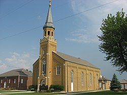
A post office called Philothea was established in 1886, and remained in operation until 1904. [2] Besides the post office, Philothea had a Catholic church and several stores. [3]
Municipalities and communities of Mercer County, Ohio, United States | ||
|---|---|---|
| City | 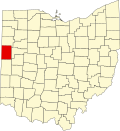 | |
| Villages | ||
| Townships | ||
| CDP | ||
| Other communities | ||
| Footnotes | ‡This populated place also has portions in an adjacent county or counties | |
40°27′02″N84°39′13″W / 40.45056°N 84.65361°W
| | This Mercer County, Ohio state location article is a stub. You can help Wikipedia by expanding it. |