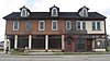
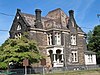
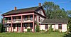
[3] Name on the Register [4] Image Date listed [5] Location City or town Description 1 Alliance Bank Building Alliance Bank Building July 28, 1995 (# 95000940 502 E. Main St. 40°55′19″N 81°05′54″W / 40.921883°N 81.098364°W / 40.921883; -81.098364 (Alliance Bank Building ) Alliance 2 Jacob H. Bair House Jacob H. Bair House December 29, 1978 (# 78002194 North of Canton at 7225 N. Market Ave. 40°53′13″N 81°21′52″W / 40.886944°N 81.364444°W / 40.886944; -81.364444 (Jacob H. Bair House ) Plain Township 3 Barber-Whitticar House Barber-Whitticar House July 15, 1982 (# 82003642 519 Cleveland Ave, SW. 40°47′45″N 81°22′41″W / 40.795833°N 81.378056°W / 40.795833; -81.378056 (Barber-Whitticar House ) Canton 4 Bender's Restaurant-Belmont Buffet Bender's Restaurant-Belmont Buffet July 21, 1987 (# 87001193 137 Court Ave., SW. 40°47′53″N 81°22′35″W / 40.798056°N 81.376389°W / 40.798056; -81.376389 (Bender's Restaurant-Belmont Buffet ) Canton 5 Bordner House Bordner House February 17, 1978 (# 78002191 4522 7th St., SW., west of Canton 40°47′40″N 81°25′43″W / 40.794444°N 81.428611°W / 40.794444; -81.428611 (Bordner House ) Perry Township 6 Brewster Railroad YMCA/Wandle House Brewster Railroad YMCA/Wandle House March 7, 1985 (# 85000486 45 S. Wabash Ave. 40°42′46″N 81°35′54″W / 40.712778°N 81.598333°W / 40.712778; -81.598333 (Brewster Railroad YMCA/Wandle House ) Brewster Railroad dormitory constructed in 1916 by the Wheeling and Lake Erie Railway (W&LE). The building now houses the Brewster-Sugarcreek Township Historical Society Museum and The Station Restaurant. [6] 7 Canal Fulton Historic District Canal Fulton Historic District December 2, 1982 (# 82001488 Ohio-Erie Canal, Market, Canal, Cherry and High Sts. 40°53′13″N 81°35′42″W / 40.886944°N 81.595°W / 40.886944; -81.595 (Canal Fulton Historic District ) Canal Fulton and Lawrence Township 8 Canton Public Library Canton Public Library July 15, 1982 (# 82003643 236 3rd St., SW. 40°47′50″N 81°22′37″W / 40.797222°N 81.376944°W / 40.797222; -81.376944 (Canton Public Library ) Canton 9 City National Bank Building City National Bank Building July 15, 1982 (# 82003644 205 Market Ave., S. 40°47′51″N 81°22′31″W / 40.7975°N 81.375278°W / 40.7975; -81.375278 (City National Bank Building ) Canton With Saxton House , part of the First Ladies National Historic Site ; also listed separately on the National Register. 10 City Savings Bank & Trust Company City Savings Bank & Trust Company September 2, 2016 (# 16000602 449 E. Main St. 40°55′18″N 81°05′56″W / 40.921771°N 81.098929°W / 40.921771; -81.098929 (City Savings Bank & Trust Company ) Alliance 11 Clearview Golf Club Clearview Golf Club February 16, 2001 (# 01000056 8410 Lincoln St., SE., southeast of East Canton 40°46′19″N 81°14′51″W / 40.771944°N 81.2475°W / 40.771944; -81.2475 (Clearview Golf Club ) Osnaburg Township The only golf club in the United States designed, built, owned and operated by an African American (William J. Powell). Opened for business in 1948, it is still owned and operated by the Powell family. [7] 12 George E. Cook House George E. Cook House May 2, 1995 (# 95000498 1435 Market Ave. N. 40°48′48″N 81°22′16″W / 40.813472°N 81.371111°W / 40.813472; -81.371111 (George E. Cook House ) Canton 13 Dewalt Building Dewalt Building July 15, 1982 (# 82003645 122 Market Ave., N. 40°47′57″N 81°22′30″W / 40.799167°N 81.375°W / 40.799167; -81.375 (Dewalt Building ) Canton 14 John and Syd Dobkins House John and Syd Dobkins House January 8, 2009 (# 08001298 5120 Plain Center, NE. 40°51′16″N 81°21′15″W / 40.854444°N 81.354167°W / 40.854444; -81.354167 (John and Syd Dobkins House ) Canton 15 Eagles Building-Strand Theater Eagles Building-Strand Theater January 25, 1997 (# 96001624 243 E. Main St. 40°55′18″N 81°06′10″W / 40.921667°N 81.102778°W / 40.921667; -81.102778 (Eagles Building-Strand Theater ) Alliance 16 Eagles' Temple Eagles' Temple July 15, 1982 (# 82003646 601 S. Market St. 40°47′41″N 81°22′32″W / 40.794722°N 81.375556°W / 40.794722; -81.375556 (Eagles' Temple ) Canton 17 Earley-Hartzell House Earley-Hartzell House December 21, 1987 (# 87002147 840 N. Park Ave. 40°55′49″N 81°06′17″W / 40.930278°N 81.104722°W / 40.930278; -81.104722 (Earley-Hartzell House ) Alliance Mabel Hartzell Historical Home at the Alliance Historical Society website. 18 East Main Street Historic District East Main Street Historic District September 8, 2017 (# 100001588 49-629 E. Main St., 40 N. Park, 77 S. Park, 532-570, 157 Prospect, 40 N.-136 S. Arch, 40 S. Linden Aves. 40°55′18″N 81°06′05″W / 40.921766°N 81.101397°W / 40.921766; -81.101397 (East Main Street Historic District ) Alliance 19 Elson-Magnolia Flour Mill Elson-Magnolia Flour Mill July 14, 2000 (# 00000800 261 N. Main St. 40°39′12″N 81°17′59″W / 40.653333°N 81.299722°W / 40.653333; -81.299722 (Elson-Magnolia Flour Mill ) Magnolia 20 Harry E. Fife House Harry E. Fife House July 21, 1987 (# 87001196 606 McKinley Ave. SW. 40°47′44″N 81°22′46″W / 40.795556°N 81.379444°W / 40.795556; -81.379444 (Harry E. Fife House ) Canton 21 Charles E. Firestone House Upload image June 21, 2011 (# 11000369 2814 Westdale Rd., NW 40°49′52″N 81°26′57″W / 40.831111°N 81.449167°W / 40.831111; -81.449167 (Charles E. Firestone House ) Jackson Township 22 First Ladies National Historic Site First Ladies National Historic Site January 31, 2001 (# 01000286 205 and 331 Market Avenue, S. 40°47′48″N 81°22′31″W / 40.796667°N 81.375278°W / 40.796667; -81.375278 (First Ladies National Historic Site ) Canton 23 First Methodist Episcopal Church First Methodist Episcopal Church April 16, 1979 (# 79001948 120 Cleveland Ave., SW. 40°47′54″N 81°22′35″W / 40.798333°N 81.376389°W / 40.798333; -81.376389 (First Methodist Episcopal Church ) Canton Home church of President William McKinley ; now known as Church of the Savior 24 First Methodist Episcopal Church First Methodist Episcopal Church August 22, 1985 (# 85001803 301 Lincoln Way E. 40°47′50″N 81°31′08″W / 40.797222°N 81.518889°W / 40.797222; -81.518889 (First Methodist Episcopal Church ) Massillon 25 First Methodist Episcopal Church of Alliance, Ohio First Methodist Episcopal Church of Alliance, Ohio May 2, 1985 (# 85000945 470 E. Broadway St. 40°55′10″N 81°05′58″W / 40.919444°N 81.099444°W / 40.919444; -81.099444 (First Methodist Episcopal Church of Alliance, Ohio ) Alliance 26 First National Bank Building First National Bank Building May 8, 1987 (# 87000689 11 Lincoln Way, W. 40°47′46″N 81°31′23″W / 40.796111°N 81.523056°W / 40.796111; -81.523056 (First National Bank Building ) Massillon 27 First Reformed and First Lutheran Churches First Reformed and First Lutheran Churches September 28, 1982 (# 82003647 901 and 909 E. Tuscarawas St. 40°47′51″N 81°22′03″W / 40.7975°N 81.3675°W / 40.7975; -81.3675 (First Reformed and First Lutheran Churches ) Canton First Reformed is now called First Church of the Resurrection 28 Five Oaks Five Oaks April 11, 1973 (# 73001535 210 4th St., NE. 40°47′58″N 81°31′07″W / 40.799444°N 81.518611°W / 40.799444; -81.518611 (Five Oaks ) Massillon 29 Fourth Street Historic District Fourth Street Historic District March 25, 1982 (# 82003654 Roughly bounded by 3rd, 5th and Cherry St. and Federal Ave. 40°48′04″N 81°31′11″W / 40.801111°N 81.519722°W / 40.801111; -81.519722 (Fourth Street Historic District ) Massillon 30 Frances Apartment Building Frances Apartment Building June 6, 1988 (# 88000668 534 Cleveland Ave., SW. 40°47′40″N 81°22′35″W / 40.794444°N 81.376389°W / 40.794444; -81.376389 (Frances Apartment Building ) Canton 31 Garnet B. French House Garnet B. French House October 31, 2002 (# 02001275 2410 Cleveland Ave. 40°49′26″N 81°23′01″W / 40.823889°N 81.383611°W / 40.823889; -81.383611 (Garnet B. French House ) Canton 32 Glamorgan Glamorgan October 5, 1972 (# 72001043 1025 S. Union Ave. 40°54′42″N 81°06′33″W / 40.911564°N 81.109122°W / 40.911564; -81.109122 (Glamorgan ) Alliance 33 Haines House Haines House July 30, 1974 (# 74001623 186 W. Market St. 40°55′15″N 81°06′42″W / 40.920833°N 81.111667°W / 40.920833; -81.111667 (Haines House ) Alliance Haines House website 34 Hartville Hotel Hartville Hotel January 3, 1980 (# 80003235 101 N. Prospect St. 40°57′51″N 81°19′51″W / 40.964167°N 81.330833°W / 40.964167; -81.330833 (Hartville Hotel ) Hartville Renovated in 2019 as The Pantry restaurant. Previously named the Hartville Pie Factory and Restaurant. 35 Harvard Company-Weber Dental Manufacturing Company Harvard Company-Weber Dental Manufacturing Company July 21, 1987 (# 87001194 2206 13th St. NE. 40°48′34″N 81°20′52″W / 40.809444°N 81.347778°W / 40.809444; -81.347778 (Harvard Company-Weber Dental Manufacturing Company ) Canton 36 Hercules Motors Corporation Industrial Complex Hercules Motors Corporation Industrial Complex June 10, 2005 (# 05000575 101 11th St. SE. 40°47′27″N 81°22′35″W / 40.790833°N 81.376389°W / 40.790833; -81.376389 (Hercules Motors Corporation Industrial Complex ) Canton 37 Hoover Company Historic District Hoover Company Historic District July 24, 2013 (# 13000538 101 E. Maple St. 40°52′35″N 81°24′05″W / 40.876389°N 81.401389°W / 40.876389; -81.401389 (Hoover Company Historic District ) North Canton 38 Hoover Farm Hoover Farm August 3, 1979 (# 79001955 East of central North Canton on Easton St. 40°52′32″N 81°22′12″W / 40.875556°N 81.370000°W / 40.875556; -81.370000 (Hoover Farm ) North Canton Also known as the Hoover Historical Center [4] 39 Ideal Department Store Building Ideal Department Store Building September 10, 1992 (# 92001245 55-59 Lincoln Way E. 40°47′47″N 81°31′20″W / 40.796389°N 81.522222°W / 40.796389; -81.522222 (Ideal Department Store Building ) Massillon 40 Lake Township School Lake Township School June 22, 1976 (# 76001528 East of Uniontown at 1101 Lake Center St. 40°57′32″N 81°21′42″W / 40.958889°N 81.361667°W / 40.958889; -81.361667 (Lake Township School ) Lake Township One room schoolhouse established circa 1850 [8] 41 Landmark Tavern Landmark Tavern March 12, 1982 (# 82003648 501 E. Tuscarawas St. 40°47′52″N 81°22′15″W / 40.797778°N 81.370833°W / 40.797778; -81.370833 (Landmark Tavern ) Canton 42 Carl and Audrey Lavin House Upload image August 31, 2018 (# 100002880 5240 Plain Center Ave., NE. 40°51′24″N 81°21′18″W / 40.8567°N 81.3551°W / 40.8567; -81.3551 (Carl and Audrey Lavin House ) Canton 43 John H. Lehman High School John H. Lehman High School August 24, 2017 (# 100001508 1120 15th St. NW. 40°48′51″N 81°22′59″W / 40.814047°N 81.383114°W / 40.814047; -81.383114 (John H. Lehman High School ) Canton 44 Loew-Define Grocery Store and Home Loew-Define Grocery Store and Home November 29, 1979 (# 79001954 202 S. Market St. 40°43′20″N 81°31′05″W / 40.722222°N 81.518056°W / 40.722222; -81.518056 (Loew-Define Grocery Store and Home ) Navarre Home of Justice of the Peace John Loew; site of President William McKinley 's first law trial in 1867. 45 Louisville Historic District Louisville Historic District November 22, 2011 (# 11000856 Roughly bounded by Chapel, Lincoln, St. Louis Ct., Nickel Plate, E. Gorgas, and Center Ct. 40°50′15″N 81°15′34″W / 40.837578°N 81.259556°W / 40.837578; -81.259556 (Louisville Historic District ) Louisville 46 Brooke and Anna E. Martin House Brooke and Anna E. Martin House January 21, 1999 (# 98001642 1627 Market Ave. N. 40°48′57″N 81°22′11″W / 40.815833°N 81.369722°W / 40.815833; -81.369722 (Brooke and Anna E. Martin House ) Canton 47 Massillon Cemetery Building Massillon Cemetery Building March 12, 1982 (# 82003655 1827 Erie St. S. 40°46′35″N 81°30′55″W / 40.776389°N 81.515278°W / 40.776389; -81.515278 (Massillon Cemetery Building ) Massillon 48 Massillon Downtown Historic District Massillon Downtown Historic District June 8, 2018 (# 100002553 Roughly bounded by 1st and 3rd Sts. and Tremont and Federal Aves. 40°47′51″N 81°31′13″W / 40.797392°N 81.520239°W / 40.797392; -81.520239 (Massillon Downtown Historic District ) Massillon 49 Maudru House Maudru House November 25, 1980 (# 80003234 11786 Easton St. in Maximo [9] 40°52′28″N 81°10′36″W / 40.874444°N 81.176667°W / 40.874444; -81.176667 (Maudru House ) Washington Township Maximo's only brick house [10] 50 William McKinley Tomb William McKinley Tomb November 10, 1970 (# 70000516 7th St., NW. 40°48′24″N 81°23′33″W / 40.8067°N 81.3925°W / 40.8067; -81.3925 (William McKinley Tomb ) Canton 51 McKinley Park Apartments Upload image January 21, 2021 (# 100006041 510 High Ave. SW 40°48′09″N 81°22′45″W / 40.8025°N 81.3793°W / 40.8025; -81.3793 (McKinley Park Apartments ) Canton 52 Mellett-Canton Daily News Building Mellett-Canton Daily News Building April 21, 1983 (# 83002058 401 W. Tuscarawas St. 40°47′57″N 81°22′35″W / 40.799167°N 81.376389°W / 40.799167; -81.376389 (Mellett-Canton Daily News Building ) Canton 53 John Miller House John Miller House July 22, 1994 (# 94000775 9677 Cleveland Ave., NW., in Greentown 40°55′37″N 81°24′11″W / 40.926944°N 81.403056°W / 40.926944; -81.403056 (John Miller House ) Lake Township 54 Mount Union College District Mount Union College District October 5, 1972 (# 72001044 Hartshorn St., Miller and Aultman Aves. 40°54′12″N 81°06′34″W / 40.903333°N 81.109444°W / 40.903333; -81.109444 (Mount Union College District ) Alliance 55 New Baltimore Inn New Baltimore Inn December 18, 1975 (# 75001535 14722 Ravenna Ave. in New Baltimore 40°59′04″N 81°14′57″W / 40.984444°N 81.249167°W / 40.984444; -81.249167 (New Baltimore Inn ) Marlboro Township 56 Old McKinley High School Old McKinley High School June 30, 1982 (# 82003649 800 N. Market St. 40°48′13″N 81°22′20″W / 40.803611°N 81.372222°W / 40.803611; -81.372222 (Old McKinley High School ) Canton 57 Onesto Hotel Onesto Hotel July 15, 1982 (# 82003650 2nd and Cleveland, NW. 40°47′56″N 81°22′30″W / 40.798889°N 81.375°W / 40.798889; -81.375 (Onesto Hotel ) Canton 58 Palace Theater Palace Theater April 26, 1979 (# 79001949 605 Market Ave., N. 40°48′07″N 81°22′27″W / 40.801944°N 81.374167°W / 40.801944; -81.374167 (Palace Theater ) Canton 59 Portage Street Elementary School Upload image August 22, 2022 (# 100008013 239 and 301 Portage St. 40°52′37″N 81°24′15″W / 40.8769°N 81.4042°W / 40.8769; -81.4042 (Portage Street Elementary School ) North Canton 60 Robert A. and Elizabeth H. Purcell House Robert A. and Elizabeth H. Purcell House October 13, 2004 (# 04001146 2700 Fairway Ln. 40°53′42″N 81°05′33″W / 40.895000°N 81.092500°W / 40.895000; -81.092500 (Robert A. and Elizabeth H. Purcell House ) Alliance 61 Walter S. Putman House Walter S. Putman House September 10, 1992 (# 92001247 303 Lawnford Ave. 40°39′18″N 81°38′17″W / 40.655°N 81.638056°W / 40.655; -81.638056 (Walter S. Putman House ) Wilmot 62 Harry S. Renkert House Harry S. Renkert House June 18, 1981 (# 81000451 1414 Market Ave., N. 40°48′46″N 81°22′14″W / 40.812889°N 81.370453°W / 40.812889; -81.370453 (Harry S. Renkert House ) Canton Now houses the Greater Canton Amateur Sports Hall of Fame [11] 63 Ridgewood Historic District Ridgewood Historic District December 19, 1982 (# 82001489 Bounded by Gibbs Ave., Frazer Ave., 25th St., and 19th St. 40°49′18″N 81°22′14″W / 40.8217°N 81.3706°W / 40.8217; -81.3706 (Ridgewood Historic District ) Canton 64 Rochester Square Historic District Rochester Square Historic District October 26, 2005 (# 05001187 6 & 10 Lintner Ct. NW; 14, 207, 212, 222, 228, and 232 Center St. W. 40°43′15″N 81°31′37″W / 40.7208°N 81.5269°W / 40.7208; -81.5269 (Rochester Square Historic District ) Navarre 65 St. Edward Hotel St. Edward Hotel May 2, 2005 (# 05000024 400 Market Ave. N. 40°48′02″N 81°22′26″W / 40.8006°N 81.3739°W / 40.8006; -81.3739 (St. Edward Hotel ) Canton 66 St. John's Catholic Church St. John's Catholic Church May 27, 1975 (# 75001533 6th St. and McKinley Ave., NW. 40°48′11″N 81°22′39″W / 40.8031°N 81.3775°W / 40.8031; -81.3775 (St. John's Catholic Church ) Canton named a Minor basilica by Holy See in 2012 67 St. Joseph Roman Catholic Church Complex Upload image November 19, 2020 (# 100005806 2427 Tuscarawas St. West 40°47′57″N 81°24′08″W / 40.7993°N 81.4022°W / 40.7993; -81.4022 (St. Joseph Roman Catholic Church Complex ) Canton 68 Saint Joseph's Roman Catholic Church Saint Joseph's Roman Catholic Church May 21, 2010 (# 10000279 322 3rd St. SE 40°47′40″N 81°31′03″W / 40.7945°N 81.5174°W / 40.7945; -81.5174 (Saint Joseph's Roman Catholic Church ) Massillon 69 St. Louis Church St. Louis Church February 22, 1979 (# 79001951 300 N. Chapel St. 40°50′20″N 81°15′33″W / 40.8389°N 81.2592°W / 40.8389; -81.2592 (St. Louis Church ) Louisville 70 St. Mary's Catholic Church St. Mary's Catholic Church April 16, 1979 (# 79001952 206 Cherry Rd., NE. 40°48′08″N 81°31′22″W / 40.8022°N 81.5228°W / 40.8022; -81.5228 (St. Mary's Catholic Church ) Massillon 71 St. Paul's Reformed Church St. Paul's Reformed Church April 26, 2006 (# 06000318 9669 Erie Ave., SW., south of Navarre 40°40′22″N 81°32′20″W / 40.6728°N 81.5389°W / 40.6728; -81.5389 (St. Paul's Reformed Church ) Bethlehem Township In 2008, was known as St. Paul's Community Church and had only one remaining active member. [12] 72 St. Peter Church St. Peter Church March 22, 1990 (# 90000472 720 Cleveland Ave., NW. 40°48′14″N 81°22′29″W / 40.8039°N 81.3747°W / 40.8039; -81.3747 (St. Peter Church ) Canton 73 St. Timothy's Protestant Episcopal Church St. Timothy's Protestant Episcopal Church February 22, 1979 (# 79001953 226 SE. 3rd St. 40°47′44″N 81°31′04″W / 40.7956°N 81.5178°W / 40.7956; -81.5178 (St. Timothy's Protestant Episcopal Church ) Massillon 74 Saxton House Saxton House April 26, 1979 (# 79001950 331 S. Market St. 40°47′47″N 81°22′33″W / 40.7964°N 81.3758°W / 40.7964; -81.3758 (Saxton House ) Canton 75 August Schuffenecker Building August Schuffenecker Building September 2, 1982 (# 82003651 134 6th St. SW. 40°47′41″N 81°22′34″W / 40.7947°N 81.3761°W / 40.7947; -81.3761 (August Schuffenecker Building ) Canton 76 Science Hill School Science Hill School July 22, 1994 (# 94000776 11810 Beeson St., west of Alliance 40°55′24″N 81°10′26″W / 40.9233°N 81.1739°W / 40.9233; -81.1739 (Science Hill School ) Lexington Township One-room schoolhouse built circa 1870 operated continuously from 1884 to 1956; the last one-room school in Stark County. [13] 77 Emanuel and Frederick Serquet Farm Emanuel and Frederick Serquet Farm December 2, 1982 (# 82001490 North of Wilmot at 14091 Stoneford 40°40′52″N 81°37′42″W / 40.6811°N 81.6283°W / 40.6811; -81.6283 (Emanuel and Frederick Serquet Farm ) Sugar Creek Township 78 Seven Ranges Terminus Seven Ranges Terminus December 12, 1976 (# 76001527 West of Magnolia at the junction of Stark, Tuscarawas, and Carroll counties 40°39′07″N 81°19′05″W / 40.6519°N 81.3181°W / 40.6519; -81.3181 (Seven Ranges Terminus ) Pike and Sandy Townships Extends into Carroll and Tuscarawas counties 79 Spring Hill Spring Hill April 14, 1972 (# 72001045 Wales Rd., NE. 40°48′45″N 81°30′23″W / 40.8124°N 81.5063°W / 40.8124; -81.5063 (Spring Hill ) Massillon 80 Stahl-Hoagland House Stahl-Hoagland House February 6, 1997 (# 96001621 330 W. Wooster St. 40°43′29″N 81°31′43″W / 40.7247°N 81.5286°W / 40.7247; -81.5286 (Stahl-Hoagland House ) Navarre Built in 1834 by Ohio and Erie Canal boat captain William Stahl. Purchased in 1881 by Marquis L. Hoagland, another canal worker. Now owned by the son of Hoagland's youngest daughter. [14] 81 Stark County Courthouse and Annex Stark County Courthouse and Annex April 3, 1975 (# 75001534 Market and Tuscarawas Sts. 40°47′56″N 81°22′31″W / 40.7989°N 81.3753°W / 40.7989; -81.3753 (Stark County Courthouse and Annex ) Canton 82 Harry Bartlett Stewart Property Harry Bartlett Stewart Property April 29, 1982 (# 82003653 13480 Congress Lake Rd., northeast of Hartville 40°58′46″N 81°18′17″W / 40.9794°N 81.3047°W / 40.9794; -81.3047 (Harry Bartlett Stewart Property ) Lake Township 83 Timken Vocational High School Timken Vocational High School December 7, 2018 (# 100003211 521 Tuscarawas St., W. 40°47′57″N 81°22′44″W / 40.7993°N 81.3788°W / 40.7993; -81.3788 (Timken Vocational High School ) Canton 84 Henry H. Timken Estate Barn Henry H. Timken Estate Barn December 29, 1978 (# 78002193 13th St., NW. and Interstate 77 40°48′42″N 81°23′57″W / 40.8117°N 81.3993°W / 40.8117; -81.3993 (Henry H. Timken Estate Barn ) Canton 85 The Town Pump of East Sparta The Town Pump of East Sparta April 1, 2009 (# 09000172 Junction of Walnut Street and Main Avenue 40°40′00″N 81°21′12″W / 40.6667°N 81.3532°W / 40.6667; -81.3532 (The Town Pump of East Sparta ) East Sparta 86 Trinity Lutheran Church Trinity Lutheran Church August 23, 1985 (# 85001802 415 W. Tuscarawas St. 40°47′58″N 81°22′40″W / 40.7994°N 81.3778°W / 40.7994; -81.3778 (Trinity Lutheran Church ) Canton 87 Upper Downtown Canton Historic District Upper Downtown Canton Historic District June 7, 2006 (# 06000202 Market Ave., between Sixth St. N. and 2nd St. S., east to west variable boundary 40°48′06″N 81°22′32″W / 40.8017°N 81.3756°W / 40.8017; -81.3756 (Upper Downtown Canton Historic District ) Canton 88 Vicary House Vicary House March 15, 1982 (# 82003652 3730 Market Ave. N. 40°50′21″N 81°21′52″W / 40.8392°N 81.3644°W / 40.8392; -81.3644 (Vicary House ) Canton 89 Werner Inn Werner Inn September 17, 1987 (# 87001635 131 E. Nassau St. 40°47′15″N 81°17′00″W / 40.7875°N 81.2833°W / 40.7875; -81.2833 (Werner Inn ) East Canton 90 Wilmot United Brethren Church Wilmot United Brethren Church June 22, 1976 (# 76001529 Massillon St. (U.S. Route 62 ) 40°39′24″N 81°37′55″W / 40.6567°N 81.6319°W / 40.6567; -81.6319 (Wilmot United Brethren Church ) Wilmot