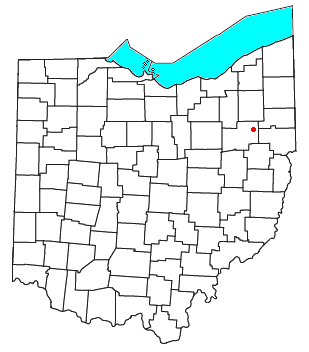


Maximo is an unincorporated community in northwestern Washington Township, Stark County, Ohio, United States. [1] It has a post office with the ZIP code 44650. [2] The community is part of the Canton – Massillon Metropolitan Statistical Area.
Maximo is an unincorporated community in northwestern Washington Township, Stark County, Ohio, United States. [1] It has a post office with the ZIP code 44650. [2] The community is part of the Canton – Massillon Metropolitan Statistical Area.
Maximo was originally called Strasburg, and under the latter name was platted in 1842. [3] Maximo's name is derived from the fact that it was a high point on the Pittsburgh-Fort Wayne rail line. A post office called Maximo has been in operation since 1853. [4]

New Rumley is an unincorporated community in central Rumley Township, Harrison County, Ohio, United States. It is famous for being the birthplace of George Armstrong Custer.

Sulphur Springs is a census-designated place (CDP) in eastern Liberty Township, Crawford County, Ohio, United States. As of the 2020 census it had a population of 197. It has a post office with the ZIP code 44881. It is located along State Route 98 northeast of the city of Bucyrus, the county seat of Crawford County.
Warnock is an unincorporated community in northern Smith Township, Belmont County, Ohio, United States. It has a post office with the ZIP code 43967. It lies along State Route 9.

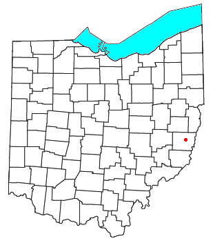
Piedmont is an unincorporated community in western Moorefield Township, Harrison County, Ohio, United States. It has a post office with the ZIP code 43983.

North Benton is an unincorporated community in northern Smith Township, Mahoning County, Ohio, United States. It has a post office with the ZIP code 44449. It lies along State Route 14 between Salem and Ravenna.

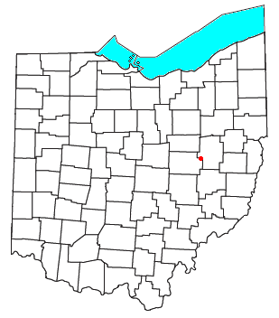
Keene is an unincorporated community in central Keene Township, Coshocton County, Ohio, United States. It has a post office with the ZIP code 43828.

Blissfield is an unincorporated community in southwestern Clark Township, Coshocton County, Ohio, United States. It has a post office with the ZIP code 43805. It lies along State Route 60 between Warsaw and Killbuck.
Bakersville is an unincorporated community in northeastern Adams Township, Coshocton County, Ohio, United States. It has a post office with the ZIP code 43803. It lies along State Route 751 northeast of West Lafayette.

Harlem Springs is an unincorporated community in central Lee Township, Carroll County, Ohio, United States. It has a post office with the ZIP code 44631. It lies along State Route 43. The community is part of the Canton–Massillon Metropolitan Statistical Area.

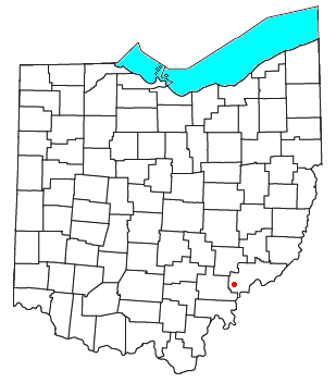
Somerdale is an unincorporated community in northeastern Fairfield Township, Tuscarawas County, Ohio, United States. It has a post office with the ZIP code 44678. It lies along State Route 212, Conotton Creek and the Wheeling and Lake Erie Railway east of Zoar.

Stillwater is an unincorporated community in eastern Rush Township, Tuscarawas County, Ohio, United States. It has a post office with the ZIP code 44679. It lies at the intersection of State Routes 258 and 800.

Paris is an unincorporated community in northwestern Paris Township, Stark County, Ohio. It has a post office with the ZIP code 44669. It lies along State Route 172 between East Canton and Lisbon. The community is part of the Canton–Massillon Metropolitan Statistical Area.

Wingett Run is an unincorporated community in western Ludlow Township, Washington County, Ohio, United States. It has a post office with the ZIP code 45789. It is located along State Route 26 and the Little Muskingum River.

Whipple is an unincorporated community in southern Salem Township, Washington County, Ohio, United States. Although it is unincorporated, it once had a post office, with the ZIP code 45788. It lies on State Route 821 south of the village of Lower Salem, at the junction of Whipple Run with Duck Creek. The community took its name from nearby Whipple Run.
Cutler is an unincorporated community in southwestern Fairfield Township, Washington County, Ohio, United States. It has a post office with the ZIP code 45724. It lies at the intersection of State Route 555 and County Road 59 near Gilbert Run, a subsidiary of the Little Hocking River, which meets the Ohio River at Little Hocking to the southeast.

Bartlett is an unincorporated community in southwestern Wesley Township, Washington County, Ohio, United States. It has a post office with the ZIP code 45713. It sits at the intersection of State Routes 550 and 555 near Coal Run, a subsidiary of Wolf Creek, which meets the Muskingum River at Waterford to the north. Near Bartlett is located the Shinn Covered Bridge, which spans Wolf Creek.

Chandlersville is an unincorporated community in western Salt Creek Township, Muskingum County, Ohio, United States. It has a post office with the ZIP code 43727. It lies along State Route 146 at its intersection with State Routes 284 and 313.

Petersburg, sometimes spelled "Petersburgh", is an unincorporated community in Union Township, Carroll County, Ohio, United States. The community is part of the Canton–Massillon Metropolitan Statistical Area. The community is served by the Carrollton post office, ZIP code 44615. It is located on the North Fork McGuire Creek and State Route 332.

New Cumberland is an unincorporated community in Warren Township, Tuscarawas County, Ohio, United States. The community is served by the Mineral City, Ohio post office, ZIP code 44656. It is located on Conotton Creek, State Route 212 and the Wheeling and Lake Erie Railway.

Conotton is an unincorporated community in North Township, Harrison County, Ohio, United States. The community is serviced by the Bowerston post office, ZIP Code 44695. It is located near Conotton Creek, State Route 151 and the Wheeling and Lake Erie Railway. According to the GNIS the community has also been known as Masterville.
Municipalities and communities of Stark County, Ohio, United States | ||
|---|---|---|
| Cities |  | |
| Villages | ||
| Townships | ||
| CDPs | ||
| Unincorporated communities | ||
| Footnotes | ‡This populated place also has portions in an adjacent county or counties | |
40°52′35″N81°10′19″W / 40.87639°N 81.17194°W
| | This Stark County, Ohio state location article is a stub. You can help Wikipedia by expanding it. |