
Taft Heights is a census-designated place (CDP) in Kern County, California, United States. Taft Heights is located 1 mile (1.6 km) west-southwest of Taft, at an elevation of 1,178 feet (359 m). The population was 1,949 at the 2010 census, up from 1,865 at the 2000 census.
Bret Harte is a census-designated place (CDP) in Stanislaus County, California, United States. The population was 5,152 at the 2010 census, down from 5,161 at the 2000 census. It is part of the Modesto Metropolitan Statistical Area. It is named for the American poet and short story writer, Bret Harte, best known for his writings about the California Gold Rush.

Harlem Heights is an unincorporated community and census-designated place (CDP) in Lee County, Florida, United States. The population was 1,930 at the 2020 census, down from 1,975 at the 2010 census. It is part of the Cape Coral-Fort Myers, Florida Metropolitan Statistical Area.

Preston Heights is an unincorporated community and census-designated place (CDP) in Will County, Illinois, United States. As of the 2020 census, the CDP population was 2,898.

Benton Heights is an unincorporated community in Berrien County in the U.S. state of Michigan. It is also a census-designated place (CDP) for statistical purposes without any legal status as an incorporated municipality. Per the 2020 Census, the population was 3,652. The community is a part of Benton Charter Township and is adjacent to the city of Benton Harbor.

Lewistown Heights is an unincorporated area and census-designated place (CDP) in Fergus County, Montana, United States. The population was 407 at the 2010 census, up from 365 in 2000.

Holiday Heights is an unincorporated community and census-designated place (CDP) located within Berkeley Township, in Ocean County, in the U.S. state of New Jersey. As of the 2010 United States Census, the CDP's population was 2,099.

Billington Heights is a hamlet and census-designated place (CDP) in the towns of Elma and Aurora in Erie County, New York, United States. The population was 1,685 at the 2010 census. It is part of the Buffalo–Niagara Falls Metropolitan Statistical Area.

Washington Heights is a census-designated place (CDP) in Orange County, New York, United States. The population was 2,205 at the 2020 census.

Shelter Island Heights is a hamlet and census-designated place (CDP) located in the Town of Shelter Island, in Suffolk County, New York, United States. It is located on the north side of Shelter Island, surrounding the village of Dering Harbor. The population was 1,601 at the time of the 2020 census.

Day Heights is a census-designated place (CDP) in Miami Township, Clermont County, Ohio, United States. The population was 2,625 at the 2020 census.

Lenape Heights is a census-designated place (CDP) in Armstrong County, Pennsylvania, United States. The population was 1,144 at the 2020 census.
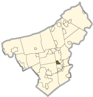
Palmer Heights is a census-designated place (CDP) in the Town of Palmer, Pennsylvania. The population of Palmer Heights was 3,762 at the 2010 census. Palmer Heights is part of the Lehigh Valley, which had a population of 861,899 and was the 68th-most populous metropolitan area in the U.S. as of the 2020 census.
Shenandoah Heights is a census-designated place (CDP) in Schuylkill County, Pennsylvania. The population was 1,298 at the 2000 census.
Woodland Heights is a census-designated place (CDP) in Venango County, Pennsylvania, United States. The population was 1,402 at the 2000 census.
Lawson Heights is a census-designated place (CDP) in Unity Township, Westmoreland County, Pennsylvania, United States. The population was 2,339 at the 2000 census.

Ashland Heights is a census-designated place (CDP) and unincorporated community in Pennington County, South Dakota, United States. The population was 678 at the 2020 census.
Colonial Heights is a census-designated place (CDP) in Sullivan County, Tennessee, United States. It is located within the city of Kingsport.

Longview Heights is a census-designated place (CDP) in Cowlitz County, Washington, United States. The population was 4,033 at the 2020 Census. The CDP is known locally as Columbia Heights.

Arlington Heights is a census-designated place (CDP) in Snohomish County, Washington, United States. As of the 2020 census, the population was 2,477, up from 2,284 at the 2010 census.


