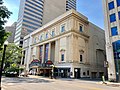
[ 2] Name on the Register [ 3] Image Date listed [ 4] Location CRHP -listed Description 1 # American Insurance Union Citadel American Insurance Union Citadel March 21, 1975 (#75001398 ) 50 W. Broad St. 39°57′44.550″N 83°0′7.513″W / 39.96237500°N 83.00208694°W / 39.96237500; -83.00208694 (American Insurance Union Citadel ) Yes Now known as the LeVeque Tower and Palace Theatre 2 # Athletic Club of Columbus Athletic Club of Columbus September 29, 2011 (# 11000711 136 E. Broad St. 39°57′47″N 82°59′49″W / 39.96306°N 82.99694°W / 39.96306; -82.99694 (Athletic Club of Columbus ) No 3 # Beatty-Moore House Upload image February 17, 2023 (# 100008631 41 North Monroe Ave. 39°57′57″N 82°58′43″W / 39.9658°N 82.9787°W / 39.9658; -82.9787 (Beatty-Moore House ) No 4 # Bellows Avenue School Upload image January 11, 2024 (# 100009450 725 Bellows Ave. 39°57′10″N 83°01′06″W / 39.9529°N 83.01836°W / 39.9529; -83.01836 (Bellows Avenue School ) No 5 # Berry Brothers Bolt Works Berry Brothers Bolt Works February 19, 1988 (# 88000051 350 E. 1st Ave. 39°58′51.701″N 82°59′40.805″W / 39.98102806°N 82.99466806°W / 39.98102806; -82.99466806 (Berry Brothers Bolt Works ) No 6 # Richard Berry Jr. House Richard Berry Jr. House July 27, 2005 (# 05000754 324 E. North Broadway 40°1′54.8″N 83°0′23.7″W / 40.031889°N 83.006583°W / 40.031889; -83.006583 (Richard Berry Jr. House ) Yes 7 # Born Capital Brewery Bottling Works Born Capital Brewery Bottling Works June 18, 2009 (# 09000442 570 S. Front St. 39°57′0.50″N 82°59′59.28″W / 39.9501389°N 82.9998000°W / 39.9501389; -82.9998000 (Born Capital Brewery Bottling Works ) No 8 # Bradford Shoe Company Building Bradford Shoe Company Building July 22, 1994 (# 94000772 232 Neilston St. 39°58′4.73″N 82°59′39.05″W / 39.9679806°N 82.9941806°W / 39.9679806; -82.9941806 (Bradford Shoe Company Building ) No 9 # Broad Street Apartments Broad Street Apartments December 16, 1986 (# 86003404 880-886 E. Broad St. 39°58′3″N 82°58′56″W / 39.96750°N 82.98222°W / 39.96750; -82.98222 (Broad Street Apartments ) Yes 10 # Broad Street Christian Church Broad Street Christian Church December 16, 1986 (# 86003448 1051 E. Broad St. 39°57′54″N 82°58′23″W / 39.96500°N 82.97306°W / 39.96500; -82.97306 (Broad Street Christian Church ) Yes 11 # Broad Street United Methodist Church Broad Street United Methodist Church November 26, 1980 (# 80002997 501 E. Broad St. 39°57′47.9″N 82°59′15.0″W / 39.963306°N 82.987500°W / 39.963306; -82.987500 (Broad Street United Methodist Church ) Yes 12 # Buckeye State Building and Loan Company Building Buckeye State Building and Loan Company Building October 13, 2004 (# 04001145 36-42 E. Gay St. 39°57′50.8″N 82°59′59.1″W / 39.964111°N 82.999750°W / 39.964111; -82.999750 (Buckeye State Building and Loan Company Building ) No 13 # Budd Dairy Company Budd Dairy Company February 14, 2017 (# 100000664 1086 N. 4th St. 39°59′6.749″N 82°59′55.648″W / 39.98520806°N 82.99879111°W / 39.98520806; -82.99879111 (Budd Dairy Company ) No 14 # Cambridge Arms Cambridge Arms December 18, 2003 (# 86003412 926 E. Broad St. 39°57′55″N 82°58′34″W / 39.965395°N 82.976118°W / 39.965395; -82.976118 (Cambridge Arms ) Yes 15 # Camp Chase Site Camp Chase Site April 11, 1973 (# 73001434 2900 Sullivant Ave. 39°56′38″N 83°04′33″W / 39.943889°N 83.075833°W / 39.943889; -83.075833 (Camp Chase Site ) No 16 # Shrum Mound Shrum Mound November 10, 1970 (# 70000490 McKinley Ave. 39°59′24″N 83°04′51″W / 39.99°N 83.080833°W / 39.99; -83.080833 (Shrum Mound ) No 17 # Central Assurance Company Central Assurance Company December 19, 1986 (# 86003421 741 E. Broad St. 39°57′51″N 82°58′52″W / 39.964167°N 82.981111°W / 39.964167; -82.981111 (Central Assurance Company ) No 18 # Central Building of the Columbus Young Men's Christian Association Central Building of the Columbus Young Men's Christian Association May 6, 1993 (# 93000402 40 W. Long St. 39°57′54″N 83°00′09″W / 39.965°N 83.0025°W / 39.965; -83.0025 (Central Building of the Columbus Young Men's Christian Association ) No 19 # Central High School Central High School March 7, 1985 (# 85000484 75 S. Washington Boulevard 39°57′35″N 83°00′23″W / 39.959722°N 83.006389°W / 39.959722; -83.006389 (Central High School ) Yes Now houses the COSI museum 20 # Central Ohio Lunatic Asylum Central Ohio Lunatic Asylum April 24, 1986 (# 86000851 1960 W. Broad St. 39°57′30″N 83°03′20″W / 39.958333°N 83.055556°W / 39.958333; -83.055556 (Central Ohio Lunatic Asylum ) No Demolished 21 # Coe Mound Upload image July 18, 1974 (# 74001486 West of High Street [ 5] No Site and its coordinates are restricted 22 # Truman and Sylvia Bull Coe House Truman and Sylvia Bull Coe House May 10, 2006 (# 06000361 75 E. Lakeview Ave. 40°01′38″N 83°00′44″W / 40.027150°N 83.012337°W / 40.027150; -83.012337 (Truman and Sylvia Bull Coe House ) No 23 # Columbia Building Columbia Building August 12, 1983 (# 83001967 161-167 N. High St. 39°57′57″N 83°00′06″W / 39.965702°N 83.001729°W / 39.965702; -83.001729 (Columbia Building ) Yes 24 # Columbus Center Columbus Center March 10, 2023 (# 100008685 100 East Broad St. 39°57′47.05″N 82°59′51.40″W / 39.9630694°N 82.9976111°W / 39.9630694; -82.9976111 (Columbus Center ) No Now known as Chase Tower 25 # Columbus Carriage Manufacturing Co. - Seagrave Co. Buildings Upload image March 18, 2024 (# 100010052 2000-2050 S. High St. 39°55′12″N 82°59′43″W / 39.9199°N 82.9953°W / 39.9199; -82.9953 (Columbus Carriage Manufacturing Co. - Seagrave Co. Buildings ) No 26 # Columbus Country Club Mound Columbus Country Club Mound February 15, 1974 (# 74001487 4831 E. Broad St. [ 5] 39°58′09″N 82°51′41″W / 39.969167°N 82.861389°W / 39.969167; -82.861389 (Columbus Country Club Mound ) No 27 # Columbus Gallery of Fine Arts Columbus Gallery of Fine Arts March 19, 1992 (# 92000173 480 E. Broad St. 39°57′51″N 82°59′16″W / 39.964167°N 82.987778°W / 39.964167; -82.987778 (Columbus Gallery of Fine Arts ) No 28 † Columbus Near East Side District Columbus Near East Side District May 19, 1978 (# 78002063#83004287 increase Roughly bounded by Parsons Ave., Broad and Main Sts., and the railroad tracks; also 43-125 Parsons Ave., including 684 Oak St. and 690 Franklin Ave. 39°57′43″N 82°57′53″W / 39.961944°N 82.964722°W / 39.961944; -82.964722 (Columbus Near East Side District ) Portions 29 # Columbus Savings and Trust Building Columbus Savings and Trust Building September 15, 1977 (# 77001060 8 E. Long St. 39°57′55″N 83°00′03″W / 39.965165°N 83.000713°W / 39.965165; -83.000713 (Columbus Savings and Trust Building ) No Now known as the Atlas Building 30 # Columbus Transfer Company Warehouse Columbus Transfer Company Warehouse February 24, 1983 (# 83001966 55 Nationwide Boulevard 39°58′08″N 83°00′00″W / 39.968889°N 83.000000°W / 39.968889; -83.000000 (Columbus Transfer Company Warehouse ) No 31 # Anson Davis House Anson Davis House July 7, 1975 (# 75001402 4900 Hayden Run Rd. 40°03′57″N 83°07′23″W / 40.065922°N 83.123120°W / 40.065922; -83.123120 (Anson Davis House ) No 32 # Anson Davis Springhouse Anson Davis Springhouse April 11, 1979 (# 79002907 4900 Hayden Run Rd. 40°03′58″N 83°07′23″W / 40.066018°N 83.123020°W / 40.066018; -83.123020 (Anson Davis Springhouse ) No 33 # Del Monte Apartments Del Monte Apartments December 13, 2016 (# 16000846 341-345 S. 3rd St. 39°57′19″N 82°59′49″W / 39.955341°N 82.996866°W / 39.955341; -82.996866 (Del Monte Apartments ) No 34 # Elam Drake House Elam Drake House April 6, 1978 (# 78002064 2738 Ole Country Lane 40°00′15″N 82°55′15″W / 40.004167°N 82.920833°W / 40.004167; -82.920833 (Elam Drake House ) No Demolished 35 # East Broad Street Commercial Building East Broad Street Commercial Building December 16, 1986 (# 86003424 747, 749, and 751 E. Broad St. 39°57′51″N 82°58′51″W / 39.964167°N 82.980833°W / 39.964167; -82.980833 (East Broad Street Commercial Building ) No 36 † East Broad Street Historic District East Broad Street Historic District March 17, 1987 (# 86003393 Along E. Broad St. between Monypenny and Ohio Aves. 39°58′01″N 82°57′39″W / 39.966944°N 82.960833°W / 39.966944; -82.960833 (East Broad Street Historic District ) No 37 # East Broad Street Presbyterian Church East Broad Street Presbyterian Church March 17, 1987 (# 86003397 760 E. Broad St. 39°57′53″N 82°58′49″W / 39.964853°N 82.980288°W / 39.964853; -82.980288 (East Broad Street Presbyterian Church ) No 38 † East North Broadway Historic District East North Broadway Historic District July 8, 2010 (# 10000454 E. North Broadway roughly between Broadway Place and N. Broadway Lane 40°01′53″N 83°00′25″W / 40.031389°N 83.006944°W / 40.031389; -83.006944 (East North Broadway Historic District ) No 39 † East Town Street Historic District East Town Street Historic District July 30, 1976 (# 76001425 Roughly bounded by Grant and Franklin Aves., Lester Dr., and E. Rich St. 39°57′34″N 82°59′16″W / 39.959444°N 82.987778°W / 39.959444; -82.987778 (East Town Street Historic District ) Yes 40 # Eastgate Apartments Historic District Upload image November 3, 2023 (# 100009503 455-461 (odd) N Nelson Rd., 492-508 (even) Sunbury Rd., 1864-2112 (even) Maryland Ave 39°58′39″N 82°56′46″W / 39.9776°N 82.9462°W / 39.9776; -82.9462 (Eastgate Apartments Historic District ) No 41 # The Edna The Edna February 21, 2017 (# 100000665 877-881 E. Long St. 39°58′03″N 82°58′40″W / 39.967454°N 82.977721°W / 39.967454; -82.977721 (The Edna ) No 42 # Engine House No. 6 Engine House No. 6 September 2, 2016 (# 16000595 540 W. Broad St. 39°57′38.531″N 83°0′54.068″W / 39.96070306°N 83.01501889°W / 39.96070306; -83.01501889 (Engine House No. 6 ) No 43 # Engine House No. 16 Engine House No. 16 May 11, 1995 (# 95000580 260 N. 4th St. 39°58′06″N 82°59′49″W / 39.968333°N 82.996944°W / 39.968333; -82.996944 (Engine House No. 16 ) Yes 44 # Felton School Felton School May 31, 1984 (# 84003677 Leonard Ave. at N. Monroe St. 39°58′32″N 82°58′42″W / 39.975556°N 82.978333°W / 39.975556; -82.978333 (Felton School ) Yes Demolished 45 † Fifth Avenue and North High Historic District Fifth Avenue and North High Historic District April 19, 1990 (# 90000584 N. High St. roughly between 4th Ave. and Clark Pl. 39°59′13″N 83°00′18″W / 39.986944°N 83.005°W / 39.986944; -83.005 (Fifth Avenue and North High Historic District ) No 46 # First Congregational Church First Congregational Church November 29, 2021 (# 100007182 444 East Broad St. 39°57′49″N 82°59′20″W / 39.9637°N 82.9888°W / 39.9637; -82.9888 (First Congregational Church ) Yes 47 # Ford Motor Company Columbus Branch Assembly Plant Ford Motor Company Columbus Branch Assembly Plant March 15, 2021 (# 100006229 427 Cleveland Ave. 39°58′21″N 82°59′25″W / 39.9726°N 82.9903°W / 39.9726; -82.9903 (Ford Motor Company Columbus Branch Assembly Plant ) Yes 48 † Fort Hayes Fort Hayes January 26, 1970 (# 70000491 Columbus Ave. and Interstate 71 39°58′26″N 82°59′18″W / 39.973889°N 82.988333°W / 39.973889; -82.988333 (Fort Hayes ) No 49 # Franklin Park Conservatory Franklin Park Conservatory January 18, 1974 (# 74001489 1547 E. Broad St. 39°57′57″N 82°57′11″W / 39.965833°N 82.953056°W / 39.965833; -82.953056 (Franklin Park Conservatory ) No 50 # Franklin Park Medical Center Franklin Park Medical Center November 4, 2016 (# 16000754 1829 E. Long St. 39°58′07″N 82°57′08″W / 39.968713°N 82.952321°W / 39.968713; -82.952321 (Franklin Park Medical Center ) No 51 # Franklinton Apartments at Broad and Hawkes Franklinton Apartments at Broad and Hawkes April 22, 2005 (# 05000028 949-957 W. Broad St., 13-23 Hawkes Ave. 39°57′32″N 83°01′34″W / 39.958889°N 83.026111°W / 39.958889; -83.026111 (Franklinton Apartments at Broad and Hawkes ) No 52 # Franklinton Apartments at State and May Franklinton Apartments at State and May April 22, 2005 (# 05000027 494-504 State St., 74-82 S. May Ave. 39°57′32″N 83°00′50″W / 39.958791°N 83.013774°W / 39.958791; -83.013774 (Franklinton Apartments at State and May ) No 53 # Franklinton Post Office Franklinton Post Office March 20, 1973 (# 73001435 72 S. Gift St. 39°57′32.0″N 83°0′54.8″W / 39.958889°N 83.015222°W / 39.958889; -83.015222 (Franklinton Post Office ) Yes 54 # Gaetz Music House Gaetz Music House December 3, 2014 (# 14000995 49-53 W. Long St. 39°57′53″N 83°00′10″W / 39.964615°N 83.002681°W / 39.964615; -83.002681 (Gaetz Music House ) No 55 # Garfield-Broad Apartments Garfield-Broad Apartments December 16, 1986 (# 86003427 775 E. Broad St. 39°57′52″N 82°58′48″W / 39.964318°N 82.980082°W / 39.964318; -82.980082 (Garfield-Broad Apartments ) No 56 † German Village German Village December 30, 1974 (# 74001490 Roughly bounded by Livingston Ave., Pear Alley, Nursery Lane, Blackberry Alley, and Lathrop St.; also Briggs between E. Beck and Sycamore, S. 9th between E. Blenkner and Sycamore 39°56′45″N 82°59′34″W / 39.945833°N 82.992778°W / 39.945833; -82.992778 (German Village ) No Overlaps with city historic district 57 † Glen Echo Historic District Glen Echo Historic District October 24, 1997 (# 97001241 Roughly bounded by Glen Echo Ravine, the former Big Four railroad tracks, Indianola Ave., and Hudson St. 40°01′01″N 82°59′59″W / 40.016944°N 82.999722°W / 40.016944; -82.999722 (Glen Echo Historic District ) No 58 # H.C. Godman Co. Building H.C. Godman Co. Building June 14, 2018 (# 100002552 35 N. 4th St. 39°57′49″N 82°59′48″W / 39.963611°N 82.996667°W / 39.963611; -82.996667 (H.C. Godman Co. Building ) No 59 # A.B. Graham House A.B. Graham House June 5, 2015 (# 15000323 159 Clinton Heights Ave. 40°01′48″N 83°00′39″W / 40.030000°N 83.010833°W / 40.030000; -83.010833 (A.B. Graham House ) No 60 # Great Southern Hotel and Theatre Great Southern Hotel and Theatre December 2, 1982 (# 82001458 S. High and E. Main Sts. 39°57′21″N 82°59′57″W / 39.955833°N 82.999167°W / 39.955833; -82.999167 (Great Southern Hotel and Theatre ) Yes 61 # Green Lawn Cemetery Green Lawn Cemetery June 21, 2024 (# 100010446 1000 Greenlawn Ave. 39°56′24″N 83°01′28″W / 39.9400°N 83.0245°W / 39.9400; -83.0245 (Green Lawn Cemetery ) Yes 62 # Griswold Memorial Young Women's Christian Association Griswold Memorial Young Women's Christian Association July 22, 1993 (# 93000671 65 S. 4th St. 39°57′40″N 82°59′47″W / 39.961218°N 82.996344°W / 39.961218; -82.996344 (Griswold Memorial Young Women's Christian Association ) No 63 # Gilbert H. Hamilton House Gilbert H. Hamilton House December 16, 1992 (# 89000175 290 Cliffside Dr. 40°01′08″N 83°00′16″W / 40.018750°N 83.004444°W / 40.018750; -83.004444 (Gilbert H. Hamilton House ) Yes 64 † Hamilton Park Historic District Hamilton Park Historic District July 28, 1983 (# 83001968 Broad and Long Sts. 39°57′57″N 82°58′53″W / 39.965833°N 82.981389°W / 39.965833; -82.981389 (Hamilton Park Historic District ) Yes 65 # The Hamlet The Hamlet February 23, 2015 (# 15000040 138-166 E. 5th and 1193-1195 Hamlet Sts. 39°59′15″N 83°00′03″W / 39.987500°N 83.000833°W / 39.987500; -83.000833 (The Hamlet ) Yes 66 † Hanford Village George Washington Carver Addition Historic District Hanford Village George Washington Carver Addition Historic District December 24, 2013 (# 13000980 1918-1939 and 2012-2030 Kent and 783-879 Lyman Sts., 822-1958 Clay Ct., 851-853 Bowman Ave., and Hanford Park 39°57′02″N 82°56′46″W / 39.950556°N 82.946111°W / 39.950556; -82.946111 (Hanford Village George Washington Carver Addition Historic District ) No 67 # Hanna House Hanna House April 19, 1979 (# 79001835 1021 E. Broad St. 39°57′54″N 82°58′24″W / 39.965°N 82.973403°W / 39.965; -82.973403 (Hanna House ) Yes 68 # Gen. William Henry Harrison Headquarters Gen. William Henry Harrison Headquarters December 15, 1972 (# 72001010 570 W. Broad St. 39°57′38″N 83°00′57″W / 39.960556°N 83.015944°W / 39.960556; -83.015944 (Gen. William Henry Harrison Headquarters ) Yes 69 # Hartley Mound Hartley Mound July 15, 1974 (# 74001491 Between Gibbstone Dr. and Edelmarr Ln., east of Wilson Rd. [ 6] 39°58′55″N 83°06′08″W / 39.981944°N 83.102222°W / 39.981944; -83.102222 (Hartley Mound ) No 70 # Hartman Hotel Hartman Hotel September 4, 2018 (# 100002877 275 S. 4th and 150 E. Main Sts. 39°57′25″N 82°59′43″W / 39.956944°N 82.995278°W / 39.956944; -82.995278 (Hartman Hotel ) No 71 # Hayden Building Hayden Building June 11, 2009 (# 09000412 20 E. Broad St. 39°57′45″N 83°00′00″W / 39.962558°N 82.999950°W / 39.962558; -82.999950 (Hayden Building ) No 72 # Heyne-Zimmerman House Heyne-Zimmerman House March 17, 1987 (# 86003450 973 E. Broad St. 39°57′54″N 82°58′29″W / 39.964942°N 82.974692°W / 39.964942; -82.974692 (Heyne-Zimmerman House ) Yes 73 # H.A. Higgins Building H.A. Higgins Building August 27, 1979 (# 79001836 129 E. Naghten St 39°58′07″N 82°59′53″W / 39.968611°N 82.998056°W / 39.968611; -82.998056 (H.A. Higgins Building ) Yes Also known as the Flatiron Building 74 † High and Gay Streets Historic District High and Gay Streets Historic District March 4, 2014 (# 14000041 Bounded by Gay, Wall, and High Sts., and Pearl, Lynn, and Elm Alleys 39°57′48″N 83°00′03″W / 39.963333°N 83.000833°W / 39.963333; -83.000833 (High and Gay Streets Historic District ) No 75 # Holy Cross Church, Rectory and School Holy Cross Church, Rectory and School April 26, 1979 (# 79001837 212 S. 5th St. 39°57′29″N 82°59′35″W / 39.958056°N 82.993056°W / 39.958056; -82.993056 (Holy Cross Church, Rectory and School ) No 76 # Holy Rosary Roman Catholic Church Complex Holy Rosary Roman Catholic Church Complex July 5, 2024 (# 100010473 1651, 1667 East Main Street, 498 Berkeley Road, and 1640 East Mound Street 39°57′27″N 82°57′22″W / 39.9575°N 82.9560°W / 39.9575; -82.9560 (Holy Rosary Roman Catholic Church Complex ) No 77 # L. Hoster Brewing Company L. Hoster Brewing Company June 17, 2019 (# 100004060 477 S. Front St. 39°57′08″N 83°00′01″W / 39.952222°N 83.000278°W / 39.952222; -83.000278 (L. Hoster Brewing Company ) No 78 # House at 753 East Broad Street House at 753 East Broad Street December 17, 1986 (# 86003425 753 E. Broad St. 39°57′51″N 82°58′50″W / 39.964167°N 82.980556°W / 39.964167; -82.980556 (House at 753 East Broad Street ) No 79 # Indianola Junior High School Indianola Junior High School June 30, 1980 (# 80003000 420 E. 19th Ave. 40°00′14″N 82°59′50″W / 40.0038°N 82.9971°W / 40.0038; -82.9971 (Indianola Junior High School ) Yes 80 † Iuka Ravine Historic District Iuka Ravine Historic District May 8, 1986 (# 86001023 Roughly bounded by E. Lane and E. Northwood., N. 4th, 20th and E. 19th, and Indianola Aves. 40°00′18″N 83°00′06″W / 40.005°N 83.001667°W / 40.005; -83.001667 (Iuka Ravine Historic District ) Yes 81 # Felix A. Jacobs House Felix A. Jacobs House December 19, 1986 (# 86003434 1421 Hamlet St. 39°59′40″N 83°00′02″W / 39.994444°N 83.000556°W / 39.994444; -83.000556 (Felix A. Jacobs House ) No 82 # Jaeger Machine Company Office Building Jaeger Machine Company Office Building June 16, 1983 (# 83001969 550 W. Spring St. 39°57′59″N 83°00′59″W / 39.966521°N 83.016524°W / 39.966521; -83.016524 (Jaeger Machine Company Office Building ) No 83 † Jefferson Avenue Historic District Jefferson Avenue Historic District December 2, 1982 (# 82001459 Roughly bounded by Interstate 71 , E. Broad, 11th, and Long Sts. 39°57′56″N 82°59′06″W / 39.965556°N 82.985°W / 39.965556; -82.985 (Jefferson Avenue Historic District ) Yes 84 # Jeffrey Manufacturing Company Office Building Jeffrey Manufacturing Company Office Building April 12, 2001 (# 01000379 224 E. 1st Ave., 883 and 895 N. 6th St. 39°58′51″N 82°59′52″W / 39.980833°N 82.997778°W / 39.980833; -82.997778 (Jeffrey Manufacturing Company Office Building ) Yes 85 # Johnson-Campbell House Johnson-Campbell House December 17, 1986 (# 86003414 1203 E. Broad St. 39°57′56″N 82°58′07″W / 39.965556°N 82.968611°W / 39.965556; -82.968611 (Johnson-Campbell House ) No 86 # W.H. Jones Mansion W.H. Jones Mansion October 2, 1978 (# 78002065 731 E. Broad St. 39°57′51″N 82°58′51″W / 39.964167°N 82.980833°W / 39.964167; -82.980833 (W.H. Jones Mansion ) Yes 87 # Joseph-Cherrington House Joseph-Cherrington House December 17, 1986 (# 86003429 785 E. Broad St. 39°57′52″N 82°58′47″W / 39.964347°N 82.979674°W / 39.964347; -82.979674 (Joseph-Cherrington House ) No 88 # Julian and Kokenge Company Julian and Kokenge Company December 12, 2013 (# 13000936 280 S. Front St. 39°57′22″N 83°00′03″W / 39.956111°N 83.000833°W / 39.956111; -83.000833 (Julian and Kokenge Company ) No 89 # The Kahiki The Kahiki December 8, 1997 (# 97001461 3583 E. Broad St. 39°58′21″N 82°54′17″W / 39.972500°N 82.904722°W / 39.972500; -82.904722 (The Kahiki ) No Demolished 90 # Linus B. Kauffman House Linus B. Kauffman House December 17, 1986 (# 86003410 906 E. Broad St. 39°57′55″N 82°58′36″W / 39.965299°N 82.976647°W / 39.965299; -82.976647 (Linus B. Kauffman House ) Yes 91 # Frank J. Kaufman House Frank J. Kaufman House December 17, 1986 (# 86003420 1231 E. Broad St. 39°57′57″N 82°58′05″W / 39.965833°N 82.968056°W / 39.965833; -82.968056 (Frank J. Kaufman House ) No 92 # Knights of Columbus Building Knights of Columbus Building August 24, 2020 (# 100005448 80 S. 6th St., 306 E. State St. 39°57′41″N 82°59′31″W / 39.961371°N 82.992001°W / 39.961371; -82.992001 (Knights of Columbus Building ) No 93 # Krumm House Krumm House September 30, 1982 (# 82003568 975-979 S. High St. 39°56′31.6″N 82°59′49.6″W / 39.942111°N 82.997111°W / 39.942111; -82.997111 (Krumm House ) Yes 94 # Samuel Landes House Samuel Landes House May 8, 1987 (# 87000688 590 Hibbs Rd. 39°50′23″N 83°01′07″W / 39.839722°N 83.018611°W / 39.839722; -83.018611 (Samuel Landes House ) No 95 # Soloman Levy House Soloman Levy House December 17, 1986 (# 86003437 929 E. Broad St. 39°57′53″N 82°58′33″W / 39.964742°N 82.975928°W / 39.964742; -82.975928 (Soloman Levy House ) Yes 96 # Lincoln Theatre Lincoln Theatre October 8, 1992 (# 92001355 77 E. Long St. 39°58′01″N 82°58′52″W / 39.966944°N 82.981111°W / 39.966944; -82.981111 (Lincoln Theatre ) No 97 # Long and Third Commercial Building Long and Third Commercial Building July 1, 1982 (# 82003569 104-114 E. Long St. 39°57′56″N 82°59′54″W / 39.965511°N 82.998227°W / 39.965511; -82.998227 (Long and Third Commercial Building ) No Demolished , site pictured98 # Carrie Lovejoy House Carrie Lovejoy House December 17, 1986 (# 86003435 807 E. Broad St. 39°57′51″N 82°58′45″W / 39.964167°N 82.979167°W / 39.964167; -82.979167 (Carrie Lovejoy House ) No 99 # The Lubal Manufacturing and Distributing Company The Lubal Manufacturing and Distributing Company July 19, 2016 (# 16000459 373-375 W. Rich St. 39°57′21.967″N 83°0′34.967″W / 39.95610194°N 83.00971306°W / 39.95610194; -83.00971306 (The Lubal Manufacturing and Distributing Company ) Yes 100 # Market-Mohawk Center Market-Mohawk Center August 24, 2020 (# 100005454 250 E. Town St. 39°57′36″N 82°59′35″W / 39.959877°N 82.993054°W / 39.959877; -82.993054 (Market-Mohawk Center ) Yes 101 # Masonic Temple Masonic Temple February 27, 1997 (# 97000201 34 N. 4th St. 39°57′50″N 82°59′46″W / 39.963760°N 82.995973°W / 39.963760; -82.995973 (Masonic Temple ) No 102 # McClure-Nesbitt Motor Company McClure-Nesbitt Motor Company September 23, 2024 (# 100010844 1505 East Main Street 39°57′27″N 82°57′32″W / 39.9576°N 82.9590°W / 39.9576; -82.9590 (McClure-Nesbitt Motor Company ) No 103 # McDannald Homestead McDannald Homestead February 17, 1978 (# 78002066 5847 Sunbury Rd. 40°04′41″N 82°53′49″W / 40.078194°N 82.896944°W / 40.078194; -82.896944 (McDannald Homestead ) No Demolished 104 # Frederick A. Miller House-Broad Gables Frederick A. Miller House-Broad Gables August 8, 1985 (# 85001689 2065 Barton Pl. and 140 Park Dr. 39°57′55″N 82°56′41″W / 39.965278°N 82.944722°W / 39.965278; -82.944722 (Frederick A. Miller House-Broad Gables ) No 105 # C.E. Morris House C.E. Morris House December 17, 1986 (# 86003398 875 E. Broad St. 39°57′53″N 82°58′38″W / 39.964618°N 82.977130°W / 39.964618; -82.977130 (C.E. Morris House ) Yes 106 † Mt. Vernon Avenue Historic District Upload image July 3, 2025 (# 100011985 Roughly bounded by Mt. Vernon, Monroe, Atcheson, and 22nd streets 39°58′24″N 82°58′24″W / 39.9733°N 82.9733°W / 39.9733; -82.9733 (Mt. Vernon Avenue Historic District ) Yes 107 # Municipal Light Plant Municipal Light Plant December 15, 2015 (# 15000902 555 W. Nationwide Boulevard 39°58′01″N 83°01′07″W / 39.966944°N 83.018611°W / 39.966944; -83.018611 (Municipal Light Plant ) No 108 † Near Northside Historic District Near Northside Historic District June 4, 1980 (# 80003001 Off State Route 315 39°59′05″N 83°00′45″W / 39.984722°N 83.012500°W / 39.984722; -83.012500 (Near Northside Historic District ) No Overlaps with city historic district. 109 # New Hayden Building New Hayden Building June 11, 2009 (# 09000413 16 E. Broad St. 39°57′45″N 83°00′01″W / 39.962539°N 83.000181°W / 39.962539; -83.000181 (New Hayden Building ) No 110 † New Indianola Historic District New Indianola Historic District April 30, 1985 (# 85000947 Roughly bounded by Chittenden and Grant Aves., 5th St., 7th Ave., and 4th St. 39°59′42″N 82°59′52″W / 39.995000°N 82.997778°W / 39.995000; -82.997778 (New Indianola Historic District ) Yes 111 # Jonathan Noble House Jonathan Noble House December 3, 1975 (# 75001400 5030 Westerville Rd. (State Route 3 ) 40°04′29″N 82°55′42″W / 40.074722°N 82.928333°W / 40.074722; -82.928333 (Jonathan Noble House ) No 112 † North Columbus Commercial Historic District North Columbus Commercial Historic District October 14, 2010 (# 10000828 Roughly centered on N. High St. between Hudson and Dodridge 40°00′56″N 83°00′42″W / 40.015556°N 83.011667°W / 40.015556; -83.011667 (North Columbus Commercial Historic District ) No 113 # North High School North High School July 2, 1987 (# 87000984 100 Arcadia Ave. 40°01′05″N 83°00′31″W / 40.018056°N 83.008611°W / 40.018056; -83.008611 (North High School ) Yes 114 † North Market Historic District North Market Historic District December 30, 1982 (# 82001460 Roughly bounded by W. Goodale, Park, High, Front and Vine Sts. 39°58′18″N 83°00′13″W / 39.971667°N 83.003611°W / 39.971667; -83.003611 (North Market Historic District ) Yes 115 # Ohio Asylum for the Blind Ohio Asylum for the Blind July 26, 1973 (# 73001436 240 Parsons Ave. 39°57′33″N 82°58′52″W / 39.959167°N 82.981111°W / 39.959167; -82.981111 (Ohio Asylum for the Blind ) No Now the Columbus Public Health building 116 # Ohio Baptist General Association Headquarters Ohio Baptist General Association Headquarters December 3, 2020 (# 100005845 48 Parkwood Ave. 39°58′05″N 82°57′35″W / 39.9681°N 82.9598°W / 39.9681; -82.9598 (Ohio Baptist General Association Headquarters ) Yes 117 # Ohio Bell Southwestern Headquarters Ohio Bell Southwestern Headquarters December 20, 2021 (# 100007231 150 E. Gay St. 39°57′52″N 82°59′49″W / 39.964441°N 82.997056°W / 39.964441; -82.997056 (Ohio Bell Southwestern Headquarters ) No 118 # Ohio Farm Bureau Federation Offices Ohio Farm Bureau Federation Offices March 13, 1987 (# 87000466 620 and 630 E. Broad St. 39°57′51.973″N 82°59′1.878″W / 39.96443694°N 82.98385500°W / 39.96443694; -82.98385500 (Ohio Farm Bureau Federation Offices ) No 119 # Ohio Finance Building Ohio Finance Building December 2, 2014 (# 14000994 39-47 W. Long St. 39°57′52″N 83°00′09″W / 39.964583°N 83.002500°W / 39.964583; -83.002500 (Ohio Finance Building ) No 120 # Ohio Historical Center and Ohio Village Ohio Historical Center and Ohio Village May 5, 2023 (# 100008897 800 E. 17th Avenue 40°00′22″N 82°59′13″W / 40.006°N 82.987°W / 40.006; -82.987 (Ohio Historical Center and Ohio Village ) No 121 # Ohio Institution for the Education of the Deaf and Dumb Ohio Institution for the Education of the Deaf and Dumb October 25, 1984 (# 84000107 408 E. Town St. 39°57′39″N 82°59′20″W / 39.960783°N 82.988973°W / 39.960783; -82.988973 (Ohio Institution for the Education of the Deaf and Dumb ) Yes Now the Cristo Rey Columbus High School 122 # Ohio Moline Plow Company Building Ohio Moline Plow Company Building June 10, 1999 (# 99000701 343 Front St. 39°58′10″N 83°00′15″W / 39.969316°N 83.004274°W / 39.969316; -83.004274 (Ohio Moline Plow Company Building ) Yes 123 # Ohio National Bank Ohio National Bank November 26, 1980 (# 80003002 167 S. High St. 39°57′30.8″N 83°0′1.8″W / 39.958556°N 83.000500°W / 39.958556; -83.000500 (Ohio National Bank ) No 124 # Ohio Stadium Ohio Stadium March 22, 1974 (# 74001494 404 W. 17th Ave. 40°00′06″N 83°01′11″W / 40.001639°N 83.01975°W / 40.001639; -83.01975 (Ohio Stadium ) No 125 # Ohio State Arsenal Ohio State Arsenal July 18, 1974 (# 74001495 139 W. Main St. 39°57′19″N 83°00′12″W / 39.955360°N 83.003265°W / 39.955360; -83.003265 (Ohio State Arsenal ) Yes 126 # Ohio State Office Building Ohio State Office Building December 18, 1990 (# 90001908#100007452 increase 65 S. Front St. 39°57′37″N 83°00′09″W / 39.960291°N 83.00239°W / 39.960291; -83.00239 (Ohio State Office Building ) No Now known as the Thomas J. Moyer Ohio Judicial Center 127 ‡ Ohio Statehouse Ohio Statehouse July 31, 1972 (# 72001011 Southeastern corner of High and Broad Sts. 39°57′41″N 82°59′56″W / 39.961389°N 82.998889°W / 39.961389; -82.998889 (Ohio Statehouse ) Yes 128 ‡ Ohio Theatre Ohio Theatre April 11, 1973 (# 73001437 39 E. State St. 39°57′35.57″N 82°59′56.18″W / 39.9598806°N 82.9989389°W / 39.9598806; -82.9989389 (Ohio Theatre ) No 129 <† Old Beechwold Historic District Old Beechwold Historic District September 22, 1987 (# 87001146 Roughly bounded by W. Jeffrey Pl., N. High, River Park Dr., and Olentangy Boulevard 40°03′37″N 83°01′24″W / 40.060278°N 83.023333°W / 40.060278; -83.023333 (Old Beechwold Historic District ) Yes 130 # Old Governor's Mansion Old Governor's Mansion June 5, 1972 (# 72001012 1234 E. Broad St. 39°57′59″N 82°58′06″W / 39.966389°N 82.968333°W / 39.966389; -82.968333 (Old Governor's Mansion ) No 131 † Old North End Historic District Old North End Historic District August 30, 1996 (# 96000964 Roughly bounded by Interstate 670 , Pearl St., E. 2nd Ave., and N. 4th St.; also roughly bounded by W. 1st and E. 2nd Ave., N. Pearl St., E. 5th Ave., Summit St., and Beacon Alley 39°58′44″N 83°00′03″W / 39.978889°N 83.000833°W / 39.978889; -83.000833 (Old North End Historic District ) No Overlaps with city historic district 132 # Old Ohio Union Old Ohio Union April 20, 1979 (# 79001838 154 W. 12th Ave. 39°59′49″N 83°00′42″W / 39.996944°N 83.011667°W / 39.996944; -83.011667 (Old Ohio Union ) No Now Hale Hall at OSU 133 # Old Port Columbus Airport Control Tower Old Port Columbus Airport Control Tower July 26, 1979 (# 79001839 4920 E. 5th Ave. 39°59′13″N 82°52′19″W / 39.986944°N 82.871944°W / 39.986944; -82.871944 (Old Port Columbus Airport Control Tower ) Yes To become the Ohio Air & Space Hall of Fame and Museum 134 # Open Air School Open Air School June 14, 2019 (# 100004054 2571 Neil Ave. 40°00′52″N 83°00′51″W / 40.0144444°N 83.0141111°W / 40.0144444; -83.0141111 (Open Air School ) No 135 # Orton Memorial Laboratory Orton Memorial Laboratory November 25, 1983 (# 83004292 1445 Summit St. 39°59′32″N 83°00′07″W / 39.992222°N 83.001944°W / 39.992222; -83.001944 (Orton Memorial Laboratory ) Yes 136 # Elijah Pierce Properties Elijah Pierce Properties August 3, 1983 (# 83001971 534 E. Long St. and 142-44 N. Everett Alley 39°58′00″N 82°59′12″W / 39.966667°N 82.986667°W / 39.966667; -82.986667 (Elijah Pierce Properties ) No Demolished , site pictured137 # Plaza Hotel Plaza Hotel December 20, 1984 (# 84001041 736-740 E. Long St. 39°58′02″N 82°58′54″W / 39.967222°N 82.981667°W / 39.967222; -82.981667 (Plaza Hotel ) No Demolished , site pictured138 # Frederick Prentiss House Frederick Prentiss House December 17, 1986 (# 86003396 706 E. Broad St. 39°57′53″N 82°58′55″W / 39.96469°N 82.981904°W / 39.96469; -82.981904 (Frederick Prentiss House ) No Demolished , site pictured139 # Prentiss-Tulford House Prentiss-Tulford House December 17, 1986 (# 86003413 1074 E. Broad St. 39°57′58″N 82°58′19″W / 39.96614°N 82.97190°W / 39.96614; -82.97190 (Prentiss-Tulford House ) No Demolished , site pictured140 # Pythian Temple and James Pythian Theater Pythian Temple and James Pythian Theater November 25, 1983 (# 83004295 861-867 Mt. Vernon Ave. 39°58′16″N 82°58′44″W / 39.971111°N 82.978889°W / 39.971111; -82.978889 (Pythian Temple and James Pythian Theater ) Yes Also known as the King Arts Complex 141 # Rankin Building Rankin Building March 10, 1982 (# 82003570 22 W. Gay St. 39°57′49″N 83°00′05″W / 39.963611°N 83.001389°W / 39.963611; -83.001389 (Rankin Building ) No 142 ‡ Capt. Edward V. Rickenbacker House Capt. Edward V. Rickenbacker House May 11, 1976 (# 76001426 1334 E. Livingston Ave. 39°56′58″N 82°57′44″W / 39.949444°N 82.962222°W / 39.949444; -82.962222 (Capt. Edward V. Rickenbacker House ) Yes 143 # St. Clair Hospital St. Clair Hospital April 12, 2001 (# 01000378 338-344 and 346 St. Clair Ave. 39°58′18″N 82°58′50″W / 39.971712°N 82.980598°W / 39.971712; -82.980598 (St. Clair Hospital ) No 144 # Saint Paul's Episcopal Church Saint Paul's Episcopal Church December 17, 1986 (# 86003430 787 E. Broad St. 39°57′51″N 82°58′46″W / 39.96425°N 82.979444°W / 39.96425; -82.979444 (Saint Paul's Episcopal Church ) No 145 † Schlee Brewery Historic District Schlee Brewery Historic District March 28, 1988 (# 88000208 526, 543, 560, and rear 526 S. Front St., and the northeastern corner of Beck St. and Wall Alley 39°57′2″N 82°59′55″W / 39.95056°N 82.99861°W / 39.95056; -82.99861 (Schlee Brewery Historic District ) No Overlaps with city historic district 146 # Schlee-Kemmler Building Schlee-Kemmler Building December 2, 1982 (# 82001461 328 S. High St. 39°57′19″N 82°59′57″W / 39.955408°N 82.999056°W / 39.955408; -82.999056 (Schlee-Kemmler Building ) Yes 147 # Erwin W. Schueller House Erwin W. Schueller House December 17, 1986 (# 86003406 904 E. Broad St. 39°57′55″N 82°58′37″W / 39.965242°N 82.976807°W / 39.965242; -82.976807 (Erwin W. Schueller House ) Yes 148 # Scofield-Sanor House Scofield-Sanor House December 17, 1986 (# 86003447 1031 E. Broad St. 39°57′54″N 82°58′23″W / 39.965°N 82.973056°W / 39.965; -82.973056 (Scofield-Sanor House ) Yes 149 # Second Presbyterian Church Second Presbyterian Church January 11, 1983 (# 83001972 132 S. 3rd St. 39°57′35″N 82°59′49″W / 39.959703°N 82.997073°W / 39.959703; -82.997073 (Second Presbyterian Church ) Yes Now known as the Central Presbyterian Church 150 # Seneca Hotel Seneca Hotel December 29, 1983 (# 83004300 361 E. Broad St. 39°57′46″N 82°59′27″W / 39.962778°N 82.990833°W / 39.962778; -82.990833 (Seneca Hotel ) Yes 151 # Sharp-Page House Sharp-Page House December 17, 1986 (# 86003440 935 E. Broad St. 39°57′53″N 82°58′32″W / 39.96475°N 82.97565°W / 39.96475; -82.97565 (Sharp-Page House ) Yes 152 # Shedd-Dunn House Shedd-Dunn House December 17, 1986 (# 86003445 965 E. Broad St. 39°57′54″N 82°58′30″W / 39.964909°N 82.974873°W / 39.964909; -82.974873 (Shedd-Dunn House ) Yes 153 # Shiloh Baptist Church Shiloh Baptist Church December 4, 2004 (# 04001288 720 Mt. Vernon Ave. 39°58′15″N 82°58′58″W / 39.970888°N 82.982674°W / 39.970888; -82.982674 (Shiloh Baptist Church ) No 154 † Short North Historic District Short North Historic District April 19, 1990 (# 90000583 N. High St. roughly between Poplar St. and Cedar Ave. 39°58′34″N 83°00′12″W / 39.976111°N 83.003333°W / 39.976111; -83.003333 (Short North Historic District ) No 155 # Benjamin Smith House Benjamin Smith House June 4, 1973 (# 73001438 181 E. Broad St. 39°57′45″N 82°59′45″W / 39.962444°N 82.995889°W / 39.962444; -82.995889 (Benjamin Smith House ) No 156 # South High School South High School September 1, 2015 (# 15000561 345 E. Deshler Ave. 39°56′25″N 82°59′13″W / 39.940278°N 82.986944°W / 39.940278; -82.986944 (South High School ) Yes 157 † South High Street Commercial Grouping South High Street Commercial Grouping December 29, 1983 (# 83004301 Bounded by Pearl, Mound, Main, and High Sts. 39°57′20″N 82°59′56″W / 39.955556°N 82.998889°W / 39.955556; -82.998889 (South High Street Commercial Grouping ) Yes 158 # The Standard Building The Standard Building October 28, 2019 (# 100004597 174 E. Long St. 39°57′56″N 82°59′48″W / 39.965556°N 82.996667°W / 39.965556; -82.996667 (The Standard Building ) Yes 159 # Stoddart Block Stoddart Block March 17, 1994 (# 94000237 260 S. 4th St. 39°57′27″N 82°59′42″W / 39.9575°N 82.995°W / 39.9575; -82.995 (Stoddart Block ) No 160 # Lucas Sullivant Building Lucas Sullivant Building March 20, 1973 (# 73001439 714 W. Gay St. 39°57′39″N 83°00′58″W / 39.960737°N 83.016029°W / 39.960737; -83.016029 (Lucas Sullivant Building ) Yes 161 † Teakwood Heights Historic District Upload image November 15, 2024 (# 100011016 Inclusive addresses along Gardendale Drive, North Gardendale Drive, West Gardendale Drive, Somersworth Court, Somersworth Drive, North Somersworth Drive, and 1325 Sunbury Road 39°59′47″N 82°56′30″W / 39.9965°N 82.9418°W / 39.9965; -82.9418 (Teakwood Heights Historic District ) No 162 # Theresa Building Theresa Building June 8, 2015 (# 15000324 823 E. Long St. 39°58′02″N 82°58′45″W / 39.967222°N 82.979167°W / 39.967222; -82.979167 (Theresa Building ) No 163 † Third Avenue and North High Historic District Third Avenue and North High Historic District April 19, 1990 (# 90000585 N. High St. in the vicinity of 2nd and 3rd 39°58′59″N 83°00′17″W / 39.983056°N 83.004722°W / 39.983056; -83.004722 (Third Avenue and North High Historic District ) No 164 # James Thurber House James Thurber House November 8, 1979 (# 79001840 77 Jefferson Ave. 39°57′57″N 82°59′07″W / 39.965781°N 82.985215°W / 39.965781; -82.985215 (James Thurber House ) Yes 165 # Toledo and Ohio Central Railroad Station Toledo and Ohio Central Railroad Station June 18, 1973 (# 73001440 379 W. Broad St. 39°57′38″N 83°00′39″W / 39.96054°N 83.01071°W / 39.96054; -83.01071 (Toledo and Ohio Central Railroad Station ) No 166 # Tosheff's Restaurant and Hotel Tosheff's Restaurant and Hotel March 2, 2001 (# 01000197 1943-1953 Parsons Ave. 39°55′24″N 82°59′05″W / 39.923472°N 82.984722°W / 39.923472; -82.984722 (Tosheff's Restaurant and Hotel ) No 167 # Trinity Episcopal Church Trinity Episcopal Church November 13, 1976 (# 76001427 125 E. Broad St. 39°57′44″N 82°59′51″W / 39.962222°N 82.9975°W / 39.962222; -82.9975 (Trinity Episcopal Church ) Yes 168 # Trinity German Evangelical Lutheran Church Trinity German Evangelical Lutheran Church October 10, 1985 (# 85003132 404 S. 3rd St. 39°57′15″N 82°59′47″W / 39.954167°N 82.996389°W / 39.954167; -82.996389 (Trinity German Evangelical Lutheran Church ) No 169 # United States Carriage Company United States Carriage Company June 8, 2015 (# 15000325 309-319 S. 4th St. 39°57′22″N 82°59′43″W / 39.956111°N 82.995278°W / 39.956111; -82.995278 (United States Carriage Company ) Yes 170 # U.S. Post Office and Courthouse U.S. Post Office and Courthouse April 11, 1973 (# 73001441 121 E. State St. 39°57′36″N 82°59′50″W / 39.96°N 82.997222°W / 39.96; -82.997222 (U.S. Post Office and Courthouse ) Yes 171 # United States Post Office and Courthouse United States Post Office and Courthouse June 6, 2012 (# 12000330 85 Marconi Boulevard 39°57′50″N 83°00′18″W / 39.963889°N 83.005000°W / 39.963889; -83.005000 (United States Post Office and Courthouse ) No Now known as the Joseph P. Kinneary United States Courthouse 172 # University, Hayes and Orton Halls University, Hayes and Orton Halls July 16, 1970 (# 70000492 The Oval on the Ohio State University campus 39°59′58″N 83°0′46″W / 39.99944°N 83.01278°W / 39.99944; -83.01278 (University, Hayes and Orton Halls ) No Partly demolished 173 # Valley Dale Ballroom Valley Dale Ballroom December 17, 1982 (# 82001462 1590 Sunbury Rd. 40°00′08″N 82°56′14″W / 40.002222°N 82.937222°W / 40.002222; -82.937222 (Valley Dale Ballroom ) Yes 174 # Vincent Walters House-Walters Music Academy Upload image February 17, 2023 (# 100008636 225 North Monroe Ave. 39°58′11″N 82°58′42″W / 39.9697°N 82.9784°W / 39.9697; -82.9784 (Vincent Walters House-Walters Music Academy ) No 175 # Welsbach Building Welsbach Building November 27, 1984 (# 84000444 116-118 E. Chestnut St. 39°58′06″N 82°59′55″W / 39.968333°N 82.998611°W / 39.968333; -82.998611 (Welsbach Building ) No 176 # Welsh Presbyterian Church Welsh Presbyterian Church November 24, 1980 (# 80003003 315 E. Long St. 39°57′56″N 82°59′33″W / 39.965556°N 82.9925°W / 39.965556; -82.9925 (Welsh Presbyterian Church ) No 177 # West High School West High School September 6, 2022 (# 100008068 120 South Central Ave. 39°57′19″N 83°02′14″W / 39.9553°N 83.0372°W / 39.9553; -83.0372 (West High School ) Yes 178 # Westminster Church Westminster Church September 24, 2001 (# 01001043 77 S. 6th St. 39°57′41″N 82°59′33″W / 39.961389°N 82.992500°W / 39.961389; -82.992500 (Westminster Church ) No 179 # Winders Motor Sales Company Winders Motor Sales Company October 18, 2019 (# 100004542 182 E. Long St. 39°57′56″N 82°59′46″W / 39.965694°N 82.996111°W / 39.965694; -82.996111 (Winders Motor Sales Company ) Yes 180 # Wyandotte Building Wyandotte Building February 23, 1972 (# 72001013 21 W. Broad St. 39°57′43″N 83°00′05″W / 39.961944°N 83.001389°W / 39.961944; -83.001389 (Wyandotte Building ) No 181 # York Lodge No. 563 York Lodge No. 563 July 19, 1984 (# 84003691 1276 N. High St. 39°59′18″N 83°00′20″W / 39.988333°N 83.005556°W / 39.988333; -83.005556 (York Lodge No. 563 ) No 182 # Yuster Building Yuster Building July 3, 2017 (# 100001268 150 E. Broad St. 39°57′47″N 82°59′48″W / 39.96296°N 82.9966°W / 39.96296; -82.9966 (Yuster Building ) Yes Now known as the Empire Building 183 # Zettler Grocery and Hardware Zettler Grocery and Hardware June 27, 2014 (# 14000354 268 S. 4th St. 39°57′26″N 82°59′42″W / 39.957222°N 82.995000°W / 39.957222; -82.995000 (Zettler Grocery and Hardware ) No