Columbus is the capital and most populous city of the U.S. state of Ohio. With a 2020 census population of 905,748, it is the 14th-most populous city in the U.S., the second-most populous city in the Midwest, and the third-most populous U.S. state capital. Columbus is the county seat of Franklin County; it also extends into Delaware and Fairfield counties. It is the core city of the Columbus metropolitan area, which encompasses ten counties in central Ohio. It had a population of 2.139 million in 2020, making it the largest metropolitan area entirely in Ohio and 32nd-largest metro area in the U.S.

Newark is a city in, and the county seat of, Licking County, Ohio, United States; it is located 40 miles (64 km) east of Columbus at the junction of the forks of the Licking River. The population was 49,934 at the 2020 census, making it the 18th-largest city in Ohio. It is most known for having the world's largest basket, former headquarters of the now defunct Longaberger Company. The city is part of the Columbus metropolitan area.
The Benham Mound is a Native American mound in the southwestern part of the U.S. state of Ohio. Located in modern Amberley Village in Hamilton County, the mound is an archaeological site.

The Short Woods Park Mound is a Native American mound in the southwestern part of the U.S. state of Ohio. Located in the Sayler Park neighborhood of the city of Cincinnati, it is believed to have been built by people of the Adena culture. Measuring 38 feet (12 m) high, the mound is an ellipse, approximately 175 feet (53 m) long and 140 feet (43 m) wide.
The Demoret Mound is a Native American mound in the southwestern part of the U.S. state of Ohio. Located west of Ross in Butler County, the mound appears to have been constructed by Native Americans of the Woodland period. Although the Demoret Mound has not been excavated, it is likely to contain evidence of funerary practices; excavation of similar mounds has revealed postholes of structures believed to be houses or ceremonial buildings. Consequently, the archaeological value of the mound is significant; excavation might reveal information about practices not found in other mounds. In recognition of its archaeological value, the Demoret Mound was added to the National Register of Historic Places in 1975.

The Mann Mound is a Native American mound in the southwestern part of the U.S. state of Ohio. Located near the unincorporated community of Jacksonburg in Butler County, it is tree-covered and sits on the edge of a field in Section 12 of Wayne Township. Its height is approximately 20 feet (6.1 m), and its circumference is approximately 540 feet (160 m).
The Newark Earthworks in Newark and Heath, Ohio, consist of three sections of preserved earthworks: the Great Circle Earthworks, the Octagon Earthworks, and the Wright Earthworks. This complex, built by the Hopewell culture between 100 BCE and 400 CE, contains the largest earthen enclosures in the world, and was about 3,000 acres (1,200 ha) in total extent. Less than 10 percent of the total site has been preserved since European-American settlement; this area contains a total of 206 acres (83 ha). Newark's Octagon and Great Circle Earthworks are managed by the Ohio History Connection. A designated National Historic Landmark, in 2006 the Newark Earthworks was also designated as the "official prehistoric monument of the State of Ohio."
This is a list of the National Register of Historic Places entries in Columbus, Ohio, United States. The National Register is a federal register for buildings, structures, and sites of historic significance. This is intended to be a complete list of the properties and districts in Columbus.

The Portsmouth Earthworks are a large prehistoric mound complex constructed by the Native American Adena and Ohio Hopewell cultures of eastern North America. The site was one of the largest earthwork ceremonial centers constructed by the Hopewell and is located at the confluence of the Scioto and Ohio Rivers, in present-day Ohio.

Prehistory of Ohio provides an overview of the activities that occurred prior to Ohio's recorded history. The ancient hunters, Paleo-Indians, descended from humans that crossed the Bering Strait. There is evidence of Paleo-Indians in Ohio, who were hunter-gatherers that ranged widely over land to hunt large game. For instance, mastodon bones were found at the Burning Tree Mastodon site that showed that it had been butchered. Clovis points have been found that indicate interaction with other groups and hunted large game. The Paleo Crossing site and Nobles Pond site provide evidence that groups interacted with one another. The Paleo-Indian's diet included fish, small game, and nuts and berries that gathered. They lived in simple shelters made of wood and bark or hides. Canoes were created by digging out trees with granite axes.

The Dunns Pond Mound is a historic Native American mound in northwestern Logan County, Ohio, United States. Located near Huntsville, it lies along the southeastern corner of Indian Lake in Washington Township. In 1974, the mound was listed on the National Register of Historic Places as a potential archeological site, with much of its significance deriving from its use as a burial site for as much as nine centuries.

The Carl Potter Mound is a historic Native American mound in southern Champaign County, Ohio, United States. Located near Mechanicsburg, it lies on a small ridge in a pasture field in southeastern Union Township. In 1974, the mound was listed on the National Register of Historic Places as a potential archaeological site, primarily because of its use as a burial mound.

The Hillside Haven Mound is a Native American mound in the southwestern part of the U.S. state of Ohio. Located southwest of Oakland in Clinton County, it sits in dense woodland on the side of a hill. It is believed to have been conical in shape at the time of construction, but today it is rounded in shape, measuring 2.5 feet (0.76 m) high and 33 feet (10 m) in diameter.

Ohio History Connection, formerly The Ohio State Archaeological and Historical Society and Ohio Historical Society, is a nonprofit organization incorporated in 1885. Headquartered at the Ohio History Center in Columbus, Ohio, Ohio History Connection provides services to both preserve and share Ohio's history, including its prehistory, and manages over 50 museums and sites across the state. An early iteration of the organization was founded by Brigadier General Roeliff Brinkerhoff in 1875. Over its history, the organization changed its name twice, with the first occurring in 1954 when the name was shortened to Ohio Historical Society. In 2014, it was changed again to Ohio History Connection, in what members believed was a more modern and welcoming representation of the organization's image.

Columbus City Hall is the city hall of Columbus, Ohio, in the city's downtown Civic Center. It contains the offices of the city's mayor, auditor, and treasurer, and the offices and chambers of Columbus City Council.
Columbus, the capital city of Ohio, was founded on the east bank of the Scioto River in 1812. The city was founded as the state's capital beside the town of Franklinton, since incorporated into Columbus. The city's growth was gradual, as early residents dealt with flooding and cholera epidemics, and the city had few direct connections to other cities. This encouraged creation of a feeder canal, and later, freight and passenger railroads. The city became known for its industry and commercial businesses in the 20th century, though it experienced a lull in development in the late 20th century. In the 21st century, Columbus has been increasingly revitalized due to parks projects, new developments, and efforts to beautify individual neighborhoods.

Inscription Rock is a large slab of limestone measuring approximately 32 by 21 feet located on the south shore of Kelleys Island in Lake Erie in Erie County, Ohio. It is situated near the intersections of E Lakeshore Drive and Addison Rd under a large shelter structure with a viewing platform and is open to the public. The rock was listed on the National Register of Historic Places in 1973 and was also located near a series of crescent shaped mounds thought to be created by Pre-Columbian peoples. More mounds were documented to be on the island and another rock with inscriptions was located on the north shore of the island. Unlike Inscription Rock, this boulder was granite - likely a glacial erratic - and engraved with two upside-down figures. However now only Inscription Rock remains since island quarry workers dynamited the petroglyph rock on the north shore.

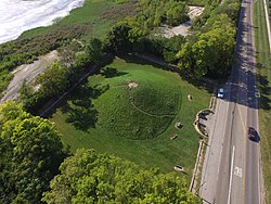
The Columbus Country Club Mound is a Native American burial mound at the Columbus Country Club in Columbus, Ohio. The mound was created around 2,000 years ago by the Pre-Columbian Native American Adena culture. The site was added to the National Register of Historic Places in 1974.

Broad Street is a major thoroughfare in Central Ohio, predominantly in Franklin County and Columbus. It stretches east from West Jefferson at Little Darby Creek to Pataskala. The street is considered one of Columbus's two main roads, along with High Street.

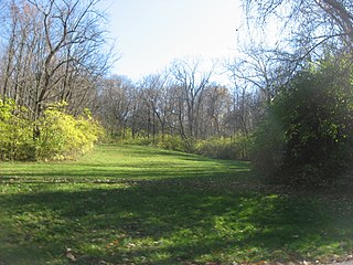
The Hartley Mound is a Native American burial mound in Columbus, Ohio. The mound was created around 2,000 years ago by the Pre-Columbian Native American Adena culture. The site was added to the National Register of Historic Places in 1974. The mound measures 2 ft. high and 43 ft. in diameter. The site's location near a tributary to a major waterway, artifacts found nearby, and the small subconical form of the mound, suggests that it was built by the Adena culture. It is one of few mounds not seriously disturbed by agriculture, industry, or illegal excavation. Upon archaeological excavation, the site should provide information on Adena burial customs and domestic or mortuary structures.