Briggsdale (Columbus, Ohio)

Last updated
Typical homes in Briggsdale BriggsdaleHomes.JPG
Typical homes in Briggsdale
Briggsdale (Columbus, Ohio)
Interactive map of the neighborhood

Briggsdale is a neighborhood of Franklin County in the city of Columbus, Ohio. The neighborhood is on the west/southwest side of the city within the Hilltop area. The area was first settled and founded by the family of Joseph M. Briggs, after whom the neighborhood was named. Joseph Briggs was an active figure in the early years of the township and county operations. The Briggsdale Methodist church was founded with his help, and it now exists as the New Horizons Methodist Church. The present-day Briggsdale neighborhood is located near the historical Green Lawn Cemetery to the north as well as Briggs High School to the west.

Contents

History

Family history

Joseph M. Briggs JosephMBriggs.jpg
Joseph M. Briggs

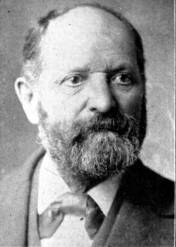
Joseph M. Briggs was born on November 25, 1833 [1] to Nicholas Joseph Briggs and Martha J. Chambers in Columbus, Franklin County, Ohio. Joseph M. Briggs was raised on the family's home farm and attended Ohio Wesleyan University, where he met his wife Louisiana Ransburgh, who was 17 years old at the time, 16 years younger. They married October 16, 1867. [2] Briggs died August 31, 1913, of a fractured rib. He and his wife, who died from choking on brandy in 1950 while hospitalized at Mount Carmel for bronchial pneumonia, are buried alongside each other at Green Lawn Cemetery on Sullivant Avenue just north of the present-day Briggsdale neighborhood. [3]

Joseph M. Briggs was a prominent and influential citizen of Franklin Township. He served as the township accessor prior to serving as treasurer for six years. In 1880, he was elected as county commissioner then reelected in 1883 for a total of six years. While county commissioner, Briggs activated several substantial county improvements including the construction of the Broad Street and State Street bridges. Beginning in 1887, he served as the postmaster of Briggsdale. Briggs was also a member and trustee of the Briggsdale Methodist church to which he contributed funding for the new building. In addition to his service for the county, Joseph Briggs possessed a lot of high-value property in the city of Columbus including 27 residences from which he accumulated great wealth from renting. [4]

Louisiana Ransburgh, wife of Joseph M. Briggs, became a historic cultural figure of the area known as the ″Veiled Lady of Champ Chase.″ Each year, in the cover of the night, Louisiana slipped out of the house donning dark clothing and a veil and placed flowers on the graves of confederate soldiers buried at the Camp Chase Confederate Cemetery (also known as the Green Lawn Cemetery). Louisiana's efforts helped clean up the forgotten and overgrown cemetery grounds. [5]

Geography

The present-day neighborhood is bounded by Briggs Road, Eakin Road, and Hopkins Avenue on the north, Brown Road on the east, Demorest Road on the west, and Clime Road on the South. [6] The current neighborhood covers about 0.04 square miles. Briggsdale is approximately five miles outside of downtown Columbus. The neighborhood is located nearby Harrisburg Pike (Route 62) and the passenger railroad tracks operated by the Columbus and Xenia Railroad.

Transportation

The Briggsdale neighborhood is serviced by the COTA bus Grove City Local Lines #3 and #9 . This line runs along Harrisburg Pike. [7]

Structures and landmarks

New Horizons Methodist Church

New Horizons Methodist Church NewHorizonsMethodistChurch.jpg
New Horizons Methodist Church

Originally a pioneer class of Methodism meeting in a community member's home, the Briggsdale Methodist Church began in 1822. The meetings moved to a log house on land donated by the family of Samuel White. The log house was replaced by a brick building in 1844 and later another building in 1902 to accommodate the growing congregation. The church was forced to close in 1917 but reopened in 1924. Then in 1928, the original structure burned down. The main sanctuary was rebuilt in 1929 by W.S. Brown. In 2001, the Briggsdale Church merged with the Salem Heights Methodist Church of Grove City, Ohio, to form the current New Horizons United Methodist Church. [8]

New Horizons Methodist Church is a red brick building located on Harrisburg Pike near the southern edge of Briggsdale. The Briggsdale Apartments complex is across the street from the church. New Horizons continues traditions from the historical Briggsdale Church congregation such as the Chicken and Noodle Dinner originating over 50 years ago. [9]

Briggs Mart

Briggs Mart is a small convenience store located on Briggs Road down the street from the High School.

Residential

Briggsdale Apartments

Briggsdale Apartments Community Housing Network BriggsdaleApartments.jpg
Briggsdale Apartments Community Housing Network

The Briggsdale Apartments are a built aspect of the Rebuilding Lives Program, a community effort to end chronic homelessness in Franklin County. Opening in March 2006 for occupancy, the apartment complex was developed and is owned and operated by the Community Housing Network. The construction cost under $4 million and took place from July 2005 to February 2006. [10] The project received large community support through funding from the Ohio Housing Finance Agency, HOME funds from the city of Columbus, Franklin County, and HUD. The apartments are supportive single room occupancy (SRO) units for individuals disabled by mental illness, afflicted by substance addiction, or have experienced a history of chronic homelessness. The complex consists of two buildings designed to look like farm residences in the spirit of the original Briggs farm. [11] The apartment complex is located at 1670 Harrisburg Pike, Columbus, Ohio. The location was selected because of its proximity to public transportation, convenience shopping and employment opportunities for the residents. The apartments include 35 SRO units, a community space, computer lab for resident use and offices for 24-hour staffing. The Community Housing Network works in conjunction with the Southeast, Inc. to provide the apartment residents with supportive services such as mental health and chemical dependency counseling and budgeting education. [12]

Education

Briggsdale School

The school building, located on Harrisburg Road, was built in 1909 but since then has been demolished. [13]

Briggs High School

Briggs High School BriggsHighSchool.jpg
Briggs High School

Briggs High School, located northwest of the neighborhood on Briggs Road, is part of the Columbus City Schools network. The public school accommodates grades 9-12. The school colors are purple and gold, and the sports mascot is the Bruin. [14] Briggs High School offers traditional CCS college preparatory curriculum as well as Advanced Placement courses and special elective courses. [15]

See also

Related Research Articles

<span class="mw-page-title-main">Lincoln Village, Ohio</span> Census-designated place in Ohio, United States

Lincoln Village is a census-designated place (CDP) in Prairie Township, Franklin County, Ohio, United States. It is centered near the intersection of US 40 and I-270 on the west side of Columbus. As of the 2020 census, the population was 9,702.

<span class="mw-page-title-main">Victorian Village</span> Neighborhood of Columbus in Franklin, Ohio, United States

Victorian Village is a neighborhood in Columbus, Ohio, United States, north and near west of downtown. It is an established neighborhood built when a streetcar line first ran along Neil Avenue around 1900 with a fair number of established trees for an urban setting. To preserve, protect and enhance the unique architectural and historical features, the Victorian Village Historic District was established in 1973. Columbus Monthly named this neighborhood the top place to live for Arts and Entertainment, with fun right around the corner in the Short North as its neighborhood hangout.

<span class="mw-page-title-main">Bridesburg, Philadelphia</span> Former Borough in Pennsylvania, United States

Bridesburg is the northernmost neighborhood in the River Wards section of Philadelphia, Pennsylvania, United States. Bridesburg is an historically German and Irish community, with a significant community of Polish immigrants who arrived mostly in the early- to mid-twentieth century. The community is home to two Catholic churches: All Saints Church, designed by Edwin Forrest Durang, built in 1889; and Saint John Cantius Church, built in 1898 in Polish Cathedral style.

<span class="mw-page-title-main">Westgate (Columbus, Ohio)</span> Neighborhood of Columbus in Franklin, Ohio, United States

Westgate is a community within the Hilltop area of Columbus, Ohio. It was partially constructed on land that formerly housed the American Civil War Camp Chase and a Confederate prison. After the Civil War, the land was purchased by Joseph Binns and his associates with the intent to start a Quaker community. These plans failed to materialize and the land was developed as a "streetcar suburb" in the 1920s. Located 4 miles (6.4 km) west of downtown, the neighborhood is home to Westgate Park and Recreation Center, Westgate Alternative Elementary School, St. Mary Magdalene Church and school, and Parkview United Methodist Church. 4,500 residents live within the Westgate boundaries, most in single family houses.

<span class="mw-page-title-main">Franklinton (Columbus, Ohio)</span> Neighborhood in Columbus, Ohio

Franklinton is a neighborhood in Columbus, Ohio, just west of its downtown. Settled in 1797, Franklinton is the first American settlement in Franklin County, and was the county seat until 1824. As the city of Columbus grew, the city annexed and incorporated the existing settlement in 1859. Franklinton is bordered by the Scioto River on the north and east, Harmon Avenue on the east, Stimmel Road and Greenlawn Avenue on the south, and Interstate 70 on the west. Its main thoroughfare is West Broad Street, one of the city's two main roads.

<span class="mw-page-title-main">Olentangy West (Columbus, Ohio)</span> Neighborhood in Columbus in Franklin, Ohio, United States

Olentangy West is a neighborhood approximately 5 miles (8 km) northwest of downtown Columbus, Ohio, United States. Also called West Olentangy, it is generally bordered by West Henderson Road on the north, the Olentangy River and Clintonville on the east, Kinnear Road on the south, and Upper Arlington on the west. The area is primarily residential, although the large Riverside Methodist Hospital and the headquarters for Chemical Abstracts Service are located within its boundaries. Additionally, the west campus of Ohio State University is located within the southern boundary of the area.

West Columbus, sometimes referred to as westside or the West Side, is a neighborhood in Columbus, Ohio, United States. Unlike other Columbus neighborhoods, it is a broad geographical term used by locals rather than a subdivision or suburb. West Columbus is defined as the entire southwest side of Columbus, bordered on the north by interstates 70 and 670, within Interstate 71 on the east, and on the south and west by the city limits that reach several miles to the outside of the I-270 outerbelt. It covers the ZIP Codes 43223, 43204, 43228, and 43222.

Columbus, the state capital and Ohio's largest city, has numerous neighborhoods within its city limits. Neighborhood names and boundaries are not officially defined. They may vary or change from time to time due to demographic and economic variables.

<span class="mw-page-title-main">Old Oaks Historic District</span> Neighborhood in Columbus in Franklin, Ohio, United States

Old Oaks Historic District, or Old Oaks, is a neighborhood just south and east of downtown Columbus, Ohio and is an example of a streetcar suburb in the city.

<span class="mw-page-title-main">Old North Columbus</span> Neighborhood in Columbus, Ohio

Old North Columbus is a neighborhood located just north of the Ohio State University in Columbus, Ohio. It was founded in 1847 where, at the time, it was a stand-alone city out of the confines of Columbus until it was incorporated into the City of Columbus in 1871. In its early years the city was a popular stagecoach stop with people traveling from Worthington to Columbus. Today Old North Columbus is popular for its local music and its unique "untouched architecture" which is reminiscent of its old roots.

<span class="mw-page-title-main">Woodland Park (Columbus, Ohio)</span> Neighborhood of Columbus in Franklin, Ohio, United States

Woodland Park is a residential neighborhood located in the Near East Side of Columbus, Ohio that houses approximately 1,500 residents. The neighborhood was previously home to such figures as artist Emerson Burkhart, cartoonist Billy Ireland, and judge William Brooks. Established in the early 20th century, Woodland Park has grown from its planned neighborhood roots into a modest neighborhood that contains various faith communities, schools, sources of entertainment and recreation, and borders an extension of the Ohio State University medical center.

<span class="mw-page-title-main">Franklin Park (Columbus, Ohio)</span> Place

Franklin Park is a neighborhood located on the Near East Side of Columbus, Ohio. Both the historic neighborhood and landmark, the Franklin Park Conservatory and Botanical Gardens, are named after the 88-acre park.

<span class="mw-page-title-main">Discovery District (Columbus, Ohio)</span> Neighborhood in Columbus, Ohio

The Discovery District is a special improvement district in downtown Columbus, Ohio, the home of Columbus State Community College, Columbus College of Art and Design, Columbus Museum of Art, and Columbus Metropolitan Library. It is considered a cultural district because of its close proximity to higher educational campuses and art destinations. It was named to imply that the area is full of possibility due to the number of learning and creative campuses in this small area. "Culture, art, and academia converge and present the Discovery District." While not typically viewed as the most prominent Columbus neighborhood, the density of academic and arts-based institutions in this area are what make this creative campus unique.

<span class="mw-page-title-main">Fifth by Northwest</span> Neighborhood in Columbus, Ohio

Fifth by Northwest is a neighborhood in Columbus, Ohio. Covering about 700 acres (280 ha), Fifth by Northwest is approximately bound by Glenn Avenue, Wyandotte Road, & Kinnear to the north, Third Avenue to the south, Kenny Road and Olentangy River Road to the east and Northstar Road to the west. Also sometimes referred to as 5XNW or the Tri-Village area, Fifth by Northwest is just north of Grandview Heights, northwest of the Harrison West neighborhood, and west of The Ohio State University.

Robtown is an unincorporated community in Pickaway County, in the U.S. state of Ohio. The area is located approximately five miles west of South Bloomfield, Ohio and three miles northeast of Darbyville, Ohio, on the banks of Grave Run, a tributary of the Scioto River, and at the crossroads of Ohio State Route 316 and Turney Caldwell Road.

<span class="mw-page-title-main">Public transit in Columbus, Ohio</span> Overview of public transportation in Columbus, Ohio

Public transit has taken numerous forms in Columbus, the largest city and capital of Ohio. Transit has variously used passenger trains, horsecars, streetcars, interurbans, trolley coaches, and buses. Current service is through the Central Ohio Transit Authority's bus system, numerous intercity bus companies, and through bikeshare, rideshare, and electric scooter services.

<span class="mw-page-title-main">10 E Broad / W Broad</span> Bus line in Columbus, Ohio

The 10 E Broad / W Broad is a Central Ohio Transit Authority (COTA) bus service in Columbus, Ohio. The line operates on Broad Street, the city's main east-west thoroughfare.

<span class="mw-page-title-main">Columbus Railway, Power & Light office</span> Former railway building in Columbus, Ohio

The former Columbus Railway, Power & Light office is a historic building in the Milo-Grogan neighborhood of Columbus, Ohio. The two-story brick structure was designed by Yost & Packard and built in the 1890s as a transportation company office. The property was part of a complex of buildings, including a power plant, streetcar barn, and inspection shop. The office building, the only remaining portion of the property, was utilized as a transit office into the 1980s, and has remained vacant since then. Amid deterioration and lack of redevelopment, the site has been on Columbus Landmarks' list of endangered sites since 2014.

<span class="mw-page-title-main">Northland (Columbus, Ohio)</span> Neighborhood in Columbus, Ohio

Northland is a residential and commercial area in northeast Columbus, Ohio. The area is served by the Northland Community Council, which oversees land east of Worthington, roughly north of Morse Road, south of I-270, and west of New Albany, including the neighborhood Forest Park and the independent village of Minerva Park.

References

  1. "Joseph M. Briggs portrait :: Columbus in Historic Photographs". digital-collections.columbuslibrary.org. Retrieved 2016-04-09.
  2. "Archived copy" (PDF). Archived from the original (PDF) on 2016-03-04. Retrieved 2014-11-12.{{cite web}}: CS1 maint: archived copy as title (link)
  3. Taylor, William Alexander (1909-01-01). Centennial History of Columbus and Franklin County, Ohio. S. J. Clarke Publishing Company.
  4. Taylor, William Alexander (1909-01-01). Centennial History of Columbus and Franklin County, Ohio. S. J. Clarke Publishing Company.
  5. "Joseph M. Briggs portrait :: Columbus in Historic Photographs". digital-collections.columbuslibrary.org. Retrieved 2016-04-09.
  6. "Neighborhoods". homes-columbus.com. Archived from the original on 2016-03-03. Retrieved 2016-04-09.
  7. http://www.cota.com/import/2014_COTA_SystemMap_08112014.pdf%5B%5D
  8. "History | New Horizons United Methodist Church". newhorizonsunitedmethodist.org. Archived from the original on 2016-04-01. Retrieved 2016-04-09.
  9. "History | New Horizons United Methodist Church". newhorizonsunitedmethodist.org. Archived from the original on 2016-04-01. Retrieved 2016-04-09.
  10. "Briggsdale - Community Housing Network". www.chninc.org. Archived from the original on 2016-03-04. Retrieved 2016-04-09.
  11. "A Grand Agrarian Design". Housing Finance. Retrieved 2016-04-09.
  12. "Briggsdale - Community Housing Network". www.chninc.org. Archived from the original on 2016-03-04. Retrieved 2016-04-09.
  13. "Old Ohio Schools - Franklin County". www.oldohioschools.com. Archived from the original on 2016-04-19. Retrieved 2016-04-09.
  14. Briggs High School (Columbus, Ohio)
  15. "Academics". briggshs.ccsoh.us. Retrieved 2016-04-09.

39°55′33″N83°03′30″W / 39.92583°N 83.05833°W / 39.92583; -83.05833