
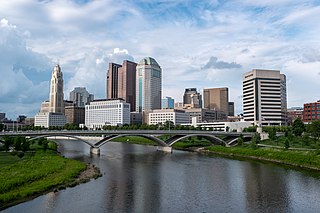
The city of Columbus is located in central Ohio at the confluence of the Scioto and Olentangy rivers. The region is dominated by a humid continental climate, characterized by hot, muggy summers and cold, dry winters.
The city of Columbus is located in central Ohio at the confluence of the Scioto and Olentangy rivers. The region is dominated by a humid continental climate, characterized by hot, muggy summers and cold, dry winters.

According to the United States Census Bureau, the city has a land area of 220.04 square miles (569.9 km2). [1] . Unlike many other major US cities in the Midwest, Columbus continues to expand its reach by way of extensions and annexations, making it one of the fastest growing large cities in the nation, in terms of both geography and population, and probably the fastest in the Midwest.[ citation needed ] While Columbus' suburban population is not as large as Ohio's other two large metro areas, (Cleveland and Cincinnati), due to its annexation policies, it is almost entirely ringed by suburbs, and it even has some land-locked suburbs which are completely surrounded by Columbus' city limits. Some of Columbus' largest suburbs are Westerville, Gahanna, Reynoldsburg, Grove City, Upper Arlington, Hilliard and Dublin. Since the 1950s the city has made annexation a condition for providing water and sewer service, to which it holds regional rights throughout a large portion of central Ohio. This policy is credited with preserving Columbus' tax base in the face of the U.S.'s suburbanization and has contributed to its continued economic expansion, much like other cities pursuing similar policies such as San Antonio, Texas.
The confluence of the Scioto and Olentangy rivers occurs just west of downtown Columbus. Several smaller tributaries course through the Columbus metro area, including Alum Creek, Big Walnut Creek, and Darby Creek. Columbus is considered to have relatively flat topography thanks to a large glacier that covered most of Ohio during the Wisconsin Ice Age. However, there are sizable differences in elevation through the area, with the high point of Franklin County being 1132 ft (345 m) above sea level near New Albany, and the low point being 670 ft (207 m) where the Scioto River leaves the county near Lockbourne. [2] Numerous ravine areas near the rivers and creeks also help give some variety to the landscape. Tributaries to Alum Creek and the Olentangy River cut through shale, while tributaries to the Scioto River cut through limestone. Deciduous trees are common, including maple, oak, hickory, walnut, poplar, cottonwood, and of course, buckeye.
Columbus is geographically very close to many major cities. It has a driving distance of less than four hours from Cincinnati, Cleveland, Detroit, Fort Wayne, Indianapolis, Lexington, Louisville, Pittsburgh, and Toledo. Likewise, Chicago, Milwaukee, Nashville, New York City, Washington, DC, St Louis, Atlanta, Charlotte, and Philadelphia are all within a day's drive of the city.
| Columbus | ||||||||||||||||||||||||||||||||||||||||||||||||||||||||||||
|---|---|---|---|---|---|---|---|---|---|---|---|---|---|---|---|---|---|---|---|---|---|---|---|---|---|---|---|---|---|---|---|---|---|---|---|---|---|---|---|---|---|---|---|---|---|---|---|---|---|---|---|---|---|---|---|---|---|---|---|---|
| Climate chart (explanation) | ||||||||||||||||||||||||||||||||||||||||||||||||||||||||||||
| ||||||||||||||||||||||||||||||||||||||||||||||||||||||||||||
| ||||||||||||||||||||||||||||||||||||||||||||||||||||||||||||
The city has, depending on definition, a humid continental or humid subtropical climate (Köppen climate classification Dfa or Cfa) characterized by hot, muggy summers and cold, comparatively dry winters, and lies in USDA Plant Hardiness Zone 6. [3] January averages 29.6 °F (−1.3 °C), while July averages 75.2 °F (24.0 °C). Spring and autumn are mild and wet, but the latter is usually drier. The annual mean is 53.4 °F (11.9 °C). On average, temperatures reach 90 °F (32 °C) on 18 days of the year and 0 °F (−18 °C) on 2.9 nights, while the first freeze occurs on October 23 and the last on April 19.
The annual precipitation of 39.3 inches (998 mm) peaks, but not strongly so, in the latter half of spring and then summer; July is the wettest month while February is the driest. Passing cold fronts in winter frequently produce snow that is occasionally heavy, with a seasonal average of 28.1 inches (71.4 cm). On average, the first date of measurable, i.e. totalling 0.1 inches (0.25 cm) or more, snowfall is November 21 and the last March 31, with falls in October quite rare.
The hottest temperature ever recorded in Columbus was 106 °F (41 °C), which occurred twice during the Dust Bowl drought of the 1930s — once on July 21, 1934, and again two years later, on July 14, 1936. [4] The coldest temperature ever recorded was −22 °F (−30 °C), occurring on January 19, 1994. [4] The highest daily minimum temperature was 82 °F (28 °C) on January 10, 1881, and conversely, the lowest daily maximum was −7 °F (−22 °C) on February 9, 1899.
Columbus is subject to severe weather typical to the Midwestern United States. Severe thunderstorms producing tornadoes are possible from the spring to the fall, the most recent of which occurred on October 11, 2006 and caused F2 damage. [5] Floods and blizzards can also occur from time to time.
| Climate data for Columbus, Ohio (John Glenn Int'l), 1991–2020 normals, [lower-alpha 1] extremes 1878–present [lower-alpha 2] | |||||||||||||
|---|---|---|---|---|---|---|---|---|---|---|---|---|---|
| Month | Jan | Feb | Mar | Apr | May | Jun | Jul | Aug | Sep | Oct | Nov | Dec | Year |
| Record high °F (°C) | 74 (23) | 78 (26) | 85 (29) | 90 (32) | 96 (36) | 102 (39) | 106 (41) | 103 (39) | 100 (38) | 94 (34) | 80 (27) | 76 (24) | 106 (41) |
| Mean maximum °F (°C) | 60.7 (15.9) | 64.1 (17.8) | 73.6 (23.1) | 81.6 (27.6) | 88.3 (31.3) | 93.1 (33.9) | 93.7 (34.3) | 92.8 (33.8) | 90.2 (32.3) | 83.2 (28.4) | 70.5 (21.4) | 62.5 (16.9) | 95.0 (35.0) |
| Mean daily maximum °F (°C) | 37.1 (2.8) | 40.8 (4.9) | 51.1 (10.6) | 64.1 (17.8) | 74.1 (23.4) | 82.2 (27.9) | 85.4 (29.7) | 84.1 (28.9) | 77.8 (25.4) | 65.5 (18.6) | 52.3 (11.3) | 41.5 (5.3) | 63.0 (17.2) |
| Daily mean °F (°C) | 29.6 (−1.3) | 32.5 (0.3) | 41.6 (5.3) | 53.2 (11.8) | 63.3 (17.4) | 71.9 (22.2) | 75.4 (24.1) | 74.0 (23.3) | 67.2 (19.6) | 55.2 (12.9) | 43.6 (6.4) | 34.5 (1.4) | 53.5 (11.9) |
| Mean daily minimum °F (°C) | 22.0 (−5.6) | 24.2 (−4.3) | 32.0 (0.0) | 42.2 (5.7) | 52.4 (11.3) | 61.6 (16.4) | 65.4 (18.6) | 63.9 (17.7) | 56.5 (13.6) | 44.8 (7.1) | 35.0 (1.7) | 27.4 (−2.6) | 43.9 (6.6) |
| Mean minimum °F (°C) | 1.7 (−16.8) | 6.3 (−14.3) | 14.5 (−9.7) | 27.1 (−2.7) | 37.8 (3.2) | 48.6 (9.2) | 55.7 (13.2) | 54.3 (12.4) | 43.2 (6.2) | 31.1 (−0.5) | 20.6 (−6.3) | 11.0 (−11.7) | −0.9 (−18.3) |
| Record low °F (°C) | −22 (−30) | −20 (−29) | −6 (−21) | 14 (−10) | 25 (−4) | 35 (2) | 43 (6) | 39 (4) | 31 (−1) | 17 (−8) | −5 (−21) | −17 (−27) | −22 (−30) |
| Average precipitation inches (mm) | 3.00 (76) | 2.41 (61) | 3.62 (92) | 3.85 (98) | 3.99 (101) | 4.33 (110) | 4.67 (119) | 3.74 (95) | 3.14 (80) | 2.90 (74) | 2.79 (71) | 3.13 (80) | 41.57 (1,056) |
| Average snowfall inches (cm) | 9.5 (24) | 7.6 (19) | 4.1 (10) | 0.5 (1.3) | 0.0 (0.0) | 0.0 (0.0) | 0.0 (0.0) | 0.0 (0.0) | 0.0 (0.0) | 0.2 (0.51) | 1.2 (3.0) | 5.1 (13) | 28.2 (72) |
| Average precipitation days (≥ 0.01 in) | 14.7 | 11.8 | 12.5 | 13.7 | 14.0 | 11.7 | 10.9 | 9.5 | 8.7 | 10.0 | 10.5 | 12.7 | 140.7 |
| Average snowy days (≥ 0.1 in) | 9.0 | 6.7 | 4.0 | 1.0 | 0.0 | 0.0 | 0.0 | 0.0 | 0.0 | 0.1 | 1.9 | 5.6 | 28.3 |
| Average relative humidity (%) | 71.4 | 69.5 | 64.5 | 62.5 | 66.5 | 68.5 | 70.6 | 72.8 | 72.8 | 69.3 | 71.8 | 74.1 | 69.5 |
| Average dew point °F (°C) | 18.1 (−7.7) | 20.5 (−6.4) | 28.6 (−1.9) | 37.4 (3.0) | 48.9 (9.4) | 58.3 (14.6) | 62.8 (17.1) | 61.7 (16.5) | 55.2 (12.9) | 42.6 (5.9) | 33.6 (0.9) | 24.3 (−4.3) | 41.0 (5.0) |
| Mean monthly sunshine hours | 110.6 | 126.3 | 162.0 | 201.8 | 243.4 | 258.1 | 260.9 | 235.9 | 212.0 | 183.1 | 104.2 | 84.3 | 2,182.6 |
| Percent possible sunshine | 37 | 42 | 44 | 51 | 55 | 57 | 57 | 56 | 57 | 53 | 35 | 29 | 49 |
| Average ultraviolet index | 2 | 3 | 4 | 6 | 8 | 9 | 9 | 8 | 6 | 4 | 2 | 1 | 5 |
| Source: NOAA (sun, relative humidity, and dew point 1961–1990) [6] [7] [8] [9] and Weather Atlas [10] | |||||||||||||

Columbus also has a number of distinctive neighborhoods within the metro area. The Short North, situated just north of downtown, is rich with art galleries, dining, pubs, and specialty shops. A number of large, ornate Victorian homes are located nearby, and together they comprise Victorian Village. Just to the west is Harrison West and across the Olentangy River is Grandview Heights. To the south, German Village is known for its quaint 19th-century brick cottages, and it holds the distinction as the largest privately funded historic district on the National Register of Historic Places. Immediately west is the Brewery District, formerly an entertainment district which has seen a decrease in bars and an increase in residential and office development. To the east of Downtown north of Broad St. is King-Lincoln Bronzeville, or just "King-Lincoln", which was the cultural and commercial hub of the African-American community. South of Broad and also east of King Lincoln is Olde Towne East, which was a well-to-do streetcar neighborhood consisting of grand homes in a wide variety of architectural styles. Most of these neighborhoods have all undergone gentrification on a large scale. Franklinton, sometimes known as "the Bottoms", is the neighborhood immediately west of downtown. Just to the west of Franklinton is a group of smaller neighborhoods collectively known as The Hilltop.
At the north end of downtown is a new development/neighborhood, the Arena District. Centered around the Nationwide Arena, the district has many pubs, restaurants, and residential projects, most notably the new 20-story Condominiums at North Bank Park tower. The Lifestyle Communities Pavilion is also an anchor for the district and the recently completed Huntington Ballpark has become the new home of the Columbus Clippers minor league baseball team.
There are also the Heritage Districts, which include the Driving Park, Livingston Park and Old Oaks areas on the near east side of the city, home to a part of the city's large black population.
The University area is populated by a high concentration of students during the school year (approximately 60,000) and features many old homes which have been converted to apartments for student use. The stretch of High Street that runs through the campus area caters to the student body with its abundance of bars, sandwich shops, music stores, and bookstores. Located between OSU and Worthington is Clintonville, where a mix of middle class homes can be found alongside beautiful old stone and brick-faced houses nestled among rolling hills. Further west of downtown, San Margherita is a community formed by Italian immigrants who arrived at the turn of the 20th century.

The city's street plan originates downtown and extends into the old-growth neighborhoods, following a grid pattern with the intersection of High Street (running north–south) and Broad Street (running east–west) at its center. North–south streets run twelve degrees west of due North, parallel to High Street; the Avenues (vis. Fifth Avenue, Sixth Avenue, Seventh Avenue, etc.) run east–west. [11] The address system begins its numbering at the intersection of Broad and High, with numbers increasing in magnitude with distance from Broad or High. Numbered Avenues begin with First Avenue, about 1¼ mile north of Broad Street, and increase in number as one progresses northward. Numbered Streets begin with Second Street, which is two blocks west of High Street, and Third Street, which is a block east of High Street, then progress eastward from there. Even-numbered addresses are on the north and east sides of streets, putting odd addresses on the south and west sides of streets. A difference of 700 house numbers means a distance of about one mile (along the same street). [2] For example, 351 W 5th Avenue is approximately one-half mile west of High Street on the south side of Fifth Avenue. Buildings along north–south streets are numbered in a similar manner: the building number indicates the approximate distance from Broad Street, the prefixes ‘N’ and ‘S’ indicate whether that distance is to measured to the north or south of Broad Street and the street number itself indicates how far the street is from the center of the city at the intersection of Broad and High.

This street numbering system does not hold true over a large area. The area served by numbered Avenues runs from about Marble Cliff to South Linden to the Airport, and the area served by numbered Streets covers Downtown and nearby neighborhoods to the east and south, with only a few exceptions. There are quite few intersections between numbered Streets and Avenues. Furthermore, named Streets and Avenues can have any orientation. For example, while all of the numbered avenues run east–west, perpendicular to High Street, many named, non-numbered avenues run north–south, parallel to High. The same is true of many named streets: while the numbered streets in the city run north–south, perpendicular to Broad Street, many named, non-numbered streets run east–west, perpendicular to High Street.
The addressing system, however, covers nearly all of Franklin County, with only a few older suburbs retaining self-centered address systems. The address scale of 700 per mile results in addresses approaching, but not usually reaching, 10,000 at the county's borders.
Other major, local roads in Columbus include Main Street, Morse Road, Dublin-Granville Road (SR-161), Cleveland Avenue/Westerville Road (SR-3), Olentangy River Road, Riverside Drive, Sunbury Road, Fifth Avenue and Livingston Avenue.
Columbus is bisected by two major Interstate Highways, Interstate 70 running east–west, and Interstate 71 running north to roughly southwest. The two Interstates combine downtown for about 1.5 miles (2.4 km) in an area locally known as "The Split", which is a major traffic congestion point within Columbus, especially during rush hour. U.S. Route 40, aka National Road, runs east–west through Columbus, comprising Main Street to the east of downtown and Broad Street to the west. U.S. Route 23 runs roughly north–south, while U.S. Route 33 runs northwest-to-southeast. The Interstate 270 Outerbelt encircles the vast majority of the city, while the newly redesigned Innerbelt consists of the Interstate 670 spur on the north side (which continues to the east past the Airport and to the west where it merges with I-70), State Route 315 on the west side, the I-70/71 split on the south side, and I-71 on the east. Due to its central location within Ohio and abundance of outbound roadways, nearly all of the state's destinations are within a 2-hour drive of Columbus.
The area has several airports, most notably John Glenn International Airport on the east side of the city. John Glenn International provides service to a few foreign and dozens of domestic destinations, including all the major hubs except Los Angeles, San Francisco, and Seattle. Port Columbus was a hub for discount carrier Skybus Airlines and is for NetJets, the world's largest fractional ownership air carrier. Rickenbacker International Airport, in southern Franklin County, is a major cargo facility and is important to the Ohio Air National Guard. OSU Don Scott Airport and Bolton Field are significant general-aviation facilities in the Columbus area.
Columbus used to have a major train station downtown called Union Station, most notably as a stop along Amtrak's National Limited train service until 1977. The station itself was razed in 1979, [12] and the Greater Columbus Convention Center now stands in its place. The station was also a stop along the Cleveland, Columbus and Cincinnati Railroad and the Pittsburgh, Cincinnati, Chicago and St. Louis Railroad. Columbus is now the largest metropolitan area in the U.S. without passenger rail service, after Phoenix introduced a light-rail system in December 2008; [13] [14] however studies are underway towards reintroducing passenger rail service to Columbus via the Ohio Hub project. A streetcar was planned in Downtown Columbus, and there was a plan for light rail service between downtown and the Polaris area. Plans to open a high-speed rail service connecting Columbus with Cincinnati and Cleveland were eliminated after Governor John Kasich was elected into office. [15]
Columbus maintains a widespread municipal bus service called the Central Ohio Transit Authority (COTA).
Bicycling as transportation is steadily increasing in Columbus with its relatively flat terrain, intact urban neighborhoods, large student population, and off-road bike paths. The city has recently put forth the 2012 Bicentennial Bikeways Plan as well as a move toward a Complete Streets policy. [16] Grassroots efforts such as Bike To Work Week, Consider Biking, Yay Bikes, [17] Third Hand Bicycle Co-op, Franklinton Cycleworks, and Cranksters, a local radio program focused on urban cycling, [18] have contributed to cycling as transportation.
Columbus also hosts urban cycling "off-shots" with messenger-style "alleycat" races as well as unorganized group rides, a monthly Critical Mass ride, [19] bicycle polo, art showings, movie nights, and a variety of bicycle-friendly businesses and events throughout the year. All this activity occurs despite Columbus's lack of on-road cycling lanes and frequently inclement weather.

Columbus is the capital and most populous city of the U.S. state of Ohio. With a 2020 census population of 905,748, it is the 14th-most populous city in the U.S., the second-most populous city in the Midwest after Chicago, and the third-most populous U.S. state capital after Phoenix, Arizona and Austin, Texas. Columbus is the county seat of Franklin County; it also extends into Delaware and Fairfield counties. It is the core city of the Columbus metropolitan area, which encompasses ten counties in central Ohio. It had a population of 2,138,926 in 2020, making it the largest metropolitan area entirely in Ohio and 32nd-largest metro area in the U.S.

Victorian Village is a neighborhood in Columbus, Ohio, United States, north and near west of downtown. It is an established neighborhood built when a streetcar line first ran along Neil Avenue around 1900 with a fair number of established trees for an urban setting. To preserve, protect and enhance the unique architectural and historical features, the Victorian Village Historic District was established in 1973. Columbus Monthly named this neighborhood the top place to live for Arts and Entertainment, with fun right around the corner in the Short North as its neighborhood hangout.

Hilltop is one of the largest neighborhoods in Columbus, Ohio, located west of Franklinton and Downtown. The Greater Hilltop area contains newer and historic neighborhoods, schools, various stores, industrial areas, and recreational facilities. The development pattern is considered a distinct suburb. The majority of the area is predominantly single family residential.

Franklinton is a neighborhood in Columbus, Ohio, just west of its downtown. Settled in 1797, Franklinton is the first American settlement in Franklin County, and was the county seat until 1824. As the city of Columbus grew, the city annexed and incorporated the existing settlement in 1859. Franklinton is bordered by the Scioto River on the north and east, Harmon Avenue on the east, Stimmel Road and Greenlawn Avenue on the south, and Interstate 70 on the west. Its main thoroughfare is West Broad Street, one of the city's two main roads.
The University District, is a 2.8-square-mile (7.3 km2) area located 2 miles (3.2 km) north of Downtown Columbus, Ohio that is home to the main campus of Ohio State University, the Battelle Institute, and Wexner Medical Center. It is generally accepted as the area bounded to the north by Clintonville at Glen Echo Ravine; to the south by the Short North at 5th Avenue; to the west by the Olentangy River and to east by the Conrail railroad tracks. Points of interest include, but are not limited to, the Ohio Stadium and Old North Columbus. The district is Columbus' most densely populated area and contains more than 650 businesses, human service agencies, churches, and schools. University District businesses include boutiques, mixed retail, several tattoo studios, the Gateway Film Center, and a diverse range of restaurants and bars.

Italian Village is a neighborhood in Columbus, Ohio, that contains an array of residential, commercial, and industrial buildings. It is a designated historic district, known for its historical and cultural preservation. The building types and architecture reflect Italian influence. With its parks and preserved historic homes, Italian Village has the highest home value appreciation in Columbus.

Olentangy West is a neighborhood approximately 5 miles (8 km) northwest of downtown Columbus, Ohio, United States. Also called West Olentangy, it is generally bordered by West Henderson Road on the north, the Olentangy River and Clintonville on the east, Kinnear Road on the south, and Upper Arlington on the west. The area is primarily residential, although the large Riverside Methodist Hospital and the headquarters for Chemical Abstracts Service are located within its boundaries. Additionally, the west campus of Ohio State University is located within the southern boundary of the area.
The Columbus, Ohio metropolitan area is a metropolitan area in Central Ohio surrounding the state capital of Columbus. As defined by the U.S. Census Bureau, it includes the counties of Delaware, Fairfield, Franklin, Hocking, Licking, Madison, Morrow, Perry, Pickaway, and Union. At the 2020 census, the MSA had a population of 2,138,926, making it 32nd-most populous in the United States and the second largest in Ohio, behind the Cincinnati metropolitan area. The metro area, also known as Central Ohio or Greater Columbus, is one of the largest and fastest-growing metropolitan areas in the Midwestern United States.
The Near East Side is a neighborhood located near downtown Columbus, Ohio, made up of several neighborhoods: Mount Vernon, King-Lincoln Bronzeville, Eastgate, Franklin Park, Nelson Park, Olde Towne East, and Woodland Park.
West Columbus, sometimes referred to as westside or the West Side, is a neighborhood in Columbus, Ohio, United States. Unlike other Columbus neighborhoods, it is a broad geographical term used by locals rather than a subdivision or suburb. West Columbus is defined as the entire southwest side of Columbus, bordered on the north by interstates 70 and 670, within Interstate 71 on the east, and on the south and west by the city limits that reach several miles to the outside of the I-270 outerbelt. It covers the ZIP Codes 43223, 43204, 43228, and 43222.

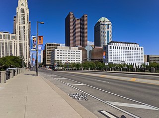
Downtown Columbus is the central business district of Columbus, Ohio. Downtown is centered on the intersection of Broad and High Streets, and encompasses all of the area inside the Inner Belt. Downtown is home to most of the tallest buildings in Columbus.

Olde Towne East is a neighborhood located in the historical Near East Side of Columbus, Ohio and is one of Columbus' oldest neighborhoods. The area has over 1,000 homes, some as old as the 1830s, and more than 50 architectural styles as a result of its history. These homes were built by many of the famous individuals of Columbus including industrialists, lawyers, judges, teachers, architects, mayors, governors, and legislators, many of whom shaped the city.
Columbus, the state capital and Ohio's largest city, has numerous neighborhoods within its city limits. Neighborhood names and boundaries are not officially defined. They may vary or change from time to time due to demographic and economic variables.

Harrison West is a historic urban neighborhood located northwest of downtown Columbus, Ohio. It sits on several blocks along the Olentangy River and includes the western part of the Near Northside Historic District, which was placed on the National Register of Historic Places in 1975. The character of the neighborhood is similar to Victorian Village, which sits just to the east and is more well-known.
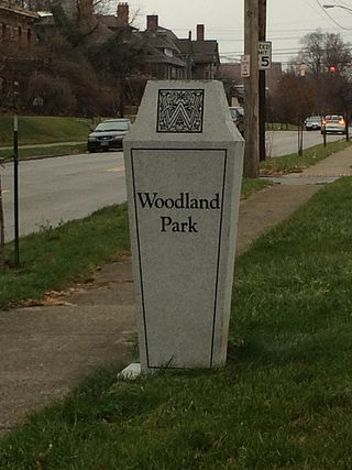
Woodland Park is a residential neighborhood located in the Near East Side of Columbus, Ohio that houses approximately 1,500 residents. The neighborhood was previously home to such figures as artist Emerson Burkhart, cartoonist Billy Ireland, and judge William Brooks. Established in the early 20th century, Woodland Park has grown from its planned neighborhood roots into a neighborhood that contains various faith communities, schools, sources of entertainment and recreation, and borders an extension of the Ohio State University medical center.
Northwest Columbus is a region in Franklin County, Ohio. It has about 45,000 residents, according to the 2010 U.S. census.
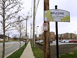
Fifth by Northwest is a neighborhood in Columbus, Ohio. Covering about 700 acres (280 ha), Fifth by Northwest is approximately bound by Glenn Avenue, Wyandotte Road, & Kinnear to the north, Third Avenue to the south, Kenny Road and Olentangy River Road to the east and Northstar Road to the west. Also sometimes referred to as 5XNW or the Tri-Village area, Fifth by Northwest is just north of Grandview Heights, northwest of the Harrison West neighborhood, and west of The Ohio State University.
Columbus, the capital city of Ohio, was founded on the east bank of the Scioto River in 1812. The city was founded as its capitol, beside the town of Franklinton, since incorporated into Columbus. The city's early history was gradual, as residents dealt with flooding and cholera epidemics, and the city had few direct connections to other cities. This led creation of a feeder canal, and later, freight and passenger railroads. The city became known for its industry and commercial businesses into the 20th century, though it experienced a lull in development in the late 20th century. In the 21st century, Columbus has been increasingly revitalized, led by parks projects, new developments, and efforts to beautify individual neighborhoods.
Broad Street is a major thoroughfare in Central Ohio, predominantly in Franklin County and Columbus. It stretches east from West Jefferson at Little Darby Creek to Pataskala. The street is considered one of Columbus's two main roads, along with High Street.

The Great Flood of 1913 severely affected Columbus, Ohio. The area most affected was Franklinton, also known as the Bottoms, for its low elevation near the Scioto River. Among many infrastructure projects, a 7.2-mile floodwall was built from 1993 to 2004 to protect most of Franklinton from flooding.
| Topics |  | ||||||
|---|---|---|---|---|---|---|---|
| Neighborhoods | |||||||
| Enclaves | |||||||
| History |
| ||||||
| Attractions | |||||||
| Government |
| ||||||
| Education |
| ||||||
| Transportation |
| ||||||
| Sports |
| ||||||
| Museums |
| ||||||
| |||||||