
Pickaway County is a county in the U.S. state of Ohio. As of the 2020 census, the population was 58,539. Its county seat is Circleville. Its name derives from the Pekowi band of Shawnee Indians, who inhabited the area.

Franklin County is a county in the U.S. state of Ohio. As of the 2020 census, the population was 1,323,807, making it the most populous county in Ohio. Most of its land area is taken up by its county seat, Columbus, the state capital and most populous city in Ohio. The county was established on April 30, 1803, less than two months after Ohio became a state, and was named after Benjamin Franklin. Originally, Franklin County extended north to Lake Erie before it was subdivided into smaller counties. Franklin County is the central county of the Columbus, Ohio Metropolitan Statistical Area.

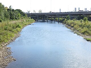
The Scioto River is a river in central and southern Ohio more than 231 miles (372 km) in length. It rises in Hardin County just north of Roundhead, Ohio, flows through Columbus, Ohio, where it collects its largest tributary, the Olentangy River, flows south into Appalachian Ohio, and meets the Ohio River at Portsmouth. Early settlers and Native Americans used the river for shipping, but it is too small for modern commercial craft. The primary economic importance for the river now is for recreation and drinking water. It is the longest river that is entirely within Ohio.

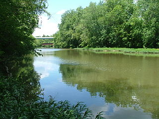
The Little Miami River is a Class I tributary of the Ohio River that flows 111 miles (179 km) through five counties in southwestern Ohio in the United States. The Little Miami joins the Ohio River east of Cincinnati. It forms parts of the borders between Hamilton and Clermont counties and between Hamilton and Warren counties. The Little Miami River is one of 156 American rivers designated by the U.S. Congress or the Secretary of the Interior as a National Wild and Scenic River and lends its name to the adjacent Little Miami Scenic Trail.
The Olentangy River is a 97-mile-long (156 km) tributary of the Scioto River in Ohio, United States.
Scioto is a word of Wyandot origin given to the Scioto River, which flows southwards from north central Ohio to the Ohio River.
Paint Creek is a tributary of the Scioto River, 94.7 miles (152.4 km) long, in south-central Ohio in the United States. Via the Scioto and Ohio Rivers, it is part of the watershed of the Mississippi River. It drains an area of 1,143 square miles (2,960 km2).

Alum Creek is a 58-mile (93 km) long creek that runs north to south in central Ohio. The creek originates in Morrow County and then flows through Delaware County and finally into Franklin County, where it ends at Big Walnut Creek, which drains into the Scioto River. Alum Creek is a source of drinking water for the city of Westerville, Ohio.

The Columbus and Franklin County Metro Parks are a group of 20 metropolitan parks in and around Columbus, Ohio. They are officially organized into the Columbus and Franklin County Metropolitan Park District. The Metro Parks system was organized in 1945 under Ohio Revised Code Section 1545 as a separate political division of the state of Ohio. The Metro Parks are overseen by a Board of Park Commissioners consisting of three citizens appointed to three-year terms without compensation by the Judge of the Probate Court of Franklin County, Ohio. The Board in turn appoints an Executive Director responsible for operations and management of the parks.
West Columbus, sometimes referred to as westside or the West Side, is a neighborhood in Columbus, Ohio, United States. Unlike other Columbus neighborhoods, it is a broad geographical term used by locals rather than a subdivision or suburb. West Columbus is defined as the entire southwest side of Columbus, bordered on the north by interstates 70 and 670, within Interstate 71 on the east, and on the south and west by the city limits that reach several miles to the outside of the I-270 outerbelt. It covers the ZIP Codes 43223, 43204, 43228, and 43222.

Big Walnut Creek starts near Mount Gilead, Ohio in Morrow County. It flows south to eastern Delaware County and parallels Alum Creek. It passes to the east of Sunbury and into Hoover Reservoir, which then crosses into Franklin County. From the dam outflow in Westerville the creek flows through Gahanna and Whitehall. Near Obetz it is joined by its principal tributaries Alum Creek and Blacklick Creek at the Three Creeks Columbus Metro Park. It flows through southern Franklin County and joins the Scioto River near the Franklin-Pickaway Counties line at 39°47′57″N83°00′34″W.

Pleasant Township is one of the seventeen townships of Franklin County, Ohio, United States. As of the 2020 census, the population was 6,757.

Scioto Township is one of the fifteen townships of Pickaway County, Ohio, United States. The 2020 United States Census found 11,712 people in the township.
The Scioto madtom was a species of fish in the family Ictaluridae. It is listed as extinct by the International Union for Conservation of Nature, which notes that it has likely been entirely or functionally extinct since 1957 given the lack of records since that year.

Darbydale is an unincorporated community and census-designated place (CDP) in central Pleasant Township, Franklin County, Ohio, United States. It was an incorporated village until its disincorporation on December 27, 1985. As of the 2020 census, the population was 768.

Georgesville is an unincorporated community in western Pleasant Township, Franklin County, Ohio, United States. It is located southwest of Columbus, the county seat of Franklin County and the capital and largest city of Ohio.
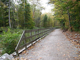
The Ohio to Erie Trail is a dedicated multi-use trail crossing Ohio from southwest to northeast, crossing 326 mi (525 km) of regional parks, nature preserves, and rural woodland.
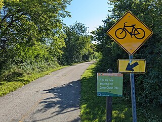
The Camp Chase Trail is a paved multi-use trail in Madison and Franklin counties in the U.S. state of Ohio. It serves as the Southwest Columbus segment of the 326-mile (525 km) Ohio to Erie Trail. The entire length of the Camp Chase Trail is part of the Great American Rail-Trail, U.S. Bicycle Route 21 and U.S. Bicycle Route 50.

The Little Darby Creek is a tributary to the Darby Creek System in central Ohio. The creeks are part of the Scioto River drainage basin. Little Darby Creek runs from an area near the Lafayette-Plain City Road Bridge downstream to the confluence with Big Darby Creek near the Darby Creek Metro Park. The village of Georgesville, Ohio, forms the western edge of the Confluence.

Battelle Darby Creek Metro Park is a metropolitan park in Central Ohio, owned and operated by Columbus and Franklin County Metro Parks. The park is within the Pleasant and Prairie townships, southwest of Columbus. It is the largest park in the Metro Parks system, with 7,103 acres (2,874 ha).


