Chagrin River

Last updated
Chagrin River
Chagrin river at south chagrin reservation.JPG
Chagrin River from South Chagrin Reservation
Location
Country United States
State Ohio
Physical characteristics
Source Bass Lake, Ohio
  location Munson Township, Northeast Ohio
Mouth Chagrin Harbor
  location
Eastlake, Lake County, OH
  coordinates
41°40′36″N81°26′13″W / 41.67667°N 81.43694°W / 41.67667; -81.43694 Coordinates: 41°40′36″N81°26′13″W / 41.67667°N 81.43694°W / 41.67667; -81.43694
Discharge 
  location Eastlake, OH

The Chagrin River is located in Northeast Ohio. [1] The river has two branches, the Aurora Branch and East Branch. Of three hypotheses as to the origin of the name, the most probable is that it is a corruption of the name of a Frenchman, Sieur de Seguin, who established a trading post on the river ca. 1742. [2] [3] [4] The Chagrin River runs through suburban areas of Greater Cleveland in Cuyahoga, Geauga, and Portage counties, transects two Cleveland Metroparks reservations, and then meanders into nearby Lake County before emptying into Lake Erie.

Contents

The East Branch [5] begins in Geauga County, flows north then west through Lake County, largely in Kirtland, and Kirtland Hills, In these communities the East Branch transects the Holden Arboretum, before intersecting the main in Willoughby.

The Aurora Branch [6] begins in northwest Portage County, flowing northwest through Aurora and portions of Geauga and Cuyahoga Counties, intersecting the main branch west of Chagrin Falls.

The Chagrin River was designated as a state scenic river in 1979.

Natural history

Along its banks and tributaries Berea sandstone, Bedford shale, Cleveland Shale, and Chagrin Shale bedrock, are exposed in layers. The river itself was cut through the Allegheny Plateau as glaciers receded in the area at the end of the Wisconsin glaciation.

The lowest visible bedrock is Chagrin shale. Named for the river and easily found in the river valley. Chagrin shale, is blue gray in color, an offshore alluvial, silt shale of the Devonian period. This layer is found below about 800 feet (240 m) msl.

The next layer is Cleveland shale. This is a black shale that is an important source of local fossils. Cleveland Shale is found in the Chagrin River valley between 800 and 900 feet (270 m) msl.

Bedford Shale is found above the Cleveland Shale layer. This material marks the uncertain transition between the Devonian and Pennsylvanian periods in the region and is also an important source of local fossils. This layer is found in the ravines that carry tributaries of the Chagrin River. Bedford shale is a sand shale and is characterized by its roughly 90° cleavage pattern. Pieces of Bedford shale can look as if they were cut by human hands and are found up to about 950 feet (290 m) msl.

Berea sandstone is found from around 950 feet (290 m) msl to roughly 1,070 feet (330 m) msl. Berea sandstone, is an important local building material. In the nineteenth century it was quarried from the base of Gildersleeve Mountain (in the East Branch watershed). This material was used to build Kirtland Temple and other local structures. Berea sandstone is still used as a local building material
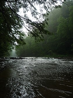
According to the Ohio Department of Natural Resources, more than 49 species of fish and 90 bird species live in the Chagrin River watershed, including the American brook lamprey, which is relatively rare in Ohio.

Sports and recreation

Hiking is popular along many areas along the Chagrin River. [7] Some area are also popular for fishing, and ESPN Outdoors recommends the Chagrin River for fishing, [8] especially for finding steelhead. The Daniels Park Dam, a small lowhead dam, was their favorite spot. On December 31, 2004, the Daniels Park Dam failed due to excess pressure from ice and water. [9]

The Aurora branch of the Chagrin River is a class III-IV of whitewater, according to the American Whitewater Association. [10] On the other hand, the Daniels Park section is rated a class I.

Channelization

In 2007, in violation of both state law and Federal Regulations, the 8,700 feet (2,700 m) of the East Branch of the river was channelized and diked to prevent flooding on agricultural land owned by the Village of Kirtland Hills. This activity was conducted by local developer Jerome Osborne who leases the land from the village. Both the village and Osborne have been cited for this illegal activity. [11] This activity both threatened the riparian floodplain in the area of disruption, and increases the likelihood and severity of flooding in downstream the communities of Willoughby and Eastlake. As of September 2007, a plan was being developed to restore the East Branch to its original condition, and further action against the cited parties is being considered. [11]

See also

Related Research Articles

<span class="mw-page-title-main">Lake County, Ohio</span> County in Ohio, United States

Lake County is a county in the U.S. state of Ohio. As of the 2020 census, the population was 232,603. The county seat is Painesville. The county was established on March 6, 1840, from land given by Cuyahoga and Geauga Counties. Its name is derived from its location on the southern shore of Lake Erie. Lake County is part of the Cleveland-Elyria, OH Metropolitan Statistical Area.

<span class="mw-page-title-main">Geauga County, Ohio</span> County in Ohio, United States

Geauga County is a county in the U.S. state of Ohio. As of the 2020 census, the population was 95,397. The county seat and largest city is Chardon. The county is named for an Onondaga or Seneca language word meaning 'raccoon', originally the name of the Grand River. Geauga County is part of the Cleveland-Elyria, OH Metropolitan Statistical Area. In 2008, Forbes Magazine ranked Geauga County as the fourth best place in the United States to raise a family. About 20% of the county's population is Amish, as of 2017.

<span class="mw-page-title-main">Berea, Ohio</span> City in Ohio, United States

Berea is a city in Cuyahoga County in the U.S. state of Ohio and is a western suburb of Cleveland. The population was 19,093 at the 2010 census. Berea is home to Baldwin Wallace University, as well as the training facility for the Cleveland Browns and the Cuyahoga County Fairgrounds. Also near Berea is the Cleveland Hopkins International Airport.

<span class="mw-page-title-main">Cuyahoga Valley National Park</span> National park in Ohio, United States

Cuyahoga Valley National Park is an American national park that preserves and reclaims the rural landscape along the Cuyahoga River between Akron and Cleveland in Northeast Ohio.

<span class="mw-page-title-main">Rocky River (Ohio)</span> River in United States of America

The Rocky River is a relatively short river in Cuyahoga County, Ohio that forms the natural western boundaries of Cleveland and the suburb of Lakewood with the suburbs of Fairview Park and Rocky River. The latter community is named after the river. To the south of Fairview Park and west of Cleveland Hopkins International Airport, the river forms the natural boundary between the suburb of Brook Park and the communities of North Olmsted and Olmsted Township. Ranked by Field & Stream as one of the top steelhead trout rivers in the world, the Rocky River is the center of the Rocky River Reservation of the Cleveland Metroparks.

Tinker's Creek, in Cuyahoga, Summit and Portage counties, is the largest tributary of the Cuyahoga River, providing about a third of its flow into Lake Erie.

<span class="mw-page-title-main">Cleveland Metroparks</span> Public park system in Greater Cleveland, Ohio

Cleveland Metroparks is an extensive system of nature preserves in Greater Cleveland, Ohio. Eighteen reservations, which largely encircle the city of Cleveland, follow along the shore of Lake Erie and the rivers and creeks that flow through the region. Referred to unofficially as the 'Emerald Necklace', the network of parks spans over 24,000 acres (9,700 ha) and includes over 300 miles (480 km) of walking, bicycle, and horse trails as well as numerous picnic areas, nature education centers, golf courses, and countless fishing spots. In addition, the district includes the zoo in Cleveland. Four of the reservations are adjacent to Cuyahoga Valley National Park.

Sun Newspapers was formed as a chain of weekly newspapers serving Northeast Ohio. Prior to a major reorganization in 2013, the chain consisted of 11 weekly newspapers serving 49 different communities in Greater Cleveland. The papers are focused on suburbs and exurbs in Cuyahoga, Geauga, Lorain and Medina counties. Its offices are in Valley View.

<span class="mw-page-title-main">Grand River (Ohio)</span> River in Ohio, United States

The Grand River is a tributary of Lake Erie, 102.7 miles (165.3 km) long, in northeastern Ohio in the United States. Via Lake Erie, the Niagara River and Lake Ontario, it is part of the watershed of the St. Lawrence River, which flows to the Atlantic Ocean. It drains an area of 712 mi² (1844 km²).

<span class="mw-page-title-main">Brandywine Creek (Cuyahoga River tributary)</span> River in United States of America

Brandywine Creek is a tributary of the Cuyahoga River that is partly contained in Cuyahoga Valley National Park in Ohio.

Gildersleeve Mountain is a summit located in Kirtland, Ohio, United States.

<span class="mw-page-title-main">Bedford Shale</span> Geological formation in the United States

The Bedford Shale is a shale geologic formation in the states of Ohio, Michigan, Pennsylvania, Kentucky, West Virginia, and Virginia in the United States.

<span class="mw-page-title-main">Berea Sandstone</span> Sandstone formation in the United States

Berea Sandstone, also known as Berea Grit, is a sandstone formation in the U.S. states of Michigan, Ohio, Pennsylvania, West Virginia, and Kentucky. It is named after Berea, Ohio. The sandstone has been used as a building stone and is a source of oil and gas.

<span class="mw-page-title-main">Abram Creek (Ohio)</span> River in Parma Heights, United States of America

Abram Creek, in Cuyahoga County, Ohio, is a tributary of the Rocky River, draining 10.6 square miles in parts of Berea, Brook Park (31.3%), Cleveland (13.1%), Middleburg Heights (48.8%), and a very small portion of Parma Heights(0.2%).

<span class="mw-page-title-main">Cleveland Shale</span> Geologic formation in the United States

The Cleveland Shale, also referred to as the Cleveland Member, is a shale geologic formation in the eastern United States.

<span class="mw-page-title-main">Chagrin Shale</span> Geological formation in the United States

The Chagrin Shale is a shale geologic formation in the eastern United States that is approximately 365 million years old. The Chagrin Shale is a gray shale that begins thin and deep underground in north-central Ohio. As it proceeds east, the formation thickens, rises to the surface, and contains greater amounts of siltstone.

This is a list of high school athletic conferences in the Northeast Region of Ohio, as defined by the OHSAA. Because the names of localities and their corresponding high schools do not always match and because there is often a possibility of ambiguity with respect to either the name of a locality or the name of a high school, the following table gives both in every case, with the locality name first, in plain type, and the high school name second in boldface type. The school's team nickname is given last.

<span class="mw-page-title-main">Big Creek (Geauga County, Ohio)</span> River in Ohio, United States

Big Creek is a 15.6-mile-long (25.1 km) tributary of the Grand River and flows through Lake and Geauga counties in Ohio. It rises in glacial till near Chardon, Ohio, and cuts through the Defiance Moraine on its way north and exposes rock formations from the Paleozoic Era, including the fossiliferous Chagrin Shale. It joins the Grand River in Painesville Township in Helen Hazen Wyman Park.

<span class="mw-page-title-main">Euclid Creek</span> River in Ohio, United States

Euclid Creek is a 43-mile (69 km) long stream located in Cuyahoga and Lake counties in the state of Ohio in the United States. The 11.5-mile (18.5 km) long main branch runs from the Euclid Creek Reservation of the Cleveland Metroparks to Lake Erie. The west branch is usually considered part of the main branch, and extends another 16 miles (26 km) to the creek's headwaters in Beachwood, Ohio. The east branch runs for 19 miles (31 km) and has headwaters in Willoughby Hills, Ohio.

References

  1. U.S. Geological Survey Geographic Names Information System: Chagrin River
  2. Chagrin State Scenic River, Ohio Department of Natural Resources. Accessed 2007-09-08.
  3. "Chagrin River." The Encyclopedia of Cleveland History. July 10, 1997. Accessed February 9, 2007.
  4. "Chagrin Falls, an Ohio Village History", ISBN   0-9753051-0-7, pub. 2005 by The Chagrin Falls Historical Society
  5. U.S. Geological Survey Geographic Names Information System: East Branch Chagrin River
  6. U.S. Geological Survey Geographic Names Information System: Aurora Branch
  7. https://www.alltrails.com Chagrin River Park Trail.
  8. Landahl, Dave. Chagrin River's dams are best for metalheads, Fishing and Hunting News, 2003
  9. Frischkorn, Jeffrey L. (2005-01-03). "Dam Breaks". The News-Herald . Retrieved 2009-02-03.
  10. "Chagrin, Aurora Branch, Ohio, US Chagrin Reservation". 2005-05-17. Retrieved 2014-08-10.
  11. 1 2 O'Donnell, Patrick (2007-09-01). "Osborne cited for dredging river". The Plain Dealer . Archived from the original on 2011-06-07. Retrieved 2009-02-03.