| Reservation | Acreage (Hectares) | Notes | Park Amenities | Year Est. | Park Map |
|---|
| Acacia | 155 acres (63 ha) | Located in Lyndhurst, the west branch of Euclid Creek flows northwest through Acacia Reservation to join the main creek branch in Euclid Creek Reservation. [12] | Trails, Event hosting. | 2012 | map |
| Bedford | 2,206 acres (893 ha) | Located in Bedford and Valley View, along Tinker's Creek. Features include Shawnee Hills Golf Course and Tinker's Gorge, which has been named a National Natural Landmark. [13] | Trails, cross country skiing, mountain bike trails, and National Audubon Society's Bird Area Program. [13] | 1922 | map |
| Big Creek | 781 acres (316 ha) | Located in five Cleveland suburbs, running from Brookpark Road, near Hauserman Road and I-480, south to Whitney Road, below the Ohio Turnpike/I-80. Highlights include Lake Isaac, Beyer's Pond wildlife sanctuary, and the Lake to Lake Trail, all three in Middleburg Heights. [13] | Trails, cross country skiing, sledding. [13] | 1919 | map |
| Bradley Woods | 795 acres (322 ha) | Located in North Olmsted and Westlake, Bradley Woods is situated on what was originally a quarry for Berea Sandstone. Today, the area has become a forest of red maples, sour gums, tulip trees, yellow birches and pin oaks. [13] | Trails, cross country skiing, fishing. [13] | 1962 | map |
| Brecksville | 3,494 acres (1,414 ha) | Located in Brecksville, the reservation includes the Sleepy Hollow Golf Course and seven distinct gorges, of which the Chippewa Creek Gorge is the most notable. The Squire Rich Historical Museum is located on the western edge of the park, managed by the Brecksville Historical Society. [13] | Golf, Hiking and cross country skiing trails, bridle trails, outdoor education facility, Brecksville Nature Center, sledding, stables, and a National Audubon Society Bird Area Program. [13] | 1920 | map |
| Brookside | 145 acres (59 ha) | Originally a neighborhood park in the City of Cleveland, it became part of the Metroparks in 1993. It is immediately adjacent to fellow Metropark installation, the Cleveland Metroparks Zoo. Brookside hosts numerous baseball and football fields and a wildlife area. Big Creek, the largest tributary of the Cuyahoga River, flows through the northern border of the park. | Trails, cross country skiing. [13] | 1993 | map |
| Cleveland Metroparks Zoo | 165 acres (67 ha) | | With over a million visitors annually, it is Ohio's largest zoo. [14] | 1882 | map |
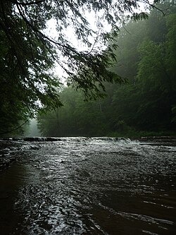
| Euclid Creek | 345 acres (140 ha) | Located in Euclid, South Euclid and Richmond Heights, was originally the site of a massive Bluestone quarry. Today, the original reservation is a sanctuary for wildlife and provides a wooded passage from the Heights area down into Euclid. As of a June, 2013 transfer of management from the state to the Park District of properties formerly part of the Cleveland Lakefront State Park, the reservation was expanded to include Euclid Beach Park and the Wildwood-Villa Angela properties with their associated marina and yacht club. [15] | Trails for hiking, horseback riding, cross country skiing and sledding hills. [13] | 1920 | map |
| Garfield Park | 213 acres (86 ha) | Located in Garfield Heights it was originally named Newburg Park dating back to 1895. In 1986, it was leased to the Metroparks system and was renamed Garfield Park. Its main feature is Mill Creek. | Trails for hiking and cross country skiing, as well as an outdoor education facility. [13] | 1986 | map |
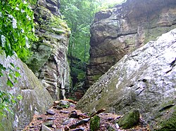
| Hinckley | 2,682 acres (1,085 ha) | Located in Hinckley Township in Medina County, the reservation is known for the famous 'Annual Return of the Buzzards' as well as Hinckley Lake and its network of glacial ledges, some of which exceed elevations of 350 feet. | Hiking and cross country skiing trails, bridle trails, boating, swimming, fishing, sledding hills, and National Audubon Society's Bird Area Program. [13] | 1920 | map |
| Huntington | 103 acres (42 ha) | Located in Bay Village on Lake Erie. It is also the location for three Metroparks affiliates: The Lake Erie Nature & Science Center and Schuele Planetarium, the Huntington Playhouse and the BAYarts community art campus. | Hiking and cross country skiing trails, fishing, outdoor education facility, sledding, swimming, and National Audubon Society's Bird Area Program. [13] | 1925 | map |
| Lakefront | 419 acres (170 ha) | Composed of previously state-run parks (Edgewater Park, Gordon Park, and the East 55th Street Marina) along the Lake Erie shoreline that the Metroparks assumed supervision of in 2013, as well as Merwin's Wharf and Wendy Park at Whiskey Island. Features include numerous beaches, boat ramps, fitness trails, fishing piers, and swimming areas. [16] | Boat ramps, trails, fishing. | 2013 | map |
| Mill Stream Run | 3,189 acres (1,291 ha) | Added to the system in 1976, this is the largest reservation in the Emerald Necklace. Mill Stream Run is situated along the east branch of the Rocky River and spanning Berea, Middleburg Heights, North Royalton and Strongsville, . | Hiking trails, cross country skiing, mountain bike trails, bridle trails, fishing, outdoor education facility, sledding, toboggan chutes and National Audubon Society's Bird Area Program. [13] | 1976 | map |
| North Chagrin | 2,140 acres (870 ha) | Located in Mayfield Village, Gates Mills and Willoughby Hills, the North Chagrin Reservation straddles Cuyahoga and Lake Counties and like its smaller neighbor to the south, follows a part of the Chagrin River. While it is the home to the historic Manakiki Golf Course, the reservation's arguably most notable man-made attraction is Squire's Castle. The North Chagrin Reservation also houses one of Northeast Ohio's only old-growth forests, the A.B. Williams Memorial Woods. [3] | Old growth forest, golf, trails, cross country skiing, fishing, golf course, North Chagrin Nature Center, sledding, and National Audubon Society's Bird Area Program. [13] [3] | 1925 | map |
| Ohio & Erie Canal | 312 acres (126 ha) | Opened in 1999 and stretching through Cuyahoga Heights and Valley View, the reservation follows a portion of the historic 309-mile Ohio and Erie Canal, as well as a section of the Cuyahoga River. Observation decks provide a view of myriad wildlife. | Trails, boating, cross country skiing, mountain bike trails, outdoor education facility, CanalWay Center, and National Audubon Society's Bird Area Program. [13] | 1999 | map |
| Rocky River | 2,572 acres (1,041 ha) | Located in Rocky River, Berea, Brook Park, Cleveland, Fairview Park, Lakewood, North Olmsted and Olmsted Township, the reservation contains the first parcel of land secured for the establishment of the Metroparks by William A. Stinchcomb—one of the points of interest in the park, in fact, is the Stinchcomb-Grohl memorial. [2] Rocky River reservation boasts three golf courses: Big Met, Little Met and Mastick Woods. Rocky River is also notable for its historically important fossil deposits in the Cleveland Shale, which include some of the best-preserved fossils of the Late Devonian fish Dunkleosteus | Golf, hiking and cross country skiing trails, boating, fishing, sledding hills, horse stables, bridle trails, Rocky River Nature Center, and a National Audubon Society Bird Area Program. [13] | 1919 | map |
| South Chagrin | 1,521 acres (616 ha) | Spanning sections of Bentleyville, Solon and Moreland Hills, the reservation follows a portion of the scenic Chagrin River and features an Arboretum, a Polo Field, as well as many trails to hike and bike. Henry Church's 1885 sculpture, Squaw Rock, is one of the park's most striking man-made features as it is carved into a large slab of sandstone adjacent the river. [17] | Trails, cross country skiing, fishing, bridle trails, outdoor education facility, sledding. [13] | 1925 | map |
| Washington | 59 acres (24 ha) | Opened in 2003, this is smallest addition to the Metroparks system. Located in Newburgh Heights, the Washington Golf Learning Center is the most notable feature of the park. | Golf, the Horticultural Center and School, athletic fields, hiking trails and fishing. [13] | 2003 | map |
| West Creek | 278 acres (113 ha) | Opened in 2006, the West Creek Reservation is one of the newest additions to the Emerald Necklace. The park recently underwent a $12 million renovation, it is now home to the Watershed Stewardship Center. [18] The park, which is home to a wide variety of wildlife, meanders along its namesake, West Creek and is located in Parma. | Trails, mountain bike trails, Watershed Stewardship Center, picnic areas. | 2006 | map |