Tremont, Cleveland

Last updated

Tremont
Cleveland City Neighborhoods - Tremont.png
Coordinates: 41°28′25″N81°41′19″W / 41.4736111°N 81.6886111°W / 41.4736111; -81.6886111
CountryUnited States
State Ohio
County Cuyahoga County
CityCleveland
Population
 (2020) [1]
  Total7,731
Demographics [1]
   White 71.2%
  Black16.9%
  Hispanic (of any race)15.6%
  Asian and Pacific Islander2.5%
  Mixed and Other9.4%
Time zone UTC-5 (EST)
  Summer (DST) UTC-4 (EDT)
ZIP Codes
44109, 44113
Area code 216
Median income [1] $46,987
Source: 2013–2017 American Community Survey 5-Year Estimates [2]
Tremont Historic District
Lemko Hall 7-10-11.jpg
Lemko Hall, at the intersection of W.11th Street and Literary Road
Location map United States Cleveland.png
Red pog.svg
USA Ohio location map.svg
Red pog.svg
Usa edcp location map.svg
Red pog.svg
LocationRoughly bounded by I-490, I-71, University Ct., W. 7th St., Starkweather Ave., Brayton, Fruit Ave. and Auburn Ave., Cleveland, Ohio
Area184.7 acres (74.7 ha)
Built1851
Architectural style Late Victorian, Cleveland Double, American Foursquare, Carpenter Gothic, Stick style
NRHP reference No. 94000719 [3]
Added to NRHPJuly 15, 1994

Tremont is a neighborhood on the West Side of Cleveland, Ohio. Listed on the National Register of Historic Places, the district sits just south of the Ohio City neighborhood. It is bounded by the Cuyahoga Valley to the north and east, MetroHealth medical center to the south, and West 25th Street and Columbus Road to the west. [4]

Contents

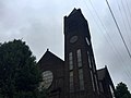
Tremont is one of Cleveland's oldest neighborhoods, and has been historically home to many different ethnic immigrant groups, including Germans, Greeks, and East Slavs. [5] It has numerous historic churches with world renowned architecture and artwork including St. Michael the Archangel (1892), Pilgrim Congregational UCC (founded in 1859), [6] St. Augustine (1893), St. John Cantius (1898), and St. Theodosius Russian Orthodox Cathedral (1912). The neighborhood has seen significant growth in recent decades and is today home to many restaurants and art galleries, and has emerged as a local cultural center, attracting technology companies with plans to further develop and preserve its historic landscape.

History

Tremont, was originally part of Brooklyn Township and from 1836 until 1854 was a section of what is now its sister neighborhood, Ohio City, when the latter was an independent town. Both were later annexed by the city of Cleveland, [5] but Tremont remained independent until 1867. During the early 1850s, the now-defunct Cleveland University briefly occupied a section of Tremont, and in fact, before being named Tremont, the neighborhood was briefly known as University Heights (not to be confused with the eastern Cleveland suburb of the same name). [7] Vestiges of the neighborhood's days as a college town remain, however, in streets with scholarly names, such as Professor, Literary, College and University. [7] The early 20th century saw an influx of East Slavic immigrants (Ukrainians, Rusyns, Russians, and Belarusians) who sought work in the steel mills in the area. [8] [9] [10] [11] By 1920, Tremont was home to over 36,000 residents. [5] However, the population had begun to steadily decline in the 1960s. With the loss of manufacturing jobs particularly in Cleveland's steel industry, culminating in the recession of the early 1980s, Tremont's population dwindled. [5] By the 2000 census there were fewer than 9,000 residents. [2]

Since the early 2000s and especially since the 2010s, Tremont has reinvented itself and is experiencing a revival. With its close proximity to downtown and affordable dwellings, the neighborhood began a revival in the 1990s due in large part to an influx of new residents, including young professionals, empty nesters, hipsters and immigrants attracted to the neighborhood's amenities, historic housing stock and new infill housing. [12] Tremont has become a destination spot with numerous shops and art galleries, as well as restaurants, bars, and bistros, such as Iron Chef Michael Symon's Lolita, which closed in 2016 due to fire damage. [13] Walkabout Tremont occurs on the 2nd Friday of each month. [14]

Points of interest

Neighborhood landmarks

Duck Island

Bisected by Abbey Avenue, Duck Island is a popular sub-neighborhood within Tremont. It is bounded by Carnegie Avenue to the north, the RTA Red Line to the west, Scranton Road to the east, and Train Avenue to the south. It is not a physical island and it has "nothing whatsoever to do with ducks." [18] The name is said to have entered common usage in Cleveland during Prohibition when Duck Island became "a place where bootleggers would 'duck' the law." [18]

Education

Related Research Articles

<span class="mw-page-title-main">Cleveland</span> City and county seat of Cuyahoga County, Ohio, United States

Cleveland, officially the City of Cleveland, is a city in the U.S. state of Ohio and the county seat of Cuyahoga County. Located in Northeast Ohio along the southern shore of Lake Erie, it is situated across the U.S. maritime border with Canada and lies approximately 60 miles (97 km) west of Pennsylvania.

<span class="mw-page-title-main">Lemkos</span> East Slavic ethnic group inhabiting parts of South-Eastern Poland and Western Ukraine.

Lemkos are an ethnic group inhabiting the Lemko Region of Carpathian Rus', an ethnographic region in the Carpathian Mountains and foothills spanning Ukraine, Slovakia and Poland.

<span class="mw-page-title-main">University Circle</span> Neighborhood of Cleveland, Ohio, United States

University Circle is a district in the neighborhood of University on the East Side of Cleveland, Ohio. It is home to the Cleveland Museum of Art, Severance Hall, the Cleveland Institute of Art, Case Western Reserve University, the Cleveland Institute of Music, the Museum of Contemporary Art Cleveland; the Cleveland Botanical Garden; historic Lake View Cemetery; the Cleveland Museum of Natural History; and University Hospitals/Case Medical Center.

<span class="mw-page-title-main">Downtown Cleveland</span> Central business district of Cleveland, Ohio, United States

Downtown Cleveland is the central business district of Cleveland, Ohio. The economic and symbolic center of the city and the Cleveland-Akron-Canton, OH Combined Statistical Area, it is Cleveland's oldest district, with its Public Square laid out by city founder General Moses Cleaveland in 1796.

<span class="mw-page-title-main">Broadway–Slavic Village</span> Neighborhood of Cleveland, Ohio, United States

Broadway–Slavic Village is a neighborhood on the Southeast side of Cleveland, Ohio. One of the city's oldest neighborhoods, it originated as the township of Newburgh, first settled in 1799. Much of the area has historically served as home to Cleveland's original Czech and Polish immigrants. While demographics have shifted over the decades, the largest part of Broadway today, Slavic Village, is named for these earlier communities.

<span class="mw-page-title-main">Ukrainian Village, Chicago</span> Neighborhood in Chicago, Illinois

Ukrainian Village is a Chicago neighborhood located on the near west side of Chicago. Its boundaries are Division Street to the north, Grand Avenue to the south, Western Avenue to the west, and Damen Avenue to the east. It is one of the neighborhoods in the West Town community area, and has one of the largest concentrations of Ukrainians in the United States.

<span class="mw-page-title-main">Ukrainian Catholic Eparchy of Saint Josaphat in Parma</span> Ukrainian Greek Catholic ecclesiastical jurisdiction in the United States

Ukrainian Catholic Eparchy of Saint Josaphat in Parma is a Ukrainian Greek Catholic Church ecclesiastical jurisdiction or eparchy of the Catholic Church in the United States. Its episcopal see is Parma, Ohio. It was established in 1983 by Pope John Paul II. The eparchy encompasses parishes in Florida, Georgia, North Carolina, Ohio, western Pennsylvania, Tennessee, and West Virginia. The Eparchy of Saint Josaphat in Parma is a suffragan eparchy in the ecclesiastical province of the metropolitan Archeparchy of Philadelphia.

<span class="mw-page-title-main">St. Michael the Archangel Church (Cleveland, Ohio)</span> Historic church in Ohio, United States

St. Michael the Archangel is a Roman Catholic church located at 3114 Scranton Road in the Tremont neighborhood on the west side of Cleveland, Ohio. The church is named in honor of St. Michael the Archangel and was completed in 1892.

<span class="mw-page-title-main">St. Theodosius Russian Orthodox Cathedral</span> Eastern Orthodox cathedral in Ohio, United States

St. Theodosius Cathedral is an Eastern Orthodox church located on Starkweather Avenue in the West Side neighborhood of Tremont in Cleveland, Ohio. Considered one of the finest examples of Russian church architecture in the United States, it is listed on the National Register of Historic Places. St. Theodosius was the first Eastern Orthodox parish in Cleveland and is currently under the jurisdiction of the Diocese of the Midwest of the Orthodox Church in America. The cathedral is perhaps best known for its appearance in the 1978 Best Picture-winning film, The Deer Hunter, with Robert De Niro, Christopher Walken, and Meryl Streep. It is also seen in the opening credits of Major League.

<span class="mw-page-title-main">St. Clair–Superior</span> Neighborhood of Cleveland, Ohio, United States

St. Clair–Superior is a neighborhood on the East Side in Cleveland, Ohio, in the United States. Largely settled in the 1880s and 1890s by Eastern European immigrants, white flight in the 1990s left the neighborhood largely African American. It is one of the oldest and most culturally diverse neighborhoods in Cleveland today.

<span class="mw-page-title-main">Jefferson, Cleveland</span> Neighborhood of Cleveland, Ohio, United States

Jefferson is a neighborhood on the West Side of Cleveland, Ohio. It is bounded by the neighborhoods of West Boulevard and Cudell and the village of Linndale to the east, Bellaire–Puritas to the south, Kamm's Corners to the west, and the streetcar suburb of Lakewood to the north. It is one of four sub-neighborhoods that comprise the larger historical neighborhood of West Park, the others being Kamm's Corners, Bellaire–Puritas, and Hopkins.

Andrej Bicenko also spelled Andrei Bicenko, Andrey Bitsenko was a well-known Russian fresco painter who spent the early part of his career in Serbia. When Yugoslavia fell to the communists at the end of World War II, he emigrated to the United States of America where he continued painting Orthodox churches, including St. Theodosius Russian Orthodox Cathedral in Cleveland, Ohio.

<span class="mw-page-title-main">Pilgrim Congregational Church (Cleveland, Ohio)</span> Historic church in Ohio, United States

Pilgrim Congregational Church is a historic congregation of the United Church of Christ in Cleveland, Ohio, United States. Constructed in the 1890s for a congregation founded in the 1850s, it was named a historic site in the 1970s.

<span class="mw-page-title-main">Cuyahoga Valley, Cleveland</span> Neighborhood of Cleveland, Ohio, United States

Cuyahoga Valley is a neighborhood on the Central and South Side of Cleveland, Ohio, located along the Cuyahoga River. Formerly known as Industrial Valley, the neighborhood was originally limited to only one section of the geographic Cuyahoga River Valley, but the city expanded it in 2012 to include the entire valley area. The present neighborhood includes the Flats and extends from the peninsula of Whiskey Island on Lake Erie in the north to the borders of the suburbs of Newburgh Heights and Cuyahoga Heights in the south. To the east, it borders Downtown Cleveland and the neighborhoods of Broadway–Slavic Village and Central. To the west, it borders the neighborhoods of Detroit–Shoreway, Ohio City, Tremont, and Brooklyn Centre.

<span class="mw-page-title-main">Clark–Fulton</span> Neighborhood of Cleveland, Ohio, United States

Clark–Fulton is a neighborhood on the West Side of Cleveland, Ohio. It is bounded by Ohio City to the north, Tremont to the east, Brooklyn Centre to the south, and Stockyards on the west. The neighborhood, which covers about one square mile, is Cleveland's most densely populated community. In recent years, the neighborhood has begun calling itself La Villa Hispaña due to its large Hispanic population, Puerto Rican and otherwise. The community is focused on advancing and promoting Hispanic-owned businesses and cultural activities.

<span class="mw-page-title-main">Demographics of Cleveland</span>

The demographics of Cleveland have fluctuated throughout the city's history. From its founding in 1796, the city's population grew to 261,353 by 1890, and to 796,841 by 1920, making it the fifth largest city in the United States at the time. By 1930, the population rose to 900,429 and, after World War II, it reached 914,808. Due to various historical factors including deindustrialization, suburbanization, and urban sprawl, Cleveland's population began decreasing in the 1960s. By 1970, the city's population was 750,903. By 1980, it was 573,822 and it had lost its position as one of the top 10 largest cities in the U.S. By 2020, the population had further fallen to 372,624. Beginning in 2018, the city's population began to flatten, after decades of decline. Additionally, between 2010 and 2020, several neighborhoods within Cleveland saw a significant population increase, most notably Downtown, but also University Circle and several West Side neighborhoods.

<span class="mw-page-title-main">History of the Jews in Greater Cleveland</span>

The Jewish community of the Greater Cleveland area comprises a significant ethnoreligious population of the U.S. State of Ohio. It began in 1839 by immigrants from Bavaria and its size has significantly grown in the decades since then. In the early 21st century, Ohio's census data reported over 150,000 Jews, with the Cleveland area being home to more than 50% of this population. As of 2018, Greater Cleveland is the 23rd largest Jewish community in the United States. As of 2023, the Cleveland Jewish Community is estimated to be about 100,000 people.

The Cleveland Landmarks Commission is responsible for determining whether buildings, sites or historic districts are eligible for designation as landmarks in the city of Cleveland, Ohio. As Cleveland has many historic streets, districts, and buildings the commission is charged with weeding out what buildings, districts, and streets are of definite interest to the people of Cleveland, Ohio and the nation of the United States in general. Two of the oldest buildings in the city that are listed on the Landmarks Commission are the 1824 Dunham Tavern Museum and the 1855 Old Stone Church located on Public Square.

<span class="mw-page-title-main">West Boulevard</span> Neighborhood of Cleveland, Ohio, United States

West Boulevard is a neighborhood on the West Side of Cleveland, Ohio. It borders the suburbs of Brooklyn and Linndale to the south, Interstate 90 and the neighborhoods of Cudell and Detroit–Shoreway to the north, Stockyards to the east, and Jefferson to the west. Its name is derived "from the West Blvd. thoroughfare which runs north-south through the district’s center."

<span class="mw-page-title-main">Mount Pleasant, Cleveland</span> Neighborhood of Cleveland, Ohio, United States

Mount Pleasant is a neighborhood on the East Side of Cleveland, Ohio. It borders the neighborhoods of Buckeye–Shaker and Buckeye–Woodhill to the north, Kinsman to the west, Union–Miles Park to the south, and the suburb of Shaker Heights and the Lee–Harvard neighborhood of Cleveland's Lee–Miles area to the east. The neighborhood has been home to numerous ethnic groups, first Manx immigrants, then Germans, Czechs, Russians, Jews, and Italians. Today, it is a predominantly African American neighborhood. Together with Buckeye–Shaker, it is politically part of Cleveland's Ward 4.

References

  1. 1 2 3 "Cleveland Neighborhoods and Wards: Tremont Neighborhood Factsheet (2021)" (PDF). The Center for Community Solutions (Cleveland). Retrieved June 3, 2022.
  2. 1 2 "Population Metrics: Tremont". Progress Index Cleveland. Cleveland Neighborhood Progress. Retrieved April 18, 2020.
  3. "National Register Information System". National Register of Historic Places . National Park Service. July 9, 2010.
  4. "Tremont West Development Corporation: Location" . Retrieved May 7, 2013.
  5. 1 2 3 4 "Tremont". The Encyclopedia of Cleveland History. Case Western Reserve University . Retrieved June 12, 2019.
  6. "Pilgrim Church" . Retrieved September 8, 2009.
  7. 1 2 "Cleveland University". The Encyclopedia of Cleveland History. Case Western Reserve University . Retrieved June 24, 2020.
  8. "Ukrainians". The Encyclopedia of Cleveland History. Case Western Reserve University . Retrieved June 24, 2020.
  9. "Rusyns". The Encyclopedia of Cleveland History. Case Western Reserve University . Retrieved June 24, 2020.
  10. "Russians". The Encyclopedia of Cleveland History. Case Western Reserve University . Retrieved June 24, 2020.
  11. "Belarusians". The Encyclopedia of Cleveland History. Case Western Reserve University . Retrieved June 24, 2020.
  12. Wren, Patricia (November 30, 2008). "Tremont is an artsy, lively neighborhood with great rental opportunities". The Plain Dealer . Cleveland. Retrieved July 12, 2011.
  13. Crea, Joe (January 10, 2016). "Michael Symon says Lolita fire damage appears 'significant,' vows to rebuild". The Plain Dealer . Cleveland. Retrieved July 20, 2021.
  14. "Walkabout Tremont: Second Friday of every month, year-round". Destination Cleveland. Retrieved June 24, 2020.
  15. Rotman, Michael; Dubelko, Jim. "St. Theodosius Cathedral". Cleveland Historical. Retrieved June 24, 2020.
  16. "St. Theodosius Russian Orthodox Cathedral". The Encyclopedia of Cleveland History. Case Western Reserve University. July 30, 2019. Retrieved June 24, 2020.
  17. "Handle With Care". Cleveland Magazine . Great Lakes Publishing. 36: 128–196. November 2006.
  18. 1 2 Roy, Chris. "Duck Island". Cleveland Historical. Retrieved July 20, 2021.

Further reading