Collinwood

Last updated
Collinwood
Collinwood.jpg
Cleveland City Neighborhoods - North Shore Collinwood.png
Cleveland City Neighborhoods - Collinwood-Nottingham.png
CountryUnited States
State Ohio
County Cuyahoga
City Cleveland
Population
 (2020)
  Total15,780 (North Shore Collinwood) [1]
10,785 (Collinwood–Nottingham) [2]
Demographics (North Shore Collinwood)
[1]
   White 29.9%
  Black63%
  Hispanic (of any race)1.1%
  Asian and Pacific Islander0.1%
  Mixed and Other6.9%
Demographics (Collinwood–Nottingham)
[2]
  White10.9%
  Black84.2%
  Hispanic (of any race)1.4%
  Asian and Pacific Islander0.4%
  Mixed and Other4.6%
Time zone UTC-5 (EST)
  Summer (DST) UTC-4 (EDT)
ZIP Codes
44110, 44119
Area code 216
Median income $27,935 (North Shore Collinwood) [1]
$26,404 (Collinwood–Nottingham) [2]
Source: 2020 U.S. Census, City Planning Commission of Cleveland. [1] [2]

Collinwood is a historical area in the northeast part of Cleveland, Ohio. Originally a village in Euclid Township, it was annexed by the city in 1910. Collinwood grew around the rail yards of the Lake Shore and Michigan Southern Railway (now CSX) and is divided by these same tracks into the neighborhoods of North Shore Collinwood and Collinwood–Nottingham. Collinwood was identified as one of America's Best Secret Neighborhoods by Travel + Leisure in 2008. [3]

Contents

History

The neighborhood's most infamous incident antedates its annexation by Cleveland. On Ash Wednesday, March 4, 1908, Collinwood was the site of an event known as the Collinwood School Fire, at Lakeview Elementary School. [4] One of the deadliest school fires in American history, 172 children, two young teachers, and one rescuer died in the fire after being trapped in stairwell vestibules. Originally, the students were thought to be trapped because doors to the school opened inward, but the coroner's report indicated that the doors did indeed open outward. While some of the children died from burns and smoke inhalation, most were either crushed or suffocated in the frantic attempt to escape the building. Those killed in the fire who could not be identified were buried in a mass grave in Cleveland's Lakeview Cemetery. National building standards requiring that doors in public buildings open outward were already in effect, and the fire did result in a trend towards municipalities nationwide adopting policies of school inspections and enforcing stricter building codes. [4]

Annexed by Cleveland in 1912, portions of the Village of Nottingham were rolled into Collinwood.

For much of the 20th century, Collinwood thrived due in large part to heavy industry. Besides the railroad yards, major corporations such as General Motors, which operated its Fisher Body plant on Coit Road and General Electric with its Pitney Glass Works on E. 152nd., employed thousands of workers. [5] [6] By the eve of World War II, Collinwood's economic vitality had drawn large numbers of both ethnic white Europeans and Southern Appalachians. The 1960s had an influx of African Americans, who are today the majority population both in North and South Collinwood.

Collinwood took national center stage in the 1970s during a gang war when the Cleveland Mafia, centered in the Collinwood and Murray Hill neighborhoods, fought a territorial war with the Celtic Club led by Irish gangster Danny Greene. The eventual bombing death of Greene brought the federal organized-crime task force to Cleveland, which after many trials, is said to have crippled the Mafia in Cleveland.

In the 21st century, Collinwood has become a place of interest for artists seeking low-cost urban places to live and work. The housing and foreclosure crisis, though somewhat detrimental to the urban fabric of the neighborhood, has provided opportunities for artists to acquire properties very inexpensively. A collective known as Arts Collinwood has been instrumental in helping to revitalize the Waterloo Road business district on the north side of the neighborhood. [7]

North Shore Collinwood

Begun mainly as the residential section, North Shore Collinwood, commonly known as North Collinwood, is bounded roughly between E. 133rd Street to the west and E. 185th Street to the northeast (E.200th street due east), and between Lake Erie to the north and the Collinwood Railroad Yards and tracks (currently operated by CSX to the south, Woodworth Avenue to the southwest, and roughly Roseland Avenue to the southeast. [8] [9] North Collinwood is the location of several parks, including Wildwood Park and Marina, East Shore Park, and Beachland Park, and was the site of historic Euclid Beach Park. The Roman Catholic Villa Angela-St. Joseph High School is located at E. 185th and Lakeshore Boulevard.

Collinwood–Nottingham

What was once the industry-heavy of the two sections, Collinwood–Nottingham, commonly known as South Collinwood, is roughly bounded between E. 134th Street on the west and Euclid Creek on the east, the Collinwood Railroad Yards and tracks to the north, Woodworth Avenue to the southwest, and roughly Roseland Avenue to the southeast. [10] The location of the Five Points, where Ivanhoe Road, St. Clair Avenue, and E. 152nd Street intersect, is the central business district of the neighborhood, and is also the location of Collinwood High School, whose sports teams are aptly named the Railroaders. [11] Although today it is largely African American, South Collinwood has historically been an enclave of European immigrants, as well as migrants from the Southern United States.

South Collinwood at one time was home to large concentrations of Eastern Europeans, and in particular, a large Slovenian community. The boyhood home to eventual Cleveland mayor and Ohio governor and senator, George Voinovich, the Slovenian neighborhood was centered on St. Mary of the Assumption Church, and the Slovenian Home, both located on Holmes Avenue. [12] Slovenian Polka King Frankie Yankovic, a South Collinwood native, played live polka music in many of the taverns and dance halls in the area.

Italians, many of whom had settled the neighborhood after relocating from the Central neighborhood's Big Italy district, also settled heavily in the area, mainly along its southern border. [11] The Italian Village, with a population of Italian descendants greater than that of Cleveland's Little Italy neighborhood, became well known for its Feast of St. Anthony, held every June and the Feast of the Assumption, held every August at Holy Redeemer Catholic Church on Kipling Avenue.

Its American immigrants, many relocated Southerners – mostly from Tennessee, West Virginia, and Kentucky – began arriving in the 1940s to work in the factories. Mainly they settled along the western edge of the neighborhood, especially along the E. 140th section; many bars in that area featured live country music and Southern food.

South Collinwood was once the headquarters for the Jordan Motor Car Company when it produced cars from 1916–1931. The plant was located at 1070 E. 152 St. Cleveland, where the Collinwood athletic complex stands today.

Notable residents

See also

Related Research Articles

<span class="mw-page-title-main">Cleveland</span> City in Ohio, United States

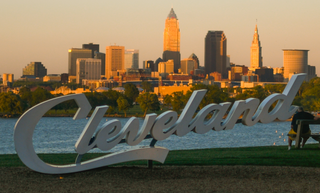
Cleveland, officially the City of Cleveland, is a city in and the county seat of Cuyahoga County, Ohio, United States. Located in Northeast Ohio along the southern shore of Lake Erie, it is situated across the U.S. maritime border with Canada and lies approximately 60 miles (97 km) west of Pennsylvania.

<span class="mw-page-title-main">Euclid, Ohio</span> City in Ohio, United States

Euclid is a city in Cuyahoga County, Ohio, United States. It is an inner ring suburb of Cleveland. The population was 49,692 at the 2020 census, making it the fourth largest city in Cuyahoga County, behind Cleveland, Parma and Lakewood.

<span class="mw-page-title-main">George Voinovich</span> American politician (1936–2016)

George Victor Voinovich was an American politician who served as a United States senator from Ohio from 1999 to 2011, the 65th governor of Ohio from 1991 to 1998 and the 54th mayor of Cleveland from 1980 to 1989, the last Republican to serve in that office.
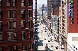
<span class="mw-page-title-main">Downtown Cleveland</span> Central business district of Cleveland, Ohio, United States

Downtown Cleveland is the central business district of Cleveland, Ohio. The economic and symbolic center of the city and the Cleveland-Akron-Canton, OH Combined Statistical Area, it is Cleveland's oldest district, with its Public Square laid out by city founder General Moses Cleaveland in 1796.

The Cleveland Short Line Railway is a freight bypass around southern Cleveland, Ohio, in the United States. A quasi-independent railroad organized by major shareholders of the Lake Shore and Michigan Southern Railway, the shortline was intended to allow the Lake Shore and Michigan Southern to bypass the congested railroads in downtown Cleveland. The Cleveland Short Line has had a succession of owners, and is currently part of CSX Transportation.

Michael D. Polensek is a City Council member in Cleveland, Ohio, representing Ward 8. He has served in Cleveland City Council since 1977. He lives in the North Shore Collinwood area of Cleveland with his wife, Kathy, and has five children: Lisa, Deana, Michael, Lauren and Andrew.

The National Cleveland-Style Polka Hall of Fame and Museum is a museum in Euclid, Ohio, United States. It traces the history of the Cleveland-style polka, from its Slovenian roots from the 19th century, through American factory and mining towns where it absorbed jazz and country expressions, to the post-war years when top ten polka hits got the nation on the dance floor.

Collinwood High School is a public high school located in the Collinwood neighborhood on the east side of Cleveland, Ohio, United States. It is part of the Cleveland Metropolitan School District. The school is divided into three academies: Advanced Placement Academy, STEM Teaching Professions Academy, and Academy of Interior and Fashion Design.

<span class="mw-page-title-main">Glenville, Cleveland</span> Neighborhood of Cleveland, Ohio, United States

Glenville is a neighborhood on the East Side of Cleveland, Ohio. To the north, it borders the streetcar suburb of Bratenahl, the Cleveland Memorial Shoreway, and the Lake Erie shore, encompassing the Cleveland Lakefront Nature Preserve. To the east, it borders the suburb of East Cleveland, and to the south, it borders the neighborhoods of Hough and University Circle. Glenville borders the Collinwood area to the northeast at East 134th Street, and St. Clair–Superior to the west at Martin Luther King Jr. Boulevard and the Cleveland Cultural Gardens in Rockefeller Park.

<span class="mw-page-title-main">St. Clair–Superior</span> Neighborhood of Cleveland, Ohio, United States

St. Clair–Superior is a neighborhood on the East Side in Cleveland, Ohio, in the United States. Largely settled in the 1880s and 1890s by Eastern European immigrants, white flight in the 1990s left the neighborhood largely African American. It is one of the oldest and most culturally diverse neighborhoods in Cleveland today.

<span class="mw-page-title-main">105th and Euclid</span>

East 105th Street and Euclid Avenue was at one time the most famous intersection in the city of Cleveland, Ohio. The legendary commercial junction consists of several blocks from East to West between 107th Street and 105th Street.

<span class="mw-page-title-main">Hough, Cleveland</span> Neighborhood of Cleveland, Ohio, United States

Hough is a neighborhood situated on the East Side of Cleveland, Ohio. Roughly two square miles, the neighborhood is bounded to Superior and Euclid Avenue between East 55th and East 105th streets. Placed between Downtown Cleveland and University Circle, Hough borders Fairfax and Cedar–Central to the South and Glenville and St. Clair–Superior to the North. The neighborhood became a target for revitalization during the mid-20th century, after the 1966 Hough Riots.

The Village of Nottingham, Ohio was located in Euclid Township, Cuyahoga County, Ohio. It was one of a string of villages along the railroad running east from Cleveland, Ohio. Nottingham was annexed into Cleveland in 1912.

<span class="mw-page-title-main">Timeline of Cleveland</span> Timeline of Cleveland, Ohio, United States

This article is a timeline of the history of the city of Cleveland, Ohio, USA.

<span class="mw-page-title-main">Fairfax, Cleveland</span> Neighborhood of Cleveland, Ohio, United States

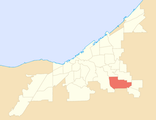
Fairfax is a neighborhood on the East Side of Cleveland, Ohio. It is roughly bounded between Euclid Avenue to the north, Woodland Avenue to the south, E. 71st Street to the west and E. 105th Street to the east. Fairfax is located on the edge of University Circle, an area containing Cleveland's major educational institutions and museums. The Karamu House is on the National Register of Historic places and is the nation's oldest African-American theater. The northeastern quadrant of Fairfax, along Euclid Avenue to 105th Street, is dominated by the Cleveland Clinic.

The Beachland Ballroom and Tavern is a music venue located in the Collinwood neighborhood of Cleveland, Ohio, United States. It was founded by Cindy Barber and Mark Leddy.

<span class="mw-page-title-main">West Park, Cleveland</span> Historical area of Cleveland, Ohio, United States

West Park is a historical area on the West Side of Cleveland, Ohio. Once an independent municipality, it was annexed by Cleveland after a referendum in 1923. The area covers 12.5 square miles and is bounded by West 117th Street to the east, the Rocky River Valley to the west, Brookpark Road to the South, and the streetcar suburb of Lakewood to the north. The Cleveland City Planning Commission traditionally divides West Park into four neighborhoods: Jefferson, Kamm's Corners, Bellaire–Puritas, and Hopkins.

<span class="mw-page-title-main">Union–Miles Park</span> Neighborhood of Cleveland, Ohio, United States

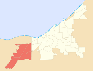
Union–Miles Park is a neighborhood on the Southeast side of Cleveland, Ohio, in the United States. The neighborhood draws its name from Union Avenue, and Miles Park in its far southwest corner.

<span class="mw-page-title-main">Euclid–Green</span> Neighborhood of Cleveland, Ohio, United States

Euclid–Green is a neighborhood on the Northeast side of Cleveland, Ohio. It is "shaped somewhat like an isosceles triangle" and is bounded by the neighborhood of Collinwood–Nottingham to the northwest, the suburb of Euclid to the northeast, and the suburbs of South Euclid, Cleveland Heights, and East Cleveland to the south.

The history of Slovenes in Cleveland began in the 19th century, peaking between the late 19th and early 20th century with massive emigration of Slovenes prior to World War I. Slovenes in the Cleveland metropolitan area make up the largest Slovene diaspora in the United States. Since Slovene immigrants began to settle in Cleveland in the 1880s, Cleveland has become home to the largest population of Slovenes in the world outside of Slovenia. Until Slovene independence in 1990, the Slovene consulate in Cleveland served as an official consulate for Yugoslavia under Tito.

References

  1. 1 2 3 4 "Cleveland Neighborhoods and Wards: North Shore Collinwood Neighborhood Factsheet (2021)" (PDF). The Center for Community Solutions (Cleveland). Retrieved June 11, 2022.
  2. 1 2 3 4 "Cleveland Neighborhoods and Wards: Collinwood–Nottingham Neighborhood Factsheet (2021)" (PDF). The Center for Community Solutions (Cleveland). Retrieved June 11, 2022.
  3. "Collinwood, Cleveland, OH" . Retrieved 26 June 2017.
  4. 1 2 "Encyclopedia of Cleveland History:COLLINWOOD SCHOOL FIRE". Ech.case.edu. Retrieved 2012-11-08.
  5. "Encyclopedia of Cleveland History:GENERAL ELECTRIC CO". Ech.case.edu. Retrieved 2012-11-08.
  6. "Encyclopedia of Cleveland History:FISHER BODY DIVISION OF GENERAL MOTORS CORP". Ech.case.edu. Retrieved 2012-11-08.
  7. Alter, Alexandra (April 17, 2009). "Artists vs. Blight". The Wall Street Journal.
  8. "City of Cleveland Planning Commission: Map of North Collinwood". Archived from the original on 22 March 2012. Retrieved 26 June 2017.
  9. "North Collinwood". Progressiveurban.com. Retrieved 2012-11-08.
  10. "City of Cleveland Planning Commission: Map of South Collinwood". Archived from the original on 22 March 2012. Retrieved 26 June 2017.
  11. 1 2 "Community: Collinwood". cleveland. Archived from the original on 2012-10-14. Retrieved 2012-11-08.
  12. "History - Church of Saint Mary of the Assumption". Stmaryscollinwood.com. Retrieved 2012-11-08.
  13. Atassi, Leila (January 16, 2017). "The rise, fall and redemption of Cleveland mayoral candidate and City Councilman Jeff Johnson". The Plain Dealer . Retrieved January 17, 2017.

Coordinates: 41°33′29″N81°34′08″W / 41.558°N 81.569°W / 41.558; -81.569