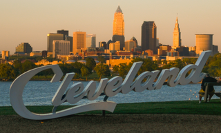
Cleveland, officially the City of Cleveland, is a city in the U.S. state of Ohio and the county seat of Cuyahoga County. Located in Northeast Ohio along the southern shore of Lake Erie, it is situated across the U.S. maritime border with Canada and lies approximately 60 miles (97 km) west of Pennsylvania. Cleveland ranks as the most populous city on Lake Erie, the second-most populous city in Ohio, and the 54th-most populous city in the U.S. with a 2020 population of 372,624. The city anchors the Cleveland metropolitan area, the 33rd-largest in the U.S. at 2.18 million residents, as well as the larger Cleveland–Akron–Canton combined statistical area, the most populous in Ohio and the 17th-largest in the country with a population of 3.63 million in 2020.

Lakewood is a city in Cuyahoga County, Ohio, United States, on the southern shore of Lake Erie. Established in 1889, it is one of Cleveland's historical streetcar suburbs and part of the Cleveland metropolitan area. The population was 50,942 at the 2020 census, making it the third largest city in Cuyahoga County, behind Cleveland and Parma.

Shaker Heights is a city in Cuyahoga County, Ohio, United States. As of the 2020 census, the city's population was 29,439. Shaker Heights is an inner-ring streetcar suburb of Cleveland, abutting the eastern edge of the city's limits. It is a planned community developed by the Van Sweringen brothers, railroad moguls who envisioned the community as a suburban retreat from the industrial inner city of Cleveland.

The mayor of Cleveland is the head of the executive branch of government of the City of Cleveland, Ohio. As the chief executive in Cleveland's mayor–council system, the mayor oversees all city services and is "responsible for enforcing the city charter, city ordinances, and the laws of the State of Ohio." The mayor's office is located at Cleveland City Hall at 601 Lakeside Avenue in Downtown Cleveland. Since 1836, the city has had a total of 54 mayors, including the city's current mayor, Justin Bibb, encompassing 58 mayoral administrations, as four mayors have served in non-consecutive terms.

University Circle is a district in the neighborhood of University on the East Side of Cleveland, Ohio. It is home to the Cleveland Museum of Art, Severance Hall, the Cleveland Institute of Art, Case Western Reserve University, the Cleveland Institute of Music, the Museum of Contemporary Art Cleveland; the Cleveland Botanical Garden; historic Lake View Cemetery; the Cleveland Museum of Natural History; and University Hospitals/Case Medical Center.

Downtown Cleveland is the central business district of Cleveland, Ohio, United States. The economic and cultural center of the city and the Cleveland metropolitan area, it is Cleveland's oldest district, with its Public Square laid out by city founder General Moses Cleaveland in 1796.

Old Brooklyn is a neighborhood on the West Side of Cleveland, Ohio, United States, located approximately five miles south of downtown Cleveland. It extends east-to-west from the Cuyahoga River to the city of Brooklyn and north-to-south from the Brookside Park Valley to the city of Parma. It is home to the Cleveland Metroparks, including the Cleveland Zoo; the Jesse Owens tree at James Ford Rhodes High School; and the Benjamin Franklin Community Garden, the largest urban community garden in Cuyahoga County. Old Brooklyn has recently adopted the slogan "Old Brooklyn, a great place to grow" to commemorate its history and potential growth.

The written history of Cleveland began with the city's founding by General Moses Cleaveland of the Connecticut Land Company on July 22, 1796. Its central location on the southern shore of Lake Erie and the mouth of the Cuyahoga River allowed it to become a major center for Great Lakes trade in northern Ohio in the early 19th century. An important Northern city during the American Civil War, Cleveland grew into a major industrial metropolis and a gateway for European and Middle Eastern immigrants, as well as African American migrants, seeking jobs and opportunity.
Buckeye–Shaker is a neighborhood on the East Side of Cleveland, Ohio. It encompasses two sub neighborhoods: in its south and west, the old Buckeye neighborhood; and in its northeast, the Shaker Square neighborhood, which is centered on an historic shopping district and an eponymous rapid transit station, located at the intersection of Shaker and Moreland Boulevards, on the light rail line that connects the city of Shaker Heights to downtown Cleveland. From the early to mid-20th century, the Buckeye Road neighborhood was known as "Little Hungary", serving as the historic heart of Cleveland's Hungarian community, which at one time was the largest in the world outside of Hungary and for years has been almost completely African-American. Shaker Square, continues to be known as one of Cleveland's most notable neighborhoods, in terms of shopping, dining, architecture, the education of its residents, participation in civic life, diversity, and quality of living.

Broadway–Slavic Village is a neighborhood on the Southeast side of Cleveland, Ohio. One of the city's oldest neighborhoods, it originated as the township of Newburgh, first settled in 1799. Much of the area has historically served as home to Cleveland's original Czech and Polish immigrants. While demographics have shifted over the decades, the largest part of Broadway today, Slavic Village, is named for these earlier communities.
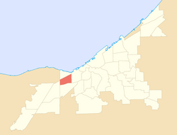
West Boulevard–Cudell station is a station on the RTA Red Line in Cleveland, Ohio. The station is located on the north side of Detroit Avenue at the intersection with West Boulevard in Cleveland's Cudell neighborhood.

Jefferson is a neighborhood on the West Side of Cleveland, Ohio. It is bounded by the neighborhoods of West Boulevard and Cudell and the village of Linndale to the east, Bellaire–Puritas to the south, Kamm's Corners to the west, and the streetcar suburb of Lakewood to the north. It is one of four sub-neighborhoods that comprise the larger historical neighborhood of West Park, the others being Kamm's Corners, Bellaire–Puritas, and Hopkins.

Tremont is a neighborhood on the West Side of Cleveland, Ohio. Listed on the National Register of Historic Places, the district sits just south of the Ohio City neighborhood. It is bounded by the Cuyahoga Valley to the north and east, MetroHealth medical center to the south, and West 25th Street and Columbus Road to the west.

Hough is a neighborhood situated on the East Side of Cleveland, Ohio. Roughly two square miles, the neighborhood is bounded to Superior and Euclid Avenue between East 55th and East 105th streets. Placed between Downtown Cleveland and University Circle, Hough borders Fairfax and Cedar–Central to the South and Glenville and St. Clair–Superior to the North. The neighborhood became a target for revitalization during the mid-20th century, after the 1966 Hough Riots.

Cuyahoga Valley is a neighborhood on the Central and South Side of Cleveland, Ohio, located along the Cuyahoga River. Formerly known as Industrial Valley, the neighborhood was originally limited to only one section of the geographic Cuyahoga River Valley, but the city expanded it in 2012 to include the entire valley area. The present neighborhood includes the Flats and extends from the peninsula of Whiskey Island on Lake Erie in the north to the borders of the suburbs of Newburgh Heights and Cuyahoga Heights in the south. To the east, it borders Downtown Cleveland and the neighborhoods of Broadway–Slavic Village and Central. To the west, it borders the neighborhoods of Detroit–Shoreway, Ohio City, Tremont, and Brooklyn Centre.

The demographics of Cleveland have fluctuated throughout the city's history. From its founding in 1796, Cleveland's population grew to 261,353 by 1890, and to 796,841 by 1920, making it the fifth largest city in the United States at the time. By 1930, the population rose to 900,429 and, after World War II, it reached 914,808. Due to various historical factors including deindustrialization, suburbanization, and urban sprawl, Cleveland's population began decreasing in the 1960s. By 1970, the city's population was 750,903. By 1980, it was 573,822 and it had lost its position as one of the top 10 largest cities in the U.S. By 2020, the population had further fallen to 372,624. Beginning in 2018, the city's population began to flatten, after decades of decline. Additionally, between 2010 and 2020, several neighborhoods within Cleveland saw a significant population increase, most notably Downtown, but also University Circle and several West Side neighborhoods.

Edgewater is a neighborhood on the West Side of Cleveland, Ohio. Located along the Lake Erie shoreline, it is situated approximately five miles west of downtown Cleveland. It extends east-to-west from the neighborhood of Detroit–Shoreway to the streetcar suburb of Lakewood and north-to-south from Lake Erie to the neighborhood of Cudell.

Stockyards, colloquially the Stockyards or simply the Yards, is a neighborhood on the West Side of Cleveland, Ohio. It is located between I-71 to the south, roughly Ridge Road to the west, West 44th Street to the east, and just south of I-90 to the north. The neighborhood has been historically home to significant communities of Hungarians and Czechs, and since the 1980s, it has also been home to a growing Hispanic community.

Hopkins is a neighborhood on the West Side of Cleveland, Ohio. Known as Riverside until 2014, it borders the neighborhoods of Kamm's Corners and Bellaire–Puritas to the north and northeast, the suburb of Fairview Park to the northwest, and Brook Park to the south, east, and west. Most of the area of Hopkins is covered by Cleveland Hopkins International Airport. Consequently, the neighborhood has "one of Cleveland's lowest population levels as well as the lowest level of population density."

West Boulevard is a neighborhood on the West Side of Cleveland, Ohio. It borders the suburbs of Brooklyn and Linndale to the south, Interstate 90 and the neighborhoods of Cudell and Detroit–Shoreway to the north, Stockyards to the east, and Jefferson to the west. Its name is derived "from the West Blvd. thoroughfare which runs north-south through the district’s center."
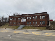 The B. Riley House, a substance abuse treatment facility for adult LGBTQ+ persons located on W. 117th St. in Cudell.
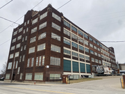 The Dorn Color Inc. building, located on Berea Rd. in Cudell.
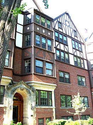
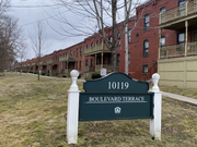 Boulevard Terrace, an apartment complex located near the West Boulevard-Cudell Station.
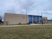 The Cudell Recreation Center, the site of the shooting of Tamir Rice.
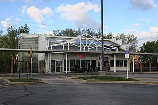
 The West Boulevard-Cudell station, which provides RTA Rapid Transit service to the neighborhood and is located at the intersection of Detroit Ave. and West Blvd. in Cudell.
 Cudell Tower, a monument to Frank E. Cudell located in Cudell Commons.
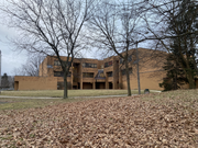 Marion C. Seltzer Elementary School, located in Cudell Commons.
 Cleveland Fire Station no. 23, located on Madison Ave. in Cudell.