
Garfield Heights is a city in Cuyahoga County, Ohio, United States. The population was 29,781 at the time of the 2020 census. A suburb of Cleveland, it is a part of the Cleveland metropolitan area.

Cuyahoga Valley National Park is an American national park in Ohio that preserves and reclaims the rural landscape along the Cuyahoga River between Akron and Cleveland in Northeast Ohio.

The Blackfeet Nation, officially named the Blackfeet Tribe of the Blackfeet Indian Reservation of Montana, is a federally recognized tribe of Siksikaitsitapi people with an Indian reservation in Montana. Tribal members primarily belong to the Piegan Blackfeet band of the larger Blackfoot Confederacy that spans Canada and the United States.

Squire's Castle is a shell of a building located in the North Chagrin Reservation of the Cleveland Metroparks in Willoughby Hills, Ohio.

Downtown Cleveland is the central business district of Cleveland, Ohio, United States. The economic and cultural center of the city and the Cleveland metropolitan area, it is Cleveland's oldest district, with its Public Square laid out by city founder General Moses Cleaveland in 1796.
Tinker's Creek, in Cuyahoga, Summit and Portage counties of Ohio, is the largest tributary of the Cuyahoga River, providing about a third of its flow into Lake Erie.

Old Brooklyn is a neighborhood on the West Side of Cleveland, Ohio, United States, located approximately five miles south of downtown Cleveland. It extends east-to-west from the Cuyahoga River to the city of Brooklyn and north-to-south from the Brookside Park Valley to the city of Parma. It is home to the Cleveland Metroparks, including the Cleveland Zoo; the Jesse Owens tree at James Ford Rhodes High School; and the Benjamin Franklin Community Garden, the largest urban community garden in Cuyahoga County. Old Brooklyn has recently adopted the slogan "Old Brooklyn, a great place to grow" to commemorate its history and potential growth.

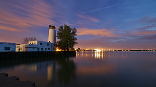
Cleveland Burke Lakefront Airport is a city-owned airport on the shore of Lake Erie, in the northeast part of downtown Cleveland, Ohio, United States. It's classified as a general aviation airport and is an FAA designated reliever to Cleveland Hopkins International Airport (CLE), which is Greater Cleveland's primary airport. In 2018, based on FAA data, Burke Lakefront was the seventh busiest airport in the state of Ohio. It is named after former Cleveland mayor and U.S. senator Thomas A. Burke.

Cleveland Metroparks is an extensive system of nature preserves in Greater Cleveland, Ohio. Eighteen reservations, which largely encircle the city of Cleveland, follow along the shore of Lake Erie and the rivers and creeks that flow through the region. Referred to unofficially as the 'Emerald Necklace', the network of parks spans over 25,000 acres (10,000 ha) and includes over 300 miles (480 km) of walking, bicycle, and horse trails as well as numerous picnic areas, nature education centers, golf courses, and countless fishing spots. In addition, the district includes the zoo in Cleveland. Four of the reservations are adjacent to Cuyahoga Valley National Park.
Summit Metro Parks is a Metroparks system serving the citizens of Summit County, Ohio by managing 14,000 acres (5,700 ha) in 16 developed parks, six conservation areas and more than 150 miles (240 km) of trails, with 22.4 miles (36.0 km) of the Ohio & Erie Canal Towpath Trail.
The Cleveland Memorial Shoreway, often shortened to "the Shoreway", is a limited-access freeway in Cleveland and Bratenahl, Ohio. It closely follows the shore of Lake Erie and connects the east and west sides of Cleveland via the Main Avenue Bridge over the Cuyahoga River. The entire length of the Shoreway is part of the Lake Erie Circle Tour (LECT) and all but the very eastern end of the Shoreway is part of State Route 2. The Shoreway also carries parts of Interstate 90 and State Route 283 on its eastern side, and parts of U.S. Route 6 and U.S. Route 20 on its western side. The Cleveland neighborhood of Detroit-Shoreway is named after the two roads that form the northern border, the Shoreway and Detroit Avenue.

The Chicago Park District is one of the oldest and the largest park districts in the United States. As of 2016, there are over 600 parks included in the Chicago Park District as well as 27 beaches, 10 boat docking harbors, two botanic conservatories, a zoo, and 11 museums, along with one stadium. The Chicago Park District also has more than over 230 field houses, 78 public pools, and dozens of sports and recreational facilities, with year-round programming. It also owns and operates the lakefront stadium, Soldier Field, which the Chicago Bears and Chicago Fire FC lease. The district is an independent taxing authority as defined by Illinois State Statute and is considered a separate agency of the City of Chicago. The district's headquarters are located in the Brighton Park neighborhood.

North Coast Harbor is a district in downtown Cleveland, Ohio, United States, on the shore of Lake Erie. The district serves as the home of the Great Lakes Science Center, the Rock and Roll Hall of Fame and Museum, FirstEnergy Stadium, the Steamship William G. Mather Maritime Museum, USS Cod, Burke Lakefront Airport, Voinovich Bicentennial Park, and the Cleveland-Cuyahoga County Port Authority. It is served by the West 3rd and North Coast stations on RTA's light rail Waterfront Line.

Glenville is a neighborhood on the East Side of Cleveland, Ohio. To the north, it borders the streetcar suburb of Bratenahl, the Cleveland Memorial Shoreway, and the Lake Erie shore, encompassing the Cleveland Lakefront Nature Preserve. To the east, it borders the suburb of East Cleveland, and to the south, it borders the neighborhoods of Hough and University Circle. Glenville borders the Collinwood area to the northeast at East 134th Street, and St. Clair–Superior to the west at Martin Luther King Jr. Boulevard and the Cleveland Cultural Gardens in Rockefeller Park.
Whiskey Island is a peninsula at the mouth of the Cuyahoga River at Lake Erie in Cleveland, Ohio. Its current configuration was created in 1827 when the river's mouth was moved to its present location. Part of the city's Cuyahoga Valley neighborhood, the peninsula is 1 mile (1.6 km) long and 0.3 miles (0.48 km) at its widest, bounded by Lake Erie to the north, West 54th Street on the west (roughly), and the Cuyahoga River to the south and east.

Rockefeller Park is a city park named in honor of oil magnate John D. Rockefeller Sr., located in Cleveland, Ohio. Part of the Cleveland Public Parks District, Rockefeller Park is immediately adjacent Wade Park to the southeast, and across Euclid Ave on its northwest border. Besides the distinction of being the largest park located completely within city limits, Rockefeller Park is a link in a chain of parkland that connects the heights region of the eastern suburbs to the city's lakefront. Following the path of Martin Luther King Jr. Drive and spanning a large section of Cleveland's East Sides, the park runs in a northwesterly path between suburban Shaker Heights, bisecting the University Circle neighborhood and terminating at Gordon Park on the city's lakefront, opened to the public in 1897. The park was dramatically expanded during the 1930s with labor provided by the Works Progress Administration. Landmarks found in Rockefeller Park include two separate entries on the National Register of Historic Places: one for its architecturally historic bridges, and one for its Cultural Gardens.

The Cleveland Foundation Centennial Lake Link Trail, originally known as the Lake Link Trail, is a cycling, hiking, and walking trail located in the city of Cleveland, Ohio, in the United States. Owned by the city of Cleveland and maintained by Cleveland Metroparks, the trail runs along the former track bed of the Cleveland and Mahoning Valley Railroad. The trail is named for The Cleveland Foundation, a local community foundation which donated $5 million toward the trail's construction. The southern leg of the 1.3-mile (2.1 km) trail opened in August 2015, and the northern leg in August 2017. The middle leg will begin construction once the Irishtown Bend hillside is stabilized. A bridge connecting the trail to Whiskey Island will begin construction in Spring 2019 and will be completed in early Summer 2020.

Euclid Creek is a 43-mile (69 km) long stream located in Cuyahoga and Lake counties in the state of Ohio in the United States. The 11.5-mile (18.5 km) long main branch runs from the Euclid Creek Reservation of the Cleveland Metroparks to Lake Erie. The west branch is usually considered part of the main branch, and extends another 16 miles (26 km) to the creek's headwaters in Beachwood, Ohio. The east branch runs for 19 miles (31 km) and has headwaters in Willoughby Hills, Ohio.

Edgewater is a neighborhood on the West Side of Cleveland, Ohio. Located along the Lake Erie shoreline, it is situated approximately five miles west of downtown Cleveland. It extends east-to-west from the neighborhood of Detroit–Shoreway to the streetcar suburb of Lakewood and north-to-south from Lake Erie to the neighborhood of Cudell.

