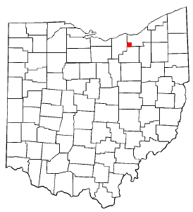
Cuyahoga County is a large urban county located in the northeastern part of the U.S. state of Ohio. The county seat and largest city is Cleveland. As of the 2020 census, its population was 1,264,817, making it the second-most populous county in the state.

Fairview Park is a city in Cuyahoga County, Ohio, United States. The population was 17,291 at the 2020 census. A suburb of Cleveland, it is a part of the Cleveland metropolitan area.

Lakewood is a city in Cuyahoga County, Ohio, United States, on the southern shore of Lake Erie. Established in 1889, it is one of Cleveland's historical streetcar suburbs and part of the Cleveland metropolitan area. The population was 50,942 at the 2020 census, making it the third largest city in Cuyahoga County, behind Cleveland and Parma.

The Cleveland metropolitan area, or Greater Cleveland as it is more commonly known, is the metropolitan area surrounding the city of Cleveland in Northeast Ohio, United States. According to the 2020 census results, the six-county Cleveland, OH Metropolitan Statistical Area (MSA) consists of Cuyahoga County, Ashtabula County, Geauga County, Lake County, Lorain County, and Medina County, and has a population of 2,185,825, making it the 33rd-most populous metropolitan area in the United States and the third largest metropolitan area in Ohio. The metro area is also part of the larger Cleveland–Akron–Canton Combined Statistical Area with a population of over 3.7 million people, the most populous statistical area in Ohio and the 17th most populous in the United States.

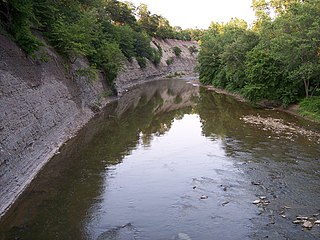
The Rocky River is a relatively short river in Cuyahoga County, Ohio that forms the natural western boundaries of Cleveland and the suburb of Lakewood with the suburbs of Fairview Park and Rocky River. The latter community is named after the river. To the south of Fairview Park and west of Cleveland Hopkins International Airport, the river forms the natural boundary between the suburb of Brook Park and the communities of North Olmsted and Olmsted Township. Ranked by Field & Stream as one of the top steelhead trout rivers in the world, the Rocky River is the center of the Rocky River Reservation of the Cleveland Metroparks.

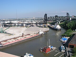
The Flats is a mixed-use industrial, recreational, entertainment, and residential area of the Cuyahoga Valley neighborhood of Cleveland, Ohio, U.S. The name reflects its low-lying topography on the banks of the Cuyahoga River.

Old Brooklyn is a neighborhood on the West Side of Cleveland, Ohio, United States, located approximately five miles south of downtown Cleveland. It extends east-to-west from the Cuyahoga River to the city of Brooklyn and north-to-south from the Brookside Park Valley to the city of Parma. It is home to the Cleveland Metroparks, including the Cleveland Zoo; the Jesse Owens tree at James Ford Rhodes High School; and the Benjamin Franklin Community Garden, the largest urban community garden in Cuyahoga County. Old Brooklyn has recently adopted the slogan "Old Brooklyn, a great place to grow" to commemorate its history and potential growth.

Ohio City is one of the oldest neighborhoods in Cleveland, Ohio. It is located immediately west of the Cuyahoga River.
Sun Newspapers was formed as a chain of weekly newspapers serving Northeast Ohio. Prior to a major reorganization in 2013, the chain consisted of 11 weekly newspapers serving 49 different communities in Greater Cleveland. The papers are focused on suburbs and exurbs in Cuyahoga, Geauga, Lorain and Medina counties. Its offices are in Valley View.

Kamm's Corners is a neighborhood on the West Side of Cleveland, Ohio. It is bounded by the streetcar suburb of Lakewood to the north, the Rocky River Reservation of the Cleveland Metroparks and the suburbs of Rocky River and Fairview Park to the west, the New York Central Railroad tracks to the east, and Puritas Road to the south. Kamm's Corners Plaza and Warren Village are the major retail centers of the neighborhood. According to the 2019 U.S. census estimate, the neighborhood has the highest concentration of Irish Americans in Cleveland and Cuyahoga County.

Columbia Township, also known as Columbia Station or just Columbia, is the easternmost of the eighteen townships of Lorain County, Ohio, United States. Columbia Township is the official government name, while Columbia Station is the post office name, and tends to be the town name used by residents. The post office name was chosen to differentiate the township from other Columbia Townships statewide, located in Hamilton and Meigs counties.

Olmsted Township is a township located in Cuyahoga County, Ohio, United States. Situated in the southwest end of the county, Olmsted Township is a west side suburb of Cleveland, and a part of the even larger Greater Cleveland area. As of the 2020 Census, Olmsted Township had a population of 14,506. It is one of only two civil townships remaining in Cuyahoga County, and the only Olmsted Township statewide.

Cuyahoga County, Ohio, United States is divided into 21 townships.

Detroit–Shoreway is a neighborhood on the West Side of Cleveland, in the U.S. state of Ohio. Detroit–Shoreway consists of the streets between Lake Erie and Interstate 90, from West 85th to West 45th streets.

The MetroHealth System is a nationally ranked non-profit, public health care system located in Cleveland, Ohio. Founded in 1837 as City Hospital, The MetroHealth System serves the residents of the city of Cleveland and Cuyahoga County. It is one of the three major health care systems in Cleveland, Ohio, along with Cleveland Clinic and University Hospitals of Cleveland.

Jefferson is a neighborhood on the West Side of Cleveland, Ohio. It is bounded by the neighborhoods of West Boulevard and Cudell and the village of Linndale to the east, Bellaire–Puritas to the south, Kamm's Corners to the west, and the streetcar suburb of Lakewood to the north. It is one of four sub-neighborhoods that comprise the larger historical neighborhood of West Park, the others being Kamm's Corners, Bellaire–Puritas, and Hopkins.

U.S. Route 6 (US 6) is a part of the United States Numbered Highway System that runs from Bishop, California, to Provincetown, Massachusetts. In Ohio, the road runs west–east from the Indiana state line near Edgerton to the Pennsylvania state line near Andover. The 248.002 miles (399.121 km) that lie in Ohio are maintained by the Ohio Department of Transportation (ODOT). US 6 serves the major cities of Sandusky, Lorain, and Cleveland. The highway is also called the Grand Army of the Republic Highway to honor the Union forces of the U.S. Civil War. The alternate name was designated in 1953.

The demographics of Cleveland have fluctuated throughout the city's history. From its founding in 1796, the city's population grew to 261,353 by 1890, and to 796,841 by 1920, making it the fifth largest city in the United States at the time. By 1930, the population rose to 900,429 and, after World War II, it reached 914,808. Due to various historical factors including deindustrialization, suburbanization, and urban sprawl, Cleveland's population began decreasing in the 1960s. By 1970, the city's population was 750,903. By 1980, it was 573,822 and it had lost its position as one of the top 10 largest cities in the U.S. By 2020, the population had further fallen to 372,624. Beginning in 2018, the city's population began to flatten, after decades of decline. Additionally, between 2010 and 2020, several neighborhoods within Cleveland saw a significant population increase, most notably Downtown, but also University Circle and several West Side neighborhoods.

Bellaire–Puritas is a neighborhood on the West Side of Cleveland, Ohio, in the United States. Originally part of the Village of West Park, it was annexed by the city in 1923. Formerly known as Puritas–Longmead, the neighborhood takes its name from the two streets which form its northern boundary: Puritas Avenue and Bellaire Road.

Hopkins is a neighborhood on the West Side of Cleveland, Ohio. Known as Riverside until 2014, it borders the neighborhoods of Kamm's Corners and Bellaire–Puritas to the north and northeast, the suburb of Fairview Park to the northwest, and Brook Park to the south, east, and west. Most of the area of Hopkins is covered by Cleveland Hopkins International Airport. Consequently, the neighborhood has "one of Cleveland's lowest population levels as well as the lowest level of population density."


