
The North Loop is a neighborhood in the Central community of Minneapolis.
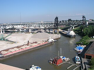
The Flats is a mixed-use industrial, recreational, entertainment, and residential area of the Cuyahoga Valley neighborhood of Cleveland, Ohio, U.S. The name reflects its low-lying topography on the banks of the Cuyahoga River.

Spaghetti Warehouse is an Italian restaurant chain geared towards families with five physical locations in two U.S. states: four in Ohio, one in New York (state). They also operate a to-go only location in Texas. The chain started in 1972 in Dallas, Texas, and at one point had spread throughout the southern and eastern parts of the United States. Each restaurant has a trolley car in the dining room and patrons are able to sit in the car. One of Spaghetti Warehouse's unique characteristics is that many of the older locations are in renovated, historic buildings.

The Automobile Alley neighborhood and Automobile Alley Historic District in Oklahoma City is an upscale Urban area, located roughly along North Broadway Avenue in Downtown Oklahoma City. The district contains numerous low and mid-rise heritage buildings once home to the city's automobile dealerships, that today hosts many of the city's top bars and restaurants, retail shops, and urban residences alongside modern construction consisting mostly of residential housing and hotels. Automobile Alley is listed in the National Historic Register of neighborhoods.

Downtown Cleveland is the central business district of Cleveland, Ohio. The economic and symbolic center of the city and the Cleveland-Akron-Canton, OH Combined Statistical Area, it is Cleveland's oldest district, with its Public Square laid out by city founder General Moses Cleaveland in 1796.

Ohio City is one of the oldest neighborhoods in Cleveland, Ohio. It is located immediately west of the Cuyahoga River.
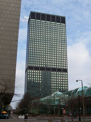
The Erieview Tower is a skyscraper featuring elements of the International style located in downtown Cleveland, Ohio, United States. The building has 40 stories, rises to a height of 529 ft, and has 703,000 square feet (65,300 m2) of office space. It was built at a cost of $24,000,000. It is slated to become the Cleveland W Hotel.

The Old Market is a neighborhood located in downtown Omaha, Nebraska, United States, and is bordered by South 10th Street to the east, 13th Street to the west, Farnam Street to the north and Jackson Street to the South. The neighborhood has many restaurants, art galleries and upscale shopping. The area retains its brick paved streets from the turn of the 20th century, horse-drawn carriages, and covered sidewalks in some areas. It is not uncommon to see a variety of street performers, artists, and other vendors.
The Allentown district is a neighborhood in Buffalo, New York. The neighborhood is home to the Allentown Historic District.

Shockoe Slip is a district in the downtown area of Richmond, Virginia. The name "slip" referred to a narrow passageway leading from Main Street to where goods were loaded and unloaded from the former James River and Kanawha Canal. The rough boundaries of Shockoe Slip include 14th Street, Main Street, Canal Street and 12th Street.

Downtown Columbus is the central business district of Columbus, Ohio. Downtown is centered on the intersection of Broad and High Streets, and encompasses all of the area inside the Inner Belt. Downtown is home to most of the tallest buildings in Columbus.
Steven B. Smith, is an underground artist and poet from Cleveland, Ohio. He published ArtCrimes, a zine influenced by the beats. Smith's art and poetry uses cultural themes as found objects with a Dadaist influence.

Downtown Norfolk serves as the traditional center of commerce, government, and culture in the Hampton Roads region. Norfolk, Virginia's downtown waterfront shipping and port activities historically played host to numerous and often noxious port and shipping-related uses. With the advent of containerized shipping in the mid-19th century, the shipping uses located on Norfolk's downtown waterfront became obsolete as larger and more modern port facilities opened elsewhere in the region. The vacant piers and cargo warehouses eventually became a blight on downtown and Norfolk's fortunes as a whole. But in the second half of the century, Norfolk had a vibrant retail community in its suburbs; companies like Smith & Welton, High's, Colonial Stores, Goldman's Shoes, Lerner Shops, Hofheimer's, Giant Open Air, Dollar Tree and K & K Toys were regional leaders in their respective fields. Norfolk was also the birthplace of Econo-Travel, now Econo Lodge, one of the nation's first discount motel chains.

Downtown Omaha is the central business, government and social core of the Omaha-Council Bluffs metropolitan area, U.S. state of Nebraska. The boundaries are Omaha's 20th Street on the west to the Missouri River on the east and the centerline of Leavenworth Street on the south to the centerline of Chicago Street on the north, also including the CHI Health Center Omaha. Downtown sits on the Missouri River, with commanding views from the tallest skyscrapers.

The Lowertown Historic District is a historic district in the Lowertown neighborhood of Saint Paul, Minnesota, United States. This 16-block warehouse and wholesaling district comprises 37 contributing properties built 1870s–1920. It was listed on the National Register of Historic Places in 1983 for the significance of its river and rail connections, economic impact, architecture, and urban planning. Lowertown was originally the lower landing on the Mississippi River; the first port of access to the Twin Cities. Several warehouse, railroad, banking, and distribution buildings served the entire Upper Midwest from 1880 to 1920. A significant concentration of these buildings survive, unified by similar architectural styles and construction materials. Many were designed by the city's most prestigious architects, including Cass Gilbert and Clarence H. Johnston Sr.

Downtown Saint Paul is the central business district of Saint Paul, Minnesota, United States. Its boundaries are the Mississippi River to the south, University Avenue to the north, US 52 to the east, and Kellogg Avenue to the west. It is bounded by the Dayton's Bluff, Summit-University, West Seventh, Frogtown, West Side, and Payne-Phalen neighborhoods. The West Side neighborhood is on the other side of the river, and can be accessed via the Robert Street Bridge or the Wabasha Street Bridge. Interstate 35E and Interstate 94 run through the north side of the neighborhood, providing a separation between the Minnesota State Capitol and other state government buildings with the rest of downtown.

Tremont is a neighborhood on the West Side of Cleveland, Ohio. Listed on the National Register of Historic Places, the district sits just south of the Ohio City neighborhood. It is bounded by the Cuyahoga Valley to the north and east, MetroHealth medical center to the south, and West 25th Street and Columbus Road to the west.

Downtown Cincinnati is the central business district of Cincinnati, Ohio, United States, as well the economic and symbiotic center of the Cincinnati metropolitan area. It also contains a number of urban neighborhoods in the low land area between the Ohio River and the high land areas of uptown. These neighborhoods include Over-the-Rhine, Pendleton, Queensgate, and West End.

Shockoe Valley is an area in Richmond, Virginia, just east of downtown, along the James River, and is the entertainment center of the city. Located between Shockoe Hill and Church Hill, Shockoe Valley contains much of the land included in Colonel William Mayo's 1737 plan of Richmond, making it one of the city's oldest neighborhoods. Shockoe Valley encompasses the smaller neighborhoods of Shockoe Slip, Shockoe Bottom and Tobacco Row along Cary Street.
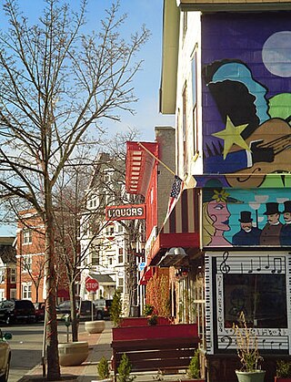
East 4th Street is a major pedestrian zone in Downtown Cleveland, Ohio, known for its food, entertainment, and nightlife. The street runs south from Euclid Avenue to Prospect Avenue. Once a very run down street, the area has been renovated and revitalized by the establishment of numerous restaurants, bars, nightclubs, and apartments, turning it into one of the main nightlife hotspots in the city.


