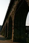
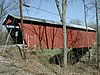
Name Image Built Listed Location County Type "S" Bridge II 1828 1973-04-23 New Concord 39°59′35″N 81°44′48″W / 39.99306°N 81.74667°W / 39.99306; -81.74667 ("S" Bridge II ) Muskingum Adams Covered Bridge 1875 1999-02-05 Malta 39°37′27″N 82°1′58″W / 39.62417°N 82.03278°W / 39.62417; -82.03278 (Adams Covered Bridge ) Morgan Covered bridge B & O Railroad Viaduct 1871 1976-06-22 Bellaire 40°0′47″N 80°44′40″W / 40.01306°N 80.74444°W / 40.01306; -80.74444 (B & O Railroad Viaduct ) Belmont Roman-arched Viaduct Ballard Road Covered Bridge 1883 1975-05-29 Jamestown 39°40′41″N 83°48′55″W / 39.67806°N 83.81528°W / 39.67806; -83.81528 (Ballard Road Covered Bridge ) Greene Howe Truss Barkhurst Mill Covered Bridge 1872 1999-02-05 Chesterhill 39°30′10″N 81°50′3″W / 39.50278°N 81.83417°W / 39.50278; -81.83417 (Barkhurst Mill Covered Bridge ) Morgan Covered bridge Bell Covered Bridge 2012-10-3 Vincent 39°25′52″N 81°40′34″W / 39.43111°N 81.67611°W / 39.43111; -81.67611 (Bell Covered Bridge ) Washington Belle Hall Covered Bridge 1879 1976-10-22 Croton 40°14′8″N 82°38′26″W / 40.23556°N 82.64056°W / 40.23556; -82.64056 (Belle Hall Covered Bridge ) Licking Multiple kingpost truss plan Bennett Schoolhouse Road Covered Bridge 1867 1978-10-11 Minford 38°49′45″N 82°48′26″W / 38.82917°N 82.80722°W / 38.82917; -82.80722 (Bennett Schoolhouse Road Covered Bridge ) Scioto King post truss Bergstresser Covered Bridge 1887 1974-05-03 Canal Winchester 39°49′48″N 82°49′0″W / 39.83000°N 82.81667°W / 39.83000; -82.81667 (Bergstresser Covered Bridge ) Franklin Partridge truss Black River Viaduct, Baltimore And Ohio Railroad 1890, 1892 1976-05-06 Lodi 41°1′38″N 82°2′29″W / 41.02722°N 82.04139°W / 41.02722; -82.04139 (Black River Viaduct, Baltimore And Ohio Railroad ) Medina Blackwood Covered Bridge 1881 1978-06-23 Athens 39°11′50″N 81°58′29″W / 39.19722°N 81.97472°W / 39.19722; -81.97472 (Blackwood Covered Bridge ) Athens King post truss, covered Blaine Hill "S" Bridge 2010-03-17 Blane Belmont Bowman Mill Covered Bridge ca. 1880 1978-02-08 New Reading 39°47′53″N 82°21′40″W / 39.79806°N 82.36111°W / 39.79806; -82.36111 (Bowman Mill Covered Bridge ) Perry Multiple kingpost truss John Bright Covered Bridge 1881 1975-05-28 Baltimore 39°49′50″N 82°40′23″W / 39.83056°N 82.67306°W / 39.83056; -82.67306 (John Bright Covered Bridge ) Fairfield One-Span Combination Truss Ohio University -Lancaster Broadway Bridge 1909 1996-02-22 Greenville 40°6′15″N 84°38′5″W / 40.10417°N 84.63472°W / 40.10417; -84.63472 (Broadway Bridge ) Darke Three-hinged arch Brubaker Covered Bridge 1887 1975-06-11 Gratis 39°39′6″N 84°32′39″W / 39.65167°N 84.54417°W / 39.65167; -84.54417 (Brubaker Covered Bridge ) Preble One-span Childs truss Buckeye Furnace Covered Bridge 1872 1975-02-24 Wellston 39°3′16″N 82°27′35″W / 39.05444°N 82.45972°W / 39.05444; -82.45972 (Buckeye Furnace Covered Bridge ) Jackson Smith Truss Byer Covered Bridge ca. 1870 1975-10-21 Byer 39°10′46″N 82°37′52″W / 39.17944°N 82.63111°W / 39.17944; -82.63111 (Byer Covered Bridge ) Jackson Smith Truss Caledonia Bowstring Bridge 1873, 1976 1978-05-23 Caledonia 40°38′33″N 82°57′56″W / 40.64250°N 82.96556°W / 40.64250; -82.96556 (Caledonia Bowstring Bridge ) Marion Bowstring arch-truss Chambers Road Covered Bridge 1874 1974-11-21 Olive Green 40°20′17″N 82°49′5″W / 40.33806°N 82.81806°W / 40.33806; -82.81806 (Chambers Road Covered Bridge ) Delaware Childs Truss Christman Covered Bridge 1895 1976-10-22 Eaton 39°46′13″N 84°39′20″W / 39.77028°N 84.65556°W / 39.77028; -84.65556 (Christman Covered Bridge ) Preble One-span Childs truss Church Hill Road Covered Bridge ca. 1870, 1982 1975-06-11 Lisbon 40°47′14″N 80°43′29″W / 40.78722°N 80.72472°W / 40.78722; -80.72472 (Church Hill Road Covered Bridge ) Columbiana Cincinnati and Whitewater Canal Tunnel 1837, 1846 2001-05-25 Cleves 39°9′18″N 84°44′58″W / 39.15500°N 84.74944°W / 39.15500; -84.74944 (Cincinnati and Whitewater Canal Tunnel ) Hamilton Brick lined canal tunnel Cleveland And Pittsburgh Railroad Bridge 1864 1975-07-24 Bedford 41°23′5″N 81°32′3″W / 41.38472°N 81.53417°W / 41.38472; -81.53417 (Cleveland And Pittsburgh Railroad Bridge ) Cuyahoga Viaduct Covington and Cincinnati Suspension Bridge 1856, 1867 1975-05-15 Cincinnati 39°5′32″N 84°30′34″W / 39.09222°N 84.50944°W / 39.09222; -84.50944 (Covington and Cincinnati Suspension Bridge ) Hamilton Suspension bridge Dean Road Bridge 1898 1978-11-28 Birmingham , South Amherst 41°20′56″N 82°20′41″W / 41.34889°N 82.34472°W / 41.34889; -82.34472 (Dean Road Bridge ) Erie , Lorain Pratt truss Detroit Avenue Bridge 1910 1973-02-23 Rocky River -Lakewood 41°28′57″N 81°49′53″W / 41.48250°N 81.83139°W / 41.48250; -81.83139 (Detroit Avenue Bridge ) Cuyahoga Detroit-Superior High Level Bridge 1917 1974-01-18 Cleveland 41°29′39″N 81°42′9″W / 41.49417°N 81.70250°W / 41.49417; -81.70250 (Detroit-Superior High Level Bridge ) Cuyahoga Double-deck bridge Dey Road Bridge 1906 1999-02-05 Defiance 41°17′25″N 84°23′8″W / 41.29028°N 84.38556°W / 41.29028; -84.38556 (Dey Road Bridge ) Defiance Pratt through truss bridge Dresden Suspension Bridge 1914 1978-12-01 Dresden 40°7′14″N 82°0′1″W / 40.12056°N 82.00028°W / 40.12056; -82.00028 (Dresden Suspension Bridge ) Muskingum Warren truss Eagle Creek Covered Bridge 1875 1975-12-06 Decatur 38°46′11″N 83°42′54″W / 38.76972°N 83.71500°W / 38.76972; -83.71500 (Eagle Creek Covered Bridge ) Brown Smith Truss Covered Bridge Eakin Mill Covered Bridge 1870, 1871 1976-03-16 Arbaugh 39°10′16″N 82°20′13″W / 39.17111°N 82.33694°W / 39.17111; -82.33694 (Eakin Mill Covered Bridge ) Vinton Kingpost truss Eldean Covered Bridge 1860 1975-02-20 Troy 40°4′40″N 84°13′0″W / 40.07778°N 84.21667°W / 40.07778; -84.21667 (Eldean Covered Bridge ) Miami Long truss Foreaker Bridge 1886, 1887 1975-06-05 Graysville 39°39′20″N 81°7′16″W / 39.65556°N 81.12111°W / 39.65556; -81.12111 (Foreaker Bridge ) Monroe Kingpost truss Geeting Covered Bridge 1894 1975-08-19 Lewisburg 39°50′37″N 84°35′50″W / 39.84361°N 84.59722°W / 39.84361; -84.59722 (Geeting Covered Bridge ) Preble One-span Childs truss General U.S. Grant Bridge 1927, 1939 2001-05-31 Portsmouth 38°43′50″N 82°59′49″W / 38.73056°N 82.99694°W / 38.73056; -82.99694 (General U.S. Grant Bridge ) Scioto Cable suspension bridge Harpersfield Covered Bridge 1873 1975-11-03 Harpersfield 41°45′22″N 80°56′40″W / 41.75611°N 80.94444°W / 41.75611; -80.94444 (Harpersfield Covered Bridge ) Ashtabula Howe truss covered bridge Harra Covered Bridge ca. 1875 1976-10-08 Watertown 39°29′16″N 81°38′53″W / 39.48778°N 81.64806°W / 39.48778; -81.64806 (Harra Covered Bridge ) Washington Long truss Harshaville Covered Bridge 1976-03-16 Harshaville 38°54′28″N 83°32′40″W / 38.90778°N 83.54444°W / 38.90778; -83.54444 (Harshaville Covered Bridge ) Adams Burr truss covered bridge Harshman Covered Bridge 1894 1976-09-29 Fairhaven 39°42′9″N 84°46′10″W / 39.70250°N 84.76944°W / 39.70250; -84.76944 (Harshman Covered Bridge ) Preble One-Span Childs Truss Helmick Covered Bridge 1863 1975-06-18 Blissfield 40°23′35″N 81°56′34″W / 40.39306°N 81.94278°W / 40.39306; -81.94278 (Helmick Covered Bridge ) Coshocton Two-Span Wooden Truss Helmick Mill Covered Bridge 1867 1999-02-05 Malta 39°43′11″N 81°56′32″W / 39.71972°N 81.94222°W / 39.71972; -81.94222 (Helmick Mill Covered Bridge ) Morgan Covered bridge Hildreth Covered Bridge 1878, ca. 1881 1978-02-08 Marietta 39°25′38″N 81°21′42″W / 39.42722°N 81.36167°W / 39.42722; -81.36167 (Hildreth Covered Bridge ) Washington Howe truss Jediah Hill Covered Bridge 1850 1973-03-28 Cincinnati 39°15′21″N 84°32′58″W / 39.25583°N 84.54944°W / 39.25583; -84.54944 (Jediah Hill Covered Bridge ) Hamilton Queenpost Truss Hizey Covered Bridge 1891 1976-10-08 Pickerington 39°53′53″N 82°40′9″W / 39.89806°N 82.66917°W / 39.89806; -82.66917 (Hizey Covered Bridge ) Fairfield Burr Truss Huffman Covered Bridge 1914 1975-03-04 Middleburg 39°39′37″N 81°22′13″W / 39.66028°N 81.37028°W / 39.66028; -81.37028 (Huffman Covered Bridge ) Noble Kingpost truss Hune Covered Bridge 1879 1976-10-08 Dart 39°30′38″N 81°15′2″W / 39.51056°N 81.25056°W / 39.51056; -81.25056 (Hune Covered Bridge ) Washington Long Truss Ida Street Viaduct 1931 1980-11-28 Cincinnati 39°6′19″N 84°29′40″W / 39.10528°N 84.49444°W / 39.10528; -84.49444 (Ida Street Viaduct ) Hamilton Interurban Bridge 1908 1972-06-19 Waterville 41°29′11″N 83°43′42″W / 41.48639°N 83.72833°W / 41.48639; -83.72833 (Interurban Bridge ) Lucas , Wood Reinforced concrete bridge John Bright No. 1 Iron Bridge 1978-09-20 Carroll 39°49′45″N 82°40′27″W / 39.82917°N 82.67417°W / 39.82917; -82.67417 (John Bright No. 1 Iron Bridge ) Fairfield One-Span Steel Eye-Bar Johnson Road Covered Bridge ca. 1870 1984-08-23 Petersburg 38°57′31″N 82°47′16″W / 38.95861°N 82.78778°W / 38.95861; -82.78778 (Johnson Road Covered Bridge ) Jackson Single span wooden truss Kidwell Covered Bridge 1880 1977-04-11 Truetown 39°27′21″N 82°6′13″W / 39.45583°N 82.10361°W / 39.45583; -82.10361 (Kidwell Covered Bridge ) Athens Howe truss covered bridge Kirker Covered Bridge ca. 1865-70 1975-10-29 West Union 38°47′3″N 83°36′13″W / 38.78417°N 83.60361°W / 38.78417; -83.60361 (Kirker Covered Bridge ) Adams Kingpost truss bridge, named for Ohio's second governor Knowlton Covered Bridge ca. 1860, ca. 1890 1980-03-11 Rinards Mills 39°36′4″N 81°9′26″W / 39.60111°N 81.15722°W / 39.60111; -81.15722 (Knowlton Covered Bridge ) Monroe Burr arch truss bridge Lockington Covered Bridge 1848 1975-06-10 Lockington 40°12′4″N 84°12′58″W / 40.20111°N 84.21611°W / 40.20111; -84.21611 (Lockington Covered Bridge ) Shelby Long truss; burned in 1989 Lorain-Carnegie Bridge 1927, 1932 1976-10-08 Cleveland 41°29′26″N 81°41′30″W / 41.49056°N 81.69167°W / 41.49056; -81.69167 (Lorain-Carnegie Bridge ) Cuyahoga Cantilever Deck Truss bridge Lynchburg Covered Bridge 1870 1976-03-16 Lynchburg 39°14′42″N 83°47′40″W / 39.24500°N 83.79444°W / 39.24500; -83.79444 (Lynchburg Covered Bridge ) Clinton , Highland Mark Road Bridge 1883 1990-07-26 Staunton 39°29′13″N 83°28′23″W / 39.48694°N 83.47306°W / 39.48694; -83.47306 (Mark Road Bridge ) Fayette Pratt through truss Martinsville Road Covered Bridge 1871 1974-09-10 Martinsville 39°19′47″N 83°50′6″W / 39.32972°N 83.83500°W / 39.32972; -83.83500 (Martinsville Road Covered Bridge ) Clinton Multiple kingpost Maysville-Aberdeen Bridge 1983-6-30 Aberdeen 38°39′19″N 83°45′27″W / 38.65528°N 83.75750°W / 38.65528; -83.75750 (Maysville-Aberdeen Bridge ) Brown Spans the Ohio River between Aberdeen and Maysville, Kentucky McColly Covered Bridge 1876 1975-05-28 Bloom Center 40°24′3″N 83°55′27″W / 40.40083°N 83.92417°W / 40.40083; -83.92417 (McColly Covered Bridge ) Logan Howe truss covered bridge Mill Creek Park Suspension Bridge 1895 1976-10-29 Youngstown 41°4′24″N 80°41′21″W / 41.07333°N 80.68917°W / 41.07333; -80.68917 (Mill Creek Park Suspension Bridge ) Mahoning Mill Road Bowstring Bridge ca. 1876 1979-12-05 Bladensburg 40°16′35″N 82°16′22″W / 40.27639°N 82.27278°W / 40.27639; -82.27278 (Mill Road Bowstring Bridge ) Knox Bow-string arch-truss Mt. Olive Road Covered Bridge 1875 1976-10-08 Allensville 39°17′10″N 82°35′21″W / 39.28611°N 82.58917°W / 39.28611; -82.58917 (Mt. Olive Road Covered Bridge ) Vinton Queenpost truss Mull Covered Bridge 1851 1974-10-15 Burgoon 41°15′38″N 83°11′4″W / 41.26056°N 83.18444°W / 41.26056; -83.18444 (Mull Covered Bridge ) Sandusky Town Lattice truss Newport and Cincinnati Bridge 1868, 1872, 1896 2001-04-17 Cincinnati 39°6′3″N 84°30′2″W / 39.10083°N 84.50056°W / 39.10083; -84.50056 (Newport and Cincinnati Bridge ) Hamilton Subdivided Pratt truss Newton Falls Covered Bridge 1831 1974-10-16 Newton Falls 41°11′17″N 80°58′17″W / 41.18806°N 80.97139°W / 41.18806; -80.97139 (Newton Falls Covered Bridge ) Trumbull Town latice truss Ohio State Route 51 Bridge Over the Portage River 1994-4-16 Elmore 41°28′37″N 83°17′44″W / 41.47694°N 83.29556°W / 41.47694; -83.29556 (Ohio State Route 51 Bridge Over the Portage River ) Ottawa Closed spandral arch Old Enon Road Stone Arch Culvert 2009-03-17 Enon 39°52′10.36″N 83°52′45.94″W / 39.8695444°N 83.8794278°W / 39.8695444; -83.8794278 (Old Enon Road Stone Arch Culvert ) Clark O'Shaughnessy Dam and Bridge 1922, 1925 1990-07-05 Shawnee Hills 40°9′13″N 83°8′14″W / 40.15361°N 83.13722°W / 40.15361; -83.13722 (O'Shaughnessy Dam and Bridge ) Delaware Second Renaissance Revival Otway Covered Bridge 1874 1974-05-03 Otway 38°51′46″N 83°11′24″W / 38.86278°N 83.19000°W / 38.86278; -83.19000 (Otway Covered Bridge ) Scioto Palos Covered Bridge 1977-11-11 Glouster 39°31′31″N 82°4′19″W / 39.52528°N 82.07194°W / 39.52528; -82.07194 (Palos Covered Bridge ) Athens Multiple kingpost truss Parker Covered Bridge 1873 1975-03-31 Upper Sandusky 40°54′11″N 83°14′41″W / 40.90306°N 83.24472°W / 40.90306; -83.24472 (Parker Covered Bridge ) Wyandot Howe Truss Parks Covered Bridge 1883 1974-09-10 Chalfunts 39°51′8″N 82°16′46″W / 39.85222°N 82.27944°W / 39.85222; -82.27944 (Parks Covered Bridge ) Perry Multiple kingpost truss Ponn Humpback Covered Bridge 1874 1973-04-11 Wilkesville 39°2′52″N 82°22′35″W / 39.04778°N 82.37639°W / 39.04778; -82.37639 (Ponn Humpback Covered Bridge ) Vinton Burr arch Pugh's Mill Covered Bridge ca. 1869 1975-06-05 Oxford 39°31′26″N 84°44′6″W / 39.52389°N 84.73500°W / 39.52389; -84.73500 (Pugh's Mill Covered Bridge ) Butler Two-Span Wooden Truss Reed Covered Bridge 1975-03-04 Marysville 40°8′59″N 83°22′50″W / 40.14972°N 83.38056°W / 40.14972; -83.38056 (Reed Covered Bridge ) Union Partridge truss Rinard Covered Bridge 1876 1976-10-08 Marietta 39°32′12″N 81°13′23″W / 39.53667°N 81.22306°W / 39.53667; -81.22306 (Rinard Covered Bridge ) Washington Smith truss Roberts Covered Bridge 1829 1971-09-03 Eaton 39°42′41″N 84°37′15″W / 39.71139°N 84.62083°W / 39.71139; -84.62083 (Roberts Covered Bridge ) Preble Burr Arch & Truss Rock Mill Covered Bridge 1901 1976-04-26 Rock Mill 39°44′56″N 82°42′48″W / 39.74889°N 82.71333°W / 39.74889; -82.71333 (Rock Mill Covered Bridge ) Fairfield Queen Post Truss Rockefeller Park Bridges 1897, 1907 1977-09-27 Cleveland Cuyahoga Richardsonian bridge Rodrick Bridge 1872 1998-05-22 Newark 40°4′5″N 82°26′26″W / 40.06806°N 82.44056°W / 40.06806; -82.44056 (Rodrick Bridge ) Licking Whipple bowstring truss Root Covered Bridge 1878 1975-03-27 Decaturville 39°20′33″N 81°45′16″W / 39.34250°N 81.75444°W / 39.34250; -81.75444 (Root Covered Bridge ) Washington Long truss S Bridge, National Road 1828 1966-10-15 Old Washington 40°2′43″N 81°22′27″W / 40.04528°N 81.37417°W / 40.04528; -81.37417 (S Bridge, National Road ) Guernsey Single span arch Salt Creek Covered Bridge 1876 1974-09-10 Norwich 39°59′55″N 81°50′24″W / 39.99861°N 81.84000°W / 39.99861; -81.84000 (Salt Creek Covered Bridge ) Muskingum Warren truss Scottown Covered Bridge 1874 1975-11-12 Scottown 38°32′52″N 82°22′49″W / 38.54778°N 82.38028°W / 38.54778; -82.38028 (Scottown Covered Bridge ) Lawrence Multiple Kingpost Shinn Covered Bridge 1886 1976-10-08 Bartlett 39°27′46″N 81°45′40″W / 39.46278°N 81.76111°W / 39.46278; -81.76111 (Shinn Covered Bridge ) Washington Burr arch truss bridge Smith Road Bridge 1890 1980-10-07 Bucyrus 40°55′37″N 83°2′8″W / 40.92694°N 83.03556°W / 40.92694; -83.03556 (Smith Road Bridge ) Crawford Bowstring Arch Truss South Salem Covered Bridge 1873 1975-03-04 South Salem 39°20′3″N 83°18′52″W / 39.33417°N 83.31444°W / 39.33417; -83.31444 (South Salem Covered Bridge ) Ross Smith truss St. Clair Street Bridge 1886, 1887 1978-09-21 Eaton 39°44′24″N 84°38′19″W / 39.74000°N 84.63861°W / 39.74000; -84.63861 (St. Clair Street Bridge ) Preble Pratt metal through-truss Station Road Bridge 1882 1979-03-07 Brecksville 41°19′10″N 81°35′16″W / 41.31944°N 81.58778°W / 41.31944; -81.58778 (Station Road Bridge ) Summit , Cuyahoga Pratt Whipple Truss Stonelick Covered Bridge 1878 1974-09-10 Perintown 39°7′52″N 84°11′14″W / 39.13111°N 84.18722°W / 39.13111; -84.18722 (Stonelick Covered Bridge ) Clermont Howe Truss Covered Bridge Superior Avenue Viaduct 1878 1978-06-09 Cleveland 41°29′41″N 81°42′16″W / 41.49472°N 81.70444°W / 41.49472; -81.70444 (Superior Avenue Viaduct ) Cuyahoga Roman Arch Viaduct Swartz Covered Bridge 1880 1976-10-08 Wyandot 40°46′14″N 83°10′9″W / 40.77056°N 83.16917°W / 40.77056; -83.16917 (Swartz Covered Bridge ) Wyandot Howe truss Teegarden-Centennial Covered Bridge 1875 2000-08-10 Salem 40°49′18″N 80°49′38″W / 40.82167°N 80.82722°W / 40.82167; -80.82722 (Teegarden-Centennial Covered Bridge ) Columbiana Covered bridge Third Street Bridge ca. 1885, 1913 1978-05-05 Canton 40°47′37″N 81°21′30″W / 40.79361°N 81.35833°W / 40.79361; -81.35833 (Third Street Bridge ) Stark Pratt through truss Twin Arch Stone Culvert 1837, 1913 1978-07-17 Troy 40°5′16″N 84°13′24″W / 40.08778°N 84.22333°W / 40.08778; -84.22333 (Twin Arch Stone Culvert ) Miami Warnke Covered Bridge 1895 1976-10-08 Lewisburg 39°52′26″N 84°30′53″W / 39.87389°N 84.51472°W / 39.87389; -84.51472 (Warnke Covered Bridge ) Preble One-span Childs truss West Fifth Street Bridge 1925 1985-08-23 Ashtabula 41°54′1″N 80°47′53″W / 41.90028°N 80.79806°W / 41.90028; -80.79806 (West Fifth Street Bridge ) Ashtabula Single leaf bascule West Orange Road-Thomas Bridge 1898, 1913 2002-06-26 Powell 40°10′31″N 83°2′44″W / 40.17528°N 83.04556°W / 40.17528; -83.04556 (West Orange Road-Thomas Bridge ) Delaware Pratt through Truss White Bridge 1877 1983-12-11 Poland Village 41°1′37″N 80°36′48″W / 41.02694°N 80.61333°W / 41.02694; -80.61333 (White Bridge ) Mahoning Oval tubular Arch Bowstring Wiswell Road Covered Bridge 1867, 1868 1973-04-11 Windsor Mills 41°31′59″N 80°57′50″W / 41.53306°N 80.96389°W / 41.53306; -80.96389 (Wiswell Road Covered Bridge ) Ashtabula Town lattice truss Y Bridge 1902 1973-11-02 Zanesville 39°56′25″N 82°0′48″W / 39.94028°N 82.01333°W / 39.94028; -82.01333 (Y Bridge ) Muskingum Zoarville Bridge 1868, 1905 1997-03-13 Zoarville 40°34′38″N 81°23′30″W / 40.57722°N 81.39167°W / 40.57722; -81.39167 (Zoarville Bridge ) Tuscarawas Fink truss bridge Blacklick Covered Bridge 1888 Pickerington Fairfield Howe truss Everett Road Covered Bridge ca. 1873, 1877 Peninsula Summit Smith truss Germantown Covered Bridge 1870 Germantown Montgomery Inverted bowstring bridge Loucks Covered Bridge 1871 Canal Winchester Fairfield Burr Truss Stemen Road Covered Bridge 1888 Pickerington Fairfield Howe Truss Turtle Creek Culvert and Embankment 1837, 1842 New Bern Shelby