Hizey Covered Bridge

Last updated

Hizey Covered Bridge
Hizey Covered Bridge.jpg
USA Ohio location map.svg
Red pog.svg
Nearest city Pickerington, Ohio
Arealess than one acre
Built1891
Built byBuchanan, James W.
Architectural styleBurr Truss
NRHP reference No. 76001423 [1]
Added to NRHPOctober 8, 1976

The Hizey Covered Bridge, in Fairfield County, Ohio, is a Burr Truss covered bridge which was built in 1891 by James W. Buchanan. It was listed on the National Register of Historic Places in 1976 when it was still located at its original location.

It was located east of Pickerington on State Route 235, [2] bringing Poplar Creek Road across Poplar Creek, at 39°53′54″N82°40′08″W / 39.898321°N 82.668960°W / 39.898321; -82.668960 (Original location of Hizey Covered Bridge) .

It is 83 feet (25 m) long. [3]

It was moved in 1979 [4] to a private drive a few miles away. It is now located on a private drive at 12549 Tollgate Rd., crossing Sycamore Creek (at 39°54′53″N82°42′33″W / 39.9146°N 82.7092°W / 39.9146; -82.7092 (Current location at 12549 Tollgate Rd.) ). [5]

It is in Violet Township.

Related Research Articles

<span class="mw-page-title-main">National Register of Historic Places listings in Michigan</span>

This is a list of properties on the National Register of Historic Places in the U.S. state of Michigan.
     This National Park Service list is complete through NPS recent listings posted January 17, 2025.

<span class="mw-page-title-main">National Register of Historic Places listings in Cuyahoga County, Ohio</span>

This is a list of the National Register of Historic Places listings in Cuyahoga County, Ohio.

<span class="mw-page-title-main">National Register of Historic Places listings in Hamilton County, Ohio</span>

This is a list of the National Register of Historic Places listings in Hamilton County, Ohio.

<span class="mw-page-title-main">National Register of Historic Places listings in Summit County, Ohio</span>

This is a list of the National Register of Historic Places listings in Summit County, Ohio.

<span class="mw-page-title-main">Byer, Ohio</span> Unincorporated community in Ohio, United States

Byer is an unincorporated community in northwestern Washington Township, Jackson County, Ohio, United States. It lies along State Route 327 between Wellston and Londonderry.

<span class="mw-page-title-main">National Register of Historic Places listings in Fairfield County, Ohio</span>

This is a list of the National Register of Historic Places listings in Fairfield County, Ohio.

<span class="mw-page-title-main">National Register of Historic Places listings in Licking County, Ohio</span>

This is a list of the National Register of Historic Places listings in Licking County, Ohio.

<span class="mw-page-title-main">National Register of Historic Places listings in Brown County, Ohio</span>

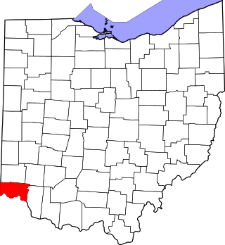
This is a list of the National Register of Historic Places listings in Brown County, Ohio.

<span class="mw-page-title-main">Grand Loop Road</span> United States historic place

The Grand Loop Road is a historic district which encompasses the primary road system in Yellowstone National Park. Much of the 140-mile (230 km) system was originally planned by Captain Hiram M. Chittenden of the US Army Corps of Engineers in the early days of the park, when it was under military administration. The Grand Loop Road provides access to the major features of the park, including the Upper, Midway and Lower geyser basins, Mammoth Hot Springs, Tower Fall, the Grand Canyon of the Yellowstone and Yellowstone Lake.

<span class="mw-page-title-main">National Register of Historic Places listings in Greene County, Pennsylvania</span>

This is a list of the National Register of Historic Places listings in Greene County, Pennsylvania.

<span class="mw-page-title-main">National Register of Historic Places listings in Clinton County, Ohio</span>

This is a list of the National Register of Historic Places listings in Clinton County, Ohio.

<span class="mw-page-title-main">National Register of Historic Places listings in Preble County, Ohio</span>

This is a list of the National Register of Historic Places listings in Preble County, Ohio.

<span class="mw-page-title-main">National Register of Historic Places listings in Jefferson County, Colorado</span> List of National Register of Historic Places in Jefferson County, Colorado, United States

This is a list of the National Register of Historic Places listings in Jefferson County, Colorado.

<span class="mw-page-title-main">National Register of Historic Places listings in Clear Creek County, Colorado</span>

This is a list of the National Register of Historic Places listings in Clear Creek County, Colorado.

This is a list of the National Register of Historic Places listings in Cuyahoga Valley National Park.

The historic bridges at the Lancaster campus of Ohio University were moved to the campus and sit about 100 yards (91 m) apart. The bridges were built in 1881 and 1884–85 very close to each other, both crossing Poplar Creek, and while the first-built is a wood-and-steel covered bridge and the second-built is all-steel, they are similar in design. Original and current locations of both bridges may be seen in OpenStreetMap linked at right.

<span class="mw-page-title-main">Bowman Mill Covered Bridge</span> United States historic place

The Bowman Mill Covered Bridge, in Perry County, Ohio, is a multiple kingpost truss covered bridge which was built in 1880. It was listed on the National Register of Historic Places in 1978.

<span class="mw-page-title-main">Roberts Covered Bridge</span> United States historic place

The Roberts Covered Bridge is a Burr Truss covered bridge in Preble County, Ohio near Eaton. It was built in 1829, and was listed on the National Register of Historic Places in 1971.

Slob Historic District, near Christiansted, Virgin Islands, is a historic district which was listed on the National Register of Historic Places in 1987. The listing included nine contributing buildings, three contributing structures, and a contributing site on 9 acres (3.6 ha).

<span class="mw-page-title-main">Great Basin Research Station Historic District</span> Historic district in Utah, United States

The Great Basin Research Station Historic District, in Ephraim Canyon near Ephraim, Utah, is a historic district that was listed on the National Register of Historic Places in 1996.

References

  1. "National Register Information System". National Register of Historic Places . National Park Service. November 2, 2013.
  2. Lorrie K. Owen, ed. (1999). Ohio Historic Places Dictionary, Volume 2. Somerset Publishers, Inc. p. 3. ISBN   9781878592705.
  3. this Archived 2012-02-17 at the Wayback Machine ODOT webpage
  4. "Nature Notes: Hizey Covered Bridge".
  5. Location derived from this Archived 2012-02-17 at the Wayback Machine ODOT webpage; the NRIS lists it at its previous location.